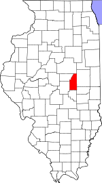
Piatt County, Illinois Basics:


Piatt County Illinois - Government Site

Population: 16,511
Area: 439 square miles
County seat: Monticello
Area code(s) in use: 217
Time zone: CST
High school graduate or higher: 92.7%
Bachelor's degree or higher: 24.8%
Median household income: $62,125
Persons in poverty: 6.3%
Home ownership rate: 83.5%
Mean travel time to work: 23.1 minutes


Adjacent counties:
Champaign  De Witt  Douglas  Macon  McLean  Moultrie  

Find in Illinois

Map of the Piatt County area


Our detail map of Piatt County shows the Piatt County, Illinois boundary lines and other interesting items.

Places in Piatt County, Illinois

  Airports     show all on map

Ashworth Landing Strip, Bartram Landing Strip, Clapper Airport, Gaitros Airport, Kirwan Landing Strip, Marvin D Bradd Airport, Morris Farm Incorporated Airport, Niklaus RLA Airport, Norfleet Airport, Norfleet Farms Airport, Piatt County Airport, Robert A Ashworth Airport, Spence Landing Strip, Triple Creek Airport, Van Gorder Airport, Weidner Landing Field, White Landing Strip

  Bridges     show all on map

County Line Bridge, Hog Chute Bridge

  Buildings     show all on map

Allerton Public Library, Atwood Fire Protection District, Bement Fire Protection District Station 1, Bement Fire Protection District Station 2, Cerro Gordo Community Ambulance Service, Cerro Gordo Fire Protection District, Cisco Fire Protection District, Deland Community Fire Protection District, Goose Creek Energy Center, Hammond Fire Protection District, Kirby Hospital Ambulance Service, Mansfield Public Library, Mid Piatt County Fire Protection District, Mid Piatt Fire Protection District Monticello, Monticello and Sangamon Valley Railway Museum, Monticello City Hall, Monticello Fire and Rescue, Monticello Fire and Rescue Training Facility, Northern Piatt County Fire Protection District, Piatt County Courthouse, Piatt County Jail

  Canals     show all on map

Ditch Number 4, Friends Creek Ditch, Hammond Mutual Ditch, Unity Number 3 Ditch, Washington Elementary School

  Cemeteries     show all on map

Antioch Cemetery, Argo Cemetery, Ater Cemetery, Bement Cemetery, Blue Ridge Cemetery, Boyer Cemetery, Bucks Pond Cemetery, Camp Creek Cemetery, Cerro Gordo Cemetery, Clover Cemetery, County Cemetery, Cronninger Cemetery, Deland Cemetery, Dillow Family Cemetery, Dooley Family Cemetery, Dunkard Cemetery, Hammond Cemetery, Haneline Cemetery, Hughes Cemetery, Ingram Cemetery, Kentuck Cemetery, Lake Fork Cemetery, LaPlace Cemetery, Long Cemetery, Mackey Cemetery, Mackville Cemetery, Madden Cemetery, Mallory Cemetery, Mansfield Cemetery, Marquiss Cemetery, Monticello Cemetery, Monticello Cemetery, Moore Cemetery, Morain Cemetery, Mosgrove Cemetery, Old Monticello Cemetery, Pioneer Cemetery, Stringtown Cemetery, Van Meter Cemetery, Warfield Family Cemetery, West France Cemetery, Willow Branch Cemetery, Woolington Cemetery

  Census     show all on map

LaPlace Census Designated Place, White Heath Census Designated Place

  Churches     show all on map

Bement Baptist Church, Bement United Methodist Church, Bethel Church, Calvary Baptist Church, Church of Christ, Church of Christ, Church of God (historical), Church of the Nazarene, First Baptist Church, First Baptist Church of Monticello, First Christian Church, First Christian Church, First Presbyterian Church, First Presbyterian Church, First United Methodist Church, Hammond United Methodist Church, Kentucky Church (historical), Lake Fork United Church of Christ, Mansfield United Methodist Church, Monticello Assembly of God Church, Saint Michaels Roman Catholic Church, Saint Philomenas Church, United Methodist Church of Cerro Gordo

  Crossings     show all on map

Interchange 166, Interchange 53, Interchange 61, Interchange 63, Interchange 66, Interchange 69

  Dams     show all on map

Four H Memorial Lake Dam

  Hospitals     show all on map

John and Mary E Kirby Hospital

  Lakes     show all on map

Buck Pond (historical)

  Locales     show all on map

Caveny Farm, Monticello Golf Club, Monticello Water Works, Pontious Farm, Wolfe Orchard

  Parks     show all on map

Allerton State Park, Atwood Park, Bement County Forest Preserve, Forest Preserve Park, Lodge Park, Richey Park, Sangamon Park

  Populated Places     show all on map

Amenia, Bement, Blue Ridge, Bodmann, Burrowsville, Centerville, Cerro Gordo, Cisco, Combs, De Land, Galesville, Hammond, Harris, LaPlace, Lintner, Lodge, Mackville, Mansfield, Milmine, Monticello, Piatt, Pierson, Voorhies, White Heath

  Post Offices     show all on map

Bement Post Office, La Place Post Office, Monticello Post Office, White Heath Post Office

  Reservoirs     show all on map

Arrowhead Lake, Four-H Lake

  Schools     show all on map

Ashland School (historical), Atwood-Hammond Elementary School, Atwood-Hammond High School, Bement Elementary School, Bement High School, Blue Ridge Junior High School, Camp Creek School (historical), Cerro Gordo Elementary School, Cerro Gordo High School, Cerro Gordo Junior High School, Dighton School (historical), East Cisco School (historical), Elwood School (historical), Enterprise School (historical), Excelsior School (historical), Fairview School (historical), Haneline School (historical), Independent School (historical), Kentucky School (historical), Klinger School (historical), Lincoln Elementary School, Madden School (historical), Mansfield Elementary School, McGath School (historical), Monticello Christian Academy, Monticello High School, Morain School (historical), Mount Vernon School (historical), New Union School (historical), Piatt School (historical), Pleasant Falls School (historical), Pleasant Grove School (historical), Prospect School (historical), Ridge School (historical), Slabtown School (historical), South Prairie School (historical), Stringtown School (historical), Sunny Mound School (historical), Victory School (historical), Warren School (historical), Watson School (historical), West Point School (historical), Western School (historical), White Heath Elementary School, Wildcat School (historical), Wisegarver School (historical)

  Streams     show all on map

Blue Ridge Special Creek, Camp Creek, East Lake Fork, Goose Creek, Lake Fork Special Ditch, Lone Tree Creek, Madden Creek, Wildcat Creek, Willow Branch

  Towers     show all on map

WILL-FM (Urbana), WILL-TV (Urbana), WVLJ-FM (Monticello),

Piatt County, Illinois Population By Race (2012 estimate)

RacePopulation
WhitePiatt County White population 16,16416,164  
MixedPiatt County Mixed population 149148
BlackPiatt County Black population 8382
AsianPiatt County Asian population 6666
American IndianPiatt County American Indian population 3333
Hawaiian & Pacific IslanderPiatt County Hawaiian & Pacific Islander population 00

Additional population tables :
State population table
Illinois population by county