Scott County, Illinois Basics:


Scott County Illinois - Government Site

Population: 5,282
Area: 251 square miles
County seat: Winchester
Area code(s) in use: 217
Time zone: CST
High school graduate or higher: 88.7%
Bachelor's degree or higher: 16.6%
Median household income: $49,746
Persons in poverty: 10.5%
Home ownership rate: 73.2%
Mean travel time to work: 25.3 minutes

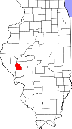
Adjacent counties:
Greene  Morgan  Pike  

Find in Illinois

Map of the Scott County area


Our detail map of Scott County shows the Scott County, Illinois boundary lines and other interesting items.

Places in Scott County, Illinois

  Airports     show all on map

Frost Airport

  Buildings     show all on map

Knox Post Light, Manchester Volunteer Fire Department, North Scott Fire Protection District, Winchester Emergency Medical Services, Winchester Volunteer Fire Department

  Cemeteries     show all on map

Adams Cemetery, Adams Family Cemetery, Adams-Hill Cemetery, Armstrong Cemetery, Baird Cemetery, Baker Cemetery, Barry Wiliam Cemetery, Batley Cemetery, Bean Cemetery, Beasley Cemetery, Berry Farm Cemetery, Bloomfield Cemetery, Borum Cemetery, Bower Cemetery, Bryant Cemetery, Burns Cemetery, Campbell Hollow Cemetery, Canatsey Cemetery, Carlton Cemetery, Claywell Cemetery, Collins Cemetery, Cowhick Cemetery, Crisp Cemetery, Davis Cemetery, Ellis Family Cemetery, Etheal Cemetery, Fairview Cemetery, Flynn Farm Cemetery, Frame Cemetery, Gillham Cemetery, Glasgow Cemetery, Graham Cemetery, Green Cemetery, Greenwalt Cemetery, Hawk Cemetery, Hayes Cemetery, Hill-Crest Cemetery, Holloway-Walker Cemetery, Jewitt Cemetery, Kellogg Cemetery, Kincaid Cemetery, Madden Cemetery, Manchester Cemetery, McCaleb Cemetery, Miller Cemetery, Mitchell Family Cemetery, Morrison Cemetery, Naples Cemetery, Neelyville Cemetery, Oak Hill Cemetery, Old Manchester Cemetery, Overton Cemetery, Oxville Township Cemetery, Parks-Robinson Cemetery, Peak Cemetery, Perkins Cemetery, Rutledge Cemetery, Saint Mark's Catholic Cemetery, Salem Cemetery, Sandridge Cemetery, Sears Cemetery, Slagle Cemetery, Smith Cemetery, Smith Cemetery, Smithson Cemetery, Taylor Cemetery, Taylor Cemetery, Trinity Lutheran Cemetery, Union Cemetery, Walker Cemetery, Wilson Cemetery, Wilson Cemetery, Wilson Cemetery, Wilson Farm Cemetery, Winchester Cemetery, Wishon Cemetery, Young Cemetery, Young E S Mac Cemetery

  Churches     show all on map

Bluffs United Methodist Church, Christ Lutheran Church, First Baptist Church, First Christian Church, Manchester Baptist Church, Oxville United Methodist Church, Pleasant Hill Church, Saint John's Lutheran Church, Saint Marks Catholic Church, Saint Patrick Catholic Church, Sandy Creek Church, Trinity Lutheran Church, Winchester Fellowship Church

  Crossings     show all on map

Interchange 52, Phillips Ferry (historical)

  Dams     show all on map

Alsey Lake Dam, Freesen Lake Dam

  Guts     show all on map

Morgan Slough

  Islands     show all on map

Big Island (historical)

  Lakes     show all on map

Burr Lake (historical), Ferry Lake, Slim Lake (historical), Smith Lake

  Locales     show all on map

Big Swan Pumping Station, Harmony Hills Campground, Scott County Poor Farm (historical)

  Mines     show all on map

Thomas Quarry

  Parks     show all on map

Ebaugh County Park, Winchester Historic District

  Populated Places     show all on map

Alsey, Bloomfield, Bluffs, Bridgeport (historical), Columbus (historical), Exeter, Geneva (historical), Glasgow, Manchester, Merritt, Naples, Oxville, Riggston, Winchester

  Post Offices     show all on map

Geneva Post Office (historical), Manchester Post Office, Riggston Post Office

  Reservoirs     show all on map

Alsey Lake, Freesen Lake

  Schools     show all on map

Akers School (historical), Big Swan School (historical), Bloomfield School (historical), Bluffdale School (historical), Bluffs High School, Brown School (historical), Burns School (historical), Campbell Hall School (historical), Carlton School (historical), Claywell School (historical), Coon Island School (historical), East Hickory School (historical), Fairview School (historical), Harts School (historical), Hazel Dell School (historical), Hickory School (historical), Independence School (historical), Kellar School (historical), Liberty School (historical), Maple Grove School (historical), McCracken School (historical), New School (historical), North College School (historical), Oak Grove School (historical), Oakdale School (historical), Pin Oak School (historical), Pleasant Hill School (historical), Pleasant Point School (historical), Ridge School (historical), Sand Ridge School (historical), School Number 108 (historical), School Number 48 (historical), Seminary School (historical), South College School (historical), Sugar Grove School (historical), Victory School (historical), West Hickory School (historical), Williams School (historical), Winchester Christian School, Winchester Elementary School, Winchester High School, Zion Neck School (historical)

  Streams     show all on map

Big Branch, Big Branch, Big Sandy Creek, Eagle Run, Little Sandy Creek, Little Sandy Creek, North Little Sandy Creek, Plum Creek, Walnut Creek, Willow Branch, Wolf Run

  Summits     show all on map

Browns Mound

  Towers     show all on map

WHBF-TV (Rock Island), WVIK-FM (Rock Island),

Scott County, Illinois Population By Race (2012 estimate)

RacePopulation
WhiteScott County White population 5,1975,197  
MixedScott County Mixed population 4242
BlackScott County Black population 2121
American IndianScott County American Indian population 1110
Hawaiian & Pacific IslanderScott County Hawaiian & Pacific Islander population 00

Additional population tables :
State population table
Illinois population by county