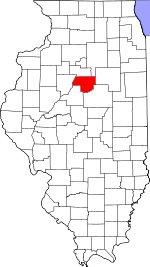
Woodford County, Illinois Basics:


Woodford County Illinois - Government Site

Population: 38,965
Area: 528 square miles
County seat: Eureka
Area code(s) in use: 309
Time zone: CST
High school graduate or higher: 93.0%
Bachelor's degree or higher: 26.3%
Median household income: $68,552
Persons in poverty: 7.4%
Home ownership rate: 82.4%
Mean travel time to work: 23.2 minutes


Adjacent counties:
La Salle  Livingston  Marshall  McLean  Peoria  Tazewell  

Find in Illinois

Map of the Woodford County area


Our detail map of Woodford County shows the Woodford County, Illinois boundary lines and other interesting items.

Places in Woodford County, Illinois

  Airports     show all on map

Barnstorm Field Airport, Corn Alley Airport, Davison RLA Airport, Janssen Airport, Jay Schertz Farm Airport, Jerry E Staab Airport, John D Rennick Airport, Michael Pfister Airport, Oltman-Shuck Airport, Scherer Landing Strip, Unzicker Airport, Wernsmans Airport

  Bridges     show all on map

Fluegel Bridge, Robenstein Bridge

  Buildings     show all on map

Benson Ambulance Service, Benson Community Fire Protection District, Congerville Fire Department, Deer Creek Fire and Rescue, El Paso City Hall, El Paso Emergency Squad, El Paso Fire Department, El Paso Public Library, Emergency 116 Ambulance Service, Eureka - Goodfield Fire Protection District Eureka Station, Eureka - Goodfield Fire Protection District Goodfield Station, Germantown Hills Community Center, Germantown Hills Fire Protection District, Germantown Hills Town Hall, Greene Township Hall, Illinois State Police-District Number Eight, Kansas Townhall, Linn Township Hall, Metamora City Hall, Metamora Courthouse, Metamora Volunteer Fire Department, Minonk Emergency Squad, Minonk Fire Protection District, Partridge Townhall, Roanoke Fire Protection District, Roanoke Municipal Ambulance Department, Secor Community Fire Protection District, Spring Bay Fire Protection District Station 1, Spring Bay Township Hall, Washburn Fire Protection District, Woodford County Courthouse, Woodford County Home

  Cemeteries     show all on map

Allison Cemetery, Apostolic Christian Cemetery, Baughman Cemetery, Bauman Cemetery, Benson Cemetery, Bigger Cemetery, Black Partridge Cemetery, Buckingham Cemetery, Carlock Oak Grove Cemetery, Carroll Cemetery, Centennial Chapel Cemetery, Church of the Brethern Cemetery, Clayton Cemetery, Clayton Township Cemetery, County Cemetery, Davison Cemetery, Dells Apostolic Christian Cemetery, East White Oak Cemetery, El Paso Cemetery, Eureka Cemetery, Gabetown Cemetery, Haedicke Cemetery, Hallenback Cemetery, Harmony Cemetery, Harper Cemetery, Hartman Cemetery, Hawks Farm Cemetery, Hickory Point Cemetery, Imhoff Cemetery, Kappa Cemetery, Linn Mount Vernon Cemetery, Lone Hill Cemetery, Lourds Cemetery, Low Point Cemetery, Lutheran Cemetery, Maurer Cemetery, Mennonite Cemetery, Mennonite Cemetery, Minonk Cemetery, Morristown Cemetery, Mount Zion Cemetery, Mount Zion Cemetery, Mount Zion Cemetery, Oak Grove Cemetery, Oakwood Cemetery, Panther Cemetery, Roanke Cemetery, Saint Elizabeth Catholic Cemetery, Saint John Cemetery, Saint Josephs Cemetery, Saint Mary's Catholic Cemetery, Saint Marys Cemetery, Saint Marys Roman Cemetery, Saint Patricks Cemetery, Saint Peter Lutheran Cemetery, Saint Peters Cemetery, Sand Ridge Cemetery, Sand Ridge Cemetery, Secor Cemetery, Spring Bay Cemetery, Stumbaugh Cemetery, Trinity Cemetery, Trinity Evangelical Lutheran Cemetery, Washburn Cemetery, White Oak Cemetery, Winkler Cemetery, Wolf Creek Cemetery, Woosley Cemetery

  Churches     show all on map

Apostolic Church, Benson Baptist Church, Brethren Church, Centennial Chapel (historical), Christ Church, Christian Union Church, Church of the Nazarene, Community Bible Fellowship of El Paso, Congerville Church, East White Oak Church, El Paso Christian Church, El Paso United Methodist Church, Faith Bible Church, First Baptist Church, First Baptist Church, Germantown Hills Baptist Church, Harvest Chapel Assembly of God Church, Immanuel Lutheran Church, Liberty Bible Church, Linn Mennonite Church, Lourdes Church, Mennonite Church, Minonk Baptist Church, Mount Alerno Novitiate, Oak Grove Church, Our Redeemer Church, Roanoke United Methodist Church, Saint Andrews Episcopal Church, Saint Johns Catholic Church, Saint Johns Lutheran Church, Saint Joseph's Catholic Church, Saint Marys Catholic Church, Saint Marys Friary, Saint Patrick Church, Saint Paul Lutheran Church, Saint Pauls United Church of Christ, Saint Peter Lutheran Church, Secor Church of Christ, Secor United Methodist Church, Trinity Lutheran Church, Trinity Lutheran Church, United Methodist Church of Minonk, Willow Hill Church

  Crossings     show all on map

Interchange 112

  Dams     show all on map

Barwell Lake Dam, Eureka Lake Dam, Evergreen Lake Dam, Izaak Walton Lake Dam, Lake Santa Fe Dam, Rich Lake Dam, Schlipf Lake Dam, Stark Pond Dam

  Hospitals     show all on map

Eureka Community Hospital

  Islands     show all on map

Chillicothe Island

  Lakes     show all on map

Izaak Walton Lake, Upper Peoria Lake, Wildwind Lake

  Locales     show all on map

Camp Manitoumi, Camp Tapawingo, Camp Wildwood, Centennial Gymnasium, Colburn Farms, Delaney Farms, El Paso Golf Club, Lone Willow Farm, Longview Farms, Pineline Farms

  Mines     show all on map

Powley Gravel Pit

  Parks     show all on map

Illinois River State Fish and Wildlife Area, Ridgetop Hill Prairie Nature Preserve, Spring Bay Fen Nature Preserve, Woodford County State Conservation Area, Woodford County State Conservation Area

  Populated Places     show all on map

Bay View Garden, Benson, Bowling Green (historical), Cazenovia, Charlottes Trailer Court, Congerville, Cruger, El Paso, Enchanted Gardens Mobile Home Park, Eureka, Farmsville (historical), Germantown Hills, Goodfield, Hickory Point, Kappa, Kilpatricks Mobile Home Park, Low Point, Mackinaw Dells, Metamora, Minonk, Oak Ridge, Panola, Roanoke, Secor, Spires, Spring Bay, Tuckaway Manor Mobile Home Park, Washburn, Woodford

  Post Offices     show all on map

Cazenovia Post Office, El Paso Post Office, Lowpoint Post Office

  Reservoirs     show all on map

Barwell Lake, Benson Water Tower, Eureka Lake, Lake Santa Fe, Rich Lake, Schlipf Lake, Stark Pond, White Oak Lake

  Schools     show all on map

Alcott School (historical), Bethel School (historical), Bluff View School, Bricktown School (historical), Centennial Elementary School, Columbia School (historical), Congerville Elementary School, Davenport Elementary School, El Paso High School, Eureka College, Eureka High School, Eureka Middle School, Fairview School (historical), Fieldcrest Elementary School-South, Fieldcrest High School, Galey School (historical), Garrison School (historical), Germantown Hills Elementary School, Germantown Hills Middle School, Glenwood School (historical), Grand View School (historical), Greeley School (historical), Happy Hour School (historical), Harmony School (historical), Harvey School (historical), Hazel Dell School (historical), Hickory Point School (historical), Hillside School, Hopewell School (historical), Jefferson Park Elementary School, Lewis School (historical), Lincoln School (historical), Lowell School (historical), Lowpoint-Washburn High School, Maple Grove School (historical), Maple Lawn School (historical), Meridian School (historical), Metamora Grade School, Metamora High School, Morristown School (historical), Mount Pleasant School (historical), North Carlock School (historical), Oak Dell School (historical), Oakenwald School (historical), Oakhill School (historical), Olio School (historical), Olive Branch School (historical), Panther Creek School (historical), Partridge School (historical), Pleasant Valley School (historical), Pleasant View School (historical), Prairie Lake School (historical), Price School (historical), Ray School (historical), Reed School (historical), Richland School (historical), Riverside School, Riverview Elementary School, Roanoke-Benson High School, Roanoke-Benson Junior High School, Rock Quarry School (historical), Saint Marys School, Saint Patricks School, Science Hill School (historical), Shepherd School (historical), Sowers Elementary School, Spring Hill School (historical), Spring Hill School (historical), Tom School (historical), Tucker School (historical), Union School (historical), Vernon School (historical), Versailles School (historical), Walnut Grove School (historical), Webster School (historical)

  Streams     show all on map

Alloway Creek, Blalock Creek, Blue Creek, Coon Creek, Denman Creek, Dry Creek, East Branch Panther Creek, Funks Run, Little Panther Creek, Mill Creek, Mundinger Creek, Olive Branch, Panther Creek, Partridge Creek, Red River, Richland Creek, Sixmile Creek, Snag Creek, Snake Creek, Vincent Run, Walnut Creek, West Branch Panther Creek, Wolf Creek, Wolf Creek

  Summits     show all on map

Nichols Mound

  Towers     show all on map

WBZM-FM (Chillicothe), WCRI-FM (Eureka), WYZZ-TV (Bloomington)

  Valleys     show all on map

Burkett Hollow,

Woodford County, Illinois Population By Race (2012 estimate)

RacePopulation
WhiteWoodford County White population 38,03038,029  
MixedWoodford County Mixed population 390389
AsianWoodford County Asian population 234233
American IndianWoodford County American Indian population 7877
Hawaiian & Pacific IslanderWoodford County Hawaiian & Pacific Islander population 00

Additional population tables :
State population table
Illinois population by county