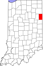
Adams County, Indiana Basics:


Adams County Indiana - Government Site

Population: 34,381
Area: 339 square miles
County seat: Decatur
Area code(s) in use: 260
Time zone: EST
High school graduate or higher: 84.5%
Bachelor's degree or higher: 14.5%
Median household income: $45,339
Persons in poverty: 16.6%
Home ownership rate: 80.1%
Mean travel time to work: 22.3 minutes


Adjacent counties:
Allen  Jay  Mercer (OH)  Van Wert (OH)  Wells  

Find in Indiana

Map of the Adams County area


Our detail map of Adams County shows the Adams County, Indiana boundary lines and other interesting items.

Places in Adams County, Indiana

  Airports     show all on map

Blomenberg Airport, Decatur Hi-Way Airport, Gage Airport, Holt Field Airport, Sprungers South Adams County Airstrip

  Bridges     show all on map

Scheiman Bridge

  Buildings     show all on map

Adams County Emergency Medical Services, Berne Fire Department, Decatur Fire Department, Geneva Volunteer Fire Department, Heller Nursery, Monroe Volunteer Fire Department, Preble Volunteer Fire Department

  Canals     show all on map

Adler Ditch, Anderson Ditch, Aspy Ditch, Ayers Ditch, Barr Ditch, Berry Ditch, Blair Ditch, Bluhm Ditch, Bracht Ditch, Brewster Ditch, Bulhman Schoder Ditch, Compro-Wittmer Ditch, Conrad Ditch, Duer Ditch, Egley Ditch, Engle Ditch, Farlow Ditch, Ferguson Ditch, Fuch Ditch, Gallmeyer Ditch, Gates Ditch, Gerber Joint Ditch, Glendenning Ditch, Habegger Ditch, Hahnert Ditch, Hendericks Ditch, Hendricks Ditch, Henschen Ditch, Hessler Ditch, Hierly Ditch, Holbrock Ditch, Holthouse Ditch, Jamstutz Ditch, Johnson Ditch, Kohne Number One Ditch, Kohne Number Two Ditch, Koos Ditch, Kutzman Ditch, Lambert Ditch, Leichty Ditch, Martz Ditch, Meyer Ditch, Miller Ditch, Moser Ditch, Norris Ditch, Ohler Ditch, Peel Ditch, Rice Ditch, Ruppert Ditch, Schugg Ditch, Selking Ditch, Shoemaker Ditch, Smith Ditch, Smith Shoemaker Ditch, Sprunger Ditch, Sullivan Ditch, Swartz Ditch, Wagner Number One Ditch, Weber Ditch, Werling Myers Ditch, Wittmer Number One Ditch, Wittmer Number Two Ditch

  Cemeteries     show all on map

Alberson Cemetery, Alpha Cemetery, Beibersteine Cemetery, Bethel Cemetery, Brown Cemetery, Bunker Hill Cemetery, Clark Chapel Cemetery, Collins Cemetery, Crawford Cemetery, Daugherty Cemetery, French Cemetery, Graber Cemetery, Greenwood Cemetery, Greenwood Cemetery, Hartford Cemetery, Hoosier Cemetery, Lufborrow Cemetery, Mazelin Cemetery, Moser Cemetery, Mount Tabor Cemetery, Old Mount Tabor Cemetery, Pleasant Valley Cemetery, Ray Cemetery, Saint Josephs Cemetery, Saint Lukes Cemetery, Salem Cemetery, Salem Cemetery, Shady Cemetery, Smith Cemetery, Snow Cemetery, Studebaker Cemetery, Tricker Cemetery, Union Chapel Cemetery, Westlawn Cemetery, Zion Cemetery

  Churches     show all on map

Antioch Church, Apple Grove Church, Bethel Church, Calvary Church, Calvary Evangelical Church, Christian Mission Church, First Missionary Church, Friends Meetinghouse, Maple Grove Church, Mount Carmel Church, Mount Hope Church, Mount Pleasant Church, Mount Victory Church, Pleasant Dale Church, Pleasant Valley Church, Saint Lukes Church, Saint Marys Church, Saint Pauls Church, Salem Church, Spring Hill Church, Union Chapel, Union Chapel, Union Church, West Missionary Church, Winchester Church

  Dams     show all on map

Meyer Lake Dam, Rainbow Lake Dam, Saddle Lake Dam

  Hospitals     show all on map

Adams Memorial Hospital

  Lakes     show all on map

Pine Lake

  Locales     show all on map

Adam's Farms, Adams County Home, Adams Swine Farms, B and R Farms, Bella Vista Farms, Erxleben Farms, Irish Acres Dairy, Lotter Farms, S and G Poultry Farm, Solid Rock Farms, Sommer Farm, South Forty Farms, Sprunger Farm, Toland Farms, Tri Oaks Farm, Workinger Farms

  Mines     show all on map

Adams County Sand and Gravel Pit, Karch Stone Quarry, Linn Grove Quarry, Pleasant Mills Quarry

  Parks     show all on map

Four-H Park, Hanna City Park, Lehman Park, Limberlost State Memorial, McMillen Park, Stratton Park

  Populated Places     show all on map

Berne, Ceylon, Coppess Corner, Decatur, Elm Tree Crossroads, Geneva, Honduras, Linn Grove, Magley, Monmouth, Monroe, Perryville, Peterson, Pleasant Mills, Preble, Rivare, Salem, Williams

  Reservoirs     show all on map

Meyer Lake, Rainbow Lake, Saddle Lake

  Schools     show all on map

Adams Central Elementary School, Adams Central High School, Adams Central Middle School, Berne Elementary School, Blue Creek Amish School, Geneva Elementary School, Immanuel School, Jefferson School, Kirkland Bible Institute, Lincoln Amish School Number Two, Northwest Elementary School, Saint Johns School, Saint Josephs School, Saint Pauls School, Saint Peter-Immanuel Lutheran School, Southeast Elementary School, Zion Lutheran School

  Streams     show all on map

Borum Run, Limberlost Creek, Little Blue Creek, Martz Creek, Ohler Branch, Straight Branch, Twentyseven Mile Creek, Yellow Creek

  Towers     show all on map

WADM-AM (Decatur), WADM-FM (Decatur),

Adams County, Indiana Population By Race (2012 estimate)

RacePopulation
WhiteAdams County White population 33,79733,796  
MixedAdams County Mixed population 241240
BlackAdams County Black population 138137
American IndianAdams County American Indian population 103103
Hawaiian & Pacific IslanderAdams County Hawaiian & Pacific Islander population 00

Additional population tables :
State population table
Indiana population by county