Blackford County, Indiana Basics:


Blackford County Indiana - Government Site

Population: 12,554
Area: 165 square miles
County seat: Hartford City
Area code(s) in use: 765
Time zone: EST
High school graduate or higher: 86.1%
Bachelor's degree or higher: 10.0%
Median household income: $39,619
Persons in poverty: 16.5%
Home ownership rate: 75.1%
Mean travel time to work: 25.6 minutes

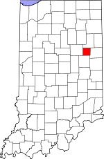
Adjacent counties:
Delaware  Grant  Jay  Wells  

Find in Indiana

Map of the Blackford County area


Our detail map of Blackford County shows the Blackford County, Indiana boundary lines and other interesting items.

Places in Blackford County, Indiana

  Airports     show all on map

Hickory Hills Airport, Hoovers Airport, Inman Airport, Minneman Airport, Smith Field Airport

  Buildings     show all on map

Hartford City Fire Department, Montpelier - Harrison Township Volunteer Fire Department Station 1, Montpelier - Harrison Township Volunteer Fire Department Station 2, Northside Greenhouse

  Canals     show all on map

Allman Ditch, Bugh Ditch, Burchard Foreman Ditch, Casterline Forkner Ditch, Chaney Ditch, Dutro Ditch, Fiddler Ditch, Fulkerson Ditch, Gieger Ditch, Gillespie Ditch, Greenlee Ditch, Groff Ditch, Gronendyke Ditch, Haag Ditch, Hawkins Ditch, Hickman Ditch, Hudson Ditch, Huggens Ditch, Jones Ditch, Kelly Ditch, Landon Ditch, Lemuel Ditch, McGeath Ditch, McMammon Ditch, Rhoton Ditch, Rinard Prong, Schwartzkopf Ditch, Shinn Ditch, Simonton Ditch, Skinner Ditch, Slocum Ditch, Townsand Lucas Ditch, Twomile Ditch, Tyner Ditch, Wentz Ditch, Whipple Ditch, White Hoover Ditch, Whitecotton Ditch

  Cemeteries     show all on map

Balsley Cemetery, Center Cemetery, Independent Order of Odd Fellows Cemetery, Independent Order of Odd Fellows Cemetery, Leffler Cemetery, Lion Cemetery, Mills Cemetery, Mount Tablor Cemetery, Odd Fellows Cemetery, Personett Cemetery, Shields Cemetery, Stoll Cemetery, Twibell Cemetery, Wayman Cemetery, Willman Cemetery, Woodlawn Cemetery

  Churches     show all on map

Bethel Center Church, Bethel Church, Fairview Church, Highway Bible Church, Independence Church, Kingsley Church, Mount Carmel Church, Olive Branch Church, Pleasant Dale Church, Pleasant Grove Church, Union Center Church, Union Church

  Dams     show all on map

Lake Mohee Dam

  Hospitals     show all on map

Blackford Community Hospital

  Lakes     show all on map

Cains Lake, Lake Blue Water

  Locales     show all on map

Oswalt Hog Farm

  Mines     show all on map

Erie Stone Quarry

  Populated Places     show all on map

Converse, Hartford City, Hoover Park, Matamoras, Millgrove, Montpelier, Renner, Roll, Shamrock Lakes, Trenton

  Reservoirs     show all on map

Lake Mohee, Lake Placid

  Schools     show all on map

Blackford High School, Dildine School, Montpelier Elementary School, Parkside Elementary School, Southside Elementary School, William Reed Elementary School

  Streams     show all on map

Belt Run, DeBatty Prong, East Creek, Little Joe Creek, Little Lick Creek, Moore Prong, Olive Branch, Priam Run, Salamonie River

  Towers     show all on map

WWHC-FM (Hartford City),

Blackford County, Indiana Population By Race (2012 estimate)

RacePopulation
WhiteBlackford County White population 12,25312,252  
MixedBlackford County Mixed population 163163
BlackBlackford County Black population 7575
American IndianBlackford County American Indian population 2525
Hawaiian & Pacific IslanderBlackford County Hawaiian & Pacific Islander population 00

Additional population tables :
State population table
Indiana population by county