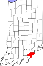
Clark County, Indiana Basics:


Clark County Indiana - Government Site

Population: 111,972
Area: 373 square miles
County seat: Jeffersonville
Area code(s) in use: 812
Time zone: EST
High school graduate or higher: 86.1%
Bachelor's degree or higher: 18.6%
Median household income: $50,559
Persons in poverty: 12.2%
Home ownership rate: 71.5%
Mean travel time to work: 23.5 minutes


Adjacent counties:
Floyd  Jefferson  Jefferson (KY)  Oldham (KY)  Scott  Trimble (KY)  Washington  

Find in Indiana

Map of the Clark County area


Our detail map of Clark County shows the Clark County, Indiana boundary lines and other interesting items.

Places in Clark County, Indiana

  Airports     show all on map

Clark Regional Airport, Haps Airport, Holloway Field Airport

  Basins     show all on map

Carters Hole

  Bridges     show all on map

Big Four Bridge, John F Kennedy Memorial Bridge

  Buildings     show all on map

Borden - Wood Township Fire Department, Borden Wood Township Volunteer Fire Department, Charlestown Fire Department Station 1, Charlestown Fire Department Station 2, Charlestown Fire Department Station 3, Charlestown Fire Department Station 4, Clarksville Fire Department Station 1, Clarksville Fire Department Station 2, Clarksville Fire Department Station 3, Graf's Greenhouse, Jeffersonville City Fire Department, Jeffersonville City Fire Department Station 2 Headquarters, Jeffersonville City Fire Department Station 3, Jeffersonville Fire Department, Jeffersonville Fire Department Station 1, Jeffersonville Fire Department Station 2, McCulloch Volunteer Fire Department, Monroe Township Fire Department, Monroe Township Volunteer Fire Department Station 2, Monroe Township Volunteer Fire Department Station 3, New Chapel Emergency Medical Services, New Washington Fire Department, New Washington Fire Department, New Washington Fire Department, New Washington Volunteer Fire Department, Sellersburg Fire Department Station 2, Sellersburg Fire Department Station 4, Sellersburg Volunteer Fire Department Station 1, Sellersburg Volunteer Fire Department Station 3, Sellersburg Volunteer Fire Department Station 5, Utica Township Volunteer Fire Department Station 1, Utica Township Volunteer Fire Department Station 2, Wellstone Regional Hospital

  Cemeteries     show all on map

Adams Cemetery, Allen Cemetery, Barnes Cemetery, Bottoff Cemetery, Bowery Cemetery, Crown Hill Cemetery, Dailey Cemetery, Eastern Cemetery, Fifty-four Cemetery, Hendrick Cemetery, Hickory Grove Cemetery, Kern Cemetery, Long Cemetery, Miller Cemetery, Mount Zion Cemetery, Mountain Grove Cemetery, Olive Branch Cemetery, Pleasant Grove Cemetery, Pleasant Ridge Cemetery, Robinson Cemetery, Saint Anthonys Cemetery, Saint Michaels Cemetery, Seedtick Cemetery, Smith Cemetery, States Cemetery, Turner Cemetery, Union Cemetery, Walnut Hill Cemetery, Walnut Ridge Cemetery, Worrell Cemetery

  Census     show all on map

Henryville Census Designated Place, Memphis Census Designated Place, New Washington Census Designated Place, Oak Park Census Designated Place

  Churches     show all on map

Asbury Chapel, Bethany Church, Bethel Church, Blue Lick Church, Daisy Hill Church, Eastern Hights Chapel, Emmanuel Church, Faith Church, Hebron Church, Lear Hill Church, Mount Lebanon Church, Mount Moriah Church, New Chapel, Northside Church, Oak Park Church, Owen Creek Church, Park Place Church, Pleasant Grove Church, Pleasant View Church, Rolling Fields Church, Salem Church, Silver Creek Church, Stony Point Church, Willys Chapel

  Dams     show all on map

Country Lake Camp Dam, Dream Lake Dam, Franke Lake Dam, Jack Pine Park Lake Dam, Lake Hideaway Dam, Muddy Fork Number 2 Dam, Schlamm Lake Dam, Shady Hollow Lake Dam, Southern Hills Lake Dam, Stumbler Lake Dam

  Falls     show all on map

Falls of the Ohio

  Hospitals     show all on map

Clark Memorial Hospital, Saint Catherine Regional Hospital

  Islands     show all on map

Rose Island

  Lakes     show all on map

Brick House Pond, Silver Lakes

  Locales     show all on map

Blooms Eddy (historical), Charlestown Landing, Elks Country Club, Green Tree Mall, Greentree Mall Shopping Center, Hughes Station, Jay C Shopping Center, King Landing, Mound Builders Fort (historical), Pattersons Landing, Pulltight, River Falls Mall, River Falls Mall Shopping Center, Silver Creek Conservation Club, Trader Baker Mall, White Oak Public Fishing Area, Wooded View Country Club

  Mines     show all on map

Copperas Banks (historical), Sellersburg Stone Quarry, Speed Quarry

  Parks     show all on map

Atlantis Water Park, Camp Chelan, Camp Honor Bright, Colgate Park, Deam Lake State Recreation Area, Falls of the Ohio State Park, Lapping Memorial Park, Lawrence Park, Memorial Park, River City Park, Sylvan Park, Tunnel Mill Boy Scout Camp, Tunnel Mill Camp, Van Dyke Park, Wathen Park

  Populated Places     show all on map

Arctic Springs, Bennettsville, Bethlehem, Blackiston Village, Blue Lick, Borden, Broom Hill, Carwood, Cementville, Charlestown, Chestnut Hill, Clark Siding, Clarksville, Germany, Graysville, Hamburg, Henryville, Hibernia, Jeffersonville, Longview Beach, Marysville, Memphis, Miles Point, New Liberty, New Market, New Washington, Oak Park, Otisco, Otto, Owen, Perry Crossing, Port Fulton, Prather, River Ridge, Rolling Hills, Runyantown, Sellersburg, Slatecut, Speed, Springville, Starlight, Sunset Village, Sylvan Grove, Underwood, Utica, Vesta, Watson, Wilson

  Post Offices     show all on map

Charlestown Post Office, Jeffersonville Post Office, Memphis Post Office, Polk Run Post Office (historical), Pulltight Post Office (historical), Sellersburg Post Office

  Rapidss     show all on map

Blooms Eddy (historical)

  Reservoirs     show all on map

Big Bass Lake, Country Lake, Deam Lake, Dream Lake, Franke Lake, Jack Pine Park Lake, Lake Hideaway, Lake Joyce, Oak Lake, Pine Lake, Schlamm Lake, Scottsville Lake, Shady Hollow Lake, Stumbler Lake

  Ridges     show all on map

Bartle Knobs, Devils Backbone, Waggoner Knobs

  Schools     show all on map

Bridgepoint Elementary School, Charlestown Senior High School, Clarksville Middle School, Clarksville Senior High School, Clegg School, Colgate School, Corden Porter Education Center, Eastlawn Elementary School, Ewing Lane Elementary School, George Rogers Clark Elementary School, Greenacres Elementary School, Henryville Elementary School, Henryville Junior and Senior High School, Indiana University Center, IVY Technological Community College of Southern Indiana, Jeffersonville High School, Maple Elementary School, McCulloch Elementary School, Memphis Elementary School, Middle Road School, Northaven Elementary School, Ottawa University Indiana Campus, Our Lady of Providence High School, Parkview Junior High School, Parkwood Elementary School, Pleasant Ridge Elementary School, Purdue University Forestry Camp, Riverside Elementary School, Rose Hill Elementary School, Sacred Heart of Jesus School, Saint Anthony School, Saint John Elementary School, Saint Michael School, Silver Creek High School, Silver Creek Junior High School, Spring Hill Elementary School, Stout Elementary School, Thomas Jefferson Elementary School, Utica School, W E Wilson Elementary School, William W Borden Elementary School, William W Borden High School

  Streams     show all on map

Anson Branch, Bartle Knob Run, Battle Creek, Berry Run, Big Branch, Big Drain, Big Run, Big Rusty Gut, Blue Lick Creek, Bowery Creek, Bright Run, Bull Creek, Bull Run, Calf Run, Camp Run, Cane Run, Caney Fork, Carr Peyton Branch, Cave Run, Clegg Creek, Collins Run, Cow Run, Dry Branch, Dry Fork, East Fork Fourteenmile Creek, Fishing Run, Flag Run, Fordyce Brook, Fourteenmile Creek, Grain Run, Guernsey Creek, Hall Run, Henry Brook, Henthorn Branch, Hilltop Run, Jenny Lind Run, Kelly Branch, Knob Creek, Lancassange Creek, Left Branch Blue Lick Creek, Left Drain, Lentzier Creek, Lick Creek, Lick Run, Little Battle Creek, Little Camp Creek, Little Rusty Gut, Lodge Creek, McCormick Brook, Meal Run, Milk Brook, Mill Branch, Mill Creek, Miller Fork, Mountain Grove, Muddy Fork, Nine Penny Branch, Out Brook, Owen Creek, Packwood Branch, Persimmon Run, Pleasant Run, Polk Run, Rain Run, Right Branch Blue Lick Creek, Right Drain, Rogers Run, Sheep Branch, Sinking Fork, Souders Branch, Squaw Creek, Sticky Branch, Stone Branch, Sugar Run, Thomas Branch, Try Run, Turkey Run, Underwood Drain, Vote Run, Weed Run, West Fork Silver Creek, Wheel Run, Wolf Run, Wrong Branch, Yankee Creek

  Summits     show all on map

Cubby House Hill, Daisy Hill, Hounds Leap, Pine Knob, Round Knob, Saint Joseph Hill

  Towers     show all on map

Nabb Radio Range Station, WDGS-AM (New Albany)

  Valleys     show all on map

Alum Cave Hollow, Breedlove Hollow, Brown Hollow, Burns Hollow, Dodson Hollow, Doolittle Hollow, Gibson Hollow, Hog Hollow, Ketter Hollow, Koetter Hollow, Mill Hollow, Money Hollow, Rabbit Hollow, Salt Well Hollow, Scott Hollow, Sugar Camp Hollow, Whitson Hollow,

Clark County, Indiana Population By Race (2012 estimate)

RacePopulation
WhiteClark County White population 99,87999,879  
BlackClark County Black population 8,1748,173
MixedClark County Mixed population 2,3512,351
AsianClark County Asian population 1,1201,119
American IndianClark County American Indian population 448447
Hawaiian & Pacific IslanderClark County Hawaiian & Pacific Islander population 112111

Additional population tables :
State population table
Indiana population by county