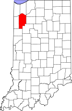
Jasper County, Indiana Basics:


Jasper County Indiana - Government Site

Population: 33,442
Area: 560 square miles
County seat: Rensselaer
Area code(s) in use: 219
Time zone: CST
High school graduate or higher: 87.8%
Bachelor's degree or higher: 14.5%
Median household income: $57,801
Persons in poverty: 8.4%
Home ownership rate: 78.4%
Mean travel time to work: 27.9 minutes


Adjacent counties:
Benton  Lake  Newton  Porter  Pulaski  Starke  White  

Find in Indiana

Map of the Jasper County area


Our detail map of Jasper County shows the Jasper County, Indiana boundary lines and other interesting items.

Places in Jasper County, Indiana

  Airports     show all on map

Alley Oop Airport, Antonian Airport, Borntraeger Airstrip, Cheever Airport, Culp Farms Airport, DeMotte Airport, Flying J Airport, Gilmore Airport, James Airport, Jasper County Airport

  Buildings     show all on map

Henning's Greenhouses, Keener Township Emergency Medical Services, Keener Township Volunteer Fire Department, Keeney Ambulance and Transport Service, Kingma Greenhouses, Remington City Fire Department, Rensselaer Volunteer Fire Department, Southern Jasper County Ambulance Service, Walstra's Greenhouse, Wheatfield Ambulance Service, Wheatfield Fire Department

  Canals     show all on map

Armstrong Ditch, Bailey Ditch, Bice Ditch, Biddle Ditch, Bosma Ditch, Boyle Ditch, Bradbury Ditch, Bruner Ditch, Callahan Ditch, Cavendish Ditch, Charles May Ditch, Chris Salrin Lateral, Claude May Ditch, Cook Ditch, Davis Ditch, Davis Ditch, Davis Ditch, Davison Ditch, Dehaan Ditch, Dexter Ditch, Evers Ditch, Fisher Ditch, Folger Ditch, Gehring and Gumz Ditch, Gehring Ditch, Gifford Ditch, Grant Ditch, Griggs Ditch, Griggs Lateral, Guild Lateral, Gushwa Ditch, Ham Lateral, Heilsher Ditch, Hershman Arm, Hickam Lateral, Hinshaw Ditch, Hobbs Ditch, Hodge Ditch, Hunter Ditch, Iliff Slough Lateral, James Ditch, James Ditch, Jordan Ditch, Joseph Salrin Arm, Jungles Ditch, Keefe Ditch, Kirkpatrick Ditch, Krucek Ditch, Lateral Number Seventy-seven, Makeever Huff Ditch, Marble Ditch, Meade Rayburn Arm, Moody Lateral, Moore Ditch, Myers Ditch, Mylius Ditch, Nesius Ditch, Newland Ditch, Oliver Ditch, Otis Ditch, Otis Ditch, Prouty Ditch, Pullin Ditch, Randle Lateral, Rassmussen Ditch, Record Lateral, Rich Grove Lateral, Ringeisen Ditch, Rockwell Ditch, Rowan Ditch, Rufus Rayburn Arm, Ryan Kraisinger Ditch, Sage Ditch, Sands Ditch, Sargent Ditch, Schatzley Ditch, Schlatzley Ditch, Schrader Ditch, Simonin Ditch, Smallfelt Ditch, Spurgeon Ditch, Stalbaum Hershman Ditch, Stover Ditch, Stump Slough Ditch, Thompson Ditch, Tyler Ditch, Tyler Ditch, Vanatta Lateral, Vernigor Ditch, Washburn Lateral, Wesner Ditch, William Hershman Lateral, Wynkoop Ditch, Yeoman Ditch, Zick Ditch

  Cemeteries     show all on map

Brown Cemetery, Burr Oak Cemetery, Cemetery of the Reesurrection, Crockett Cemetery, DeMotte Cemetery, Dunkard Cemetery, Hankle Cemetery, Hershman Cemetery, Holland Cemetery, Kniman Cemetery, Lefler Cemetery, Lutheran Cemetery, Mason Cemetery, Memory Gardens Cemetery, Milroy Cemetery, Mount Calvary Cemetery, Old Settlers Cemetery, Osborne Cemetery, Parkison Cemetery, Prater Cemetery, Price Cemetery, Rees Cemetery, Remington Cemetery, Robinson Cemetery, Sacred Heart Cemetery, Sandridge Cemetery, Smith Cemetery, Welsh Cemetery, Weston Cemetery, Yeoman Cemetery

  Census     show all on map

Collegeville Census Designated Place

  Churches     show all on map

Abundant Life Family Church, Barkley Church, Bethany Church, Bethel Christian Reformed Church, Brushwood Church, Burr Oak Church, Calvary Evangelical Free Church, Church of Christ, DeMotte Christian Church, First Baptist Church, First Christian Reformed Church, First Reformed Church, Independence Church, Kankakee Valley Bible Baptist Church, Oak Grove Church, Saint Cecilia Catholic Church, Saint Johns Church, Saint Lukes Church, Saint Peters Church, United Methodist Church, United Pentecostal Church, Zion Church

  Hospitals     show all on map

Jasper County Hospital

  Lakes     show all on map

Lake Holiday

  Locales     show all on map

Eylander Hog Farms, Foxhill Hog Farm, Shady Pines Golf Course

  Mines     show all on map

Babcock Quarry

  Parks     show all on map

Brook Side Park, Freedom Park, Spencer Park

  Populated Places     show all on map

Aix, Asphaltum, Baileys Corner, Collegeville, Deer Park, DeMotte, Dunns Bridge, Egypt, Fair Oaks, Forest City, Fountain Park, Gifford, Hanging Grove, Kersey, Kniman, Laura, Lewiston, McCoysburg, Moffitt, Moody, Newland, North Marion, Parr, Pleasant Ridge, Remington, Rensselaer, Rosebud, South Marion, Stoutsburg, Surrey, Tefft, Virgie, Wheatfield, Zadoc (historical)

  Schools     show all on map

DeMotte Christian School, Demotte Elementary School, Jordan School, Monnett Elementary School, North Newton School, Rensselaer Central High School, Saint Augustine School, Saint Josephs College, Van Rensselaer Elementary School

  Streams     show all on map

Carpenter Creek, Delehanty Ditch, Jersey Park Creek, Wolf Creek

  Towers     show all on map

WJCK-FM (Rensselaer), WPUM-FM (Rensselaer), WRIN-AM (Rensselaer),

Jasper County, Indiana Population By Race (2012 estimate)

RacePopulation
WhiteJasper County White population 32,57332,572  
MixedJasper County Mixed population 334334
BlackJasper County Black population 268267
AsianJasper County Asian population 134133
American IndianJasper County American Indian population 100100
Hawaiian & Pacific IslanderJasper County Hawaiian & Pacific Islander population 00

Additional population tables :
State population table
Indiana population by county