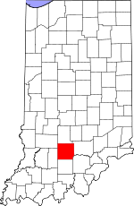
Lawrence County, Indiana Basics:


Lawrence County Indiana - Government Site

Population: 46,062
Area: 449 square miles
County seat: Bedford
Area code(s) in use: 812
Time zone: EST
High school graduate or higher: 83.0%
Bachelor's degree or higher: 12.9%
Median household income: $41,600
Persons in poverty: 16.6%
Home ownership rate: 78.2%
Mean travel time to work: 25.6 minutes


Adjacent counties:
Greene  Jackson  Martin  Monroe  Orange  Washington  

Find in Indiana

Map of the Lawrence County area


Our detail map of Lawrence County shows the Lawrence County, Indiana boundary lines and other interesting items.

Places in Lawrence County, Indiana

  Airports     show all on map

Virgil I Grissom Municipal Airport

  Basins     show all on map

Connelly Cave

  Bends     show all on map

Gyger Bend, Horseshoe Bend

  Bridges     show all on map

Stumphole Bridge, Williams Bridge

  Buildings     show all on map

Bedford Fire Department Central Station, Bedford Fire Department Englewood Station, Bedford Fire Department Station 1, Bedford Fire Department Station 2, Bedford Fire Department Station 3, Guthrie Township Volunteer Fire Department Station 1, Guthrie Township Volunteer Fire Department Station 2, Huron Volunteer Fire Department, Indian Creek Volunteer Fire Department, Marion Township Rural Fire Department, Marshall Township Volunteer Fire Department and Emergency Medical Services, Mitchell Fire Department Station 1, Mitchell Fire Department Station 2, Oolitic Volunteer Fire Department, Perry Township Volunteer Fire and Emergency Medical Services, Pleasant Run Volunteer Fire Department, Shawswick Township Volunteer Fire Department Station 4, Shawswick Volunteer Fire Department Station 1, Shawswick Volunteer Fire Department Station 2, Shawswick Volunteer Fire Department Station 3, Shawswick Volunteer Fire Department Station 4, Williams Volunteer Fire Department

  Cemeteries     show all on map

Anderson Cemetery, Bailey Cemetery, Bass Cemetery, Beech Grove Cemetery, Boone Cemetery, Breckinridge Cemetery, Bridge Cemetery, Brinegar Cemetery, Brunner Cemetery, Burton Cemetery, Burton Cemetery, Byers Cemetery, Carlton Cemetery, Christian Cemetery, Connelly Cemetery, Covey Cemetery, Cox Cemetery, Crawford Cemetery, Crest Haven Cemetery, Dodd Cemetery, Erwin Cemetery, Faubion Cemetery, Ferguson Cemetery, Freedom Cemetery, Georgia Cemetery, Graves Cemetery, Green Hill Cemetery, Grodey Cemetery, Hall Cemetery, Hamer Cemetery, Hawkins Cemetery, Hayes Cemetery, Hopkins Cemetery, Huron Cemetery, Ikerd Cemetery, Isom Cemetery, Knott Cemetery, Lowder Cemetery, Mount Zion Cemetery, Old Union Church Cemetery, Perkins Cemetery, Pleasant Hill Cemetery, Red Cross Cemetery, Scoggan Cemetery, Sheeks Cemetery, Sherril Cemetery, Starr Cemetery, Talbott Cemetery, Tanksley Cemetery, Thomason Cemetery, Tincher Cemetery, Waggner Cemetery

  Census     show all on map

Avoca Census Designated Place, Williams Census Designated Place

  Churches     show all on map

Breeze Hill Church, Dixon Chapel, Donica Memorial Church, Fairview Church, Fairview Church, Fishing Creek Chapel, Fort Williams Church, Gil Gal Church, Guthrie Creek Church, Hickory Grove Church, Hill Top Church, Indian Creek Church, Leatherwood Church, Liberty Church, Mount Olive Church, Mount Pleasant Church, Mount Pleasant Church, Mundell Church, New Union Church, Oak Grove Church, Old Union Church, Pleasant Run Church, Pleasant View Church, Ramsey Ridge Church, Shiloh Church, Spice Valley Church, The Meadows Church, Trinity Church, Valley Mission Church, Wesley Chapel

  Dams     show all on map

Ken-Ray Lake Dam, Spring Mall Park Lake Dam, Williams Dam

  Hospitals     show all on map

Bedford Regional Medical Center, Dunn Memorial Hospital

  Lakes     show all on map

Half Moon Lake, Hickory Grove Pond, Me Pike Pond, Sheeks Lake, Tincher Lake

  Locales     show all on map

4-H Club Fairground, Holiday Drive-In, Mitchell Speedway, Purdue Experimental Orchard

  Mines     show all on map

Bedford Quarry, Evans Quarry, Guthrie Quarry, Johnson Quarry, McShain Quarry, P M and B Quarry, Pearson Kaolin Mines, Sieboldt Quarry

  Parks     show all on map

Bedford Christian Camp, Bishop Roberts Park, Camp Indi-Co-So, Dickinson Park, Furst Park, Indian Creek Camp, Otis Park, Spring Mill State Park, Thornton Park, Williams Dam Public Fishing Area, Wilson Park

  Populated Places     show all on map

Avoca, Bartlettsville, Bedford, Bono, Bryantsville, Buddha, Coveyville, Coxton, Crawford, Dark Hollow, East Oolitic, Englewood, Erie, Eureka, Fayetteville, Fort Ritner, Georgia, Guthrie, Hartleyville, Heltonville, Huron, Judah, Lawrenceport, Leesville, Logan, Mitchell, Moorestown, Murdock, Needmore, Oolitic, Patton Hill, Peerless, Pinhook, Popcorn, Rabbitville, Red Hill, Redding, Rivervale, Riverview, Shawswick, Silverville, Spring Mill Village, Springville, Stemm, Stonington, Tarry Park, Thornton, Tunnelton, Williams, Woodville, Yockey, Zelma

  Rapidss     show all on map

Chase Ripple

  Reservoirs     show all on map

Ken-Ray Lake, Rainbow Lake, Spring Mall Park Lake

  Ridges     show all on map

Bosler Ridge, Burton Ridge, Dennison Ridge, Devils Backbone, Ditney Ridge, Grodey Ridge, Mitchell Ridge, Ramsey Ridge, Toliver Ridge

  Schools     show all on map

Bedford-North Lawrence High School, Burris Elementary School, Dive School, Dollens Elementary School, Heltonville Elementary School, Huron Elementary School, Lincoln Elementary School, Mitchell High School, Needmore Elementary School, Oolitic Junior High School, Parkview Intermediate School, Pleasant Run Township School, Purdue University Experimental Farm, Saint Vincent Depaul School, Shawswick Elementary and Junior High School, Springville Elementary School, Stalker Elementary School, Water Madden School

  Streams     show all on map

Adamson Branch, Back Creek, Bailey Branch, Bowlen Branch, Brannaman Branch, Brewer Branch, Chapman Creek, Crawford Creek, DeWitt Creek, Dry Branch, Dry Creek, Goose Creek, Gulletts Creek, Guthrie Creek, Henderson Creek, Hooper Creek, Howe Creek, Hunter Creek, Jackie Branch, Leatherwood Creek, McPike Branch, Mill Creek, Pleasant Run, Rock Lick Branch, South Fork Crawford Creek, South Fork Leatherwood Creek, Spider Creek, Spring Creek, Starnes Branch, Terrill Branch

  Summits     show all on map

Gobblers Knob, Haystack Rocks, Mall Hill, Rariden Hill, Red Hill, Sally Hill, Tunnel Hill

  Towers     show all on map

WBIF-FM (Bedford), WBIW-AM (Bedford)

  Valleys     show all on map

Burton Hollow, Dark Hollow, Diehl Hollow, Hert Hollow, Hog Hollow, Jones Defeat Hollow, Landreth Hollow, Linden Hollow, Sipes Hollow, Speed Hollow, Tincher Hollow,

Lawrence County, Indiana Population By Race (2012 estimate)

RacePopulation
WhiteLawrence County White population 44,95744,956  
MixedLawrence County Mixed population 507506
AsianLawrence County Asian population 230230
American IndianLawrence County American Indian population 184184
Hawaiian & Pacific IslanderLawrence County Hawaiian & Pacific Islander population 00

Additional population tables :
State population table
Indiana population by county