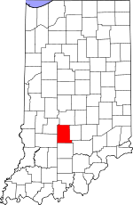
Monroe County, Indiana Basics:


Monroe County Indiana - Government Site

Population: 141,255
Area: 395 square miles
County seat: Bloomington
Area code(s) in use: 812
Time zone: EST
High school graduate or higher: 91.8%
Bachelor's degree or higher: 43.3%
Median household income: $38,675
Persons in poverty: 25.0%
Home ownership rate: 54.2%
Mean travel time to work: 18.3 minutes


Adjacent counties:
Brown  Greene  Jackson  Lawrence  Morgan  Owen  

Find in Indiana

Map of the Monroe County area


Our detail map of Monroe County shows the Monroe County, Indiana boundary lines and other interesting items.

Places in Monroe County, Indiana

  Airports     show all on map

Lake Monroe Airport, Monroe County Airport

  Buildings     show all on map

Bean Blossom - Stinesville Fire Department, Bean Blossom Township - Stinesville Fire Department, Benton Township Volunteer Fire, Benton Township Volunteer Fire Department, Bloomington Fire Department, Bloomington Fire Department Station 1, Bloomington Fire Department Station 2, Bloomington Fire Department Station 3, Bloomington Fire Department Station 4, Bloomington Fire Department Station 5, Bloomington Township Department of Fire and Rescue Station 15, Bloomington Township Department of Fire and Rescue Station 5 Headquarters, Bloomington Township Fire Department Station 15, Bloomington Township Fire Department Station 5, Ellettsville Fire Department Station 7, Ellettsville Fire Department Station 8, Indian Creek Volunteer Firefighters, Indiana Department of Natural Resources - Division of Forestry Fire Control Headquarters, Mays Greenhouse, Meadows Hospital, Perry - Clear Creek Fire Department Station 11, Perry - Clear Creek Fire Department Station 21, Van Buren Township Fire Department Station 19, Van Buren Township Fire Department Station 9

  Capes     show all on map

Reed Point, Riddle Point

  Cemeteries     show all on map

Burgoon Church, Chambers Cemetery, Clover Hill Cemetery, Coffey Cemetery, Collier Cemetery, Dowell Cemetery, Elliott Cemetery, Friendship Cemetery, Hanson Cemetery, Harmony Cemetery, Hillenburg Cemetery, Keller Cemetery, King Cemetery, Lucas Cemetery, Mitchell Cemetery, Mount Carmel Cemetery, Mount Salem Cemetery, Perry Cemetery, Rose Hill Cemetery, Sample Cemetery, Shiloh Cemetery, Stepp Cemetery, Taylor Cemetery, Todd Cemetery, Valhalla Memory Gardens, Van Buskirk Cemetery, Whitehall Cemetery

  Census     show all on map

Harrodsburg Census Designated Place, Smithville-Sanders Census Designated Place

  Churches     show all on map

Bethel Church, Bethel Lane Church, Blackwell Church, Bridge Church, Brummett Creek Church, Buenavista Church, Chafin Memorial Church, Crossroads Church, Deelsville Church, Dolan Ridge Mission, Faith Church, Friendship Church, Garrison Chapel, Harmony Church, Hebron Church, Hunter Creek Church, Liberty Church, Linthieum Church, Little Union Church, Locust Grove Church, Maple Grove Christian Church, Mount Calvary Church, Mount Ebal Church, Mount Gilead Church, Mount Olive Church, Mount Pleasant Church, Mount Zion Church, New Paynetown Church, New Prospect Church, Old Dutch Church, Pine Grove Church, Richland Church, Saint Marks Church, Saint Pauls Church, Shiloh Temple, Simpson Church, South Side Church, South Union Church, Stewart Tabernacle, Walkers Chapel

  Cliffs     show all on map

Cedar Cliffs, Crum Point, Kelly Point

  Dams     show all on map

Bean Blossom Dam, Bethal Lake Dam, Bryant Creek Lake Dam, Cherry Lake Dam, Egenolf Lake Dam, Gritty Reservoir Dam, Henke Lake Dam, Lazy Lake Dam, Monroe Lake Dam, Schacht Lake Dam, University Lake Dam, Weimer Lake Dam

  Forests     show all on map

Morgan-Monroe State Forest

  Gaps     show all on map

Low Gap

  Hospitals     show all on map

Bloomington Hospital, Bloomington Meadows Hospital, Monroe Hospital

  Islands     show all on map

Cemetery Island

  Lakes     show all on map

Dutch Ridge Lake, Geiger Ridge Pond, Hunter Creek Pond, Jay Pond, Twin Lakes

  Locales     show all on map

Blackwell Pond Campground, Bloomington Speedway, College Mall Shopping Center, Hardin Ridge Recreation Site, Indiana University Stadium, Ransburg Boy Scout Reservation, Scout Ridge Youth Campground, Starlite Drive-In, Wheeler Mission Campground

  Mines     show all on map

Bloomington Quarry, Hunter Valley Quarry, Maple Hill Quarry, Woolery Stone Quarry

  Parks     show all on map

Allens Creek State Recreation Area, Bryan Park, Camp Wapehani, Cascade Park, Fairfax State Recreation Area, Hardin Ridge Recreation Area, Mason Ridge Camping Area, North Fork State Wildlife Refuge, Oak Ridge Camping Area, Paynetown State Recreation Area

  Populated Places     show all on map

Arlington, Bloomington, Broadview, Buenavista, Cascade, Chapel Hill, Clear Creek, Dolan, Eastern Heights, Ellettsville, Elwren, Fairfax, Fleener, Forest Park Heights, Garden Acres, Handy, Harrodsburg, Highland Village, Hindustan, Hoosier Acres, Hunter Switch, Kirby, Kirksville, Knight Ridge, Lancaster Park, Leonard Springs, Marlin Hills, Modesto, Mount Tabor, New Unionville, Ridgemede, Sanders, Smithville, Stanford, Stinesville, Sunny Slopes, Unionville, Van Buren Park, Victor, Wayport, West Brook Downs, Woodville Hills, Yellowstone

  Post Offices     show all on map

Allens Creek Post Office (historical), South Granger Post Office (historical)

  Reserves     show all on map

Charles C. Deam Wilderness, Scout Ridge Nature Reserve

  Reservoirs     show all on map

Beanblossom Lake, Bethal Lake, Blackwell Lake, Bryant Creek Lake, Cherry Lake, Egenolf Lake, Griffy Reservoir, Henke Lake, Lake Lemon, Lazy Lake, Monroe Lake, Schact Lake, Tower Blackwell Lake, University Lake, Weimer Lake

  Ridges     show all on map

Bender Ridge, Brown Ridge, Devils Backbone, Dutch Ridge, Epsom Ridge, Farr Ridge, Ferris Ridge, Frank Grubb Ridge, Frog Pond Ridge, Gorley Ridge, Hardin Ridge, Holland Ridge, Howard Ridge, Ira Hacker Ridge, John Grubb Ridge, Lampkin Ridge, Landram Ridge, Louden Ridge, Mason Ridge, Persimmon Ridge, Pine Ridge, Precint Ridge, Rush Ridge, Shipman Ridge, Tincher Ridge

  Schools     show all on map

Arlington Heights Elementary School, Binford Middle School, Bloomington South High School, Brown Elementary School, Brown Elementary School, Central Junior High School, Chapel Hill School, Dyer Middle School, Elm Heights School, Fairview Elementary School, Grandview Elementary School, Headley School, Hensonburg School, Hunter School, Indian Creek School, Indiana University, Knight Ridge School, Marlin Elementary School, McCalla School, Philips School, Rogers Elementary School, Saint Charles Boromeo School, Sanders Elementary School, Stinesville Elementary School, Templeton Elementary School, Unionville Elementary School, Unionville Middle School, University Elementary School, University Middle School

  Streams     show all on map

Allens Creek, Axsom Branch, Baby Creek, Baxter Branch, Beanblossom Creek, Brummett Creek, Butcher Branch, Clear Creek, Clifty Branch, Conrad Branch, East Fork Honey Creek, Goodley Branch, Greasy Creek, Griffy Creek, Hodge Branch, Honey Creek, Indian Creek, Jacks Defeat Creek, Jackson Creek, Judah Branch, Kerr Creek, Knob Creek, Lazy Creek, Little Clear Creek, Little Indian Creek, Little Richland Creek, Little Salt Creek, May Creek, Middle Fork Salt Creek, Moore Creek, Mose Ray Branch, Muddy Fork, North Fork Honey Creek, North Fork Salt Creek, Popcorn Creek, Ramp Creek, Rapid Creek, Richland Creek, Saddle Creek, Salt Creek, Shuffle Creek, Siscoe Branch, Stephens Creek, Stout Creek, Sugar Creek, Sycamore Branch, Tanyard Branch, Taylor Branch, Wolf Creek, Wolf Creek

  Summits     show all on map

Bald Knob, Depot Hill, Jimmy Sexton Hill, Pike Hill

  Towers     show all on map

Dutch Ridge Lookout Tower, Hickory Ridge Lookout Tower, WBWB-FM (Bloomington), WFIU-FM (Bloomington), WTIU-TV (Bloomington), WTTS-AM (Bloomington)

  Trails     show all on map

Three Lakes Trail

  Valleys     show all on map

Bartlett Hollow, Beecher Hollow, Bender Hollow, Blair Hollow, Bowen Hollow, Bud Davis Hollow, Butcher Hollow, Callahan Hollow, Coon Hollow, Cope Hollow, Danny Burr Hollow, Dennis Murphy Hollow, Eads Hollow, Fox Hollow, Goose Hollow, Green Ham Hollow, Green Hollow, Happy Hollow, Hayes Hollow, Helton Hollow, Isominger Hollow, Jacobs Hollow, Jarrell Hollow, Johnson Hollow, Martin Hollow, Martin Hollow, Miller Hollow, Pate Hollow, Payne Hollow, Penitentiary Hollow, Phillipe Hollow, Robinson Hollow, Sherril Hollow, Sugarcamp Hollow, Sulphur Spring Hollow, Sweedy Hollow,

Monroe County, Indiana Population By Race (2012 estimate)

RacePopulation
WhiteMonroe County White population 124,587124,586  
AsianMonroe County Asian population 8,0528,051
BlackMonroe County Black population 4,8034,802
MixedMonroe County Mixed population 3,2493,248
American IndianMonroe County American Indian population 424423
Hawaiian & Pacific IslanderMonroe County Hawaiian & Pacific Islander population 141141

Additional population tables :
State population table
Indiana population by county