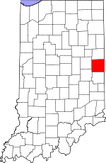
Randolph County, Indiana Basics:


Randolph County Indiana - Government Site

Population: 25,848
Area: 452 square miles
County seat: Winchester
Area code(s) in use: 765
Time zone: EST
High school graduate or higher: 85.9%
Bachelor's degree or higher: 12.1%
Median household income: $40,910
Persons in poverty: 16.3%
Home ownership rate: 74.6%
Mean travel time to work: 22.1 minutes


Adjacent counties:
Darke (OH)  Delaware  Henry  Jay  Wayne  

Find in Indiana

Map of the Randolph County area


Our detail map of Randolph County shows the Randolph County, Indiana boundary lines and other interesting items.

Places in Randolph County, Indiana

  Airports     show all on map

Pulley Airport, Randolph County Airport, Saratoga Airport

  Buildings     show all on map

Farmland Fire Department, Lynn Fire Department, Modoc Fire Department, Parker City Emergency Medical Services, Parker Volunteer Fire Department, Randolph County Emergency Medical Services, Ridgeville Fire Department, Union City Fire Department, Ward Township Volunteer Fire Department, West Union Fire Department, White River Township Fire Department, Winchester Fire Department

  Canals     show all on map

Armstrong Anderson Ditch, Bowen Ditch, Bray Ditch, Colvin Ditch, De Armond Ditch, Denton Ditch, Edwards Ditch, Elson Ditch, Farquiner Ditch, Flesher Creek, Gettinger Ditch, Girton Ditch, Harshman Ditch, Heuss Ditch, Hinshall Ditch, Hutchison Ditch, Kelly Ditch, Lamb Ditch, Little Ditch, Mitchell Ditch, Morman Ditch, O'Conner Ditch, Price Ditch, Rhoades Ditch, Shelley Ditch, Shelly Ditch, Stevens Ditch, Uphaus Ditch

  Cemeteries     show all on map

Bartonia Cemetery, Bear Creek Cemetery, Brick Memorial Park Cemetery, Buena Vista Cemetery, Caylo Cemetery, Cherry Grove Cemetery, Cherry Grove Cemetery, Conklin Cemetery, Fairview Cemetery, Fountain Park Cemetery, Gable Cemetery, Hoover Cemetery, Hoover Cemetery, Huntsville Cemetery, Lawn Dale Cemetery, Little Creek Cemetery, Moffitt Cemetery, Mosier Cemetery, Mount Gilliard Cemetery, Mount Pleasant Cemetery, Nettle Creek Cemetery, Odd Fellows Cemetery, Old Prospect Cemetery, Poplar Run Cemetery, Quaker Lynn Cemetery, Reitenour Cemetery, Riverside Cemetery, Riverside Cemetery, Saint Marys Cemetery, Salem Cemetery, Saratoga Cemetery, Scott Cemetery, Shockney Cemetery, Sparrow Creek Cemetery, Swingley Cemetery, Union City Cemetery, Veterans Cemetery, Weimer Cemetery, Wood Cemetery, Woodlawn Cemetery

  Churches     show all on map

Bear Creek Church, Buena Vista Church, Calvary Church, Cedar Church, Cherry Grove Tabernacle, Clear Creek Church, Dunkirk Church, Emmetsville Church, Gospel Church, Grace Chapel, Jericho Church, Martindale Church, Maxville Church, Mississinewa Church, Modoc Bethel Church, Mount Zion Church, Mount Zion Church, New Dayton Church, New Liberty Church, North White River Church, Olive Branch Church, Pleasant Hill Church, Pleasant Valley Church, Poplar Run Church, Randolph Church, Rehoboth Church, Saint Mary Church, Union Church, Union Church, Union Church, Wesleyan Church, White River Church

  Hospitals     show all on map

Saint Vincent Randolph Hospital

  Locales     show all on map

Airline Twin Drive-In, Bedrock Farms, Burrow Farms, Cates Farms, Deer Ridge Farm, Edwards Farms, Flesher Farms, Flyin S Ranch, Groth Farms, Harris Farms, Lester Farms, Maxwell Farms of Indiana, McCormick Farms, Pool Hog Farms, R and R Hog Farms, Ridgeville Elevator, Silver Towne Farms, Smithson Farms, Stone Road Farm, Sunny Meadows, T K Hog Farm, Winchester Speedway, Woodbury Farms

  Parks     show all on map

Goodrich Park

  Populated Places     show all on map

Arba, Bartonia, Bloomingport, Buena Vista, Carlos, Crete, Deerfield, Fairview, Farmland, Georgetown, Harrisville, Haysville Corner, Huntsville, Losantville, Lynn, Maxville, Modoc, Mull, New Lisbon, New Pittsburg, Parker City, Pinch, Randolph, Ridgeville, Rural, Saratoga, Scott Corner, Shedville, Snow Hill, South Salem, Spartanburg, Stone, Union City, Unionport, Winchester, Windsor

  Schools     show all on map

Deerfield Elementary School, Farmland Elementary School, Lee L Driver Junior High School, Monroe Central Junior-Senior High School, North Side Elementary School, O R Baker Elementary School, Oliver P Morton Elementary School, Parker Elementary School, Purdue University Agriculture Station, Randolph Southern Junior-Senior High School, Stoney Creek School, Union City Community High School, Union Elementary School, Union Junior and High School, Ward-Jackson School, West Side Middle School, White River Elementary School, Willard Elementary School, Winchester Community High School

  Streams     show all on map

Ball Run, Bartonia Run, Bear Creek, Block Run, Bloomingport Creek, Bush Creek, Cabin Creek, Campbell Creek, Card Run, Carder Creek, Carlos Drain, Cherry Run, City Drain, Clear Creek, Copy Run, Country Run, Cream Run, Crete Drain, Days Creek, Deck Run, Dinner Creek, Eagle Run, Eightmile Creek, Elkhorn Creek, Fetid Creek, Friend Run, Gable Run, Goshen Creek, Great Run, Green Branch, Grove Run, Harshman Creek, Hickory Creek, Hoover Run, Huntsville Drain, Jordon Creek, Karn Branch, Little Mississinewa River, Little Mud Creek, Little White River, Lows Branch, Lynn River, Miller Creek, Mortar Run, Mud Creek, Mud Creek, Mud Creek, Nameless River, O'Brien Creek, Owl Creek, Peach Creek, Pit Run, Polar Run, Poplar Run, Port Run, Porter Creek, Potent Run, Quaker Run, Rail Run, Rank Run, Ridge Run, Roots Run, Salt Creek, Slow Run, Snow Run, South Salem Run, Sparrow Creek, Spartanburg Creek, State Run, State Run, Stoney Creek, Sugar Creek, Thin Run, Tough Run, Vandyke Run, Villa Run, Ville Run, Virile Run

  Towers     show all on map

WZZY-FM (Winchester),

Randolph County, Indiana Population By Race (2012 estimate)

RacePopulation
WhiteRandolph County White population 25,25325,253  
MixedRandolph County Mixed population 284284
BlackRandolph County Black population 155155
American IndianRandolph County American Indian population 103103
AsianRandolph County Asian population 7877
Hawaiian & Pacific IslanderRandolph County Hawaiian & Pacific Islander population 00

Additional population tables :
State population table
Indiana population by county