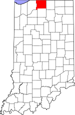
St. Joseph County, Indiana Basics:


St. Joseph County Indiana - Government Site

Population: 266,461
Area: 458 square miles
County seat: South Bend
Area code(s) in use: 574
Time zone: EST
High school graduate or higher: 87.8%
Bachelor's degree or higher: 26.5%
Median household income: $44,989
Persons in poverty: 16.4%
Home ownership rate: 70.1%
Mean travel time to work: 19.9 minutes


Adjacent counties:
Berrien (MI)  Cass (MI)  Elkhart  La Porte  Marshall  Starke  

Find in Indiana

Map of the St. Joseph County area


Our detail map of St. Joseph County shows the St. Joseph County, Indiana boundary lines and other interesting items.

Places in St. Joseph County, Indiana

  Airports     show all on map

C. V. Airport, Cam-Air Airport, Chain-O-Lakes Airport, Dreessen Field Airport, Esther Landing Pad Airport, Foos Field Airport, Hackbarth Airport, Hustons Airport, Indiana University at South Bend Airport, May's Strip Airport, McClures Airport, Nelund Field Airport, South Bend Airport, Stewarts Green Acres Airport

  Bays     show all on map

Baugo Bay

  Bridges     show all on map

Bittersweet Bridge, Bittersweet Bridge

  Buildings     show all on map

Accel Emergency Medical Services, Centre Township Fire Department, Clay Fire Territory Station 1, Clay Fire Territory Station 2, Clay Fire Territory Station 3, German Township Volunteer Fire Department Station 2, Hansel Neighborhood Center, Harris Township Fire Department Station 1, Harris Township Fire Department Station 2, Indiana Emergency Services, Lakeville Union Township Fire Department, Liberty Township Ambulance Service, Liberty Township Volunteer Fire Department, Madison Hospital and Care Center, Madison Township Volunteer Fire Department, Mishawaka Fire Department Station 1, Mishawaka Fire Department Station 2, Mishawaka Fire Department Station 3, Mishawaka Fire Department Station 4, Morris Performing Arts Center, New Carlisle Fire Department, Osceola Fire Department Station 1, Osceola Volunteer Fire Department Station 1, Osceola Volunteer Fire Department Station 2, Penn Township Fire Department Station 1, Penn Township Fire Department Station 2, Penn Township Fire Department Station 3, Penn Township Fire Department Station 4, Portage Township Volunteer Fire Department, Riverside Hospital and Care Center, Saint Joseph County Airport Authority Department of Public Safety Fire Station, South Bend Civic Theatre, South Bend Fire Department Station 1, South Bend Fire Department Station 10, South Bend Fire Department Station 11, South Bend Fire Department Station 2, South Bend Fire Department Station 2 Emergency Transport Service, South Bend Fire Department Station 3, South Bend Fire Department Station 4, South Bend Fire Department Station 5, South Bend Fire Department Station 6, South Bend Fire Department Station 7, South Bend Fire Department Station 8, South Bend Fire Department Station 9, Stoller Nursery, Tower Building, Union North Ambulance Service, University of Notre Dame Fire Department, Varga's Nursery, Walkerton - Polk - Lincoln Emergency Medical Services, Walkerton Fire Department, Warren Township Fire Department Station 1, Warren Township Fire Department Station 2

  Canals     show all on map

Aldrich Ditch, Anthony Ditch, Authen Ditch, Barkey Ditch, Billman Ditch, Breckenridge Ditch, Chain-O-Lakes Ditch, Dixon West Place Ditch, East Branch Bunch Ditch, Eberly Ditch, Eller Ditch, Eller Ditch, Elmer Kane Ditch, Elmer Kane Lateral, Fulmer Ditch, Gast Ditch, Geyer Ditch, Grimes Ditch, Grimes Ditch, Gross Ditch, Heston Ditch, Hoffman Ditch, Kline-Rouch Ditch, Ladig Ditch, Lateral Number Fifteen Ditch, Lateral Number Five, Lateral Number Five Ditch, Leman Birk Newcomer Ditch, Louck Ditch, Marker Ditch, Miller Ditch, Oliver Heckaman Ditch, Pittman Ditch, Pittman Gordon Ditch, Rogers Ditch, Schang Ditch, Shidler - Hoffman Ditch, West Branch Bunch Ditch

  Capes     show all on map

Eagle Point

  Cemeteries     show all on map

Bowman Cemetery, Cedar Grove Cemetery, Chapel Hill Memorial Gardens, Eutzler Cemetery, Fair Cemetery, Fairview Cemetery, Ferrisville Cemetery, Harris Prairie Cemetery, Highland Cemetery, Hungarian Sacred Heart Cemetery, Lakeville Cemetery, Mount Calvary Cemetery, Old Cemetery, Olive Chapel Cemetery, Pleasant Valley Cemetery, Porter Cemetery, Resthaven Cemetery, Riverview Cemetery, Saint Josephs Cemetery, Saint Josephs Cemetery, Saint Josephs Cemetery, Southlawn Cemetery, Southlawn Cemetery, Stuckey Cemetery, Sumption Prairie Cemetery, Van Buskirk Cemetery, Westlawn Cemetery

  Census     show all on map

Georgetown Census Designated Place, Granger Census Designated Place, Gulivoire Park Census Designated Place, Notre Dame Census Designated Place

  Churches     show all on map

Bethel Temple, Coalbush Church, County Line Church, Emmaus Lutheran Church, First African Methodist Episcopal Zion Church, First Baptist Church, First Brethren Church, First Christian Church, First Church of Christ Scientist, First Presbyterian Church, First United Methodist Church, Gloria Dei Lutheran Church, Grace Church, Granger Missionary Church, Harris Prairie Church, Hilltop Lutheran Church, Immanuel Church, Lake Chapel, Little Flower Church, Madison Church, Madison Union Church, Maple Grove Church, Monson Chapel, Morning Star Church, Mount Pleasant Church, New Apostolic Church, Northway Church, Oak Grove Church, Olive Branch Church, Olive Chapel, Our Redeemer Lutheran Church, Pine Creek Church, Pleasant View Church, Portage Chapel, Sacred Heart Church, Saint Francie Convent, Saint Johns Church, Saint Johns Church, Saint Marks Church, Saint Pauls Church, Saint Stanislaus Church, Salem Church, Southside Church, Sumption Prairie Church, Suthlawn Church, Tabor Church, Tamarack Church, Union Church, Valley Bible Church, Willow Creek Church, Zion Church

  Crossings     show all on map

Interchange 8

  Dams     show all on map

Potato Creek Reservoir Dam

  Hospitals     show all on map

Healthwin Hospital, Madison Center Hospital for Children, Memorial Hospital of South Bend, Saint Joseph Regional Medical Center Mishawaka Campus, Saint Joseph's Regional Medical Center, Triumph Our Lady of Peace Hospital

  Lakes     show all on map

Catfish Lake, Chain O' Lakes, Chamberlain Lake, Deer Lake, Dine Lake, Dipper Lake, Dollar Lake, Elizabeth Lake, Fites Lake, Hardys Lake, Kale Lake, Lancaster Lake, Lost Lake, Moon Lake, Mud Lake, Mud Lake, North Chain Lake, Pinhook Lake, Pleasant Lake, Riddles Lake, Rupel Lake, Saint Josephs Lake, Saint Marys Lake, Sommers Lake, South Chain Lake, South Clear Lake, South Clear Lake, Spicer Lake, Twin Lakes, Wharton Lake

  Locales     show all on map

Cartier Field Stadium, Clearview Farms, Freehauf Farm, Good Brothers Farm, J and J Dairy Farm, Klotz Tree Farm, Kuhn Farm, McKinley Town and County Shopping Center, Morris Park Country Club, North Pumping Station, Notre Dame Stadium, Phelps Farms, Schlarb Farm, Schmidt Farms, Scottsdale Mall, Sha - Ron Farm, South Bend City Waterworks, South Bend Country Club, South Bend Motor Speedway, South Bend Plaza, South Bend Wastewater Treatment Plant, University Center, University Park Mall

  Mines     show all on map

South Bend Sand and Gravel Pit, South Bend Sandpit

  Parks     show all on map

Battell Park, Bell Band Park, Belleville Gardens Playground, Bendix Park, Bendix Woods Park, Camp Millhouse, Camp Wakinda, Coquillard Park, Edison Park, Gibhard Playground, Harmony Park, Harrison Park, Hills Hans Park, Howard Park, Kaiser Park, Kamm Island Park, Keller Park, Kelly Playground, La Salle Park, Laing Park, Leeper Park, Lincoln Park, Muessel Grove Park, Navarre Park, Normain Heights Park, Obrien Park, Petro Park, Pinhook Park, Potato Creek State Park, Potawatom Park, Ravina Park, Rose Park, Rum Village Park, Saint Joseph Valley Memorial Park, Studebaker Park, Temple Park, Veterans Memorial Park, Voorde Park, Walker Field, Westhaven Park, Wilson Park

  Populated Places     show all on map

Ardmore, Chain-O-Lakes, Colburn, Crest Manor Addition, Crumstown, Dreamwold Heights, Georgetown, Gilmer Park, Granger, Gulivoire Park, Hamilton, Hi-View Addition, Hubbard, Indian Village, Lakeville, Lydick, Maple Lane, Miami Trails Addition, Midway Corners, Mishawaka, New Carlisle, North Liberty, Nutwood, Olive, Orchard Heights Addition, Osceola, Pine Station, Pleasant Valley, Roseland, South Bend, State Line, Tamarack Grange, Terre Coupee, Walkerton, Westfield, Woodland, Wyatt, Zeigler

  Post Offices     show all on map

West York Post Office (historical)

  Reservoirs     show all on map

Worster Lake

  Schools     show all on map

Alexis Coquillard Elementary School, Battell Elementary School, Beiger Elementary and Junior High School, Benjamin Harrison Elementary School, Bethel College, Bingham Elementary School, Booth Tarkington Elementary School, Brown School, Central High School, Clark School, Clay High School, Clay Middle School, Colfax School, Corpus Christi School, Darden Elementary School, Edward Eggleston Elementary School, Elm Road Elementary School, Elsie Rogers Elementary School, Emmons Elementary and Junior High School, Forest G Hay Elementary School, Franklin School, Greene Elementary School, Harold C Urey Middle School, Henry Studebaker Elementary School, Holy Cross Junior College, Holy Cross School, Holy Family School, Indiana University South Bend, Indiana University South Bend Campus, Indiana Vocational Technical School, James Madison Elementary School, James Monroe Elementary School, John Adams High School, John F Kennedy Elementary School, John F Nuner Elementary School, John Glenn High School, John J O'Brien Special Education School, John Marshall Elementary School, Kaley School, Lafayette Elementary School, Lakeville Elementary School, Lasalle Elementary School, Lasalle High School, Laville Junior-Senior High School, Lincoln Elementary School, Linden School, Logan School, Main School, Marian High School, Marquette Elementary School, Mary Frank School, Mary Phillips Elementary School, McKinley Elementary School, Mishawaka High School, Moran Elementary School, Muessel Elementary School, North Liberty School, North Side Elementary School, Olive Township Elementary School, Oliver School, Osceola Elementary School, Our Lady of Hungary School, Penn High School, Perley Elementary School, Pierre Navarre Middle School, Queen of Peace School, Roner School, Sacred Heart School, Saint Adalbert School, Saint Anthony De Padua School, Saint Bavo School, Saint Casimirs School, Saint John the Baptist School, Saint Joseph High School, Saint Joseph School, Saint Joseph School, Saint Mary of the Assumption School, Saint Marys Academy, Saint Marys College, Saint Monica School, Saint Patrick School, Saint Pauls School, Saint Stanislawa School, Saint Stephens School, Schmucker Middle School, South Bend College, South Side School, Swanson Highlands Elementary School, Thomas A Edison Middle School, Thomas Jefferson Elementary School, Twin Branch Elementary School, University of Notre Dame, Walkerton Elementary School, Washington High School, Woodrow Wilson School

  Streams     show all on map

Baugo Creek, Bowman Creek, Jordans Creek, Judy Creek, Kartoffel Creek, Minnow Branch, Pine Creek, Potato Creek, Spud Run, Willow Creek, Yellow Bank Creek

  Summits     show all on map

Reeves Hill, Vargo Hill

  Towers     show all on map

WAMJ-AM (South Bend), WNDU-AM (South Bend), WNDU-TV (South Bend), WSBT-AM (South Bend), WSBT-TV (South Bend), WSJV-TV (Elkhart), WVPE-FM (Elkhart),

St. Joseph County, Indiana Population By Race (2012 estimate)

RacePopulation
WhiteSt. Joseph County White population 217,699217,698  
BlackSt. Joseph County Black population 34,64034,639
MixedSt. Joseph County Mixed population 6,9286,927
AsianSt. Joseph County Asian population 5,5965,595
American IndianSt. Joseph County American Indian population 1,3321,332
Hawaiian & Pacific IslanderSt. Joseph County Hawaiian & Pacific Islander population 266266

Additional population tables :
State population table
Indiana population by county