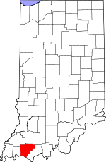
Warrick County, Indiana Basics:


Warrick County Indiana - Government Site

Population: 60,445
Area: 385 square miles
County seat: Boonville
Area code(s) in use: 812
Time zone: CST
High school graduate or higher: 92.0%
Bachelor's degree or higher: 26.8%
Median household income: $61,948
Persons in poverty: 9.4%
Home ownership rate: 82.5%
Mean travel time to work: 22.4 minutes


Adjacent counties:
Daviess (KY)  Dubois  Gibson  Henderson (KY)  Pike  Spencer  Vanderburgh  

Find in Indiana

Map of the Warrick County area


Our detail map of Warrick County shows the Warrick County, Indiana boundary lines and other interesting items.

Places in Warrick County, Indiana

  Airports     show all on map

Boonville Airport, Cornell Airport, Raceway Airport

  Buildings     show all on map

Aluminum Company of America Fire Department and Emergency Medical Services, Boonville Fire Department, Chandler Volunteer Fire Department, Elberfeld Volunteer Fire Department, Folsomville Volunteer Fire Department, Izaak Walton League Building, Lynnville Volunteer Fire Department, Newburgh Volunteer Fire Department, Ohio Township Fire and Rescue Station 1, Ohio Township Fire and Rescue Station 2, Pigeon Township Volunteer Fire Department, Skelton Township Fire Department, The Womans Hospital, Yankeetown Volunteer Fire Department

  Canals     show all on map

Angel Ditch, Barnes Ditch, Boesche Ditch, Brinkmeyer Ditch, Carter Traylor Ditch, Daniel Huegel Ditch, Davis Enlow Ditch, Dennis Klippel Ditch, Dennis Wagner Ditch, Edwards Ditch, Ellison West Ditch, Fehd Ditch, Gardner Webb Ditch, Hansen Ditch (historical), Hines Ditch, Hoskinson Drain, Howard Ditch, Kaiser Ditch, Kelly Ditch, Koehler Ditch, Lockwood Ditch, McCool Ditch, Mitchem Ditch, Pokeberry Ditch, Polkberry Ditch, Powers Ditch, Pursley Ditch, South Willow Pond Ditch, Stollberg Ditch, Stubbs Fruedenberg Ditch, Summer Pecka Ditch, Taylor Ditch, Wallace Fork Ditch, Weinsheimer Ditch, Whittaker Ditch, Williams Ditch, Wires Ditch, Woods Ditch

  Cemeteries     show all on map

Asbury Cemetery, Ashby Cemetery, Avery Cemetery, Baker Cemetery, Barrenfork Cemetery, Bates Hill Cemetery, Broshears Cemetery, Brown Chapel Cemetery, Bruce Cemetery, Casey Cemetery, Chinn Cemetery, Clark Cemetery, Clutter Stone Cemetery, Crossroad Cemetery, Ebenezer Cemetery, Ellis Cemetery, Garrison Cemetery, Graff Cemetery, Greenwood Cemetery, Hedge Cemetery, Hedge Cemetery, Kelley Cemetery, Leslie Cemetery, Lynnville Cemetery, Maple Grove Cemetery, Massey Cemetery, Mill Cemetery, Morrison Cemetery, Mount Olive Cemetery, Northview Cemetery, Perigo Cemetery, Plainview Memorial Cemetery, Polk Cemetery, Polk Cemetery, Reed Cemetery, Rose Hill Cemetery, Roth Cemetery, Saint Clair Cemetery, Shiloh Cemetery, Small Cemetery, Susett Cemetery, Thornburg Cemetery, Twin Cemetery, Warren Cemetery, Wesley Cemetery, Wetherill Cemetery, Williams Cemetery, Zion Cemetery

  Churches     show all on map

Baker Chapel, Barnetts Chapel, Barrenfork Church, Bethabara Church, Bethany Church, Bethel Tabernacle, Ebenezer Church, Ebenezer Church, Epworth Church, Faith Free Will Baptist Church, Fletcher Chapel, Freedom Church, Friendship Church, Garrison Chapel, Gateway Church, Johnson Chapel, Liberty Chapel, Little Zion Church, Mount Gilead Church, North Friendship Church, Oak Grove Church, Old Friendship Church, Otter Creek Church, Pleasant Chapel, Pleasant Hill Church, Saint Johns Church, Saint Matthews Church, Saint Ruperts Church, Sharon Church, Shiloh Church, Townsend Church, Union Church, Zion Church, Zoar Church

  Dams     show all on map

Dubois Community Club Lake Dam, Hendrickson Lake Dam, Washing-Recirculating Reservoir Dam, Yellow Bank Lake Dam

  Hospitals     show all on map

Deaconess Gateway Hospital, Saint Marys Warrick Hospital, Women's Hospital

  Lakes     show all on map

City Lake Number One, City Lake Number Two, Warrens Lake

  Locales     show all on map

Boonville Country Club, Indian Fort, Oak Hill Conservation Club, Rolling Hills Golf Course

  Mines     show all on map

Elberfeld Mine, Houston Mine, Lynnville Mine, Shaw Mine, Tecumseh Mine

  Parks     show all on map

Bethel Camp, Breckenridge Park, Bullivant Park, Scales Lake County Park

  Populated Places     show all on map

Ash Iron Springs, Baugh City, Boonville, Bullocktown, Camp Brosend, Castle Garden, Center, Chandler, Dayville, De Gonia Springs, Dickeyville, Eames, Eby, Elberfeld, Fisherville, Folsomville, Graham Valley, Greenbrier, Heilman, Hemenway, Hillcrest Terrace, Jarretts, Jockey, Loafers Station, Lynnville, Millersburg, New Hope, Newburgh, Paradise, Pelzer, Red Bush, Rolling Acres, Rosebud, Rustic Hills, Saint John, Scalesville, Selvin, Stanley, Stevenson, Tennyson, Turpin Hill, Vanada, Wheatonville, Yankeetown

  Post Offices     show all on map

Crowville Post Office (historical), Eby Post Office (historical)

  Reservoirs     show all on map

Chase Lake, Collins Lake, Hendrickson Lake, Perdido Lake (historical), Pfafflin Lake, Washing Recirculating Reservoir, Yellow Bank Lake

  Schools     show all on map

Boonville High School, Boonville Junior High School, Castle High School, Chandler Elementary School, Clarke School, John H Castle Elementary School, Lynnville Elementary School, Newburgh Elementary School, Oakdale Elementary School, Saint Clements School, Saint John the Baptist School, Tecumseh High School, Williams School, Yankeetown Elementary School

  Streams     show all on map

Barren Fork, Big Creek, Bluegrass Creek, Brushy Fork, Caney Creek, Clear Branch, Clear Creek, Coles Creek, Cypress Creek, Euler Branch, Little Creek, Little Red Creek, Muddy Creek, North Fork Little Pigeon Creek, Otter Creek, Plum Branch, Pokeberry Creek, Robinson Creek, Rough Creek, Smith Fork, South Fork Patoka River, Squaw Creek, Sugar Creek, Sugar Creek Drain

  Summits     show all on map

Big Ditney Hill, Dyson Knob, Little Ditney Hill, Lost Hill, Ringham Hill

  Towers     show all on map

WBNL-AM (Boonville), WBNL-FM (Boonville), WNIN-TV (Evansville), WTVW-TV (Evansville),

Warrick County, Indiana Population By Race (2012 estimate)

RacePopulation
WhiteWarrick County White population 57,60457,604  
AsianWarrick County Asian population 1,0281,027
MixedWarrick County Mixed population 846846
American IndianWarrick County American Indian population 121120
Hawaiian & Pacific IslanderWarrick County Hawaiian & Pacific Islander population 00

Additional population tables :
State population table
Indiana population by county