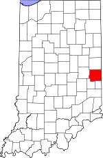
Wayne County, Indiana Basics:


Wayne County Indiana - Government Site

Population: 68,279
Area: 402 square miles
County seat: Richmond
Area code(s) in use: 765
Time zone: EST
High school graduate or higher: 82.9%
Bachelor's degree or higher: 17.1%
Median household income: $39,131
Persons in poverty: 19.9%
Home ownership rate: 67.5%
Mean travel time to work: 20.1 minutes


Adjacent counties:
Darke (OH)  Fayette  Henry  Preble (OH)  Randolph  Union  

Find in Indiana

Map of the Wayne County area


Our detail map of Wayne County shows the Wayne County, Indiana boundary lines and other interesting items.

Places in Wayne County, Indiana

  Airports     show all on map

Hagerstown Airport, Pentecost Airport, Richmond Municipal Airport, Squires Airport, White Airport

  Buildings     show all on map

Abington Township Fire Department, Abington Township Volunteer Fire Department, Boston Fire Department, Cambridge City Volunteer Fire Department, Centerville Fire and Rescue, Clay Township Volunteer Fire Department, Culberson Emergency Medical Services, Dublin Volunteer Fire and Rescue, Fountain City - New Garden Township Fire Department, Hagerstown - Jefferson Township Volunteer Fire Department, Levi Coffin House, Milton Washington Township Fire Department, Perry Township Volunteer Fire Department, Richmond Fire Department, Richmond Fire Department Station 2, Richmond Fire Department Station 3, Richmond Fire Department Station 4, Richmond Fire Department Station 5, Richmond Fire Department Station 6, Rural / Metro Ambulance - Richmond, Smith Esteb Memorial Home, Webster Volunteer Fire Department, Williamsburg Volunteer Fire Department

  Canals     show all on map

Addleman Ditch, Cain Ditch, Dalton Drain, Gephart Ditch, Hinshaw Ditch, Knollenberg Ditch, Ross Ditch, Whitewater Canal, Whitwater Canal

  Cemeteries     show all on map

Awl Branch Cemetery, Beard Cemetery, Bethel Cemetery, Brick Church Cemetery, Capitol Hill Cemetery, Crown Hill Cemetery, Crown Hill Cemetery, Dover Cemetery, Earlham Cemetery, East Cemetery, Economy Cemetery, Fairfield Cemetery, Franklin Cemetery, Friends Cemetery, Glen Haven Memorial Gardens, Greens Fork Cemetery, Hoover Bulla Cemetery, Independent Order of Odd Fellows Cemetery, Jordon Cemetery, King Cemetery, Locust Grove Cemetery, Lutherania Cemetery, Mount Vernon Cemetery, Old Center Cemetery, Old Concord Cemetery, Ridge Cemetery, Riverside Cemetery, Saint Andrews Cemetery, South Lawn Cemetery, South Side Cemetery, State Line Cemetery, Ulrich Cemetery, United Brethren Cemetery, Wernle Cemetery, West Grove Cemetery, West Lawn Cemetery, West Side Cemetery, Williamsburg Cemetery, Willow Grove Cemetery

  Churches     show all on map

Bryant Church, Calvary Church, Christ Church, Doddridge Chapel, Goshen Chapel, Hopewell Church, Locust Grove Church, Morgan Creek Church, Nettle Creek Church, Nettle Creek Church, New Garden Church, Saint Johns Church, Saint Pauls Church, Saint Pauls Church, Salem Church, Sugar Grove Church, Trinity Church, Valley Grove Church, West River Church, White Branch Church, Zion Church

  Dams     show all on map

Dawn Lake Dam, Glen White Dam, Middle Fork Reservoir Dam

  Falls     show all on map

Elkhorn Falls

  Hospitals     show all on map

Reid Hospital and Health Care Services, Richmond State Hospital, Richmond State Hospital Farm

  Lakes     show all on map

Elkhorn Lakes, Hi-Way Springs, Osborne Lakes, Scout Lake

  Locales     show all on map

Forest Hills Golf Course, Howell Farms, Radford Hog Farms, Young Stadium

  Mines     show all on map

Cambridge City Pit, House Gravel Pit, Middleboro Pit, Middleboro Stone Quarry

  Parks     show all on map

Camp Wapi Kamigi, Clear Creek Park, Criotz Park, Glenn Miller Park, Starr Park, Wilson Park

  Populated Places     show all on map

Abington, Beesons, Bethel, Boston, Cambridge City, Centerville, Chester, College Corner, Dalton, Dublin, East Germantown, East Haven, Economy, Fountain City, Franklin, Greens Fork, Greenwood, Hagerstown, Hiser, Hoover Mill, Jacksonburg, Locust Grove, Middleboro, Milton, Mount Auburn, Pennville, Pinhook, Richmond, South Richmond, Spring Grove, Spring Grove Heights, Wayne, Webster, West Grove, Whitewater, Williamsburg

  Post Offices     show all on map

New Centre Post Office (historical), Olive Hill Post Office (historical)

  Reservoirs     show all on map

Glen White Lake, Middle Fork Reservoir, We-Hi Lake

  Schools     show all on map

Central Elementary School, Charles Elementary School, Dennis David Worth Junior High School, Dublin Elementary School, Earlham College, Fairview Elementary School, Finley School, Hibberd Junior High School, Highland Heights Elementary School, Julia E Test Junior High School, Lincoln High School, Milton Elementary School, Nicholson School, Parkway Junior High School, Pershing Elementary School, Pleasant View Junior High School, Richmond Senior High School, Saint Andrews School, Sevastopol School, Starr Elementary School, Vaile Elementary School, Warner School, Williamsburg Elementary School

  Streams     show all on map

Auburn Brook, Awl Branch, Bat Branch, Bear Creek, Beard Run, Berg Brook, Bethel Creek, Black Brook, Black Run, Black Water Branch, Boro Brook, Boston Creek, Brethren Run, Brick Creek, Bridge Brook, Bryant Creek, Butlers Creek, Center Run, Centeral Run, Centrum Run, Chester Creek, City Run, Civil Run, Clay Run, Clear Creek, Cold Run, College Corner Branch, Collor Creek, Common Run, Cool Brook, Coon Creek, Corey Run, Cream Run, Crietz Creek, Crown Creek, Dover Run, Dry Branch, East Fork Whitewater River, Economy Run, Elkhorn Creek, Evans Creek, Far Run, Fellow Brook, Flight Run, Fork Creek, Fountain Creek, Franklin Creek, Franklin Run, Free Run, Fruit Branch, Garden Run, Gray Brook, Greens Fork, Grove Creek, Hartley Run, High Brook, Hiser Drain, Hopewell Run, Horn Creek, Jordon Creek, Knoll Run, Land Drain, Lick Branch, Lick Creek, Line Brook, Little Creek, Locust Creek, Long Creek, Martindale Creek, Middle Brook, Middle Fork East Fork Whitewater River, Middle Run, Milton Drain, Mixed Creek, Mono Run, Mop Run, Morgan Creek, Morgan Creek, Mud Creek, Mud Run, Nail Creek, Nettle Creek, Nolands Fork, Odd Run, Oser Creek, Our Run, Pale Run, Pinhook Drain, Point Run, Pole Creek, Price Creek, Pronghorn Run, Propeller Run, Quack Creek, Quill Creek, Reel Run, Rich Creek, Shaker Run, Short Creek, Show Run, Silver Brook, Silver Creek, Silver Station Brook, Single Creek, Single Run, Sleet Brook, Slow Run, Small Run, Smith Creek, Snow Run Brook, Spike Brook, Spring Run, Springs Run, Square Run, Swab Creek, Symonds Creek, Tea Creek, Tie Run, Town Creek, Tree Brook, Ulrich Creek, Value Run, Vernon Brook, Warm Run, Wash Branch, Web Branch, Web Creek, Webster Creek, Well Brook, West Brook, West Fork East Fork Whitewater River, West Lawn Run, West River, White Branch, White Creek, William Creek, Williamsburg Creek, Willow Run, Wilson Run, Wing Branch, Winter Run, Woodclinch Brook, Woods Branch, Youngs Brook

  Summits     show all on map

Hoosier Hill

  Towers     show all on map

WECI-FM (Richmond), WHON-AM (Centerville), WKBV-AM (Richmond), WQLK-FM (Richmond), WRIA-FM (Richmond),

Wayne County, Indiana Population By Race (2012 estimate)

RacePopulation
WhiteWayne County White population 62,20262,202  
BlackWayne County Black population 3,4823,482
MixedWayne County Mixed population 1,7751,775
AsianWayne County Asian population 546546
American IndianWayne County American Indian population 205204
Hawaiian & Pacific IslanderWayne County Hawaiian & Pacific Islander population 6868

Additional population tables :
State population table
Indiana population by county