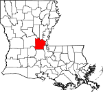
Avoyelles Parish, Louisiana Basics:
Avoyelles Parish Louisiana - Government Site
Population: 41,569
Area: 832 square miles
Parish seat: Marksville
Area code(s) in use: 318
Time zone: CST
High school graduate or higher: 69.7%
Bachelor's degree or higher: 9.6%
Median household income: $34,512
Persons in poverty: 23.1%
Home ownership rate: 69.5%
Mean travel time to work: 30.8 minutes
Adjacent counties:
Catahoula Concordia Evangeline La Salle Pointe Coupee Rapides St. Landry West Feliciana
Places in Avoyelles Parish, Louisiana
Belle D'Eau Airstrip,
Bonshaven Landing Strip,
Brumfield Landing Strip,
Bunkie Flying Service Airport,
Bunkie Municipal Airport,
Haas Landing Strip,
Humana Hospital Heliport,
Kent's Flying Service Airport,
Marksville Municipal Airport,
Max Airport,
Mixon Airport,
Mixon Airport,
Rays Landing Strip,
WD Flyers Airport Île des Côtes Achiquot Bay,
Baie Sec,
Cockleburr Bay Avoyelles Correctional Center,
Avoyelles Parish Courthouse,
Avoyelles Parish Markesville Detention Center,
Avoyelles Parish Women's Correctional Center,
Bordelonville Volunteer Fire Department,
Brouillette Volunteer Fire Department Substation,
Bunkie Fire Department,
Colonial Nursing Home,
Cottonport Volunteer Fire and Rescue,
Dupont Volunteer Fire Department Main Station,
DuPont Volunteer Fire Department Sub Station 1,
DuPont Volunteer Fire Department Sub Station 2,
Effie Volunteer Fire Department,
Evergreen Volunteer Fire Department,
Fifth Ward Volunteer Fire Department,
Fifth Ward Volunteer Fire Department,
Goudeau Volunteer Fire Department,
Hessmer Volunteer Fire Department,
Mansura Volunteer Fire Department,
Marksville City Hall,
Marksville Public Library,
Marksville Volunteer Fire Department,
Moreauville Volunteer Fire Department,
Plaucheville Volunteer Fire Department,
Simmesport Volunteer Fire Department Bayou Boeuf - Cocodrie Diversion Channel,
Bayou Boeuf-Cocodrie Diversion Channel,
Bayou Roseau Drainage Canal,
Choupique Canal,
Coco Canal,
State Canal,
Turner Canal,
Turners Bayou Canal Pointe Basse,
Pointe Saline,
Pointe Tournant Baibry Cemetery,
Bordelon Cemetery,
Cole Cemetery,
Cushman Cemetery,
Fogleman Cemetery,
Fort Derussy Cemetery,
French Cemetery,
Goudeau Cemetery,
Guillory Cemetery,
Hatfield Cemetery,
Hays Cemetery,
Hopewell Cemetery,
Jersalem Cemetery,
Kalone Cemetery,
Lauther Cemetery,
Morrow Cemetery,
Mount Calvary Cemetery,
Mount Olive Cemetery,
Mount Zion Cemetery,
Oak Grove Cemetery,
Old Island Cemetery,
Old Saint Paul Cemetery,
Pilgrim Rest Baptist Church Cemetery,
Plaucheville Cemetery,
Pythian Cemetery,
Robinson Cemetery,
Saint Anthony Cemetery,
Saint Catherine Cemetery,
Saint John Cemetery,
Saint Joseph Cemetery,
Saint Joseph Cemetery,
Saint Marys Cemetery,
Slocum Cemetery,
Snowden Cemetery,
Tunica-Biloxi Cemetery,
Tyler Cemetery,
Wadill Cemetery Bordelonville Census Designated Place,
Borodino Census Designated Place,
Center Point Census Designated Place,
Fifth Ward Census Designated Place,
Voorhies Census Designated Place Bayou du Lac,
Saline Cutoff Abram Temple Church of God,
Amazon Baptist Church,
Antioch Church,
Antioch Church,
Apostolic Lighthouse of Bunkie,
Bay Hill Church,
Bayou des Glaises Church,
Bayou Jacque Church,
Big Bend Church,
Bodoc Church (historical),
Center Point Church,
Christian Baptist Church,
Christian Family Worship Center,
David Haas Memorial United Methodist Church,
Dry Bayou Church,
Fifth Ward Church,
First Baptist Church,
First Evening Star Baptist Church,
First Union Church,
Golden Chain Church,
Hays Chapel,
Hillside Church,
Holy Ghost Church,
Hopewell Church,
Immaculate Conception Catholic Church,
Jerusalem Church,
Jerusalem Church,
Kingdom Hall of Jehovahs Witnesses,
La Paries Church,
Little Rock Church,
Little Zion Church,
Luneau Chapel (historical),
Magnolia Church,
Mater Doloresa Catholic Church,
Morning Star Church,
Mount Calvary Church,
Mount Olive Church,
Mount Zion Church,
New Light Church,
Oak Grove Church,
Old Morning Star Church,
Old Zion Church,
Our Lady of Lourdes Church,
Our Lady of Sorrow Church,
Pilgrim Church,
Pilgrim Rest Baptist Church,
Pleasant Greens Church,
Progressive Church,
Richey Church,
Riverside Church,
Sacred Heart Church,
Saint Catherine Church,
Saint Catherine Church,
Saint Daniel Church,
Saint Genevieve Church,
Saint James Chapel,
Saint James Church,
Saint James Church,
Saint Johns Church,
Saint Joseph Church,
Saint Joseph Church,
Saint Leo Church,
Saint Mark Church,
Saint Martin of Tours Church,
Saint Marys Baptist Church,
Saint Marys Catholic Church,
Saint Michaels Church,
Saint Paul Church,
Saint Pauls Church,
Saint Pauls Church,
Saint Peter Church,
Saint Winfred Church,
Salem Baptist Church,
Second Union Church,
Shiloh Church,
Star Light Church,
Sunrise Church,
Trinity United Methodist Church,
True Vine Church,
Vick Baptist Church,
Zion Traveler Church Grimes Bluff David Ferry (historical) Louisiana Noname 51 Dam,
Louisiana Noname 54 Dam,
Lyle Lake Dam Long Prairie,
Prairie des Avoyelles,
Vasher Prairie,
Wolf Prairie Bayou Creux,
Bayou des Cyprieres,
Bayou Du Lac,
Jumping Bayou,
Middle Bayou,
Old Saline Bayou,
Petite Baie,
Petite Bayou du Lac,
Premier Bayou,
Raccoon Bayou,
Sixmile Bayou Avoyelles Hospital,
Avoyelles Mental Health Clinic,
Bunkie General Hospital Coles Island,
Horse Island,
Ile Natchitoches Baie Ronde,
Bayou Bourbeux,
Bayou Creux,
Bayou des Allemands,
Bayou du Lac,
Bayou La Cabane,
Bayou Voinche,
Belson Lake,
Big Buttonwood Lake,
Big Lake,
Blue Hole Lake,
Boggy Lake,
Bordelon Lake,
Cannon Lake,
Central Slough,
Champignol Lake,
Coco Lake,
Coulee Noire,
Cross Lake,
Cypress Lake,
Duck Lake,
Fish Bayou Lake,
Gin Lake,
Grand Lac,
Grand Lake,
Grande Coulée,
Grassy Lake,
Grime Lake (historical),
Heifer Lake (historical),
Horseshoe Lake,
Horseshoe Lake (historical),
Jeff Lake,
Jews-harp Lake,
Jimmy Lake,
Lac à Calahan,
Lac à Cypres,
Lac à Deux Bouts,
Lac à Guillaume,
Lac a Madame Lee,
Lac a Paul,
Lac Ambroise,
Lac Amelia,
Lac aux Cygnes,
Lac aux Perles,
Lac aux Roseaux,
Lac Bec Croche,
Lac Bois Sec,
Lac Bon Garçon,
Lac Bryon de Chats,
Lac Calebasse,
Lac Choupique,
Lac Clair,
Lac de Johnson,
Lac Didier,
Lac en Travers,
Lac François,
Lac Gabriel,
Lac Grand Bayou,
Lac Long,
Lac Mama,
Lac Moreau,
Lac Ophelia,
Lac Patassa,
Lac Poisson Arme,
Lac Sainte Agnes,
Lac Saulière,
Lac Tête de Boeuf,
Lac Valerie,
Lac Volee,
Lake Little Solier,
Lake Wilson,
Les Petits Lacs à Blakewood,
Long Lake,
Lyle Lake,
Martin Bay,
Mauvais Lac,
Morel Lake,
Mouillere a Dehors,
Muscle Lake,
Nichols Lake,
Otter Lake,
Petit Lac,
Petit Lac du Grand Bryon,
Petit Lac Saulière,
Petite Baie,
Premier Lac,
Racoon Lake (historical),
Reynolds Lake,
Shark Bay,
Smith Bay,
Sutton Lake,
Tanner Lake,
Tilden Lake,
Westcut Lake West Protection Levee Bardin Landing (historical),
Bettevy Landing (historical),
Bringol Landing,
Cassandria Landing,
Deer Range Landing,
Deer Range Plantation,
Ewell Spur (historical),
Experiment Plantation (historical),
Fort De Russy,
Gardiner Landing (historical),
George Guillott Landing,
Grimes Bluff Landing,
J B Aymons Landing (historical),
Laborde Landing (historical),
Lower Deer Range Landing,
Marcotte Landing,
Martinez Landing,
Midway Landing,
Moncla Landing,
Myrtle Grove Landing,
Norman Landing,
Normand Landing (historical),
Rays Ferry (historical),
Saucier Landing,
Spring Bayou Golf Course,
Tanner Spur (historical),
Upper Ashland Landing,
Wares Landing (historical),
Wayside Bayou Milligan Oil Field,
Bayou Rouge Oil Field,
Big Cane Gas Field,
Bunkie Oil Field,
Eola Oil and Gas Field,
Five Mile Bayou Oil Field,
Haas Oil and Gas Field,
Lake Ophelia Oil Field,
Little River Oil Field,
Marksville Oil Field,
Marksville Townsite Oil Field,
Middle Bayou Oil Field,
Milligan Bayou Oil Field,
Montcrief Gas Field,
Natchitoches Bayou Oil Field,
Natchitoches Island Oil Field,
North Bayou Jack Oil and Gas Field,
North Bayou Jack Oil Field,
Red River Bay Oil Field,
Saint Leo Church Oil Field,
South Vick Oil Field,
Vick Oil Field Grassy Lake State Wildlife Management Area,
Marksville State Historic Site,
Pomme De Terre State Wildlife Management Area,
Spring Bayou State Wildlife Management Area Belle d'Eau,
Belleville,
Big Bend,
Bodoc,
Bordelonville,
Borodino,
Brouillette,
Broussard,
Bunkie,
Carboco,
Cason,
Cassandra,
Center Point,
Cocoville,
Cottonport,
Deats (historical),
Degeneres,
Dora (historical),
Dunlap,
Dupont,
Effie,
Egg Bend,
Enterprise,
Eola,
Evergreen,
Fifth Ward,
Friths (historical),
Gold Dust,
Goudeau,
Gum Ridge (historical),
Haas,
Hamburg,
Hessmer,
Hickory,
Holmesville,
Karo,
Kelley (historical),
Leinster,
Long Bridge,
Mansura,
Marksville,
McDonald (historical),
Milburn,
Moncla,
Montcla,
Moreauville,
Naples (historical),
Nibot (historical),
Nicks (historical),
Norma,
North Point,
Nugent,
Odenburg,
Oklahoma,
Plaucheville,
Red Fish,
Reynolds,
Rosewood,
Shirley (historical),
Simmesport,
Spring Bayou Landing,
Star (historical),
Stewart (historical),
Vick,
Voorhies,
Yellow Bayou Belledeau Post Office (historical), Belleville Post Office (historical), Bettery Post Office (historical), Big Bend Post Office (historical),
Bodoc Post Office (historical),
Bordelonville Post Office, Borodino Post Office (historical),
Bunkie Post Office, Cassandria Post Office (historical),
Center Point Post Office, Corner Post Office (historical), Cottonport Post Office, Couvillon Post Office (historical),
Effie Post Office, Egg Bend Post Office (historical), Eola Post Office, Evergreen Post Office, Florence Post Office (historical), Gold Dust Post Office (historical),
Goudeau Post Office, Green Store Post Office (historical), Haasville Post Office (historical),
Hessmer Post Office, Hickory Post Office (historical), Holmesville Post Office (historical), Huffpower Post Office (historical), Hydropolis Post Office (historical), Kleinwood Post Office (historical), Long Bridge Post Office (historical), Mansura Post Office,
Marksville Post Office, Meyersville Post Office (historical), Midway Post Office (historical), Millburn Post Office (historical), Moncla Post Office (historical), Moreauville Post Office, Naples Post Office (historical), Norma Post Office (historical), North Point Post Office (historical), Odenburg Post Office (historical), Plaucheville Post Office, Red Fish Post Office (historical), Rexmere Post Office (historical), Reynolds Post Office (historical), Sarah Post Office (historical),
Simmesport Post Office, Tilden Post Office (historical),
Vick Post Office, Voorhies Post Office (historical), Woodside Post Office (historical)
Townsend Lake (historical) Columbus Ridge,
Counterfeit Ridge,
Gum Ridge,
Gum Ridge,
Sutton Ridge,
Terre Chene Blanc Alert School (historical),
Avoyelles Correctional Center Special Services District Facility,
Avoyelles High School,
Avoyelles Parish Alternative Site,
Avoyelles Public Charter School,
Bordelonville High School (historical),
Bunkie Elementary School,
Bunkie High School,
Bunkie Middle School,
Burn School (historical),
Cottonport Elementary School,
Cottonport High School (historical),
Dunbar High School, Evergreen College (historical),
Evergreen High School (historical), Evergreen Home Institute (historical),
Fifth Ward School,
Goudeau School (historical),
Guillory School (historical),
Lafargue Elementary School,
Louisiana School for the Agricultural Sciences,
Louisiana Technical College Avoyelles Campus,
Mansura High School (historical),
Mansura Middle School,
Marksville Catholic School,
Marksville Elementary School,
Marksville High School,
Marksville Middle School,
Our Lady of Victory School,
Plaucheville Elementary School,
Plaucheville High School (historical),
Red River School (historical),
Riverside Elementary School,
Sacred Heart School,
Saint Anthony of Padua School,
Saint Anthony School,
Saint Joseph Elementary and High School,
Saint Joseph Junior High School,
Saint Mary's Assumption School,
Woodside School (historical) Bayou à Ferdinand,
Bayou Bruce,
Bayou Cache - Cache,
Bayou Cason,
Bayou Choctaw,
Bayou Choupique,
Bayou Clair,
Bayou Cocodrie,
Bayou Courville,
Bayou Creux,
Bayou de L'Isle,
Bayou de la Baie,
Bayou de la Baie Sec,
Bayou de la Glaise,
Bayou des Cyprès,
Bayou des Cyprières,
Bayou des Glaises,
Bayou des Lances,
Bayou des Sots,
Bayou Dindy,
Bayou du Corail,
Bayou du Lac,
Bayou DuBroc,
Bayou Grande Écore,
Bayou Huffpower,
Bayou Jeansonne,
Bayou Johnson,
Bayou L'Eau Noire,
Bayou La Chenière,
Bayou Lacombe,
Bayou Milligan,
Bayou Natchitoches,
Bayou Patassa,
Bayou Prairie,
Bayou Prairie,
Bayou Sans Facon,
Bayou Tassin,
Bayou Voiche,
Beauregard Slough,
Big Bayou Friejon,
Big Canal,
Big Creek,
Big Slough,
Black Water Bayou,
Brushy Bayou,
Camp Branch,
Castoff Slough,
Castoff Slough,
Coulee des Grues,
Coulée du Pêcheur,
Cow Creek,
Crooked Bayou,
Fish Bayou,
Fools Bay,
Gin Bayou,
Grand Bayou,
Guillaume Slough,
Harlands Bayou,
Harrisons Branch,
Horsepen Creek,
Indian Bayou,
La Baie à Cason,
La Coulee à Elphege,
La Vieille Riviere,
Lac Long,
Little Bayou Friejon,
Long Fork,
Mill Bayou,
Old Red River,
Palmetto Bayou,
Petit Bayou Rouge,
Petite Riviere,
Possum Bayou,
Pump Bayou,
Redmond Bayou,
Short Fork,
Spring Bayou,
Threemile Bayou,
Turners Bayou,
Twisty Bayou,
Twomile Bayou,
Wiggins Bayou,
Wilson Bayou,
Yellow Bayou Les Grandes Côtes Bayou Chambré,
Bayou La Croix,
Bayou La Taure,
Bayou Tortue,
Cyprière à Oncle John,
Cypriere a Oncle John,
Cyprière Gros Bec,
Dry Cypress Lake,
Grand Cyprière,
Grand Lake,
Indian Cypress Brake,
La Mouilliere,
La Saulière,
Lac Barbue,
Lac Bayou des Sots,
Lac d' Aigrette,
Lake Taylor,
Marais a Roche,
Pomme De Terre Swamp,
Red River Bay KAPB-AM (Marksville),
KAPB-FM (Marksville),
KLIL-FM (Moreauville),
KRBG-FM (Bunkie) Grande Coulée,

