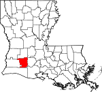
Jefferson Davis Parish, Louisiana Basics:


Jefferson Davis Parish Louisiana - Government Site

Population: 31,439
Area: 651 square miles
Parish seat: Jennings
Area code(s) in use: 337
Time zone: CST
High school graduate or higher: 77.9%
Bachelor's degree or higher: 12.0%
Median household income: $41,777
Persons in poverty: 18.1%
Home ownership rate: 76.5%
Mean travel time to work: 32.5 minutes


Adjacent counties:
Acadia  Allen  Beauregard  Calcasieu  Cameron  Evangeline  Vermilion  
Find in Louisiana

Map of the Jefferson Davis Parish area


Our detail map of Jefferson Davis Parish shows the Jefferson Davis Parish, Louisiana boundary lines and other interesting items.

Places in Jefferson Davis Parish, Louisiana

  Airports     show all on map

Aerolite Aero Park Ultralight Flightpark, Ag Aviation Airport, Jennings Airport, Koll Airport, Lake Air Service Airport, Light Plane Flyers Airfield, Lonesome Dove Airfield, Lyon Airport, Station 823 Heliport, Welsh Airport

  Areas     show all on map

Great Quelqueshoe Prairie

  Bays     show all on map

Francois Bay, Old River Bay

  Bends     show all on map

Dawson Bend, Marsh Bayou Cutoff, Old Barnes Creek Cutoff, Pinto Cutoff, Tom Bayou Cutoff

  Buildings     show all on map

Bayou Chene Volunteer Fire Department, Elton Fire Department, Elton Police Department, Golden Age Nursing Home of Welsh, Hathaway Fire Department, Jeff Davis Nursing Home, Jefferson Davis Parish Courthouse, Jefferson Davis Parish Criminal Court, Jefferson Davis Parish Fire District 5, Jefferson Davis Parish Fire District 7, Jefferson Davis Parish Health Unit, Jefferson Davis Parish Library, Jefferson Davis Parish Library Elton Branch, Jefferson Davis Parish Library Lake Arthur Branch, Jefferson Davis Parish Library McBurney Memorial Branch, Jefferson Davis Parish Office, Jefferson Davis Parish Police Jury, Jefferson Davis Parish Sheriff's Office, Jefferson Davis Parish Sheriff's Office - Narcotics Division, Jennings City Hall, Jennings Fire Department, Jennings Fire Department Substation, Jennings Police Department, Jennings Public Library, Kinder Police Department, Lacassine Volunteer Fire Department, Lake Arthur Fire Department, Lake Arthur Police Station, Lake Arthur Volunteer Fire Department, Rehabilitation Hospital of Jennings, Roanoke Volunteer Fire Department, Southwest Louisiana War Veterans Home, W H Tupper General Merchandise Museum, Welsh Police Department, Welsh Volunteer Fire Department, Woodlawn Volunteer Fire Department, Zigler Art Museum, Zigler Museum

  Canals     show all on map

Broadmore Ditch, Grand Canal, Holton and Winn Drainage Canal, Jennings Norwood Canal, Keystone Ditch, Louisiana Irrigation Canal, Niblett Canal, Southwestern Canal, Sturdivant Canal, Thornwell Drainage Canal, Tiptop Canal, Tiptop Canal, Welsh Canal, West Grand Marais Ditch

  Capes     show all on map

Gaithes Point

  Cemeteries     show all on map

Andress Cove Cemetery, Bertrand Cemetery, Broussard Cemetery, Calvary Cemetery, China Cemetery, Chretien Cemetery, Doucet Cemetery, Foreman Cemetery, Greenwood Cemetery, Herbert Cemetery, La France Cemetery, LaBleu Cemetery, Liberty Cemetery, Miller Cemetery, Nevils Cemetery, Pine Hill Cemetery

  Census     show all on map

Lacassine Census Designated Place, Roanoke Census Designated Place

  Channels     show all on map

Bird Bay Channel

  Churches     show all on map

Antioch Baptist Church, Bethel Baptist Church, Calvary Baptist Church, Calvary Baptist Church, Church of the Brethren, Faith Tabernacle, Fenton Baptist Church, First Assembly of God Church, First Baptist Church, First Baptist Church, First Baptist Church, First Baptist Church of Elton, First Church of Christ, First Pentecostal Church, First Presbyterian Church, First Presbyterian Church of Welsh, First United Methodist Church, First United Methodist Church, Golden Chain Baptist Church, Greater Saint Joseph Baptist Church, Immaculate Conception Catholic Church, Immanuel Lutheran Church, Immanuel Worship Center, Jennings Church of Christ, Jesus Worship United Pentecostal Church, Jones United Methodist Church, Kingdom Hall of Jehovahs Witnesses, Lambert Chapel Christian Methodist Episcopal Church, Living Word Assembly of God Church, Mount Pilgrim Baptist Church, Mount Triumph Baptist Church, New Jerusalem Baptist Church, New Life Tabernacle Pentecostal Church, Our Lady Help of Christians Catholic Church, Our Lady of Perpetual Help Church, Our Lady of Seven Dolors Church, Our Lady of the Lake Church, Our Savior's Church of Jennings, Raymond United Methodist Church, Roanoke United Methodist Church, Saint Ann Church, Saint Charles Borromeo Catholic Church, Saint Gertrude Church, Saint John Catholic Church, Saint Joseph Catholic Church, Saint Joseph's Church, Saint Lawrence Catholic Church, Saint Lukes Episcopal Church, Saint Paul Baptist Church, Saint Pauls Catholic Church, Song of Praise Church, The Church of Jesus Christ of Latter Day Saints, Topsy Baptist Church, Topsy United Pentecostal Church, Trinity United Methodist Church, Union Baptist Church, Union Baptist Church Family Life Center, United Pentecostal Church, Welsh Church of Christ, Welsh First United Methodist Church, Woodlawn Baptist Church

  Cliffs     show all on map

Grays Bluff

  Crossings     show all on map

Interchange 44, Interchange 48, Interchange 54, Interchange 59, Interchange 64, Interchange 65

  Dams     show all on map

Louisiana Noname 111 Dam

  Hospitals     show all on map

Jennings American Legion Hospital, Jennings Senior Care Hospital, Welsh General Hospital, Westend Hospital

  Islands     show all on map

Oak Island, Pine Island

  Locales     show all on map

Guinn Brothers Industrial Park, Jeff Davis Country Club, Jefferson Davis Parish Wastewater Treatment Plant, Jennings Airport Industrial Park, Jennings Golf Course, Jennings Shopping Center, Jennings Village Shopping Center, Jennings Wastewater Treatment Facility, Louisiana State University AgCenter Jefferson Davis Parish Office, Port of Jennings Industrial Park, Talens Marine and Fuel Lake Arthur Dock, Welsh Wastewater Treatment Plant

  Oilfields     show all on map

Andrus Cove Gas Field, Bon Air Oil Field, China Gas Field, East Lake Arthur Gas Field, East Roanoke Gas Field, Fenton Gas Field, Indian Village Oil Field, Lacassine Gas Field, Lake Arthur Oil and Gas Field, North Edna Oil Field, North Niblett Gas Field, North Welsh Gas Field, Northeast Bon Air Gas Field, Roanoke Oil and Gas Field, Rogers Bayou Gas Field, South Elton Oil and Gas Field, South Hayes Gas Field, South Jennings Oil and Gas Field, South Lake Arthur Gas Field, South Thornwell Gas Field, Southeast China Gas Field, Southeast Iowa Gas Field, Thompson Bluff Oil Field, Welsh Oil and Gas Field, West Edna Gas Field, West Lake Arthur Gas Field, West Lake Arthur Oil Field, West Mermentau Oil and Gas Field, West Tepetate Oil and Gas Field, Woodlawn Oil and Gas Field, Woodlawn Oil Field

  Parks     show all on map

North Cutting Park, Oil and Gas Park, Peters Street Playground, War Memorial Park, West End Park

  Populated Places     show all on map

Academy Mobile Village, Airport Mobile Home Park, Barnsdall, Buller, China, Daigle's Mobile Park, Edna, Elton, Fenton, Fontenot, Foremans Hall, Gravel Point, Hathaway, Jennings, Lacassine, Lake Arthur, McCutchen Mobile Home Haven, Niblett, Panchoville, Paradise Mobile Home Park, Pine Island, Raymond, Roanoke, Silverwood, Thornwell, Topsy, Welsh, Woodlawn

  Post Offices     show all on map

Coverdale Post Office (historical), Edna Post Office (historical), Elton Post Office, Fenton Post Office, Hutchinson Post Office (historical), Jennings Post Office, Lacassine Post Office, Lake Arthur Post Office, Niblett Post Office (historical), Roanoke Post Office, Thompson Post Office (historical), Thornwell Post Office (historical), Topsy Post Office (historical), Welsh Post Office, Woodlawn Post Office (historical)

  Ridges     show all on map

Wildcat Ridge

  Schools     show all on map

Bethel Christian School, Elton Elementary School, Elton High School, Fenton Elementary Junior High School, Hathaway High School, Jefferson Davis Parish Community Development Institute Head Start School, Jennings Elementary School, Jennings High School, Lacassine Elementary and High School, Lake Arthur Elementary School, Lake Arthur High School, Louisiana Technical College Morgan Smith Campus, Northside Junior High School (historical), Our Lady Immaculate School, Southside School, Ward Elementary School, Welsh Elementary School, Welsh High School, Welsh Roanoke Junior High School, West End Elementary School (historical)

  Streams     show all on map

Barnes Creek, Bayou Arceneaux, Bayou Chene, Bayou Queue De Tortue, Bayou Serpent, Cow Bayou, Dry Slough, East Bayou Grand Marais, East Bayou Lacassine, Greens Gully, Gum Bayou, Gum Gully, Hickory Gully, Little Bayou, Little Marsh Bayou, Marsh Bayou, Middle Bayou Grand Marais, Rogers Gully, Thompson Gully, Tom Bayou, West Bayou Grand Marais, West Bayou Lacassine

  Swamps     show all on map

Buller Marsh, Thompson Marsh

  Towers     show all on map

KAHJ-FM (Lake Arthur), KJEF-AM (Jennings), KJEF-FM (Jennings), KLTL-TV (Lake Charles), KPLC-TV (Lake Charles)

  Valleys     show all on map

Andress Cove,

Jefferson Davis Parish, Louisiana Population By Race (2012 estimate)

RacePopulation
WhiteJefferson Davis Parish White population 25,21425,214  
BlackJefferson Davis Parish Black population 5,4085,407
MixedJefferson Davis Parish Mixed population 534534
American IndianJefferson Davis Parish American Indian population 189188
AsianJefferson Davis Parish Asian population 9494
Hawaiian & Pacific IslanderJefferson Davis Parish Hawaiian & Pacific Islander population 00

Additional population tables :
State population table
Louisiana population by county