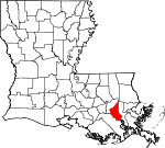
St. Charles Parish, Louisiana Basics:


St. Charles Parish Louisiana - Government Site

Population: 52,502
Area: 279 square miles
Parish seat: Hahnville
Area code(s) in use: 985
Time zone: CST
High school graduate or higher: 86.3%
Bachelor's degree or higher: 20.0%
Median household income: $59,197
Persons in poverty: 12.8%
Home ownership rate: 82.2%
Mean travel time to work: 27.0 minutes


Adjacent counties:
Jefferson  Lafourche  St. John Baptist  
Find in Louisiana

Map of the St. Charles Parish area


Our detail map of St. Charles Parish shows the St. Charles Parish, Louisiana boundary lines and other interesting items.

Places in St. Charles Parish, Louisiana

  Airports     show all on map

Moisart Heliport, St Charles Airport, Triche Field Airport, Waterford 3 Heliport

  Areas     show all on map

Grand Prairie Des Allemands

  Basins     show all on map

Davis Crevasse, Hymelia Crevasse

  Bays     show all on map

Bay Laurent

  Bridges     show all on map

Hale Boggs Memorial Bridge

  Buildings     show all on map

Bayou Gauche Volunteer Fire Department, Blessings From Above Daycare Center, Des Allemands Volunteer Fire Department, Des Allemands Volunteer Fire Department Station 71, Destrehan Plantation, East Saint Charles Volunteer Fire Department, East Saint Charles Volunteer Fire Department, East Saint Charles Volunteer Fire Department Station 1, Hahnville Volunteer Fire Department Station 31, Hahnville Volunteer Fire Department Station 32, Killona Volunteer Fire Department, Luling Living Center, Luling Volunteer Fire Department, Norco Area Volunteer Fire Department, Norco Area Volunteer Fire Department, Ormond Nursing and Care Center, Paradis Volunteer Fire Department, Saint Charles Parish Library, Saint Charles Parish Library East Regional Branch, Saint Charles Parish Library Hahnville Branch, Saint Charles Parish Library Norco Branch, Saint Charles Parish Library Saint Rose Branch, Saint Charles Parish Police Jury, Saint Charles Parish Sheriff's Office, Saint Charles Parish Sheriff's Office, Saint Charles Parish Sheriff's Office - Training, Saint Charles Specialty Rehabilitation Hospital, Saint Rose Volunteer Fire Department Station 51, Saint Rose Volunteer Fire Department Station 52, Sonshine Early Development Center, South Central Professional Development Center, Specialty Rehabilitation Hospital of Luling, Toddler House II Learning and Development Center

  Canals     show all on map

Bayou Couba Oil Field Canal, Blouin Canal, Burchell Canal, Canal Number Eight, Canal Number Eighteen, Canal Number Eleven, Canal Number Fifteen, Canal Number Five, Canal Number Four, Canal Number Fourteen, Canal Number Nine, Canal Number Nineteen, Canal Number Seven, Canal Number Seventeen, Canal Number Six, Canal Number Sixteen, Canal Number Ten, Canal Number Thirteen, Canal Number Three, Canal Number Twelve, Canal Number Twenty, Canal Number Twentyfour, Canal Number Twentyone, Canal Number Twentythree, Canal Number Twentytwo, Cousin Canal, Crawford Canal, Cross Bayou Canal, Duncan Canal, Eighty Arpent Canal, Ellington Canal, Flux Canal, Garland Canal, Grand Bayou Canal, Humble Canal, Hymel Canal, Johnson Canal, King Canal, Lanaux Canal, Lanaux Canal, Little Pecan Tree Canal, Louisa Canal, Louisiana Cypress Lumber Canal, Marys Canal, Paradis Canal, Pecan Tree Canal, Peterson Canal, Pointe Lavin Canal, Polete Canal, Providence Canal, Saint Charles Canal, Sellers Canal, Vial Canal, Victor Canal, Walker Canal

  Capes     show all on map

Pointe Cypres, Thirtyfive Mile Point, Twentysix Mile Point

  Cemeteries     show all on map

Bayou Gauche Cemetery, Green Hill Cemetery, Holy Rosary Cemetery, Jefferson Memorial Gardens, Montz Cemetery, Saint Charles Cemetery, Saint Charles Cemetery, Saint Marys Cemetery, Shell Mound Cemetery, Young Cemetery

  Census     show all on map

Ama Census Designated Place, Bayou Gauche Census Designated Place, Boutte Census Designated Place, Des Allemands Census Designated Place, Destrehan Census Designated Place, Hahnville Census Designated Place, Killona Census Designated Place, Luling Census Designated Place, Montz Census Designated Place, New Sarpy Census Designated Place, Norco Census Designated Place, Paradis Census Designated Place, Saint Rose Census Designated Place, Taft Census Designated Place

  Channels     show all on map

Bayou Couba, Bayou Gauche

  Churches     show all on map

Antioch Church, Barton Avenue Church of Christ, Bayou Gauche Church, Bell Baptist Church, Bible Center Church, Boutte Assembly of God Church, Christian Family Fellowship Church, Covenant Church, Des Allemands Baptist Church, Faith Praise and Deliverance Church, Faith Praise and Deliverance Church, Fifth African Baptist Church, First Assembly of God Church, First Baptist Church, First Baptist Church, First Baptist Church, First Union Presbyterian Church, Good Hope Missionary Baptist Church, Good Hope Presbyterian Church, Great Antioch Church, Greater Good Hope Baptist Church, Hahnville Baptist Church, Harvest Time Christian Center, Holy Family Catholic Church, Holy Rosary Church, King Jesus Ministries, Kingdom Hall Church, Life Fellowship Community Church, Luling United Methodist Church, Mount Airy Baptist Church, Mount Airy Church, Mount Zion Baptist Church, Mount Zion Baptist Church, Mount Zion Church, Philadelphia Baptist Church, Providence Baptist Church, River of Life Church, Sacred Heart of Jesus Church, Saint Anthony Catholic Church, Saint Charles Church, Saint Charles United Methodist Church, Saint Gertrude Catholic Church, Saint Isadore Church (historical), Saint James United Methodist Church, Saint Mark Catholic Church, Saint Mary Baptist Church, Saint Matthew Baptist Church, The Church of Jesus Christ of Latter Day Saints, Tru Vine Baptist Church, West Saint Charles Baptist Church

  Crossings     show all on map

Interchange 1, Interchange 10, Interchange 1A, Interchange 2, Interchange 6, Interchange 7

  Dams     show all on map

Bonnet Carre Spillway

  Flats     show all on map

Bonnet Carre Floodway

  Guts     show all on map

Bayou Bois Piquant, Bayou Crocodile, Bayou Cypriere Longue, Bayou de Sauce, Bayou des Saules, Bayou Petit, Bayou Piquant, Bayou Saut D'Ours, Grand Bayou

  Hospitals     show all on map

Saint Charles Parish Hospital

  Islands     show all on map

Black Prince Island, Couba Island, Martins Island

  Lakes     show all on map

Baie des Chactas, Baie du Cabanage, Davis Pond, Lake Cataouatche, Lake Salvador, Petit Lac Des Allemands, Simoneaux Ponds

  Levees     show all on map

Lower Guide Levee, Luling Revetment, Upper Guide Levee, Waterford Revetment

  Locales     show all on map

Ama Station (historical), Bois Chactas Shell Bank, Boutte Shopping Center, Cypress Village Shopping Center, Fashion Golf Course, Good Hope Landing, Gypsy Plantation, Hahnville Landing, Hymelia Plantation, James Business Park, Mary Plantation, New Hope Plantation (historical), Ormand Landing, Ormond Country Club, Ormond Landing, Pecan Grove Landing, Rehan Wastewater Treatment Plant, Riverbend Business Park, Saint Charles Plaza, Saint Rose Landing, Trinity Plantation, Ville Wastewater Treatment Plant, Willowdale Country Club

  Oilfields     show all on map

Bayou Couba Oil and Gas Field, Bayou Villars Oil Field, Boutte Oil and Gas Field, Couba Island Oil Field, East Good Hope Gas Field, Gold Mine Gas Field, Good Hope Oil and Gas Field, Lacs Des Atlemands Gas Field, Lake Des Allemands Oil and Gas Field, Lake Lucy Gas Field, Lake Salvador Oil Field, Lucy Gas Field, Lucy Gas Field, Martin Island Gas Field, Norco Oil and Gas Field, North Saint Rose Gas Field, Paradis Oil and Gas Field, South Taft Gas Field, West Avondale Gas Field (historical)

  Parks     show all on map

Ama Park, Bethune Park, Imtt Field, Lagattuta Park, Montz Park, Saint Charles Parish Park, Saint Charles Parish Park

  Populated Places     show all on map

Almedia, Ama, Bayou Gauche, Boutte, Camardelle, Chaudiere Casse, Corso, Davis (historical), Davis Plantation, Des Allemands, Destrehan, Dufresne, Ellington, Flagville, Frellsen, Good Hope, Green Acres, Hahnville, Kellogg, Killona, La Branche, Lone Star, Loquer (historical), Luling, Mimosa Park, Montz, New Sarpy, Norco, Paradis, Pecan Grove (historical), Prospect, Riverland Mobile Home Park, Rost, Saint Rose, Salix, Sarpy (historical), Sellers, Tabatiere Perdue, Taft, Vallier, Waterford

  Post Offices     show all on map

Ama Post Office, Boutte Post Office, Des Allemands Post Office, Destrehan Post Office, Good Hope Post Office (historical), Killona Post Office, La Branch Post Office (historical), Luling Post Office, Moberly Post Office (historical), Montz Post Office (historical), New Sarpy Post Office, Norco Post Office, Paradis Post Office, Saint Rose Post Office, Taft Post Office (historical)

  Reserves     show all on map

Salvador State Wildlife Management Area

  Schools     show all on map

A A Songy Sr Kindergarten Center School, Albert Cammon Middle School, Allemands Elementary School, Bethune High School, Boutte Christian Academy School, Boutte School, Destrehan High School, Destrehan High School (historical), East Bank Head Start Center, Ethel Schoeffner Elementary School, George Washington Carver Early Learning Center School, Grace Kids Day Care Center, Hahnville High School, Hahnville School, Harry M Hurst Middle School, J B Martin Middle School, J B Martin Middle School, Killona School (historical), Lakewood Elementary School, Luling Elementary School, Mimosa Park Elementary School, New Sarpy Elementary School, New Sarpy Kindergarten Center, Norco Elementary School 4-6, Norco Elementary School K-3, Norco School (historical), Pecan Grove School (historical), R J Vial Elementary School, R J Vial School, R K Smith Middle School, Sacred Heart of Jesus Catholic School, Saint Charles Borromeo Elementary School, Saint Charles Parish Alternative School, Saint Charles Parish Satellite Center School, Saint Rose Elementary School, Small World Day Care and Learning Center

  Streams     show all on map

Bayou des Saules, Bayou La Branche, Bayou Pain, Bayou Traverse, Bayou Trepagnier

  Swamps     show all on map

Bird Island, Cypress Island, Johnson Island, Summers Island, Victor Island

  Towers     show all on map

WADU-AM (Norco),

St. Charles Parish, Louisiana Population By Race (2012 estimate)

RacePopulation
WhiteSt. Charles Parish White population 37,11937,118  
BlackSt. Charles Parish Black population 13,96613,965
MixedSt. Charles Parish Mixed population 735735
AsianSt. Charles Parish Asian population 525525
American IndianSt. Charles Parish American Indian population 210210
Hawaiian & Pacific IslanderSt. Charles Parish Hawaiian & Pacific Islander population 00

Additional population tables :
State population table
Louisiana population by county