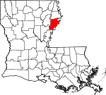
Tensas Parish, Louisiana Basics:
Tensas Parish Louisiana - Government Site
Population: 4,972
Area: 603 square miles
Parish seat: Saint Joseph
Area code(s) in use: 318
Time zone: CST
High school graduate or higher: 75.4%
Bachelor's degree or higher: 10.5%
Median household income: $29,888
Persons in poverty: 30.9%
Home ownership rate: 63.1%
Mean travel time to work: 18.1 minutes
Adjacent counties:
Adams (MS) Catahoula Claiborne (MS) Concordia Franklin Jefferson (MS) Madison Warren (MS)
Places in Tensas Parish, Louisiana
Ag Air Incorporated Airport,
Kifer Airport,
Myrtle Grove Airport,
Norris Airstrip,
Tensas Flying Service Airport,
Tensas Parish Airport,
Tensas Parish Airport The Glade Panola Bar,
Waterproof Bar Buckridge Crevasse,
Winter Quarters Crevasse Hard Times Bend,
Kempe Bend,
Newtown Bend,
Ridge Lake Bend,
Rodney Bend,
Rodney Cutoff Hubbard Bridge Bieller Light,
Dishroon Post Light,
Tensas Parish Fire District 1 Station 1,
Tensas Parish Fire District 1 Station 10,
Tensas Parish Fire District 1 Station 2,
Tensas Parish Fire District 1 Station 3,
Tensas Parish Fire District 1 Station 4,
Tensas Parish Fire District 1 Station 5,
Tensas Parish Fire District 1 Station 6,
Tensas Parish Fire District 1 Station 7,
Tensas Parish Fire District 1 Station 8,
Tensas Parish Fire District 1 Station 9 Grudge Ditch,
Lake Saint Peter Canal,
Routh Ditch,
Yucatan Ditch Coffee Point,
Cooter Point,
Kings Point,
Point Pleasant Bland Cemetery,
Burn Cemetery,
Canton Cemetery,
Cross Keys Cemetery,
Elder Shade Cemetery,
Elk Ridge Cemetery,
Gold Bell Cemetery,
Helena Cemetery,
Jordan Cemetery,
Lakewood Cemetery,
Lemy Cemetery,
Loam Land Cemetery,
Mayflower Cemetery,
Mound Cemetery,
Myrtle Grove Cemetery,
Newell Cemetery,
Newellton Cemetery,
Oneonta Cemetery,
Powells Cemetery,
Routhwood Cemetery,
Saint Antioch Cemetery,
Saint John Cemetery,
Saint Joseph Cemetery,
Saint Matthew Cemetery,
Somerset Cemetery,
Tensas Cemetery,
Thistle Ridge Cemetery,
Winona Cemetery,
Wyoming Cemetery Bondurant Chute,
Killikrankia Cutoff,
Waterproof Cutoff Alphenia Church,
Bethany Baptist Church,
Broadroom Church,
China Grove Church,
Choctaw Baptist Church,
Church of Christ,
Church of God (historical),
Cypress Grove Church,
Flowery Mount Church,
Greenfield Church,
Greenfield Church,
Holly Ridge Church,
Jerusalem Church,
Lakewood Church,
Lower Tensas Church,
Magnolia Church,
Maryland Baptist Church,
Monclova Church,
Morning Star Church,
Mound Hedren Church,
Mount Nebo Church,
New China Grove Church,
New Hope Church,
New Zion Church,
Oneonta Church,
Paradise Church (historical),
Pleasant Green Church,
Pleasant View Church (historical),
Richland Church,
Saint Antioch Church (historical),
Saint Church,
Saint John Church,
Saint John Church,
Saint Joseph Church of God,
Saint Joseph United Methodist Church,
Saint Lena Church,
Saint Luke Church,
Saint Mark Church,
Saint Mark Church,
Saint Matthew Church,
Saint Paul Church (historical),
Saint Peter Church,
Saint Peter Church,
Shackleford Church,
Shackleford Church,
Shilake Church,
Shiloh Baptist Church,
Solomon Church,
Spring Hill Church,
Springfield Church,
Spurgeon Church (historical),
Villa Clara Church,
Waterproof United Methodist Church,
Wesley Church,
Zion Church (historical) Hog Glade Alligator Slough,
Andrews Bayou,
Bayou Bruin,
Bayou du Rosset,
Bengal Slough,
Bieler Bayou,
Big Bayou,
Big Slough,
Black Bayou,
Boggy Bayou,
Bridgie Bayou,
Buffalo Bayou,
Caney Bayou,
Choctaw Bayou,
Clark Bayou,
Clark Bayou,
Cow Slough,
Crooked Bayou,
Cross Bayou,
Cypress Bayou,
Dry Bayou,
Du Rosset Bayou,
Frenches Bayou,
Green Bayou,
Hayes Bayou,
Jordan Bayou,
Little Choctaw Bayou,
McPherson Bayou,
Mound Bayou,
Negro Bayou,
Routh Bayou,
Sandy Bayou,
Sandy Bayou,
Snake Bayou,
Steep Bank Bayou,
Three Buck Bayou,
Van Buren Bayou,
Wildhorse Bayou,
Young Bayou Bondurant Towhead,
Island Number Onehundred and Twelve,
Rodney Island,
Togo Island Allen Lake,
Bar Lake,
Bayou Vidal,
Bell Lake,
Big Lake,
Big Lake,
Big Lake,
Big Pond,
Black Lake,
Blue Hole,
Blue Hole,
Boggy Lake,
Bowman Lake,
Broad Lake (historical),
Brushy Lake,
Brushy Lake,
Brushy Lake,
Brushy Lake,
Brushy Lake,
Brushy Lake,
Bryland Lake,
Cindy Lake (historical),
Cypress Grove Lake,
Daniel Lake,
Dishroon Lake,
Duck Lake,
Duck Lake,
Duck Lake,
Duck Pond,
Fish lake (historical),
Fletchers Lake,
Fletchers Lake,
Fool Lake,
Fox Lake,
Gin Lake,
Gin Lake,
Glade Bayou,
Glade Bayou,
Gorton Chute,
Grassy Lake,
Hopaka Lake,
Horseshoe Lake,
Hunter Lake,
Jackson Lake,
Johnson Lake,
Kings Point Lake,
Lake Black Dog,
Lake Bruin,
Lake Formosa,
Lake Lakanardia,
Lake Marydale,
Lake Misery,
Lake Saint Joseph,
Lake Shallow,
Levi Lake,
Little Cypress Grove Lake,
Little Flag Lake,
Little Fletchers Lake,
Little Johnson Lake,
Little Lake,
Little Tensas Bayou,
Lockner Lake (historical),
Lodge Lake,
Long Lake,
Long Lake,
Mackey Lake,
May Lake,
Mile Lake,
Mill Lake,
Miller Lake,
Molen Lake,
Mossy Lake,
Mound Bayou,
Mound Bayou,
Mud Lake,
Mud Lake,
Old River Lake,
Palmyra Lake,
Phelps Bayou,
Pumping Station Slough,
Reed Lake,
River Sticks,
Rodney Lake,
Round Lake,
Saddletree Lake,
Shackleford Lake,
Shady Bradley Lake,
Shelley Lake,
Skeeter Lake,
Skinner Lake,
Snodgrass Lake,
Tensas Lake,
Trusler Lake,
Turkey Lake,
Turkey Lake,
Viney Lake,
Watermelon Lake,
White Oak Lake,
Wilson Lake,
Yucatan Lake,
Yucatan Lake Bondurant Towhead Dikes,
Browns Field Revetment,
Coffee Point Dikes,
Cottage Bend Revetment,
Hard Times Bend Revetment,
Hardscrabble Revetment,
Kempe Bend Revetment,
Lake Karnac Revetment,
Old Kempe Bend Revetment,
Waterproof Dikes (historical) Arcola Plantation,
Ashwood Landing,
Avondale Plantation,
Belleview Plantation,
Black Water Plantation,
Bondurant Landing,
Botany Bay Plantation,
Buckridge Landing,
Buckridge Light,
Burn Landing,
Burn Plantation,
Delta Bridge,
Duck Pond Plantation,
Durango Landing (historical),
Durango Plantation,
Flowers Ferry,
Franklin Spur (historical),
Gibson Plantation,
Gladstone Landing,
Goldman Lower Landing,
Hopkins Plantation,
Ione Plantation,
Jordan Ferry,
L'Argent Landing,
Lakewood Plantation,
Locust Ridge Plantation,
Marydale Plantation,
MAryland Plantation,
McLemores Shopping Center,
Mound Plantation,
Mount Ararat Plantation,
Newfoundland Plantation,
Oneonta Plantation,
Panola Plantation,
Raritan Plantation,
Ridgeland Plantation,
Saint Joseph Lower Landing,
Saint Joseph Upper Landing,
Somerset Landing,
Somerset Plantation,
Sunnybank Plantation,
Sunnyside Plantation,
Thistle Ridge Plantation,
Togo Landing,
Velverton Plantation,
Waterproof Landing,
Wavertree Plantation,
Winona Plantation,
Winter Quarters Plantation,
Woodburn Plantation,
Wyoming Plantation Aubrey Oil and Gas Field,
Buckhorn Oil Field,
Chamblee Gas Field,
Crimea Gas Field,
Delta Bridge Oil and Gas Field,
Fox Lake GAs Field,
Glade Bayou Oil Field,
Hard Bargin Gas Field,
Helena Oil Field,
Helena Oil Field,
Holly Ridge Gas and Oil Field,
Justina Gas Field,
Killens Ferry Gas Field,
Lake Formosa Oil Field,
Lake Saint John Oil and Gas Field,
Locust Ridge Oil Field,
New Quarters Oil Field,
Newlight Oil,
North Holly Ridge Oil Field,
North Lake Marydale Oil Field,
Northeast Lake Saint John Gas Field,
Pecan Landing Oil Field,
Rodney Island Oil Field,
Sundown Oil Field,
West New Quarters Oil Field,
West Newlight Oil and Gas Field Big Lake State Wildlife Management Area,
Lake Bruin State Park,
Saint Joseph Historic District,
Winter Quarters State Historic Site Alphenia Landing,
Anchor Landing,
Ashland,
Ashville (historical),
Aubrey,
Avondale,
Azucena,
Balmoral,
Barcelona,
Chamblee,
Consuella (historical),
Cooter Point,
Cooters Landing,
Crescent Landing,
Crimea,
Cross Keys,
Dearborn,
Denhart,
Denmark Landing,
Dixie (historical),
Eltringham Landing,
Ferry Newlight Landing,
Glade Bayou Landing,
Goldman,
Goldman Landing,
Gretna Green,
Hedgeland,
Helena,
Highland,
Holly Ridge,
Hopewell Landing,
Justina,
Kirks Landing,
Lake Bruin,
Locust Ridge,
Luckett (historical),
Martins Landing,
Maryland,
Mayflower,
Millerfield (historical),
New Carthage (historical),
New Quarters,
Newellton,
Newlight,
Notnac,
Oak Dale Landing,
Olympic Landing,
Osceola,
Pecan Landing,
Remolina Landing,
Richland,
Saint John,
Saint Joseph,
Saranac,
Shady Grove,
Somerset,
Tensas,
Tensas Bluff,
Tensas Bluff Landing,
Troy,
Waterproof,
Westwood,
Wildcat,
Wilsonia,
Young Landing,
Yucatan Landing Ashwood Post Office (historical), Barcelona Post Office (historical), Buck Ridge Post Office (historical), Choctaw Post Office (historical), Delta Bridge Post Office (historical), Ettringham Post Office (historical), Goldman Post Office (historical), Hard Times Landing Post Office (historical), Highland Post Office (historical), Locust Ridge Post Office (historical), Marydale Post Office (historical), Monticello Post Office (historical), Mound Bayou Post Office (historical), New Carthage Post Office (historical), New Light Post Office (historical), Newellton Post Office, Notnac Post Office (historical), Oneonta Post Office (historical), Point Pleasant Post Office (historical), Quimby Post Office (historical),
Saint Joseph Post Office, Stelia Post Office (historical), Waterproof Post Office
Buck Ridge,
Independent Ridge,
Newells Ridge Lakewood School (historical),
Lisbon Elementary School (historical),
Loam Land School,
Magnolia School,
Mount Nebo School (historical),
Newellton Elementary School,
Ruthwood Elementary School,
Saint Antioch School (historical),
Tensas Academy School,
Tensas Elementary School,
Tensas High School,
Tensas Parish Training School (historical),
Waterproof High School Beck Bayou,
Big Bayou,
Big Choctaw Bayou,
Black River,
Burnett Chute,
Dickard Bayou,
Dorthy Slough,
Gum Ridge Chute,
Harper Bayou,
Little Choctaw Bayou,
Little Roaring Bayou,
Muddy Bayou,
Nable Bayou,
Palmetto Slough,
Steep Bayou Big Hog Glade,
Brushy Lake,
Caney Bayou,
Cow Lake,
Gin Lake,
House Lake,
Lake Twentynine,
Long Lake,
Long Lake,
Pecan Brake,
Willow Lake,

