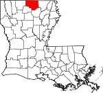
Union Parish, Louisiana Basics:
Union Parish Louisiana - Government Site
Population: 22,442
Area: 877 square miles
Parish seat: Farmerville
Area code(s) in use: 318
Time zone: CST
High school graduate or higher: 80.6%
Bachelor's degree or higher: 13.1%
Median household income: $36,507
Persons in poverty: 25.2%
Home ownership rate: 79.3%
Mean travel time to work: 30.8 minutes
Adjacent counties:
Ashley (AR) Claiborne Lincoln Morehouse Ouachita Union (AR)
Places in Union Parish, Louisiana
Peter Creek Ranch,
Union Parish Airport De Loutre Basin Buffalo Hole,
Davis Bend Bernice Volunteer Fire Department,
Farmerville Volunteer Fire Department,
Lillie Volunteer Fire Department,
Marion Volunteer Fire Department,
Point Wilhite Fire Department,
Rocky Branch Crossroads Fire Department,
Spearsville Volunteer Fire Department,
Spencer West Sterlington Fire District,
Ward 5 Volunteer Fire Department Abstent Cemetery,
Acree Cemetery,
Alabama-Weldon Cemetery,
Antioch Cemetery,
Antioch Cemetery,
Antioch Cemetery,
Barrett Cemetery,
Baughman Cemetery,
Beech Grove Cemetery,
Bernice Cemetery,
Bethel Cemetery,
Beulah Cemetery,
Birds Chapel Cemetery, Boatright Cemetery,
Brantley Cemetery,
Camp Creek Cemetery,
Canaan Cemetery,
Carter Cemetery,
Cedar Grove Cemetery,
Conway Cemetery,
Cook Cemetery,
Cook Cemetery,
Crossroads Cemetery,
Crow Cemetery,
Culbertson Cemetery,
Dean Cemetery,
Downsville Cemetery,
Edwards Cemetery,
Enterprise Cemetery,
Evergreen Cemetery,
Fairview Cemetery,
Feazel Cemetery,
Fellowship Cemetery,
Hard Shell Cemetery,
Holmesville Cemetery,
Hopewell Cemetery,
Jones Cemetery, Jordan Place Cemetery,
King Cemetery,
Laran Cemetery,
Liberty Cemetery,
Liberty Cemetery,
Macedonia Cemetery,
Morse Hill Cemetery,
Mount Olive Cemetery,
Mount Patrick Cemetery,
Old Tennessee Cemetery,
Parks Cemetery,
Pearson Cemetery,
Pilgrims Rest Cemetery,
Port Union Cemetery,
Rabun Cemetery,
Reppond Cemetery,
Reppond Cemetery,
Roark Cemetery,
Ruggs Bluff Cemetery,
Saint Pauls Cemetery,
Sardis Cemetery,
Shady Grove Cemetery,
Shiloh Cemetery,
Smyrna Cemetery,
Spencer Cemetery,
Spikner Cemetery,
Spillers Cemetery,
Spring Hill Cemetery,
Taylor Cemetery,
Terral Cemetery, Thomas Cemetery,
Thompson Cemetery,
Tubbs Cemetery,
Union Cemetery,
Union Grove Cemetery,
Wilhite Cemetery,
Zion Hill Cemetery Irwin Reach Alabama Methodist Church (historical),
Antioch Church,
Antioch Church,
Antioch Church of Christ,
Beech Grove Church,
Beech Grove Church,
Bethel Church,
Bethel Church,
Bird Chapel,
Camp Creek Church,
Canaan Church,
Center Branch Church,
Concord Church,
Crossroads Church,
Culbertson Church,
Enterprise Church,
Evergreen Church,
Evergreen Church,
Fairview Church,
Fellowship Church,
First United Church,
Good Hope Church,
Halls Church,
Holmesville Church,
Jerusalem Church,
Lanes Chapel,
Liberty Church,
Liberty Church,
Liberty Church,
Lingrove Church,
Little Hope Church,
Lone Star Church,
Lone Star Church,
Marion Church,
Meridian Church,
Millard Hill Church,
Mount Ararat Church,
Mount Ararat Church,
Mount Horeb Church,
Mount Nebo Church,
Mount Olia Church,
Mount Pisgah Church,
Mount Sharon Church,
Mount Sterling Church,
Mount Tabor Church,
Mount Union Church,
Mount Union Church,
New Land Church,
New Spring Hill Church,
Paron Church,
Patrick Church,
Pilgrim Church,
Pine Grove Church,
Pine Vale Church,
Pisgah Church,
Pleasant Grove Church,
Pleasant Hill Church,
Point Assembly of God Church,
Providence Church,
Saint John Church,
Saint Johns Chapel,
Saint Johns Church,
Saint Pauls Church,
Saint Pauls Church,
Salem Church,
Sardis Church,
Shady Grove Church,
Spring Hill Church,
Sweet Lily Church,
Sweet Union Church,
Union Church,
Union Church (historical),
Union Grove Church,
Wards Chapel,
Woodlawn Church,
Zion Hill Church,
Zion Hill Church,
Zion Watch Church Hollands Bluff Defees Ferry (historical),
Lowrys Ferry (historical),
Phillips Ferry Bayles Pond Dam,
Bayou Darbonne Dam,
Francis Creek Lake Dam,
Lejeune Pond Dam,
Lindsay Dam,
Ouchley Pond Dam,
Terral Dam Long Slough Serenity Springs Specialty Hospital,
Tri - Ward General Hospital,
Union General Hospital Big Island,
Hog Island,
Long Point Island,
Tenmile Island Big Lake,
Blasingame Brake,
Eagle Lake,
Finch Lake,
Fish Lake,
Harrell Lake,
Hatley Lake,
Henderson Lake,
Jones Lake Hollands Woodyard Landing,
Lake Drain Landing,
Ouachita Valley Council Scout Reservation,
Park,
Pinewood Camp Bayou D'Arbonne Gas Field,
Bernice Oil and Gas Field,
Bull Creek Gas Field,
Corney Bayou Oil Field,
D'Arbonne Gas Field,
Downsville Gas Field,
Drew Gas Field,
Lynn Creek Gas Field,
Marion Gas Field,
Mount Olive Oil and Gas Field,
Ora Oil Field,
Shiloh Gas Field,
South Downsville Gas Field,
Stowe Creek Gas Field,
Truxno Oil Field Bayou D'Arbonne Recreation Area,
Donaghey State Park,
Lake D'Arbonne State Park,
Union State Wildlife Management Area,
Union Wildlife Management Area,
Upper Ouachita National Wildlife Refuge Alabama Landing,
Bemis,
Bernice,
Bethel Springs,
Brantley Landing,
Canbeal,
Cane Ridge (historical),
Carroll (historical),
Cecil,
Cherry Ridge (historical),
Clayton (historical),
Colsons (historical),
Conway,
Copley,
Cox Ferry,
Crossroads,
Culbertson,
D'Arbonne,
De Loutre,
Dean,
Downsville,
Evergreen,
Farmerville,
Gravel,
Haile,
Holmesville,
Hooker Hole,
Hunt,
Junction City,
Laran,
Lillie,
Linville,
Litroe,
Loch Lomond,
Lockhart,
Loco,
Marion,
Monroe,
Moselys Bluff,
Mount Union,
Oakland,
Ouachita City,
Pisgah,
Point,
Port Union (historical),
Quigley,
Randolph,
Rocky Branch,
Rum Center,
Sadie,
Shiloh,
Shiloh Landing (historical),
Smurney,
Spearsville,
Spencer,
Taylortown,
Terrills,
Thirteen Points Landing,
Truxno,
Tugwell,
Upco,
Walnut Lane (historical),
West Sterlington,
Wilhite Alabama Post Office (historical), Bearden Post Office (historical),
Bernice Post Office, Bethel Springs Post Office (historical), Bunkerhill Post Office (historical), Callaway Post Office (historical), Cane Ridge Post Office (historical), Carroll Post Office (historical), Cecil Post Office (historical), Center Post Office (historical), Cherry Ridge Post Office (historical), Colsons Post Office (historical), Conway Post Office (historical), D'Arbonne Post Office (historical), De Loutre Post Office (historical), Dean Post Office (historical), Decatur Post Office (historical), Downsville Post Office, Earl Post Office (historical),
Farmerville Post Office, Haile Post Office (historical), Handy Post Office (historical), Hobson Post Office (historical), Holmesville Post Office (historical), Laran Post Office (historical),
Lillie Post Office,
Linville Post Office, Litroe Post Office (historical), Loch Lomomd Post Office (historical), Lockhart Post Office (historical), Lone Well Post Office (historical), Louter Post Office (historical),
Marion Post Office, Mars Hill Post Office (historical), Meridian Post Office (historical), Middlefork Post Office (historical), Moselys Bluff Post Office (historical), Oakland Post Office (historical), Ora Post Office (historical), Ouachita Post Office (historical), Pisgah Post Office (historical), Point Post Office, Port Union Post Office (historical), Raleigh Post Office (historical), Randolph Post Office (historical), Rester Post Office (historical), Rugg Post Office (historical), Ryan Post Office (historical), Sadie Post Office (historical), Shiloh Post Office (historical), Spearsville Post Office (historical),
Spencer Post Office, Thaxton Post Office (historical), Truxno Post Office (historical), Tucker Post Office (historical), Tugwell Post Office (historical), Union Crossroads Post Office (historical), Walnut Lane Post Office (historical), Willhite Post Office (historical)
Bayou D'Arbonne Lake,
Francis Creek Lake,
Lejeune Pond,
Lindsays Pond,
Ouchleys Pond,
Terral Lake Antioch School,
Bernice High School,
Center School,
Culbertson School,
Douglas School,
Downsville High School,
Farmerville Elementary School,
Farmerville High School,
Farmerville Junior High School,
Friendship School,
Lane School,
Lillie Middle School (historical),
Linville High School (historical),
Louisiana Technical College North Central Campus,
Marion High School,
Millard Hill School,
Mount Olive School,
Rocky Branch Elementary School (historical),
Spearsville High School,
Union Christian Academy School,
Union Parish School Away From School Bayou de Loutre,
Bear Creek,
Beaver Creek,
Beaver Creek,
Big Branch,
Big Cane Creek,
Big Creek,
Blanchard Creek,
Boatwright Creek,
Boggy Bayou,
Briny Bridge Creek,
Buckhorn Slough,
Bull Creek,
Camp Creek,
Cane Creek,
Cane Creek,
Carter Creek,
Carter Slough,
Cecil Creek,
Cook Creek,
Corney Bayou,
Coulee Creek,
Cypress Creek,
Davis Creek,
Dry Branch,
Dry Creek,
Dry Creek,
Dry Creek,
Edmonds Creek,
Edwards Creek,
Farrar Branch,
Finch Bayou,
Fourmile Creek,
Francis Creek,
Frank Lapere Creek,
Frank Lapere Creek,
Glaze Creek,
Haile Creek,
Hammock Creek,
Hay Branch,
Hollman Creek,
Horse Pen Creek,
Horse Trough Creek,
Hunnicutt Creek,
Hurricane Creek,
Jenks Branch,
Joe Edwards Creek,
Jones Bayou,
Judy Creek,
Lake Drain Slough,
Lee Creek,
Lick Creek,
Lick Creek,
Lion Creek,
Little Bayou de Loutre,
Little Cane Creek,
Little Corney Bayou,
Little Cornie Bayou,
Lonnie Branch,
Lowery Creek,
Mark Beach Bayou,
Meridian Creek,
Mile Branch,
Mill Creek,
Mill Creek,
Mill Creek,
Miller Creek,
Morgan Branch,
Odom Creek,
Owens Creek,
Owl Creek,
Peter Creek,
Pipe Creek,
Possum Bayou,
Potter Creek,
Railroad Branch,
Redden Creek,
Resinger Hollis Creek,
Rock Creek,
Rogers Creek,
Rufus Creek,
Smith Branch,
Spring Branch,
Steep Bank Creek,
Steep Bank Creek,
Steward Creek,
Tenmile Creek,
Tenmile Creek,
Tenmile Creek,
Thompson Branch,
Tick Creek,
Tiger Creek,
Tucker Creek,
Turkey Creek,
Village Creek,
Wynn Branch Jim Nolan Brake,
Phillips Lake D'Arbonne Lookout Tower,
KTDL-AM (Farmerville),
KWJM-FM (Farmerville),
Linville Lookout Tower,
Oakland Lookout Tower,
Spearsville Lookout Tower,

