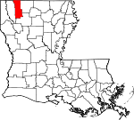
Webster Parish, Louisiana Basics:
Webster Parish Louisiana - Government Site
Population: 40,920
Area: 593 square miles
Parish seat: Minden
Area code(s) in use: 318
Time zone: CST
High school graduate or higher: 77.8%
Bachelor's degree or higher: 13.6%
Median household income: $35,896
Persons in poverty: 21.6%
Home ownership rate: 69.1%
Mean travel time to work: 24.5 minutes
Adjacent counties:
Bienville Bossier Claiborne Columbia (AR) Lafayette (AR)
Places in Webster Parish, Louisiana
Minden Airport,
Sharp Field Airport,
Springhill Airport Bistineau Gasoline Plant (historical),
Cullen City Hall,
Cullen Fire Protection District 6 Station 1,
Cullen Fire Protection District 6 Station 2,
Cullen Fire Protection District 6 Station 3,
Dixie Inn Volunteer Fire Department,
Evergreen Fire Department,
Fountain View Nursing Home,
Heflin Volunteer Fire Department,
Jones Memorial Public Library,
Meadowview Nursing Home,
Minden City Hall,
Minden Civic Center,
Minden Fire Department Station 1,
Minden Fire Department Station 2,
Minden Fire Department Station 3,
Minden Public Library,
Sarepta Fire District 5 Station 1,
Sarepta Fire District 5 Station 2,
Shongaloo Volunteer Fire Department,
Sibley Volunteer Fire Department,
Springhill City Hall,
Springhill Civic Center,
Springhill Police Station,
Springhill Public Library,
Town and Country Nursing Home,
Webster Parish Courthouse,
Webster Parish Fire District 10,
Webster Parish Fire District 3 Doyline Fire Department,
Webster Parish Fire District 7 Storage Facility,
Webster Parish Fire District 8 Station 1,
Webster Parish Fire District 8 Station 2,
Webster Parish Fire District 8 Station 3,
Webster Parish Fire District 8 Station 4,
Webster Parish Fire Protection District 11 Springhill Fire District Station 1,
Webster Parish Fire Protection District 11 Springhill Fire District Station 2,
Webster Parish Fire Protection District 11 Springhill Fire District Station 3,
Webster Parish Fire Protection District 4 Gusta Point Allen Cemetery,
Andrew Cemetery,
Banks Cemetery,
Baten Cemetery,
Beck Cemetery,
Boucher Cemetery,
Burns Cemetery,
Bush Cemetery,
Coyle Cemetery,
Coyle Cemetery,
Coyle Cemetery,
Crow Cemetery,
Crowe Cemetery,
Edwards Cemetery,
Fellowship Cemetery,
Flaherty Cemetery,
Fuller Cemetery,
Fuller Memorial Shrine Cemetery,
Game Cemetery,
Garden of Memory Cemetery,
Garden of Memory Cemetery,
Germantown Cemetery,
Gilmer Cemetery,
Growing Valley Cemetery,
Gryder Cemetery,
Haynes Cemetery,
Hodge Cemetery,
Hodges Cemetery,
Holoman Cemetery,
Hudson Cemetery,
Jim Davis Cemetery,
Keene Cemetery,
Kennon Cemetery,
Knottingham Cemetery,
Lane Memorial Cemetery,
Minden Cemetery,
Mount Zion Cemetery,
Newsom Cemetery,
Old Shongallo Cemetery,
Overton Cemetery,
Pilgrim Rest Cemetery,
Pilgrims Rest Cemetery,
Pleasant Grove Cemetery,
Pleasant Valley Cemetery,
Raine Cemetery,
Ratcliff Cemetery,
Richardson Cemetery,
Saint James Cemetery,
Saint Luke Cemetery,
Saint Moriah Cemeteries,
Saint Peter Cemetery,
Sandin Cemetery,
Shady Grove Cemetery,
Shiloh Cemetery,
Slack Memorial Cemetery,
Springhill Cemetery,
Taylor Cemetery,
Timothy Cemetery,
Union Cemetery,
Vanorsdale Cemetery,
Walker Cemetery,
Walker Cemetery,
Walker Cemetery,
Whispering Pines Cemetery Adams Church (historical),
Andrew Chapel (historical),
Antioch Baptist Church,
Antioch Church,
Beech Springs Baptist Church,
Bethel Faith Temple Church,
Beulahs Mount Church (historical),
Bistineau Baptist Church,
Blocker Church,
Blockers Chapel,
Blue Run Church,
Brushwood United Methodist Church,
Cedar Grove Church,
Central Baptist Church,
Church of Christ,
Church of God,
Cullen Assembly of God Church,
Dorcheat Acres Church,
Elizabeth Church,
Emanuel Church,
Evergreen Church,
Fellowship Baptist Church,
Ferguson Memorial Tabernacle (historical),
First Assembly of God Church,
First Baptist Church,
First Baptist Church,
First Pentecostal Church,
First Southern Methodist Church,
Full Gospel Church,
Germantown Baptist Church,
Gethsemane Family Church,
Greater Saint Paul Baptist Church,
Greenville Church,
Growing Valley Church,
Growing Valley Church,
Hires Chapel,
King Solomon Church,
Kings Corner Church,
Kirk Chapel,
Lakeview United Methodist Church,
Long Springs Church,
McIntyre Church,
Miller Chapel,
Miller Chapel,
Minden Church of Christ,
Minden Seventh Day Adventist Church,
Mount Calm Missionary Baptist Church,
Mount Comfort Church,
Mount Ealm Church,
Mount Morgan Church,
Mount Nebo Church,
Mount Olive Church,
Mount Pero Church,
Mount Pilgrim Church,
Mount Sariah Church,
New Hope Church,
New Light Missionary Baptist Church,
New Saint Luke Church (historical),
New Zion Church,
New Zion Church,
Old Sarepta Church,
Old Shongaloo Church,
Old Union Church,
Pilgrim Rest Baptist Church,
Pilgrims Rest Church,
Pine Grove Methodist Church,
Pleasant Hill Church (historical),
Pleasant Valley United Methodist Church,
Point Chapel,
Potter Church (historical),
Saint James Church (historical),
Saint Johns Church,
Saint Luke Church (historical),
Saint Marks Church,
Saint Marys Church,
Saint Matthew Church,
Saint Paul Catholic Church,
Saint Peter Church,
Saint Rose Church (historical),
Saints Rest Church,
Salem Church,
Sexton Church,
Shady Grove Church (historical),
Sheppard Heights Assembly of God Church,
Shiloh Church (historical),
Southside Baptist Church,
Springhill Christian Church,
Springhill Presbyterian Church,
Springhill United Methodist Church,
Springhill United Pentecostal Church,
Sweet Home Church,
Sykes Ferry Church (historical),
Temple Baptist Church,
Tillman Church,
Ulight Church,
Union Church,
Union Grove Church,
Union Grove Church,
Union Grove Church (historical),
Union Springs Church,
Valley Springs Church,
Vaughns Chapel (historical),
Whispering Pines Church,
White Rose Church Interchange 38,
Interchange 44,
Interchange 46,
Interchange 49,
Interchange 52,
Petes Ferry (historical) Empounding Basin Number 1 Dam,
H G Hayes Pond Dam,
John M Robinson Pond Dam,
Lower Caney Dam,
McDowell Pond Dam,
Murray Lake Annex Dam,
R D Hinton Pond Dam,
Shirley Willis Pond Dam,
Smith Pond Number Four Dam,
Smith Pond Number Three Dam,
Upper Caney Dam,
Williams Lake Dam,
Woodly Pond Dam Hickory Flat,
Oak Flat,
The Flats Big Slough,
Davis Slough Doctors Clinic,
Gray Clinic,
Minden Medical Center,
Springhill Medical Center Birds Island,
Crane Island,
Goat Island,
Lake Crane Island,
Little Crane Island,
Nancys Island,
Plum Orchard Island,
Sandy Island,
Snake Island Beaver Lake,
Crane Lake,
Wildcat Slough,
Williams Lake Alexandria Mill (historical),
Camp Yatasi,
Caney Creek Recreation Area,
Caney Lakes Recreation Site,
Dorcheat Lodge (historical),
Dyers Store (historical),
Gas Spur,
Gleason Store (historical),
Harvels Store (historical),
Hortmans Store (historical),
Johnsons Store (historical),
Long Reach Mill (historical),
Martins Store (historical),
North Webster Industrial District Park,
Ogden Spur (historical),
Parish Farm,
Pine Hills Country Club,
Pine Plaza Shopping Center,
South Main Mall Shopping Center,
Sykes Ferry,
Turners Store (historical),
Upper Caney Campground,
Wenks Landing,
Winford Spur Louisiana Army Ammunition Plant Gray Pit,
Juben Gravel Pit Cotton Valley Oil and Gas Field,
Dykesville Oil and Gas Field,
Minden Oil and Gas Field,
North Shongaloo Oil and Gas Field,
Red Rock Oil and Gas Field,
Shongaloo Oil and Gas Field,
Sibley Gas and Oil Field,
Springhill Oil Field Academy Park,
Babb Park,
Carldon Martin Park,
City Park,
Dauchite Park,
Ewell Park Recreation Center,
Fair Park Recreation Center,
Hinton Memorial Park,
Lake Bistineau State Park,
Ludwig Recreation Park,
Lumberjack Stadium,
McClanahan Park,
Melvin Boucher Park,
Minden Historic District,
Minden Tennis and Aquatic Center,
Randy McMahen Park,
Roosevelt Park,
Stewart Park,
Victory Park,
Webster Park,
West Side Recreation Area B and S Park Subdivision,
Baccus,
Buckhorn (historical),
Bunker,
Clifford,
Connells (historical),
Cotton Valley,
Couchwood,
Cullen,
Dayson,
Dixie Inn,
Dorcheat,
Doyline,
Dubberly,
East Side Subdivision,
Ecco,
Germantown,
Gifford,
Gilark,
Goodwill,
Grim,
Grove,
Heflin,
Hortman,
Invincible,
Lakewood Estates,
Leton,
Long Springs,
Martin Junction,
McIntyre,
Meadow Creek Ranch,
Meadow Creek Subdivision,
Midway,
Minden,
Nine Forks,
Noles Landing,
North Acres,
Old Shongaloo,
Overton (historical),
Pace,
Pine Hill Subdivision,
Placid (historical),
Plum Orchard Landing,
Port Boliver,
Porterville,
Robin Hood Subdivision,
Sarepta,
Shongaloo,
Sibley,
Springhill,
Swift,
Timothy (historical),
Treat,
White Way Subdivision,
Woodlawn,
Yellow Pine Bascom Post Office (historical), Blackman Post Office (historical), Buckhorn Post Office (historical), Clifford Post Office (historical), Cotton Valley Post Office, Couchwood Post Office (historical),
Cullen Post Office, Dorcheat Post Office (historical), Doyline Post Office, Dubberly Post Office, Elvie Post Office (historical), Ferry Post Office (historical), Ford Post Office (historical), Goodwill Post Office (historical), Grove Post Office (historical), Hearn Post Office (historical), Heflin Post Office, Hortman Post Office (historical), Irving Post Office (historical), Jefferson Post Office (historical), Lanesville Post Office (historical), Leton Post Office (historical), Martin Post Office (historical), McGinty Post Office (historical), Mecca Post Office (historical),
Minden Post Office, Ogilvie Post Office (historical), Pleasanton Post Office (historical), Sarepta Post Office, Shongaloo Post Office, Sibley Post Office, Sikes Ferry Post Office (historical),
Springhill Post Office, Swift Post Office (historical), Timothy Post Office (historical), Velma Post Office (historical), Yellow Pine Post Office (historical)
Caney Lakes,
Lower Caney Lake,
Murray Lake,
Paper Mill Pond,
Sandlin Lake,
Upper Caney Lake Adams School (historical),
Ambrose School (historical),
Antioch School,
Blockers School (historical),
Blue Run School,
Bodeau School (historical),
Brown Middle School,
Browning Elementary School,
Brushwood School (historical),
Brushy Creek School,
Central Elementary School,
Clifford School (historical),
Concord School,
Cotton Valley High School,
Davis School (historical),
Doyline High School,
Dubberly Elementary School (historical),
E S Richardson Elementary School,
Galilee School,
Glenbrook School,
Growing Valley School,
Gum Spring School (historical),
Harkness School (historical),
Heflin Elementary School (historical),
Hope Youth Ranch Alternative Center School,
Hopewell School,
Howell Elementary School,
Howell School,
J A Phillips Middle School,
J E Harper Elementary School,
J L Jones Elementary School,
Jenkins School,
Lakeside Junior Senior High School,
Lindsey School (historical),
Long Springs School,
Louisiana Seminary,
Louisiana Technical College Northwest Campus,
Matthews School (historical),
Mims School (historical), Minden Female College (historical),
Minden High School, Minden Male Academy (historical),
Minden Seventh Day Adventists School,
Mount Perrow School,
New Hope School,
New Hortman School,
Oak Grove School (historical),
Pleasant College (historical),
Pleasant Grove School,
Potter School (historical),
Rhone School,
Rocky Comfort School (historical),
Rosenwald School,
Sarepta High School,
Shongaloo High School,
Sibley High School (historical),
Sibley School (historical),
Sims School (historical),
Springhill Christian Academy,
Springhill Junior Senior High School,
Stewart Elementary School,
Talton School (historical),
Thomasville School,
Tony School (historical),
Turners School (historical),
Union Elementary School,
Union Springs School (historical),
Valley Springs School,
Webster Junior High School,
Webster Parish Achievement Center School,
Webster Parish Adult Education Center School,
Webster Parish Expulsion School,
Webster Parish Special Learning Center Sulphur Springs Bayou Dorcheat,
Black Bayou,
Black Bottom Branch,
Boone Creek,
Braley Creek,
Brushy Creek,
Brushy Creek,
Butler Creek,
Caney Creek,
Caney Creek,
Canon Creek,
Cooley Branch,
Cooley Creek,
Cow Creek,
Crooked Creek,
Cypress Creek,
Dry Creek,
Fellowship Branch,
Fiddler Creek,
Flat Lick Bayou,
French Creek,
Glass Creek,
Gray Creek,
Hall Branch,
Hicks Branch,
Holder Creek,
Howell Creek,
Hurley Branch,
Indian Creek,
Leonard Branch,
Lick Creek,
Little Crooked Creek,
Little Indian Creek,
Mile Creek,
Mud Branch,
Near Creek,
Parmers Creek,
Prairie Bayou,
Red Rock Branch,
Sausman Creek,
Sugar Creek,
Tanyard Creek,
Taylor Branch,
Thorny Branch Big Mound,
Bull Hill,
Duncan Hill,
Indian Mound Dutchtown Lookout Tower,
Germantown Lookout Tower,
Germantown Lookout Tower,
KASO-AM (Minden),
KASO-FM (Minden),
KBSF-AM (Springhill),
KTKC-FM (Springhill),
Shongaloo Lookout Tower Sugarcane Trail,

