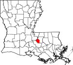
West Baton Rouge Parish, Louisiana Basics:


West Baton Rouge Parish Louisiana - Government Site

Population: 24,092
Area: 192 square miles
Parish seat: Port Allen
Area code(s) in use: 225
Time zone: CST
High school graduate or higher: 83.5%
Bachelor's degree or higher: 16.6%
Median household income: $50,788
Persons in poverty: 14.9%
Home ownership rate: 73.3%
Mean travel time to work: 22.9 minutes


Adjacent counties:
East Baton Rouge  East Feliciana  Iberville  Pointe Coupee  West Feliciana  
Find in Louisiana

Map of the West Baton Rouge Parish area


Our detail map of West Baton Rouge Parish shows the West Baton Rouge Parish, Louisiana boundary lines and other interesting items.

Places in West Baton Rouge Parish, Louisiana

  Airports     show all on map

La Coste Construction Co Airport, Omni Airport, Schexnayder Airport

  Basins     show all on map

Free Negro Point Crevasse

  Bays     show all on map

Whisky Bay

  Bends     show all on map

Mulatto Bend

  Buildings     show all on map

Addis Community Center, Addis Historical Museum, Addis Police Department, Addis Volunteer Fire Department Station 3 Main Station, Brusly Police Department, Brusly Town Hall, Brusly Volunteer Fire Department, Brusly Volunteer Fire Department, Erwinville Volunteer Fire Department, Lobdell Volunteer Fire Department, Port Allen Care Center, Port Allen Fire Department Station 1, Port Allen Fire Department Station 2, Port Allen Fire Department Station 3, Port Allen Police Department, Port Allen Police Department, Port Allen Railroad Depot Museum, Rosehill Volunteer Fire Department Station 2, West Baton Rouge Museum, West Baton Rouge Parish Courthouse, West Baton Rouge Parish Health Unit, West Baton Rouge Parish Library, West Baton Rouge Parish Office, West Baton Rouge Parish Parks and Recreation Community Center, West Baton Rouge Parish Public Works, West Baton Rouge Sheriff's Office

  Canals     show all on map

Choctaw Basin Drainage Canal, Port Allen Canal

  Capes     show all on map

Free Negro Point, Manchac Point, Point Menoir, Solitude Point

  Cemeteries     show all on map

Alford Cemetery, Allendale Cemetery, Antioch Baptist Cemetery, Benevolent Society Cemetery, Glennon Cemetery, Greater Shiloh Missionary Cemetery, Mount Olive Cemetery, Saint Catherine Cemetery, Saint John Cemetery, Silvery Cemetery, Westover Cemetery

  Census     show all on map

Erwinville Census Designated Place

  Channels     show all on map

Gulf Intracoastal Waterway

  Churches     show all on map

Addis Baptist Church, Addis Church, Antioch Church, Brown Church, Bueche Church, Calvary Church, Charismatic Fellowship Church, Christ Baptist Church, Church of Christ, First Baptist Church, First Baptist Church of Port Allen, Gifield Baptist Church, Gilfield Church, Gloryland Baptist Church, Gloryland Church, Greater Saint Paul Baptist Church, Harvest Church, Holy Family Catholic Church, Holy Spirit Catholic Church, Israelite Baptist Church, Kingdom Hall, Kingdon Hall, Little Saint Paul Spiritual Church, Love Missionary Baptist Church, Mount Bethel Church, Mount Olive Church, Mount Zion Church, Nazarene Baptist Church, New Hope Baptist Church, New Hope Church, New Life Apostolic Church, New Mount Olive Missionary Baptist Church, New Poplar Grove Baptist Church, Pilgrim Church, Poplar Grove Baptist Church, River Ministries International Church, Rock Zion Baptist Church, Rock Zion Church, Saint Catherine Church, Saint Francis Church (historical), Saint John Baptist Church, Saint John the Baptist Catholic Church, Saint Mary African Methodist Episcopal Church, Saint Marys Church, Saint Pauls Church, Saint Peters Church, Saint Rock Church (historical), Scotts United Methodist Church, Sharon Church, Shiloh Baptist Church, Sunrise Baptist Church, Union Baptist Church, West Baton Rouge First Apostolic Church, West Baton Rouge Presbyterian Church, Westside Apostolic Fellowship Church, Zion Traveler Church

  Crossings     show all on map

Interchange 151, Interchange 153

  Dams     show all on map

Port Allen Lock

  Harbors     show all on map

Greater Baton Rouge Port

  Lakes     show all on map

Gar Pond, Green Lake, Lake Clause

  Levees     show all on map

Allendale Revetment, Arbroth Revetment, Missouri Bend Revetment

  Locales     show all on map

Addis Wastewater Treatment Plant, Allendale Plantation (historical), Anchorage Landing, Anchorage Plantation (historical), Arbroth Landing, Ashland Plantation (historical), Australia Landing, Australia Plantation (historical), Barroza Landing, Barroza Plantation (historical), Batture Plantation (historical), Belair Plantation (historical), Belle Vale Plantation (historical), Belmont Plantation (historical), Boulieu Plantation (historical), Brusly Wastewater Treatment Facility, Camp Plantation (historical), Carolina Plantation (historical), Catherine Landing, Cinclare Plantation (historical), Clara Belle Plantation (historical), Clarkland Plantation (historical), Comeaux Landing, Eliza Plantation (historical), Erwinville Wastewater Treatment Facility, Grossman Landing, Highland Plantation Landing, Hills Spur (historical), Home Plantation, Homestead Plantation (historical), Kelson Landing, Kelson Plantation (historical), Limerick Plantation (historical), Lobdell Landing, Lobdells Plantation (historical), Lukeville Lane Wastewater Treatment Plant, Medora Plantation (historical), Missouri Landing, Missouri Plantation (historical), New Hope Plantation, Oaks Plantation (historical), Orange Grove Plantation (historical), Point Place Landing, Port Allen Marine Service, Port Allen Marine Service, Red Eye Landing, Rose Hill Landing, Saint Delphine Landing, Saint Delphine Plantation, Saint Delphine Plantation, Saint Mary Plantation (historical), Smithfield Plantation (historical), Viola Plantation (historical), West Baton Rouge Parish Westport Wastewater Facility, West Side Golf Course

  Oilfields     show all on map

Bayou Choctaw Oil Field, Bayou Cholpe Oil Field, Cinclare Gas Field, East Lobdell Gas Field, Green Lake Oil and Gas Field, Green Lake Oil and Gas Field, Grosse Tete Gas Field, Lobdell Oil and Gas Field, Manchac Point Oil Field, Morrisonville Oil Field, Port Allen Oil Field, Rebecca Bayou Gas Field, Rebecca Bayou Oil Field, West Addis Oil Field

  Parks     show all on map

Alexander Park, Joe Myhand Park, Landen L Alexander Park, Rivault Memorial Park, Rivoult Memorial Park, Winterville Park, Winterville Park

  Populated Places     show all on map

Addis, Alfords, Allen Landing, Allendale, Anchorage, Antonio, Arbroth, B and K Mobile Park, Barroza (historical), Beaulieu, Belmont, Belmont Landing, Brusly, Brusly Landing, Bueche, Carey, Catherine, Catherine, Chamberlin, Chenango, Choctaw, Cinclare, Cinclare Landing (historical), Court Street Estates Mobile Home Park, Devalls, Dude's Trailer Park, Eliza, Erwinville, Frisco (historical), Ithra, Kahns, Lejeune, Lida Grove, Lobdell, Lobdell Station, Lukeville, Lynch, Lynn's Mobile Home Court, Mark (historical), Merlin, Morley, Mouchs Mobile Home Park, Mulatto Bend Landing, Myhand Mobile Home Park, Plantation Mobile Home Park, Poplar Grove Plantation, Port Allen, Port Allen Landing, Riverboat Lane Mobile Home Park, Rose Hill (historical), S and R Mobile Home Park, Saint Delphine, Sardine Point Settlement (historical), Smithfield, Sunrise, Walls, West Baton Rouge, Westover, Wilbert (historical), Yattan

  Post Offices     show all on map

Addis Post Office, Arbroth Post Office (historical), Brusly Post Office, Bueche Post Office, Chamberlin Post Office (historical), Cinclare Post Office (historical), Devall Post Office (historical), Erwinville Post Office, Gassie Post Office (historical), Ithra Post Office (historical), Kahns Post Office (historical), Lobdell Post Office (historical), Mark Post Office (historical), Morley Post Office (historical), Port Allen Post Office, Walls Post Office (historical), Westover Post Office (historical), Wilbert Post Office (historical)

  Schools     show all on map

Brusly Elementary School, Brusly High School, Brusly Middle School, Chamberlin Elementary School, Cohn Elementary School, Devall Middle School, Faith Academy School, Holy Family School, Kids Club Child Care and Learning Center, Kidz Karousel Day Care Center, Louisiana Technical College Port Allen Extension Campus, Lukeville Upper Elementary School, New Poplar Grove Baptist Church Day Care and Learning Center, Port Allen Elementary School, Port Allen High School, Port Allen High School, Port Allen Middle School, Port Allen Middle School, West Baton Rouge Vocational Skills Center (historical)

  Streams     show all on map

Alligator Bayou, Bayou Chalpin, Bayou Clause, Bayou Poydras, Bayou Tommy, Broussard Bayou, Cane Bayou, Cholpe Bayou, Erwin Bayou, Grand Bayou, Little Choctaw Bayou, Stumpy Bayou, Tiger Bayou

  Towers     show all on map

WGMB-TV (Baton Rouge), WIBR-AM (Baton Rouge), WJBO-AM (Baton Rouge), WLUX-AM (Baton Rouge), WLUX-AM (Port Allen), WTGE-FM (Baton Rouge), WTGE-FM (Baton Rouge), WTKL-AM (Baton Rouge), WVLA-TV (Baton Rouge), WXOK-AM (Baton Rouge), WYNK-AM (Baton Rouge), WYNK-FM (Baton Rouge),

West Baton Rouge Parish, Louisiana Population By Race (2012 estimate)

RacePopulation
WhiteWest Baton Rouge Parish White population 14,60014,599  
BlackWest Baton Rouge Parish Black population 9,0599,058
MixedWest Baton Rouge Parish Mixed population 265265
AsianWest Baton Rouge Parish Asian population 120120
American IndianWest Baton Rouge Parish American Indian population 4848
Hawaiian & Pacific IslanderWest Baton Rouge Parish Hawaiian & Pacific Islander population 00

Additional population tables :
State population table
Louisiana population by county