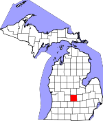
Clinton County, Michigan Basics:


Clinton County Michigan - Government Site

Population: 76,141
Area: 566 square miles
County seat: Saint Johns
Area code(s) in use: 517 989
Time zone: EST
High school graduate or higher: 92.7%
Bachelor's degree or higher: 27.8%
Median household income: $58,231
Persons in poverty: 11.2%
Home ownership rate: 81.3%
Mean travel time to work: 23.0 minutes


Adjacent counties:
Eaton  Gratiot  Ingham  Ionia  Montcalm  Saginaw  Shiawassee  

Find in Michigan

Map of the Clinton County area


Our detail map of Clinton County shows the Clinton County, Michigan boundary lines and other interesting items.

Places in Clinton County, Michigan

  Airports     show all on map

Abrams Municipal Airport, Archer Memorial Field Airport, Capital Region International Airport, Davis Airport, Dennis Farms Airport, Forest Hill Airport, Glowacki Airport, Hoerners Corners Airport, Randolph's Landing Area Airport, Schiffer Acres Airport, Tripp Creek Airport, University Airpark, Wisner Airport, Zischke Airport

  Buildings     show all on map

Bath Charter Township Fire Department, Bath Township Police Department, Briggs Public Library, Capital Region International Airport Fire Department, Capital Regional Airport Authority Police Department, City of Saint Johns Fire Department, Clinton Area Ambulance Service Authority, Clinton Area Fire and Rescue Station 1 Headquarters, Clinton Area Fire and Rescue Station 2, Clinton Area Fire and Rescue Station 3, Clinton Area Fire and Rescue Station 4, Clinton Area Fire and Rescue Station 5, Clinton County Courthouse, Clinton County Greenhaven Home, Clinton County Sheriff's Office, Dallas Township Fire and Rescue, Dewitt Area Emergency Services Authority, Dewitt Charter Township Fire Department Station 2, DeWitt Police Department, DeWitt Public Library, Dewitt Township Fire Department 1, Dewitt Township Police Department, Elsie Area Ambulance Service, Elsie Area Fire Department, Elsie Police Department, Elsie Public Library, Elsie Village Hall, Grange Hall, Looking Glass Regional Fire Authority, Mae Shady Nursery, Maple Rapids Library, Maple Rapids Police Department, Maple Rapids Volunteer Fire Department, Ovid - Middlebury Emergency Services Authority, Ovid Police Department, Ovid Public Library, Saint Johns Police Department, Westphalia Township Fire Department

  Canals     show all on map

Alward Lake Drain, Amspoker Drain, Baldwin and Muskrat Drain, Barrio Ditch, Baugh Gachter Drain, Bennett Drain, Blizzard Drain, Bond and Palmer Drain, Boughton Drain, Catlin and Waters Drain, Clavey Drain, Clise Drain, Coffman Drain, Connors and Sessions Drain, Cox Drain, Cutler and Walker Drain, Cutler Drain, Dallas and Bengal Drain, Devore Drain, Downer Drain, Duplain and Ovid Drain, Evert and Stewart Drain, Faiver Drain, Farrier Drain, Feneis Drain, Fisher Drain, Fowler Drain, Gillison Drain, Golden Gate Drain, Graneer Drain, Graneer Drain, Granger Drain, Gross and Taylor Drain, Hall Drain, Halstead Drain, Hayworth Drain, Henderson Drain, Hickok Drain, Husted Landenburg Drain, Jacob Drain, Jones Drain, Jury Drain, Kelley Drain, Kelley Drain, Kramer Drain, Lancaster Drain, Lehman Drain, Locher Drain, Long and Pierce Drain, Lowe Drain, Lyon and Dean Drain, Morris Drain, Nichols Drain, North Swargart Drain, Nuffer and Sturgis Drain, Openlander Drain, Pectil Drain, Piggott Drain, Prairie Creek and Gunderman Lake Drain, Reed Drain, Reynolds and Sessions Drain, Rochol Extension Drain, Rouse Drain, Sage and Hafner Drain, Schroeder Drain, Shadduck Drain, Sharps Drain, Sheldon Drain, Shepard Drain, Shulters and Stubbs Drain, Silm Drain, Silvernail Drain, Sleight Drain, Smith and Merchant Drain, Smith and Sutton Drain, Smith Drain, Stace Drain, Stevens Drain, Stewart and Kinley Drain, Sturgis Drain, Sturgis Drain, Summers Drain, Thelen Drain, Thome and Wieber Drain, Tibbetts Drain, Trent Drain, Turkey Creek Drain, Upton Drain, Wandeil Drain, Waters and Nash Drain, Watson and Summers Drain, Watson Drain, Westphalia and Riley Drain, Wieber Drain, Williams and Cook Drain, Wilson Drain, Yanz Drain

  Cemeteries     show all on map

Alward Lake Cemetery, Beech Cemetery, Blood Cemetery, Boughton Cemetery, Bray Cemetery, Chapel Hill Memorial Gardens, Cushman Family Cemetery, DeWitt Cemetery, Duplain Cemetery, East Plains Cemetery, Eddy Cemetery, Elsie Village Cemetery, Eureka Cemetery, French Road Cemetery, Frink Cemetery, Gardner Cemetery, Georgia Cemetery, Gunnisonville Cemetery, Hurd Cemetery, Lowe Cemetery, Maple Grove Cemetery, Maple Rapids Village Cemetery, Merihew Cemetery, Most Holy Trinity Cemetery, Mount Rest Cemetery, Niles Cemetery, North Eagle Cemetery, Oak Ridge Cemetery, Pleasant Hill Cemetery, Prairie Cemetery, Reed Cemetery, Richmond Cemetery, Riverside Cemetery, Rose Cemetery, Saint Marys Cemetery, Saint Pauls Cemetery, Saint Peter's Lutheran Cemetery, South Bingham Cemetery, South Ovid Cemetery, South Riley Cemetery, Stilson Cemetery, Stoll Cemetery, Union Home Cemetery, Wacousta Cemetery, Wager Cemetery, Wilsey Cemetery

  Census     show all on map

Bath Census Designated Place, Lake Victoria Census Designated Place, Wacousta Census Designated Place

  Churches     show all on map

Bath Baptist Church, Bath United Methodist Church, Bengal Church, Bible Church, Calvary Church, Christ United Church, Church of God, Church of Jesus Christ of Latter Day Saints, Church of the Bible Covenant, Church of the Living Word, Church of the Nazarene, Community Christian Church, Congregational Christian Church, DeWitt Christian Church, DeWitt United Brethren in Christ Church, Duplain Church of Christ, Eagle Foursquare Gospel Church, Eagle United Methodist Church, Eagle Wesley Chapel, Eureka Christian Church, Fenmore Baptist Church, First Baptist Church, First Baptist Church, First Baptist Church of God, First Baptist Church Swegles, First Church of God, First Congregational Church, First Pentecostal Church of God, First United Methodist Church, Free Methodist Church, Greenbush Church, Grove Bible Church, Gunnisonville United Methodist Church, Heritage Baptist Church, Highway Tabernacle, Hope Bible Baptist Church, Hope Lutheran Church, Jehovah's Witnesses, Lakeside Chapel, Lowe Church, Most Holy Trinity Church, Mount Hope Church-DeWitt, Mount Hope Saint Johns Family Church, Mount Zion Church, Northpoint Community Church, Pilgrim United Methodist Church, Price United Methodist Church, Psalm Ninety-One Church, Redeemer United Methodist Church, Reorganized Church of Jesus Christ of Latter Day Saints, Rose Lake Church, Saint Anne Church, Saint John's Episcopal Church, Saint Johns Lutheran Church, Saint Joseph Catholic Church, Saint Jude Catholic Church, Saint Mary's Catholic Church, Saint Paul Catholic Church, Saint Peter Lutheran Church, Sanctuary Gate Church, Seventh-Day Adventist Church, Shepardsville United Methodist Church, South Bingham Church, South Riley Church, Spirit of Christ Church, United Church of Ovid, United Methodist Church, United Methodist Church, Wacousta Community United Methodist Church, Wayside Chapel, Wesleyan Church

  Crossings     show all on map

Interchange 84, Interchange 86, Interchange 90

  Hospitals     show all on map

Clinton County Medical Center, Clinton Memorial Hospital, Delta Medical Center, DeWitt Family Practice, Elsie Family Health Care Center, Ingham Community Medical Center, Ovid Main Street Clinic, Saint Johns Family Health Center

  Lakes     show all on map

Aldrich Lake, Alward Lake, Blood Lake, Brindle Lake, Burke Lake, Cedar Lake, Curtis Lake, Fox Knoll Lake, Giffels Lake, Lake Geneva, Loon Lake, Montague Lake, Mud Lake, Mud Lake, Mud Lake, Muskrat Lake, Park Lake, Perch Lake, Potter Lake, Priggooris Lake, Richmond Lake, Rose Lake, Round Lake, Whitman Lake, Wolf Lake

  Locales     show all on map

A and M Farms, A and S Farms, Al Jo Farms, Anne Char Farms, Arens Brothers Dairy Farm, B K Ranch, Bailey Farms, Bancroft Farms, Bath Station (historical), Bear Foote Farm, Becker Farm, Bernath Farm, Blue Pine Dairy, Brandilyn Farm, Campbell Farms, Chardell Golf Course, Circle K Farm and Ranch, Clark Farms, Cloverbrook Farm, Crosby Mint Farm, DeWitt Family Golf Center, DeWitt Rest Area, DeWitt Rest Area, Double D Farm, Double M Farm, Dutch Meadows Dairy, E B Ridge Dairy, E R Dairy Farm, Eagle Eye Golf Club, Eagle Station (historical), Elsie Station, Emerald at Maple Creek Golf Course, Evergreen Dairy, Fabus Farms, Falcon Golf Course, Fitzpatrick Farms, Flegler Farms, Fowler Station (historical), Geller Beef Farms, Gingrich Farms, Goodrich Acres Strawberry Farm, Gove Farm, Grand Ledge Rest Area, Greenbush Farms, Harte Farms, Havengreen Organic Dairy, Havens Farms, Hawk Hollow Golf Course, Hengesbach Farms, Hickory Hill Farm, Highland Hills Golf Club, Hold Your Horses Ranch, Holstein Farm, Hufnagel Dairy, Huhn Farms, Ingersoll Station (historical), Jason Corners Farm, Kelley Farms, Kiesling Farms, Kurncz Farms, Lamers Farms, Latchaw Farms, Livingston Farms, M M Farms, Maple River Campground, Maple Valley Farms, Martin Farms, McPherson Farms, Merle Beach, Miller Brothers Farm, Nash Farms, Nobis Dairy Farms, Oak View Farm, Ovid Station (historical), P and H Farms, Peck Farms, Piggott Farms, Platte Farms, Pline Farms, Prairie Creek Golf Course, Reha Farms, Rich - Ro Farms, Rock N Oak Dairy, Rocky Island Farm, Royal Scot Golf Course, S and J Farms, Saint John's Onion Farm, Saint Johns Station (historical), Schafer Farms, Schneider Dairy Farm, Schneider Farms, Schrader Dairy, Schrader Farm, Shephardsville Station (historical), Sisung Farms, South Point Mall, Sperry Farm, Summer Farms, Swanson Farms, Sweetgrass Farm, T and H Dairy, Taylor Farm, Thelen Dairy, Thelen Farms, Triple H Farm, Twin Oaks Golf Course, Wadell Farms, Walter Farm, Werner Farm, West Bend Farms, Wieber Dairy, Willowbrook Farm, Wyrick Farm

  Mines     show all on map

Miller Pit

  Parks     show all on map

Bath School Disaster Historical Marker, First Congregational Church of Ovid Historical Marker, George D. Sowers House Historical Marker, Greenbush United Methodist Church Historical Marker, Gumaer Memorial Park, Gunnisonville Historical Marker, Gunnisonville United Methodist Church Historical Marker, Joshua Simmons II Historical Marker, Maple River State Game Area, Michigan's Capitol Historical Marker, Nichols Pointe Park, Orla McGuire Park, Padgett Park, Paine-Gillam-Scott House Historical Marker, Philip Orin Parmelee Historical Marker, Priggooris Park, Richard Park, Riverside Park, Rochester Colony Historical Marker, Rose Lake State Wildlife Research Area, Saint John's Church Historical Marker, Saint Mary's Parish Historical Marker, Sleepy Hollow State Park, Village of Ovid Historical Marker, Westphalia Settlement Historical Marker

  Populated Places     show all on map

Bath, Cadgewith Farms Mobile Home Park, Clinton Village, DeWitt, Duplain, Dutch Mills Mobile Home Park, Eagle, East DeWitt, Elsie, Eureka, Fowler, Gunnisonville, King Arthur Mobile Home Park, Kristana Mobile Home Park, Maple Rapids, Matherton, Meadows of Saint Johns Mobile Home Park, Oak Island Mobile Home Park, Ovid, Park Lake Mobile Home Court, Price, Riley, Rotunda Mobile Home Park, Saint Johns, Saint Johns Mobile Home Village, Shepardsville, South Riley, Valley Estates Mobile Home Park, Valley Farms, Wacousta, Westchester Heights, Westphalia

  Post Offices     show all on map

Bath Post Office, Bengal Post Office (historical), Corkin Post Office (historical), DeWitt Post Office, Duplain Post Office (historical), Eagle Post Office, East Essex Post Office (historical), Elsie Post Office, Essex Post Office (historical), Eureka Post Office, Fowler Post Office, Gardnier's Corners Post Office (historical), Geary Post Office (historical), Goss Post Office (historical), Gunnisonville Post Office (historical), Ingersoll Post Office (historical), Jessie Post Office (historical), Keystone Post Office (historical), Lebanon Post Office (historical), Lyon's Mill Post Office (historical), Maple Rapids Post Office, Merlebeach Post Office (historical), North Eagle Post Office (historical), Olive Post Office (historical), Oral Post Office (historical), Ovid Post Office, Price Post Office (historical), Rew Post Office (historical), Ridgeroad Post Office (historical), Riley Post Office (historical), River Bend Post Office (historical), Rustic Post Office (historical), Saint Johns Post Office, Shepardsville Post Office (historical), South Riley Post Office (historical), Union Home Post Office (historical), Victor Post Office (historical), Victor Post Office (historical), Wacousta Post Office (historical), Watertown Post Office (historical), Westphalia Post Office

  Reservoirs     show all on map

Lake Ovid, Lake Victoria

  Schools     show all on map

Bath Elementary School, Bath High School, Bath Middle School, Bengal Center School, Brown School, Central School (historical), County Farm School, Cramer School, DeWitt High School, DeWitt Junior High School, East Essex School, East Olive Elementary School, East Ward School, EE Knight Elementary School, Eureka Christian School, Eureka School, Fowler High School, French School, Frink School, Fuerstenau Elementary School, Gardner School, Gateway North Elementary School, Greenwood School, Griswold School, Gunnisonville Elementary School, Harper School, Herbison Woods School, Hurd School Number 1, Hurd School Number 2, Krepps School, Lamb School, Lemm School, Merihew School, Most Holy Trinity School, Oakview South Elementary School, Olive Center School, Ovid-Elsie High School, Parker School, Pewamo-Westphalia Community School, Plowman School, Richmond School, Riley Elementary School, Sage School, Saint Johns High School, Saint Johns Middle School, Saint Joseph School, Saint Mary's School, Saint Peters School, Schavey Road Elementary School, Scott School, Sheridan Road School, Sherwood School, Simmons School, South Riley School, Stony Creek School, Swegles Saint School, Wood Haven Center School

  Streams     show all on map

Alder Creek, Alder Creek Drain, Bad Creek, Baker Creek, Derbyshire Lee Branch, Doty Brook, Hamilton Drain, Hayworth Creek, Holden Drain, Ives Drain, Kloeckner and Fuller Creek, Kneeland Branch, Kniffin Drain, Lapham Branch, Little Maple River, Lost Creek, Mud Creek, Muskrat Creek, Peet Creek, Prairie Creek, Remey Chandler Drain, South Fork Hayworth Creek, Spaulding Drain, Wise Creek

  Summits     show all on map

Bradshaw Hill, The Island

  Swamps     show all on map

Corey Marsh

  Towers     show all on map

WGOR-FM (Saint Johns), WOES-FM (Ovid-Elsie), WQHH-FM (DeWitt), WWSJ-AM (Saint Johns),

Clinton County, Michigan Population By Race (2012 estimate)

RacePopulation
WhiteClinton County White population 71,80171,800  
BlackClinton County Black population 1,5231,522
MixedClinton County Mixed population 1,2941,294
AsianClinton County Asian population 1,1421,142
American IndianClinton County American Indian population 381380
Hawaiian & Pacific IslanderClinton County Hawaiian & Pacific Islander population 00

Additional population tables :
State population table
Michigan population by county