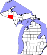
Iron County, Michigan Basics:


Iron County Michigan - Government Site

Population: 11,571
Area: 1166 square miles
County seat: Crystal Falls
Area code(s) in use: 906
Time zone: CST
High school graduate or higher: 89.3%
Bachelor's degree or higher: 17.7%
Median household income: $35,551
Persons in poverty: 13.7%
Home ownership rate: 84.7%
Mean travel time to work: 18.2 minutes


Adjacent counties:
Baraga  Dickinson  Florence (WI)  Forest (WI)  Gogebic  Houghton  Marquette  Ontonagon  Vilas (WI)  

Find in Michigan

Map of the Iron County area


Our detail map of Iron County shows the Iron County, Michigan boundary lines and other interesting items.

Places in Iron County, Michigan

  Airports     show all on map

Huber Airport, Iron County Airport, Stambaugh Airport

  Buildings     show all on map

Alpha - Mastodon Township Volunteer Fire Department Station 1 Headquarters, Alpha - Mastodon Township Volunteer Fire Department Station 2, Alpha Village Hall, Amasa - Hematite Township Volunteer Fire Department, Amasa Community Library, Amasa Museum, Bates Township Hall, Caspian Police Department, Caspian Volunteer Fire Department / Gaastra Volunteer Fire Department, Crystal Falls Fire Department, Crystal Falls Library, Crystal Falls Police Department, Gaastra Police Station, Greater Iron County Emergency Medical Services Station 2, Harbour House Museum, Iron County Courthouse, Iron County Historical Museum, Iron County Ice Arena, Iron County Sheriff's Office, Iron River City Hall, Iron River Police Department, Michigan Department of Natural Resources Crystal Falls Field Office, Michigan State Police Department, Raymond Gustafson Archive Library, West Iron County Fire Department, West Iron District Library

  Canals     show all on map

Little Bull Diversion Canal

  Capes     show all on map

Hotel Point

  Cemeteries     show all on map

Bates Cemetery, Crystal Falls City Cemetery, Hematite Cemetery, Indian Burial Ground, Iron River Cemetery, Resthaven Cemetery, Rosehill Cemetery, Stambaugh Cemetery, Stambaugh Cemetery

  Census     show all on map

Amasa Census Designated Place

  Churches     show all on map

Beechwood Church, Bethany Church, Bethany Lutheran Church, Christ United Methodist Church, Community Church of Nazarene, Faith Baptist Church, Finnish Lutheran Church, First Assembly of God Church, First Baptist Church, First Lutheran Church, First Presbyterian Church, Grace Covenant Church, Grace United Methodist Church, Guardian Angels Church, Iron River Bible Church, Iron River Jehovah's Witnesses, Iron River Seventh-Day Adventist Church, Lakeland Baptist Church, Lakeview Bible Church, Saint Agnes Catholic Church, Saint Cecilia Church, Saint John's Episcopal Church, Saint Mark's Episcopal Church, Saint Paul's Lutheran Church, Saint Peters Lutheran Church, Sion Lutheran Church, Trinity Lutheran Church, United Lutheran Church, Wesley United Methodist Church

  Dams     show all on map

Bear Trap Dam, Brule Island Dam, Gagnon Dam, Hemlock Falls Dam, Holmes Dam, Lower Paint Dam, Michigamme Falls Dam, Peavy Falls Dam, Premo Dam, Spaulding Dam, Way Dam

  Falls     show all on map

Chicagon Falls, Chipmunk Falls, Dumpy Falls, Glidden Rapids, Margeson Falls, Michigamme Falls (historical), Middle East Jumbo River Falls, Upper East Tumbo River Falls

  Forests     show all on map

Iron Range State Forest

  Hospitals     show all on map

Crystal Falls Family Health Center, Crystal Manor Nursing Home, Falls Clinic, Iron County Community Hospital, Iron County Community Hospital, Iron County Medical Care Facility, Iron River Care Center, Marquette Medical Clinic

  Islands     show all on map

Scaddens Island

  Lakes     show all on map

Anderson Lake, Arc Lake, Archie Pond, Armstrong Lake, Arrow Lake, Avaunt Pond, Balcomb Lake, Barrett Lake, Bass Lake, Basswood Pond, Bates Lake, Bates Lake, Bearpaw Lake, Beaver Lake, Beaver Lake, Bela Lake, Bennan Lake, Bennett Lake, Big Spring Hole, Blue Lake, Bone Lake, Bonny Lake, Branch Line Lake, Brule Lake, Buck Lake, Buck Lake, Buddle Lake, Bullhead Lake, Butler Lake, Cable Lake, Camp Lake, Camp Lake, Cemetery Lake, Chamberlain Lake, Chara Lake, Chicagon Lake, Chicken Lake, Chief Edwards Lake, Chuck Lake, Circle Lake, Clear Lake, Club Lake, Cone Lake, Corbett Lake, Cottenham Lake, Cougar Lake, Cranberry Lake, Crane Lake, Crotch Lake, Crowfoot Lake, Curry Lake, Dahm Lake, Dam Lake, Dawson Lake, Dead Mans Lake, Deer Lake, Diana Pond, Dishaw Lake, Doe Lake, Dog Lake, Dragon Pond, Dry Lake, Dunn Lake, East Paint Lake, Ebony Lake, Elinor Lake, Elk Lake, Emerson Lake, Erickson Lake, Ermine Lake, Feeder Lake, Fern Lake, Finn Lake, Fire Lake, First Lake, Fisher Lake, Forest Lake, Fortune Lakes, Forty Nine Pond, Fourth Lake, Fox Farm Lake, Frog Pond, Fur Farm Pond, Gabbit Lake, Gadwall Lake, Gages Lake, Galpin Lake, Gasley Lake, Gibson Lake, Gilbert Lake, Glare Lake, Glidden Lake, Glitter Lake, Golden Lake, Gravel Pit Lake, Greig Lake, Grosse Lake, Hagerman Lake, Hammer Lake, Hannah Webb Lake, Harding Lake, Hardwood Lake, Hehe Lake, Hemlock Lake, Herbs Lake, Hickman Lake, Holmes Lake, Holmes Lake, Homan Lake, Hope Lake, Horn Lake, Horseshoe Lake, Houser Lake, Ice Lake, Indian Lake, Iron Lake, Isaacson Lake, James Lake, Jingle Lake, Johnson Lake, Jule Lake, Kennedy Lake, Ketchum Lake, Killdeer Lake, Knave Lake, LaCrosse Lake, Lake Ellen, Lake Emily, Lake Fifteen, Lake IHM, Lake Mary, Lake Mitigwaki, Lake Nine, Lake Ottawa, Lake Sainte Kathryn, Lake Sixteen, Lake Thirty Two, Lake Twentytwo, Lake Wallace, Laurel Lake, Leather Leaf Lake, Lewis Lake, Light Lake, Little Hagerman Lake, Little Lake Ellen, Little Mud Lake, Little Nesbit Lake, Little Pickerel Lake, Little Smoky Lake, Little Spring Lake, Little Sundog Lake, Little Tamarack Lake, Little Tobin Lake, Little Wolf Lake, Liver Lake, Long Lake, Long Lake, Lost Lake, Lost Lake, Lower Holmes Lake, Lower Holmes Lake, Madelyn Lake, Maggie Lakes, Mallard Lake, Mallard Lake, Marsh Lake, Marten Lake, McPherson Lake, Merrick Lake, Merriman Lake, Minnie Lake, Mitchell Lake, Moccasin Lake, Moose Lake, Morrison Lake, Mud Lake, Mud Lake, Mud Lake, Mud Lake, Mud Lake, Mud Lake, Mud Lakes, Muffle Lake, Murphy Lake, Muskrat Lake, Nelson Lake, Nesbit Lake, North Deerskin Lake, Norway Lake, Otter Lake, Paint Lake, Paint River Pond, Papoose Lake, Pathic Lake, Paw Lake, Perch Lake, Petrow Lake, Pin Lake, Plover Lake, Poker Lake, Polliwog Lake, Ponozzo Lake, Poplar Ridge Lake, Porcupine Lake, Porcupine Lake, Porter Lake, Premo Lake, Quiver Lake, Rabbitz Lake, Railroad Lake, Ripple Lake, Robinson Lake, Rock Lake, Rookery Lake, Roost Lake, Runkle Lake, Scott Lake, Second Lake, Seven Springs Lake, Shank Lake, Shiner Lake, Shoe Pac Lake, Silk Lake, Silver Lake, Skyline Lake, Smoky Lake, Snipe Lake, Snow Lake, Spies Lake, Spot Lake, Spot Lake, Spree Lake, Spring Lake, Spring Lake, Square Lake, Squaw Lake, Stager Lake, Stanley Lake, Sullivan Lake, Sunset Lake, Swamp Lake, Swan Lake, Syrup Lake, Tepee Lake, Third Lake, Tim Bowers Pond, Timber Lake, Tinsel Lake, Toots Lake, Trap Lake, Twin Lakes, Upper Holmes Lake, Upper Holmes Lake, Violet Lake, Wagner Lake, Webb Lake, Whisper Lake, Wide Waters, Wildcat Lake, Wildwood Lake, Winslow Lake, Wolf Lake

  Locales     show all on map

Alpha Station (historical), Amasa Station, Balsam Station, Basswood Station (historical), Beechwood Station (historical), Black House Campground, Brule Mountain Ski Area, Camp Gibbs, Camp Gibbs Recreation Area, Casagranda Race Track, Caspian Station (historical), Crystal Falls Station (historical), Crystal View Golf Course, Deer Lake State Forest Campground, Dishaws Camp, Dunn Station (historical), Elmwood Station (historical), Fortune Lake Lutheran Camp, George Young Golf Course, Glidden Lake State Forest Campground, Golden Lake Recreation Area, Hagerman Lake Recreation Area, Hazel Station (historical), Holmes Park, Iron County Fairgrounds, Iron River Country Club, Iron River RV Park, Iron River Station (historical), Kelso Junction, Lake Ellen Campground, Lake Ottawa Recreation Area, Lake Sainte Kathryn Campground, McMillan Camp, Mitchell Spur, Nesbit Lake Organization Camp, Norway Lake Campground and Picnic Area, Old Atkinson Dam Site, Paint Dam, Paint River Forks Campground, Paint River Hills Campground, Panola Station (historical), Parks Siding, Pentoga Station (historical), Perch Lake Campground, Scott Lake Station (historical), Stager Station (historical), Stambaugh Station (historical), State Line Recreation Area, Tepee Lake Campground and Picnic Area, Triangle Ranch, University of Michigan Forestry Camp, Wild River Motel and RV Park

  Mines     show all on map

Bates Mine, Bengal Mine, Book Mine, Cardiff Mine, Davidson Number Three Mine, Dober Number 2 Mine, Forbes Mine, Hiawatha Number One Mine, Hiawatha Number Two Mine, Homer Mine, James Mine, Minckler Mine, Monongahela Mine, Porter Mine, Rogers Mine, Shafer Mine, Sherwood Mine, Spies Mine, Warner Mine, Wauseca Mine

  Parks     show all on map

Bachman Park, Bewabic Park, Dawson Lake Park, Elmwood Wayside, First Roadside Park Historical Marker, Gibson Lake Park, Hoover Park, Ice Lake Park, Indian Village Historical Marker, Iron County Forest Preserve, Iron County Historical Marker, Iron Inn Historical Marker, Lincoln Park, MacKinnon House Historical Marker (historical), Mattol Park, Me-Squa-L-Cum-E Park, Nanaimo Park, Nelson Field, Pentoga Park, Runkle Lake Park, Stager Lake Park, Sunset Lake Park

  Populated Places     show all on map

Alpha, Amasa, Balsam, Basswood, Bates Junction, Bates Location, Beechwood, Caspian, Chicagon, Crystal Falls, Dunn Location, Elmwood, Erickson Landing, Forbes Location, Fortune Lake, Gaastra, Gibbs City, Gibson Lake, Hazel, Hiawatha Location, Homer Location, Iron River, Kelso Junction, Kiernan, Kimball Location, Mansfield, Mansfield Location, Mapleton, Mastodon, Mineral Hills, Monongahela Location, Naults, New Bristol Location, Odgers Location, Palatka, Panola, Pentoga, Rogers Location, Scott Lake, Shafer Location, Stager, Stambaugh, Tobin Location, Virgil Location, Western Location

  Post Offices     show all on map

Alpha Post Office, Amasa Post Office, Balsam Post Office (historical), Beechwood Post Office (historical), Caspian Post Office, Clinch Post Office (historical), Crystal Falls Post Office, Dunn Post Office (historical), Gaastra Post Office, Gibbs City Post Office (historical), Iron River Post Office, Mansfield Post Office (historical), Mapleton Post Office (historical), Mastodon Mine Post Office (historical), Maywood Post Office (historical), Maywood Post Office (historical), Net River Post Office (historical), Paintriver Post Office (historical), Pentoga Post Office (historical), Saunders Post Office (historical), Stambaugh Post Office

  Rapidss     show all on map

Hemlock Rapids, Horserace Rapids, Little Bull Rapids, Lower Hemlock Rapids, Snake Rapids

  Reservoirs     show all on map

Camp Eight Ponds, McCutcheon Lake, Michigamme Lake, Michigamme Reservoir, Peavy Pond

  Schools     show all on map

Ace High School, Bates School, Forest Park High School, Iron County Community School, Stambaugh Elementary School, West Iron County High School, West Iron Middle School

  Springs     show all on map

Passmore Springs

  Streams     show all on map

Alpha Creek, Antoine Creek, Armstrong Creek, Autio Creek, Barnetts Creek, Bass Creek, Beaver Creek, Bela Creek, Blaney Creek, Bleat Creek, Borski Creek, Briar Hill Creek, Brule River, Bush Creek, Cable Lake Creek, Camp Creek, Camp Creek, Camp Eight Creek, Camp Five Creek, Camp Lake Creek, Camp Six Creek, Cedar Creek, Chicagon Slough, Clarks Creek, Cooks Run, Costigan Creek, Crystal Spring Creek, Davison Creek, De Mongo Creek, Dead Slough, Dead Stream, Deer River, Defiance Creek, Dunn Creek, East Branch Armstrong Creek, East Branch Fence River, East Branch Hemlock River, East Branch Net River, East Fork Premo Creek, Edna Creek, Ermine Creek, Farley Creek, Fence River, Finn Farm Creek, Fire Lake Creek, First Creek, Flanigan Creek, Fortune Lake Creek, Fourth Creek, Fribley Creek, Gages Creek, Gilbert Creek, Glitter Creek, Golden Creek, Gravel Pit Creek, Hagerman Creek, Harrison Creek, Hemlock River, Hickman Creek, Holmes Creek, Holmes Creek, Iron Lake Creek, Iron River, Jake Creek, Jesso Creek, Johnson Creek, Jones Camp Creek, Jumbo River, Jungle Creek, Kelso Creek, Kelso River, Ketchum Creek, Kidney Creek, Knave Creek, Kukura Creek, La Fournier Creek, Lambert Creek, Larson Creek, Leonard Creek, Little Hemlock River, Lode Creek, Longs Creek, Mallard Creek, Manila Creek, Margeson Creek, Marten Creek, Mastodon Creek, McAllister Creek, McColman Creek, McCutcheon Creek, McGoverns Creek, McMillan Creek, McRae Creek, Michigamme River, Michigamme Slough, Mikes Creek, Mitchigan River, Mitigwaki Creek, Morrison Creek, Nash Creek, Nelson Creek, Net River, New York Creek, Nolenchec Creek, North Branch Iron River, North Branch Paint River, Noyes Creek, Old Joe Creek, Olson Creek, Olson Creek, Paint Creek, Paint River, Parks Creek, Parks Creek, Pass Creek, Passmore Creek, Pendleton Creek, Peterson Creek, Pickerel Lake Creek, Porter Creek, Post Creek, Premo Creek, Preston Creek, Railroad Creek, Reservoir Creek, Saint Paul Creek, Seven Springs Creek, Seventeen Creek, Shank Lake Creek, Shenky Creek, Silver Creek, Slate Creek, Smith Creek, South Branch Iron River, South Branch Paint River, South Slough, Spring Lake Creek, Stager Creek, Stanley Creek, Start Creek, Stony Creek, Stump Creek, Sunset Creek, Tepee Creek, Thirtythree Creek, Threemile Creek, Tim Bowers Creek, Tote Creek, Twenty Six Creek, Wagner Creek, Waterworks Creek, West Branch Armstrong Creek, West Branch Fence River, West Branch Hemlock River, West Branch McCutcheon Creek, West Branch Mitchigan River, West Branch Net River, Wildman Creek, Wilson Creek, Winslow Creek, Wolf Creek, Youngers Creek

  Summits     show all on map

Michigamme Mountain, Sheridan Hill

  Swamps     show all on map

Triangle Spur

  Towers     show all on map

Bates Fire Tower, Brule Lookout Tower, Gibbs Lookout, Golden Lake Lookout Tower, Mallard Lake Lookout Tower, Perch Lake Lookout Tower, Tepee Lookout Tower, WIKB-AM (Iron River), WIKB-FM (Iron River), WIMI-FM (Ironwood), WJMS-AM (Ironwood)

  Trails     show all on map

Big Bear Ski Trail, Double Doodle Ski Trail, Homestead Ski Trail, Hot Cider Ski Trail, Log Jam Ski Trail, Maple Syrup Ski Trail, North Forty Ski Trail, Otterslide Ski Trail, Snow Shoe Ski Trail, Spillway Ski Trail, Sunrise Ski Trail, The Rapids Ski Trail, Timberdoodle Ski Trail, Whitewater Ski Trail,

Iron County, Michigan Population By Race (2012 estimate)

RacePopulation
WhiteIron County White population 11,22411,223  
MixedIron County Mixed population 150150
American IndianIron County American Indian population 139138
AsianIron County Asian population 3534
BlackIron County Black population 2323
Hawaiian & Pacific IslanderIron County Hawaiian & Pacific Islander population 00

Additional population tables :
State population table
Michigan population by county