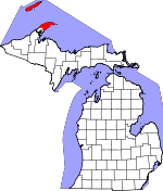
Keweenaw County, Michigan Basics:


Keweenaw County Michigan - Government Site

Population: 2,211
Area: 540 square miles
County seat: Eagle River
Area code(s) in use: 906
Time zone: EST
High school graduate or higher: 91.4%
Bachelor's degree or higher: 23.6%
Median household income: $42,406
Persons in poverty: 18.8%
Home ownership rate: 87.3%
Mean travel time to work: 20.7 minutes


Adjacent counties:
Houghton  

Find in Michigan

Map of the Keweenaw County area


Our detail map of Keweenaw County shows the Keweenaw County, Michigan boundary lines and other interesting items.

Places in Keweenaw County, Michigan

  Arches     show all on map

Amygdaloid Arch, Caribou Arch

  Bars     show all on map

Brandsford Reef, Butterfield Shoal, Canoe Rocks, Congdon Shoal, Cumberland Reef, Dead Horse Rocks, Doden Reef, Domen Reef, Eagle River Shoals, Finlander Reef, Five Foot Reef, Glenlyon Shoal, Gull Rock, Gull Rocks, Harlem Reef, Hutchinson Shoal, Inner Reef, McCormick Reef, McCormick Rocks, Middle Ground Reef, San Antonio Reef, South Rock, Taylor Reef, West Lump Reef

  Basins     show all on map

Moskey Basin

  Bays     show all on map

Agate Harbor, Belle Harbor, Bete Grise Bay, Betsy Bay, Big Bay, Blueberry Cove, Brady Cove, Cat Harbor, Chippewa Harbor, Conglomerate Bay, Copper Harbor, Crystal Cove, Dollar Bay, Duncan Bay, Eagle Harbor, Fish Cove, Fishermans Bay, Fishermans Home Cove, Five Finger Bay, Florence Bay, Gilberts Hole, Grace Harbor, Grand Marais Harbor, Great Sand Bay, Hay Bay, Herring Bay, High Rock Bay, Hopkins Harbor, Horseshoe Harbor, Huginnin Cove, Keystone Bay, Kjaringa Kjeft, Lane Cove, Lea Cove, Little Boat Harbor, Little Todd Harbor, Malone Bay, McCargoe Cove, McGinty Cove, North Bay, North Bay, Oliver Bay, Pickerel Cove, Pickett Bay, Rainbow Cove, Robinson Bay, Rock Harbor, Siskiwit Bay, Snug Harbor, South Bay, South Bay, Square Bay, Stockly Bay, Sucker Bay, Tobin Harbor, Todd Cove, Todd Harbor, Tonkin Bay, Vodrey Harbor, Washington Harbor

  Beaches     show all on map

Agate Beach, Attwood Beach, Carnelian Beach, Greenstone Beach, Little Greenstone Beach, Thomsonite Beach

  Buildings     show all on map

Ahmeek Fire Department, Ahmeek Townhall, Allouez Township Community Center, Allouez Township Fire Department, Allouez Township Hall, Copper Harbor Fire Department, Eagle Harbor Township Volunteer Fire Department Station 1 Headquarters, Eagle Harbor Township Volunteer Fire Department Station 2, Grant Township Town Hall, Keweenaw County Sheriff's Office, Lac La Belle Volunteer Fire Department, Sherman Township Fire Department

  Canals     show all on map

Mendota Canal

  Capes     show all on map

Agate Point, Baker Point, Black Rock Point, Blake Point, Butterfield Point, Card Point, Checker Point, Crow Point, Cumberland Point, Dans Point, Fadner Point, Finn Point, Five Mile Point, Francis Point, Grass Point, Hill Point, Indian Head Point, Indian Point, Kamloops Point, Keweenaw Point, Keystone Point, Locke Point, Long Point, Middle Point, Mine Point, Moose Point, Point Hay, Point Houghton, Point Isabelle, Rainbow Point, Red Rock Point, Saginaw Point, Scoville Point, Senter Point, Sevenmile Point, Spruce Point, Starvation Point, The Head, Twelve O'Clock Point, Wilson Point

  Cemeteries     show all on map

Ahmeek Cemetery, Cemetery Island Cemetery, Cliff Catholic Cemetery, Copper Harbor Cemetery, Eagle River Cemetery, Fort Wilkins State Park Cemetery, Hillside Cemetery, Isle Royale Cemetery, Pine Grove Cemetery

  Census     show all on map

Copper Harbor Census Designated Place, Eagle Harbor Census Designated Place, Eagle River Census Designated Place

  Channels     show all on map

Amygdaloid Channel, Bryersund, Houghton Point Passage, Lorelei Lane, Merritt Lane, Middle Islands Passage, North Gap, Smithwick Channel, The Keyhole, The Narrows

  Churches     show all on map

Bethany Lutheran Church, Fulton Apostolic Lutheran Church

  Cliffs     show all on map

The Palisades, West Bluff

  Falls     show all on map

Copper Falls, Eagle River Falls, Haven Falls, Jacobs Falls, Lower Falls, Lower Falls, Manganese Falls, Silver River Falls, Siskiwit Falls, Upper Falls, Upper Falls

  Flats     show all on map

Montreal Meadows

  Harbors     show all on map

Dog Harbor

  Islands     show all on map

Amygdaloid Island, Annie Island, Arch Island, Bailey Island, Barnum Island, Bat Island, Battleship Island, Beaver Island, Belle Isle, Birch Island, Birch Isle, Bobs Island, Booth Island, Bottle Island, Boys Island, Burnt Island, Burnt Island, Captain Kidd Island, Castle Island, Cemetery Island, Center Island, Channel Island, Chippers Island, Clay Island, Cork Island, Davidson Island, Dean Island, Diamond Island, Dog Island, Eagle Island, Eagle Nest Island, East Caribou Island, Edwards Island, Elizabeth Island, Emerson Island, Fire Island, Fisher Island, Flag Island, Fryett Island, Gale Island, Glenns Island, Grace Island, Green Island, Green Isle, Gull Islands, Hastings Island, Hat Island, Hawk Island, Heron Island, Hog Island, Horn Island, Horner Island, Howe Island, Inner Hill Island, Inner Island, Isle Royale, Johns Island, Johnson Island, Kamloops Island, Little Siskiwit Island, Lone Tree Island, Long Island, Long Island, Lucky Island, Mad Island, Malone Island, Manitou Island, Menagerie Island, Merritt Island, Middle Islands, Minong Island, Mott Island, Net Island, Newman Island, North Government Island, North Rock, Ollies Dogs Rocks, Outer Hill Island, Outer Island, Park Place Island, Passage Island, Paul Islands, Pete Island, Picnic Island, Porter Island, Porters Island, Rabbit Island, Raspberry Island, Redfin Island, Ross Island, Round Island, Ryan Island, Salt Island, Savage Island, Schooner Island, Shaw Island, Shiverette Island, Siskiwit Islands, Smith Island, Smithwick Island, South Government Island, Split Island, Star Island, Steamboat Island, Stone House Island, Tallman Island, Taylor Island, Teakettle Island, Third Island, Thompson Island, Tookers Island, Washington Island, West Caribou Island, Wheelock Island, Wilson Island, Wright Island

  Lakes     show all on map

Amygdaloid Lake, Angleworm Lake, Bailey Pond, Bay Lake, Beaver Lake, Beaver Pond, Breakfast Lake, Central Lake, Chickenbone Lake, Clear Lake, Copper Falls Lake, Copper Lake, Deer Lake, Deerwater Lake, Eliza Lake, Epidote Lake, Feldtmann Lake, Forbes Lake, Gill Lake, Gull Lake, Hatchet Lake, Hidden Lake, Hoar Lake, Horseshoe Pond, Intermediate Lake, Lac La Belle, Lake Addie, Lake Ahmik, Lake Bailey, Lake Benson, Lake Desor, Lake Dustin, Lake Eva, Lake Fanny Hooe, Lake George, Lake Glazon, Lake Gratiot, Lake Halloran, Lake Harvey, Lake John, Lake Livermore, Lake Manganese, Lake Mason, Lake Medora, Lake Ojibway, Lake Richie, Lake Scholts, Lake Shesheeb, Lake Theresa, Lake Upson, Lake Wagejo, Lake Whittlesey, LeSage Lake, Lily Lake, Lily Lake, Linklater Lake, Long Lake, Lost Lake, McDonald Lake, Meadow Lake, Meadow Lake, Meadow Lake, Moose Lake, Mud Lake, Mud Lake, Mud Lake, Mudd Lake, Newt Lake, North Pond, Otter Lake, Owl Lake, Partridge Lake, Patterson Lake, Patterson Lake, Perch Lake, Sargent Lake, Schlatter Lake, Seneca Lake, Siskiwit Lake, Stickleback Lake, Sumner Lake, Thayer Lake, Turtle Lake, Wallace Lake, Wood Lake

  Locales     show all on map

Ahmeek Station (historical), Allouez Station (historical), Beaver Island Campground, Belle Isle Campground, Birch Island Campground, Boreal Research Station, Caribou Island Campground, Chippewa Harbor Campground, Copper Harbor Lighthouse, Copper Harbor Marine, Copper Harbor Rear Range Lighthouse, Daisy Farm Campground, Duncan Bay Campground, Duncan Bay Narrows Campground, Eagle Harbor Lighthouse, Eagle Harbor Marina, Eagle River Lighthouse (historical), East Chickenbone Lake Campground, Feldtmann Lake Campground, Fulton Station (historical), Gay Station (historical), Grace Island Campground, Gull Rock Light, Hatchet Lake Campground, Hay Bay Campground, Hebard Station (historical), Huginnin Cove Campground, Isle Royale Lighthouse, Keweenaw Mountain Lodge Golf Course, Lac La Belle Marina, Lac La Belle Resort, Lake Desor Campground (historical), Lake Fanny Hooe Resort and Campground, Lake Richie Campground, Lane Cove Campground, Little Todd Campground, Lookout Louise, Malone Bay Campground, Mandan Station (historical), Manitou Island Lighthouse, McCargoe Cove Campground, Mendota Light House, Merritt Lane Campground, Moskey Basin Campground, Mount Bohemia Ski Area, North Lake Desor Campground, North Piech Lighthouse, Ojibway Station (historical), Old Fort Wilkins, Passage Island Lighthouse, Passage Island Lighthouse, Phoenix Station (historical), Rock Harbor Lighthouse, Rock of Ages Lighthouse, Sand Hills Lighthouse, Siskiwit Bay Campground, South Lake Desor Campground, Tamarack Waterworks, Threemile Campground, Tobin-Rock Harbor Campground, Todd Harbor Campground, Tookers Island Campground, Washington Creek Campground, West Chickenbone Lake Campground

  Military     show all on map

Calumet Air Force Station (historical)

  Mines     show all on map

Ahmeek Mine, Datolite Mine, Epidote Mine, Gratiot Mine, Haytown Mine, Island Mine, Lucky Bay Mine, Minong Mine, Ransom Mine, Saginaw Mine, Siskowit Mine, Smithwick Mine, Wendigo Mines

  Parks     show all on map

Daybeacon Stoll Memorial, Eagle Harbor House Historical Marker, Eagle River Historical Marker, Esrey Park, Fort Wilkins Historical Marker (historical), Fort Wilkins State Park, Haven Park, Hebard Park, Isle Royale National Park, Keweenaw County Park, Lake Shore Drive Bridge Historical Marker

  Pillars     show all on map

Gull Rock, Monument Rock

  Populated Places     show all on map

Ahmeek, Allouez, Bete Grise, Betsy, Bumbletown, Central, Copper Falls, Copper Harbor, Delaware, Eagle Harbor, Eagle Nest, Eagle River, Fulton, Gay, Hebards, Lac La Belle, Mandan, Mohawk, Nepco Camp Number 7, Ojibway, Phoenix, Rock Harbor Lodge, Seneca, Snowshoe, Traverse, Vaughnsville, Windigo, Wyoming

  Post Offices     show all on map

Ahmeek Post Office, Allouez Post Office (historical), Belle Harbor Post Office (historical), Belle Harbor Post Office (historical), Central Mine Post Office (historical), Clifton Post Office (historical), Cooper Harbor Post Offcie (historical), Copper Harbor Post Office, Delaware Mine Post Office (historical), Eagle Harbor Post Office (historical), Eagle Harbor Post Office (historical), Eagle River Post Office, Gay Post Office (historical), Hebard Post Office (historical), Island Mine Post Office (historical), Isle Royale Natinal Park Post Office (historical), Johns Post Office (historical), Johns Post Office (historical), Mandan Post Office (historical), Minong Post Office (historical), Mohawk Post Office, Ojibway Post Office (historical), Phoenix Post Office (historical), Rock Harbor Post Office (historical), Singerville Post Office (historical), Singerville Post Office (historical), Tobins Harbor Post Office (historical), Tobins Harbor Post Office (historical)

  Reserves     show all on map

Isle Royale Wilderness

  Ridges     show all on map

Cliff Range, Coyote Ridge, East Bluff, Feldtmann Ridge, Greenstone Ridge, Houghton Ridge, Minong Ridge, Red Oak Ridge, Rocky Ridge, Stanley Ridge

  Schools     show all on map

Betsy River School, Copper Harbor School, Horizons School, Lake Shore School

  Streams     show all on map

Aetna Creek, Bailey Creek, Benson Creek, Big Betsy River, Big Siskiwit River, Black Creek, Black Creek, Brewery Creek, Bruneau Creek, Buffalo Creek, Camp Creek, Caribou Creek, Cedar Creek, Copper Creek, Eagle River, East Branch Eagle River, Eister Creek, Eliza Creek, Farlow Creek, Finey Creek, Finns Creek, French Annie Creek, Fulton Creek, Garden Brook, Garden City Creek, Grace Creek, Gratiot River, Haven Creek, Hills Creek, Hoar Creek, Jacobs Creek, Little Betsy River, Little Gratiot River, Little Siskiwit River, Medora River, Montreal River, Mud Creek, Nine Thirty Two Creek, Owl Creek, Silver Creek, Silver River, Siskiwit River, Snake Creek, Sucker Creek, Tobacco River, Tobin Creek, Traverse River, Union Creek, Upson Creek, Vulcan Creek, Washington Creek, West Branch Eagle River, Winters Creek

  Summits     show all on map

Brockway Nose, Gratiot Mountain, Ishpeming Point, Mount Bohemia, Mount Desor, Mount Franklin, Mount Horace Greeley, Mount Houghton, Mount Lookout, Mount Ojibway, Mount Saginaw, Mount Siskiwit, Pine Mountain, Pine Mountain, Ransom Hill, Sugar Mountain

  Swamps     show all on map

Cedar Swamp, Madison Gap, The Marshes

  Towers     show all on map

Feldtmann Lookout Tower

  Trails     show all on map

Daisy Farm Trail, East Feldtmann Trail, East Huginnin Cove Trail, Feldtmann Lake Trail, Feldtmann Ridge Trail, Greenstone Ridge Trail, Hatchett Lake Trail, Huginnin Cove Trail, Indian Portage Trail, Ishpeming Trail, Island Mine Trail, Lake Richie Trail, Lane Cove Trail, Minong Ridge Fire Manway, Minong Ridge Fire Manway, Minong Ridge Trail, Mount Franklin Trail, Mount Ojibway Trail, Rainbow Cove Trail, Rock Harbor Trail, Stoll Trail, Tobin Harbor Trail, West Huginnin Cove Trail,

Keweenaw County, Michigan Population By Race (2012 estimate)

RacePopulation
WhiteKeweenaw County White population 2,1782,177  
MixedKeweenaw County Mixed population 2726
BlackKeweenaw County Black population 44
American IndianKeweenaw County American Indian population 22
Hawaiian & Pacific IslanderKeweenaw County Hawaiian & Pacific Islander population 00

Additional population tables :
State population table
Michigan population by county