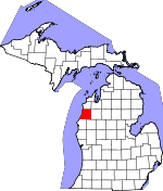
Manistee County, Michigan Basics:


Manistee County Michigan - Government Site

Population: 24,618
Area: 542 square miles
County seat: Manistee
Area code(s) in use: 231
Time zone: EST
High school graduate or higher: 87.9%
Bachelor's degree or higher: 17.7%
Median household income: $41,228
Persons in poverty: 15.3%
Home ownership rate: 79.4%
Mean travel time to work: 19.7 minutes


Adjacent counties:
Benzie  Grand Traverse  Lake  Mason  Wexford  

Find in Michigan

Map of the Manistee County area


Our detail map of Manistee County shows the Manistee County, Michigan boundary lines and other interesting items.

Places in Manistee County, Michigan

  Airports     show all on map

Horaks Airport, Manistee County-Blacker Airport

  Bridges     show all on map

Bonds Bridge, Christy Bridge, Cooley Bridge, High Bridge, Jopp Bridge, Ninemile Bridge, Potter Bridge, Red Bridge, Sixmile Bridge

  Buildings     show all on map

Arcadia Library, Arcadia Township Volunteer Fire Department, Bear Lake Library of Manistee, Bear Lake Township Fire Department, Bear Lake Township Hall, Brown Township Hall, Cleon Township Hall, Copemish - Cleon Township Fire Department, Dickson Township Fire Department, Dickson Township Hall, Eastlake Fire Department, Filer Township Fire Department, Filer Township Hall, Kaleva Depot Museum, Kaleva Library, Manistee City Fire Department, Manistee City Hall, Manistee Count Blacker Airport Fire Department, Manistee County Courthouse, Manistee County Library, Manistee County Museum, Manistee County Sheriff's Office, Manistee Police Department, Manistee Township Fire Department, Maple Grove Township Fire Department, Marilla Township Hall, Norman Township Fire Department, Oaks Correctional Facility, Onekama Public Library, Onekama Township Fire Department, Our Savior's Historical Museum, Pleasanton Township Hall, Ramsdell Theatre Opera House, Stronach Township Fire Department, United States Forest Service Manistee Ranger Station, Wellston County Library, West Shore Emergency Medical Services House 2

  Capes     show all on map

Eagle Point, Lookout Point, North Point, Portage Point

  Cemeteries     show all on map

Bear Lake Cemetery, Brethren Cemetery, Browntown Cemetery, Chalker Cemetery, Cleon Township Cemetery, Conway Cemetery, Dickson Cemetery, Dublin Cemetery, Fairview Cemetery, Harlan Cemetery, Lakeview Cemetery, Maple Grove Township Cemetery, Marilla Cemetery, Miller Cemetery, Mount Carmel Cemetery, Norwalk Lutheran Cemetery, Oak Grove Cemetery, Old Schoolhouse Cemetery, Old Stronach Cemetery, Onekama Cemetery, Onekama Cemetery, Pilgrim Home Cemetery, Pleasantview Cemetery, Pleasonton Township Cemetery, Riverview Cemetery, Saint Joseph Cemetery, Springdale Cemetery, Trinity Cemetery, Wellston Cemetery

  Census     show all on map

Arcadia Census Designated Place, Brethren Census Designated Place, Filer City Census Designated Place, Oak Hill Census Designated Place, Parkdale Census Designated Place, Stronach Census Designated Place, Wellston Census Designated Place

  Churches     show all on map

Bear Lake Methodist Church, Bethany Lutheran Church, Church of Christ, Church of Jesus Christ of Latter Day Saints, Church of the Brethren, Danish Church, Epworth United Methodist Church, Faith Covenant Church, First Baptist Church, First Church of Wellston, First Congregational Church, First Congregational Church, Good Shepherd Lutheran Church, Guardian Angels Church, Heritage Church, Holy Trinity Episcopal Church, Jehovah's Witnesses, Kaleva Baptist Church, Kingdom Hall, Manistee Assembly of God Church, Manistee United Methodist Church, Marilla Church, New Life Tabernacle Church, Norwalk Church, Onekama Church of the Brethren, Pleasantview Church, Pomona Bible Church, Saint John-Lake Episcopal Church, Saint Joseph Catholic Church, Saint Joseph Church, Saint Marys Mount Carmel Church, Saint Paul's Lutheran Church, Saint Raphael Church, Seventh Day Adventist Church, Springdale Church, Trinity Lutheran Church, Trinity Lutheran Church, Trinity Lutheran Church

  Dams     show all on map

Stronach Dam

  Flats     show all on map

Flower Flats

  Guts     show all on map

Anderson Bayou, Borski Bayou, Browns Bayou, Deer Lake Bayou, Highpoint Bayou, Jenkins Bayou, Sergant Bayou

  Hospitals     show all on map

Crystal Lake Clinic, Kaleva and Wellston Medical Center, Little River Band Health Center, Manistee County Care Facility, Onekama Area Health Center, Wellston Medical Center, West Shore Medical Center

  Islands     show all on map

Birch Island, Cedar Island, Dam Island, Fitch Island, Government Island, Virgin Island

  Lakes     show all on map

Adamson Lake, Arcadia Lake, Ball Pond, Bar Lake, Bear Lake, Blacksmith Bayou, Browns Bayou, Canfield Lake, Center Lake, Chief Lake, Chittenden Lake, Clarence Lake, Claybank Lake, Cooper Lake, Cranberry Lake, Dickson Lake, Dorner Lake, Gambs Lake, Glovers Lake, Gordon Lake, Healy Lake, James Lake, King Lake, Krouse Lake, Lake Elinor, Lake Emma, Lake of the Woods, Lake Salma, Lake Winnogene, Lemon Lake, Lost Lake, Makinen Pond, Manistee Lake, Mud Lake, Mud Lake, Mud Lake, Pine Lake, Portage Lake, Shingle Mill Lake, Star Lake, Sylvan Pond, Timmerman Lake, Totches Bayou, Walton Pond, Watson Lake

  Locales     show all on map

Arcadia Bluffs Golf Club, Arcadia Marina Campground, Arcadia Station (historical), Bear Creek Public Access, Big Four Corners, Blacksmith Bayou Campground, Blacksmith Bayou Public Access, Borski School, Brethren Station (historical), Buitema Dock and Dredge Company, Butwell Station (historical), Century Boat Company, Chestnut Hills Golf Course, Chief Lake Station (historical), Clark Equipment Company, Claybank School, Coho Bend Campground, Copemish Station (historical), Country Highlands Golf Course, Crystal Forest Campground, Dublin Station (historical), Eastlake Station, Fawn Crest Golf Course, Filer City Station (historical), Fox Hills Golf Course, Fuzzy Bear Campground, Glenoak School, Glover's Lake Station (historical), Goodrich Station (historical), Hale Corners, Hardy Salt Company, Harlan Station (historical), Healy Lake Campground, Heart of the Forest RV Park, Heathlands Golf Course, Henry Station (historical), High Bridge Public Access, Hopkins Park Campground, Humphrey Station (historical), Inner Light, Insta Launch Campground, Kaleva Station (historical), Kenny School, Kilborn School, Lemon Lake Station (historical), Low Bridge Canoe Access, Malcolm Station (historical), Manikiwa Recreation Site, Manistee County Fairgrounds, Manistee Drop Forge Corporation, Manistee Golf and Country Club, Manistee National Forest District Ranger Station, Manistee National Golf and Resort, Manistee North Pierhead Lighthouse, Manistee Station, Manisteel Incorporated, Marila Trailhead, Marsh, Martin Marietta Chemicals, Matson's Big Manistee River Campground, Morton Chemical Company, Morton Salt Company, Myers School, Newland Station (historical), North Pierh Light, Northern Michigan Dragway, Oak Grove School, Old High Bridge R R Crossing Site, Old Stronach Public Access, Orchard Beach State Park Campground, Packaging Corporation of America, Parkdale Station, Pomona Station (historical), Portage Lake RV Park, Rainbow Bend Public Access, Red Bridge Public Access, Saile Station (historical), Sorenson Station (historical), South Pier Light, Star Corners, Stronach Station, Tanner Station (historical), Tannerville, Tippy Dam North Recreation Area, Tippy Dam Road Campgrounds, Twin Oaks Campground, Udell Rollways Recreation Area, Wellston Station (historical)

  Military     show all on map

Coast Guard Station Manistee

  Parks     show all on map

Arcadia Veterans Memorial, Battle House Historical Marker, Crystal Lake Township Park, Dickson Township Park, Dorner Lake Recreation Site, East Lake Village Park, First Congregational Church Historical Marker, First Street Beach, Great Fire of 1871 Historical Marker, Grebe Park, Harriet Quimby Childhood Home Historical Marker, Harriet Quimby Historical Marker, Holy Trinity Episcopal Church Historical Marker, Hopkins Park, Kaleva Historical Marker, Kaleva Roadside Park, Lewis Memorial Kids Park, Mangoon Creek Park, Manikawa Park, Manistee City Library Historical Marker, Manistee Fire Hall Historical Marker, Manistee River State Game Area, Mineral Springs Park, North Riverwalk and Memorial Park, Onekama Village Park, Orchard Beach State Park, Our Saviour's Lutheran Church Historical Marker, Pearl Park, Pickard Park, Ramsdell Theatre Historical Marker, Red Szymarek Park, Rietz Park, Sand Lake Recreation Area, Sands Park, Sundling Park, Trinity Lutheran Church Historical Marker, William Douglas House Historical Marker

  Populated Places     show all on map

Arcadia, Bar Lake, Bear Lake, Brethren, Chief Lake, Copemish, Douglas, Dublin, East Lake, Filer City, Humphrey, Kaleva, Kampvilla Mobile Home Park, Malcolm, Manistee, Marilla, Maue Corners, Newland, Norwalk, Oak Hill, Onekama, Onekama Junction, Parkdale, Pierport, Pleasanton, Pomona, Red Park, River Haven Mobile Home Park, Stronach, Udell, Wellston, Wic-a-te-wah, Williamsport

  Post Offices     show all on map

Arcadia Post Office, Bear Lake Post Office, Brethren Post Office, Copemish Post Office, Eastlake Post Office, Filer City Post Office, Harlan Post Office (historical), Henry Post Office (historical), High Bridge Post Office (historical), Humphrey Post Office (historical), Kaleva Post Office, Lemon Lake Post Office (historical), Malcolm Post Office (historical), Manistee Post Office, Marilla Post Office (historical), Norwalk Post Office (historical), Oakhill Post Office (historical), Onekama Post Office, Parkdale Post Office (historical), Pierport Post Office (historical), Pierport Post Office (historical), Pleasanton Post Office (historical), Pomona Post Office (historical), Portage Point Post Office (historical), Portage Point Post Office (historical), Stronach Post Office (historical), Tanner Post Office (historical), Wellston Post Office

  Reservoirs     show all on map

Crystal Lake, Tippy Dam, Tippy Dam Pond

  Schools     show all on map

Arcadia Elementary School, Ayres School, Bear Lake School, Brethren High School, Browntown School, Carpenter School, Central High School, Flynn School, Glover School, Guardian Angel School, Jefferson School, Kaleva-Norman-Dickson School, Kennedy School, Lincoln School, Madison School, Manistee High School, Manistee Middle School, Merritt School, Newland School, Onekama Consolidated Schools, Tomaszewski School, Trinity School, Washington School, Wellston Elementary School

  Springs     show all on map

Indian Springs

  Streams     show all on map

Arquilla Creek, Bear Creek, Bear Wallow Creek, Beaver Creek, Boswell Creek, Bowens Creek, Cedar Creek, Chamberlain Creek, Chicken Creek, Chief Creek, Claybank Bayou, Claybank Creek, Dead Creek, Dunham Creek, Dutchman Creek, Eddington Creek, First Creek, Greens Creek, Halls Creek, Hansen Creek, Hinton Creek, Horseshoe Creek, Hull Creek, Larson Creek, Lemon Creek, Little Bear Creek, Little Beaver Creek, Little Manistee River, Lucker Creek, Lumley Creek, Magoon Creek, Manistee River, McGowans Creek, Pine Creek, Pine River, Podunk Creek, Richley Creek, Sands Creek, Schimke Creek, Schimke Creek, Second Creek, Sickle Creek, Slagle Creek, Sylvan Creek, Tank Creek, Third Creek, Tondu Creek, Toohey Creek, Van Bushkirk Creek, Ware Creek, Williamson Creek

  Summits     show all on map

Udell Hills

  Swamps     show all on map

Bar Lake Swamp, Butcher Lake, Cedar Swamp, Cornell Lake, Hoppers Swamp, Leitch Bayou, Peters Bayou, Wildcat Swamp

  Towers     show all on map

Red Bridge Lookout Tower, Udell Lookout Tower, WMTE-AM (Manistee), WRQT-FM (Bear Lake), WRRK-FM (Manistee)

  Valleys     show all on map

Sweets Ravine,

Manistee County, Michigan Population By Race (2012 estimate)

RacePopulation
WhiteManistee County White population 22,69822,697  
BlackManistee County Black population 788787
American IndianManistee County American Indian population 566566
MixedManistee County Mixed population 468467
AsianManistee County Asian population 7473
Hawaiian & Pacific IslanderManistee County Hawaiian & Pacific Islander population 2524

Additional population tables :
State population table
Michigan population by county