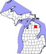
Montmorency County, Michigan Basics:


Montmorency County Michigan - Government Site

Population: 9,477
Area: 547 square miles
County seat: Atlanta
Area code(s) in use: 989
Time zone: EST
High school graduate or higher: 84.1%
Bachelor's degree or higher: 10.5%
Median household income: $34,955
Persons in poverty: 18.7%
Home ownership rate: 85.3%
Mean travel time to work: 23.8 minutes


Adjacent counties:
Alcona  Alpena  Cheboygan  Crawford  Oscoda  Otsego  Presque Isle  

Find in Michigan

Map of the Montmorency County area


Our detail map of Montmorency County shows the Montmorency County, Michigan boundary lines and other interesting items.

Places in Montmorency County, Michigan

  Airports     show all on map

Atlanta Municipal Airport, Black River Ranch Airport, Hillman Airport, Turtle Lake Club Airport, Twin Lakes Airport

  Bridges     show all on map

Barber Bridge, Shingle Mill Bridge

  Buildings     show all on map

Albert Township Hall, Albert Township Lewiston Fire Department, Atlanta Public Library, Hillman Fire and Ambulance Department, Hillman Wright Library, Lewiston Public Library, Michigan Department of Natural Resources Atlanta Forest Area, Montmorency County Courthouse, Montmorency County Sheriff's Office, Montmorency Township Hall, Tri - Township Ambulance Service, Tri - Township Fire Department, Tri - Township Fire Department Station 2, Vienna Township Volunteer Fire Department

  Capes     show all on map

Eagle Point

  Cemeteries     show all on map

Avery Cemetery, Briley Cemetery, Finnish Cemetery, Gingell Cemetery, Hillman Cemetery, Lewiston Cemetery, Loud Cemetery, Montmorency Cemetery, Rust Cemetery, Saint Augustine Cemetery, Saint Johns Cemetery

  Census     show all on map

Atlanta Census Designated Place, Canada Creek Ranch Census Designated Place, Lewiston Census Designated Place

  Channels     show all on map

Long Lake Narrows

  Churches     show all on map

Atlanta Bible Church, Atlanta Congregational Church, Atlanta Full Gospel Assembly, Bethlehem Church, Big Rock Congregational Church, Calvary Episcopal Church, Church of Christ, First Baptist Church, First Baptist Church of Atlanta, First Congregational Community Church, Hillman Free Methodist Church, Hillman United Methodist Church, Kingdom Hall of Jehovah's Witnesses, Maple Grove Brethren in Christ Church, Northern Michigan Restoration Branch Church, Pleasant Valley Church, Pleasant Valley Free Methodist Church, Saint Augustine Church, Saint Francis Church, Saint John Lutheran Church, Saint Johns Church, Saint Marks Episcopal Church

  Dams     show all on map

Rainy River Dam

  Forests     show all on map

Presque Isle State Forest

  Lakes     show all on map

Anchor Lake, Avalon Lake, Avery Lake, Bear Lake, Beaver Lake, Bedore Lake, Blue Lake, Blue Lakes, Bourne Lake, Clear Lake, Coopers Pond, Cranberry Lake, Crooked Lake, Crystal Lake, De Cheau Lake, Dollar Lake, Dollar Lake, Double Lake, East Fish Lake, East Town Corner Lake, East Twin Lake, Eleventh Lake, Ellsworth Lake, Ess Lake, First Lake, Foch Lakes, Fuller Lake, Gassel Lake, Gaylanta Lake, Gingell Lake, Grass Lake, Harder Lake, Hidden Lake, Horsehead Lake, Horseshoe Lake, Jackson Lake, Johnson Pond, Kirkland Lake, Kirtland Lake, Lake Big Wolf, Lake Fifteen, Lake Geneva, Lake Hiawatha, Lake Inez, Lake LaBarge, Lilypad Lake, Little Brush Lake, Little Crystal Lake, Little Grass Lake, Little Joe Lake, Little Wolf Lake, Lockwood Lake, Long Lake, Long Lake Pond, Long Lake Pond, Long Lake Pond, Long Lake Pond, Long Lake Pond, Lost Lake, Lower Tomahawk Lake, Lunden Lake, Marshall Pond, McCormick Lake, McMullen Lake, Middle Fish Lake, Mitchell Lake, Morning Star Lake, Muskellunge Lake, Port Wine Lake, Pug Lakes, Ribble Lake, Rush Lake, Sage Lakes, Shoepack Lake, Spectacle Lake, Spectacle Lakes, Sportsmen Lake, Stewart Lake, Sucker Lake, Sutton Pond, Thompson Pond, Town Corner Lake, Town Line Lakes, Turtle Lake, Twin Lake, Twin Tomahawk Lakes, Upper Tomahawk Lake, Valentine Lake, Virginia Lake, Voyer Lake, Walled Lake, West Fish Lake, West Town Corner Lake, West Twin Lake, Wildfowl Lake, Woodmere Lake

  Locales     show all on map

Atlanta Station (historical), Avery Lake State Forest Campground, Big Oaks State Forest Campground, Big Rock, Birdhaven Resort, Cahoon Station (historical), Camp Nakomis, Canada Creek Ranch, Comstock Tobogan Slide, Conner Station (historical), Dobbins Station (historical), Edwards School, Elk Ridge Golf Course, Ess Lake State Forest Campground, Gassel Lodge, Hillman Station (historical), Hunt Creek Fisheries Research Area, Jackson Lake State Forest Campground, Kissipee Station (historical), Lake Fifteen Campground, Lewiston Station (historical), Little Wolf Lake State Forest Campground, McCormick Lake Campground, Meaford Station (historical), Montmorency County Fairgrounds, Murrays Cabins, Organs Log Cabins, Sheridan Valley Ski Area, South Bay Campground, Thunder Bay Golf Resort, Town Corner Lake State Forest Campground, Trowbridges Resort, Valentine Lake Station (historical), Vienna Junction Station (historical), Vienna Township Hall, Watson Station (historical)

  Parks     show all on map

Angusdale Stock Farm Historical Marker, Big Rock Historical Marker, Bingham Park, Calvary Church Historical Marker, Camp Lunden Historical Marker, Clear Lake State Park, Congregational United Church of Christ Historical Marker, Hunt Creek Fisheries Research Area

  Populated Places     show all on map

Atlanta, Avery, Bigelow, Birchwood Beach, Canada Creek Ranch, Donnelly, Garland Village, Hetherton, Hillman, Lewiston, Royston, Rust, Vienna Junction

  Post Offices     show all on map

Atlanta Post Office, Big Rock Post Office (historical), Canada Creek Post Office (historical), Coffron Post Office (historical), Hetherton Post Office (historical), Hillman Post Office, Idlewild Post Office (historical), Kissipee Post Office (historical), Klein Post Office (historical), Lewiston Post Office, Royston Post Office (historical), Rust Post Office (historical), Valentine Post Office (historical), Vienna Post Office (historical)

  Reservoirs     show all on map

Rainy River Flooding

  Schools     show all on map

Albert Township School, Atlanta Junior-Senior High School, Babcock School, Cement School, Doubles School, Green School, Hillman Elementary School, Hillman Junior Senior High School, Loud School, Niergarth School, Rust School

  Streams     show all on map

Anchor Creek, Avery Creek, Barger Creek, Brush Creek, Chadwick Creek, Cole Creek, Crooked Creek, East Branch Black River, Edwards Creek, Fuller Creek, Gilchrist Creek, Grass Creek, Greasy Creek, Hardwood Creek, Haymeadow Creek, Hodge Creek, Hunt Creek, Little Brush Creek, Lockwood Creek, Long Lake Creek, Miller Creek, Montague Creek, Nugent Creek, Packer Creek, Quinn Creek, Rattlesnake Creek, Sage Creek, Sheridan Creek, Smith Creek, Stanniger Creek, Stewart Creek, Sucker Creek, Tubbs Creek, Turtle Creek, Upper South Branch Thunder Bay River, Van Hetton Creek, Weber Creek

  Summits     show all on map

Comstock Hills, Old Baldy Hill, Rattlesnake Hills

  Swamps     show all on map

Bushman Swamp, Green Swamp

  Towers     show all on map

Atlanta Lookout Tower, Comstock Fire Tower, Presque Isle South Lookout Tower, WAIR-FM (Atlanta), WCML-FM (Alpena), WCML-TV (Alpena), WPHN-FM (Gaylord),

Montmorency County, Michigan Population By Race (2012 estimate)

RacePopulation
WhiteMontmorency County White population 9,2599,259  
MixedMontmorency County Mixed population 123123
American IndianMontmorency County American Indian population 4747
BlackMontmorency County Black population 2828
AsianMontmorency County Asian population 1918
Hawaiian & Pacific IslanderMontmorency County Hawaiian & Pacific Islander population 00

Additional population tables :
State population table
Michigan population by county