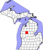
Osceola County, Michigan Basics:


Osceola County Michigan - Government Site

Population: 23,280
Area: 566 square miles
County seat: Reed City
Area code(s) in use: 231
Time zone: EST
High school graduate or higher: 86.7%
Bachelor's degree or higher: 13.1%
Median household income: $37,825
Persons in poverty: 20.0%
Home ownership rate: 78.8%
Mean travel time to work: 24.5 minutes


Adjacent counties:
Clare  Isabella  Lake  Mecosta  Missaukee  Newaygo  Wexford  

Find in Michigan

Map of the Osceola County area


Our detail map of Osceola County shows the Osceola County, Michigan boundary lines and other interesting items.

Places in Osceola County, Michigan

  Airports     show all on map

Evart Municipal Airport, McQuestions Airport, Nartron Field Airport

  Buildings     show all on map

Evart Police Department, Evart Public Library, Evart Volunteer Fire Department, Hersey Township Volunteer Fire Department, Le Roy Community Library, Leroy - Roselake Fire Department, LeRoy Museum, Lincoln Township Hall, Lincoln Township Volunteer Fire Department, Marion Area Historical Museum, Marion Community Fire Department, Marion Police Department, Marion Public Libary, Michigan Department of Natural Resources Evart Field Office, Michigan State Police Department, Old Rugged Cross Museum, Orient Township Hall, Osceola County Courthouse, Osceola County Emergency Medical Services, Osceola County Sheriff's Office, Redding Township Hall, Reed City Police Department, Reed City Public Library, Reed City Volunteer Fire Department, Sylvan Township Hall, Tustin Area Volunteer Fire Department, Tustin Community Library

  Canals     show all on map

Hoffmyer Drain, Woolley Ditch

  Cemeteries     show all on map

Ashton Cemetery, Bethel Cemetery, Bitner Cemetery, Burdell Township Cemetery, Cherry Valley Cemetery, Forest Hill Cemetery, German Cemetery, Greenwood Cemetery, Hersey Cemetery, Highland Cemetery, Hillside Cemetery, Holy Cross Catholic Cemetery, LeRoy Township Cemetery, Maple Hill Cemetery, Maple Valley Cemetery, Mennonite Cemetery, Methodist Episcopal Church Cemetery, Middle Branch Township Cemetery, Mount Olivet Cemetery, Oakdale Cemetery, Orient Cemetery, Osceola County Cemetery, Park Lake Cemetery, Proctor Family Cemetery, Rose Lake Cemetery, Saint Paul's Evangelical Lutheran Cemetery, Sherman Township Cemetery, South Evart Cemetery, Sylvan Cemetery, Trinity Lutheran Cemetery, Tustin Cemetery, Watson Road Cemetery, Wilson Cemetery, Woodland Cemetery

  Churches     show all on map

Augustana Lutheran Church, Bethel Church, Bible Missionary Church, Calvary Baptist Church, Calvary Baptist Church, Church of Antioch, Church of God, Church of the Nazarene, Church of the Nazarene, Community of Christ Church, Congregational United Church, Covenant Presbyterian Church, Crossroads Community Church, East Hersey Church, Evangel Church, Evangelical Church, Evangelical Church, Evangelical Covenant Church, Evart United Methodist Church, Faith Chapel, Faith Church, First Baptist Church, First Baptist Church, First Baptist Church of Evart, Free Methodist Church, Free Methodist Church, Harvest Assembly of God Church, Hersey Congregational Church, Hersey United Methodist Church, Kingdom Hall, Liberty Baptist Church, Marion Baptist Church, Marion Seventh Day Adventist Church, Marion United Methodist Church, Middle Branch Church, Missionary Church, Ogilvie Wesleyan Church, Pisgah Heights Wesleyan Church, Reed City Church of God, Sacred Heart Church, Saint Agnes Church, Saint Paul Lutheran Church, Saint Paul's Lutheran Church, Saint Philip Neri Catholic Church, Seventh-Day Adventist Church, South Evart Church, Trinity Lutheran Church, United Church, United Methodist Church, United Methodist Church, United Methodist Church, Zion Emanuel Lutheran Church

  Crossings     show all on map

Interchange 153, Interchange 159, Interchange 162, Interchange 168

  Forests     show all on map

Chippewa River State Forest

  Hospitals     show all on map

Countryside Health Clinic, Marion Medical Center, Mid-Michigan Medical Center, Spectrum Health - Reed City Campus, Spectrum Health Evart Clinic

  Lakes     show all on map

Alexander Lake, Asplund Lake, Austin Lake, Bammer Lake, Bass Lake, Bear Lake, Beaver Dam Lake, Big Lake, Big Long Lake, Boot Lake, Bootjack Lake, Boyd Lake, Brown Lake, Cedar Lakes, Center Lake, Cruzon Lake, Custer Lake, Decker Ponds, Deer Lake, Diamond Lake, Dollar Lake, Echelberger Lake, Eggle Lake, Eggleston Lake, Emery Lake, Fewlass Lake, Goose Lake, Halfmoon Lake, Halfmoon Lake, Hall Lake, Hay Lake, Hewitt Lake, Hicks Lake, Hogback Lake, Horsehead Lake, Horseshoe Lake, Indian Lake, John Brown Lake, Lake Lure, Lake Maloy, Lake Miramichi, Lake No Sho Mo, Lincoln Lake, Little Hogback Lake, Little Long Lake, Little Mud Lake, Little Sherwood Lake, Little Silver Lake, Little Strawberry Lake, Little Sunrise Lake, Lost Lake, Lower Big Stone Lake, Marl Bed Lake, McCoy Lake, McElwin Lake, Middle Big Stone Lake, Morgan Lake, Mud Lake, Mud Lake, Myrtle Lake, Negaunee Lake, Noggle Lake, Park Lake, Patrick Lake, Pecks Lake, Penasa Lake, Perch Lake, Perch Lake, Pitcher Lake, Rattail Lakes, Rendezvous Lake, Rice Lake, Rice Lake, Robinson Lake, Rose Lake, Round Lake, Saddlebag Lake, Sherwood Lake, Shores Pond, Shores Pond, Silver Lake, Smith Lake, Sprague Lake, Spring Lake, Strawberry Lake, Sunrise Lake, The Bayou, Tiff Lake, Todd Lake, Tubs Lake, Twin Lake, Wells Lake, Woods Lake, Wrights Lake

  Locales     show all on map

Albright Camp, Ashton Station (historical), Birch Valley Golf Course, Cadillac Woods Campground, Chippewa Station (historical), Clark School, Davis School, Dewing's Siding (historical), Dighton Station (historical), Eagle Boys Village, Evart Station (historical), Harman School, Hersey Station (historical), Kettunen Center, Leroy Station (historical), Marion Fairgrounds, Marion Station, Nash School, Noggle School, Old Log Resort and Campground, Orono Station (historical), Park Lake Station, Reed City Station (historical), River Country Campground, Riverbank Station (historical), Rose Golf Course, Rose Lake School, School Number 1, Sears Station (historical), Sherman School, Shields School, Spring Hill Camp, Spring Valley Golf Course, Sunrise Lake State Forest Campground, Tustin Rest Area, Tustin Station (historical), Tustin Trails Golf Course

  Oilfields     show all on map

Cedar Oil and Gas Field, Mineral Springs Oil Field

  Parks     show all on map

Albright Park, Congregational Church Historical Marker, Crawford Park, Crittenden County Park, Founding of Marion Historical Marker, John E Larson Farm Historical Marker, Joseph W Guyton Historical Marker, Linear Park, Marion Millpond and Dam Historical Marker, North Evart United Methodist Church Historical Marker, Rambadt Memorial Park, Riverside City Park, Rose Lake Park, Swedish Evangelical Lutheran Church Historical Marker, Unto a New Land Historical Marker, Westerburg Memorial Park

  Populated Places     show all on map

Ashton, Avondale, Chippewa, Dewing's (historical), Dighton, Evart, Gibos Corners (historical), Hersey, Highland, Ina, Le Roy, Marion, Orono, Park Lake, Pisgah Heights, Reed City, Sears, Slaybaugh Corner, Tustin, White Birch Estates Mobile Home Park, Youngs Trailer Park

  Post Offices     show all on map

Ashton Post Office (historical), Avondale Post Office (historical), Brazil Post Office (historical), Brookside Post Office (historical), Chippewa Station Post Office (historical), Dewings Post Office (historical), Dighton Post Office (historical), Earl Post Office (historical), Evart Post Office, Frielingville Post Office (historical), Gormer Post Office (historical), Hartwick Post Office (historical), Headland Post Office (historical), Hersey Post Office, Ina Post Office (historical), Le Roy Post Office, Marion Post Office, Milburn Post Office (historical), Orient Post Office (historical), Orono Post Office (historical), Parklake Post Office (historical), Penesa Post Office (historical), Randolph Post Office (historical), Reed City Post Office, Riverbank Post Office (historical), Roselake Post Office (historical), Sears Post Office, Tustin Post Office

  Reservoirs     show all on map

Mill Pond

  Schools     show all on map

Avondale School, Beebe School, Bennett School, Brooks School, Burt School, Daystar Christian Academy, Dighton School, Evart Elementary School, Evart High School, Evart Middle School, Gormer School, GT Norman Elementary School, Heritage Christian Academy, Hewitt School, Highland School, Hillcrest School, Hoover School, Kidder School, Le Roy Elementary School, Maple Hill School, Maple Ridge School, Marion Elementary School, Marion High School, Martin School, Morris School, Ogilvie School, Pine River Area High School, Reed City High School, Rehkoff School, Robinson School, Sawyer School, Shingletown School, Sylvan School, Trinity Lutheran School, Tustin Elementary School, Upper Elementary School, Warson School, Wilson School

  Streams     show all on map

Appleby Creek, Atkinson Creek, Beaver Creek, Beebe Creek, Big Stone Creek, Browne Creek, Bull Kill Creek, Burt Creek, Cat Creek, Chippewa Creek, Crocker Creek, Diamond Lake Outlet Creek, Doc and Tom Creek, East Branch Hersey Creek, East Branch Pine River, Franz Creek, Grindstone Creek, Hersey Creek, Hersey River, Hewitt Creek, Hicks Creek, Hoffmyer Creek, Indian Creek, Jewitt Creek, Johnson Creek, Johnson Creek, Johnson Creek, Johnson Creek, Kinney Creek, Kissinger Creek, Lake Outlet, Lawrence Creek, Lincoln Creek, Little Beaver Creek, Middle Branch River, Mud Creek, North Branch Pine River, Olson Creek, Polick Creek, Posted Creek, Rose Edgett Creek, Ryan Creek, Sandy Run, Sherlock Creek, Sprague Creek, Thompson Creek, Thorn Creek, Twin Creek, Twin Creek, West Branch Middle Branch River, Whetstone Creek

  Swamps     show all on map

Whitmore Pond

  Towers     show all on map

Cadillac Lookout Tower, Hartwick Lookout Tower, WCMV-TV (Cadillac), WDEE-AM (Reed City), WGKI-TV (Cadillac), WKJF-FM (Cadillac), WWTV-TV (Cadillac),

Osceola County, Michigan Population By Race (2012 estimate)

RacePopulation
WhiteOsceola County White population 22,51222,511  
MixedOsceola County Mixed population 419419
BlackOsceola County Black population 163162
American IndianOsceola County American Indian population 140139
AsianOsceola County Asian population 4746
Hawaiian & Pacific IslanderOsceola County Hawaiian & Pacific Islander population 00

Additional population tables :
State population table
Michigan population by county