Schoolcraft County, Michigan Basics:


Schoolcraft County Michigan - Government Site

Population: 8,344
Area: 1171 square miles
County seat: Manistique
Area code(s) in use: 906
Time zone: EST
High school graduate or higher: 89.0%
Bachelor's degree or higher: 12.3%
Median household income: $37,468
Persons in poverty: 18.3%
Home ownership rate: 85.6%
Mean travel time to work: 17.5 minutes

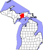
Adjacent counties:
Alger  Delta  Luce  Mackinac  

Find in Michigan

Map of the Schoolcraft County area


Our detail map of Schoolcraft County shows the Schoolcraft County, Michigan boundary lines and other interesting items.

Places in Schoolcraft County, Michigan

  Airports     show all on map

Bass Lake Airport, Doyle Township Emergency Landing Field, Schoolcraft County Airport

  Bars     show all on map

Wiggins Point Shoal

  Bays     show all on map

Goadreaus Harbor, Langes Bay, Little Harbor, Parent Bay, Seul Choix Bay

  Bridges     show all on map

Siphon Bridge

  Buildings     show all on map

Doyle Township Fire Department, Germfask Volunteer Fire Department, Hiawatha Township Volunteer Fire Department, Inwood Fire and Rescue, Manistique Ambulance Service, Manistique City Hall, Manistique Department of Public Safety Fire Station, Manistique Public Library, Michigan Department of Natural Resources Seney Field Office, Schoolcraft County Courthouse, Schoolcraft County Sheriff's Office, Schoolcraft Historical Museum, Seney Township Fire Department, Thompson Township Fire Department, United States Forest Service Manistique Ranger Station

  Canals     show all on map

Clarks Ditch, East West Ditch, Holland Ditch, Spur Ditch, Sweeney Ditch, Twomile Ditch, Unit Number One Diversion Ditch, Unit Number Two Diversion Ditch, Walsh Ditch

  Capes     show all on map

Ash Point, Bourassas Point, Cole Point, Dutch Johns Point, Hiram Point, Miller Point, Pillows Point, Point aux Barques, Point O'Keefe, Rocky Point, Seul Choix Point, Stony Point, Wiggins Point

  Cemeteries     show all on map

Blaney Cemetery, Boot Hill Cemetery, Byers Cemetery, Cooks Cemetery, Fairview Cemetery, Farley Grave Site, Germfask Cemetery, Hiawatha Cemetery, Lakeview Cemetery, Old Cooks Cemetery, Old Germfask Cemetery, Seventh Day Adventist Cemetery, Thompson Cemetery, Woods Cemetery

  Churches     show all on map

Bethel Baptist Church, Cedar Grove Mennonite Church, Cooks Congregational Church, Divine Infant of Prague Church, Faith Church, First Baptist Church, First United Methodist Church, Germfask Church, Germfask United Methodist Church, Grace Church, Kingdom Hall of Jehovah's Witnesses, Manistique Bible Church, Manistique Harbor Pentecostal Church, Maple Grove Church, Mercy Apostolic Church, Presbyterian Church, Saint Alban's Episcopal Church, Saint Francis de Sales Church, Seventh Day Adventist Church, Zion Lutheran Church

  Flats     show all on map

The Spreads

  Forests     show all on map

Grand Sable State Forest

  Guts     show all on map

Island Slough, Johnson Creek, Silver Creek

  Hospitals     show all on map

Rural Health Clinic, Schoolcraft Memorial Hospital

  Lakes     show all on map

Aldrich Lake, Anderson Lake, Ashford Lake, Banana Lake, Barnhart Lake, Bass Lake, Bear Town Slough, Beaton Lake, Bell Lake, Big Island Lake, Black Lake, Blue Joe Lake, Bluegill Lake, Bonnet Lake, Boot Lake, Bootjack Lake, Brassel Slough, Brevick Lake, Buck Lake, Bursaw Marsh, Byers Lake, Calspar Quarry Pool, Camp Nine Lakes, Camp Number 11 Slough, Canoe Lake, Carpenter Lake, Catfish Slough, Cedar Lake, Cedar Lake, Center Lake, Chip Lake, Clear Creek Trout Pond, Clear Lake, Clear Lake, Clear Slough, Clemons Lake, Coattail Lake, Colwell Lake, Cookson Lake, Cookson Lake, Cornell Lake, Cornell Lake, Cranberry Lake, Cranberry Lake, Crane Lake, Crescent Lake, Crooked Lake, Cucumber Lake, Cusino Lake, Dark Lake, Davis Slough, Deacon Lake, Dinner Lake, Dipper Lake, Dodge Lake, Doyle Lake, Doyle Lake, Driggs Lake, Duck Hole Lake, Dutch Fred Lake, Eagle Lake, East Lake, Farm Lake, Fawn Lake, Ford Lake, Fork Lake, Frankes Lake, Gemini Lakes, Ghost Lake, Grass Lake, Grassy Lake, Green Bass Lake, Green Pond, Greenway Lake, Gulliver Lake, Harcourt Lake, Herman Lake, Hub Lake, Hughes Lake, Hutt Lake, Indian Lake, Ironjaw Lake, Island Lake, Island Lake Slough, Jack Lake, Jamestown Slough, Jarr Lake, Kennedy Lake, Kepler Lake, Kimble Lake, Kings Pond, Klegstads Slough, Klondike Lake, Lake Anne Louise, Lard Lake, Leg Lake, Lily Lake, Little Bass Lake, Little Boot Lake, Little Island Lake, Little Lake, Little Muddy Lake, Little Murphy Lake, Little Ross Lake, Lone Lake, Long Lake, Lorraine Lake, Lost Lake, Lost Lake, Mahoney Lake, Makel Lake, Marblehead Lake, McDonald Lake, McGinn Lake, McInnes Lake, McIntyre Lake, McKeever Lake, Merwin Lake, Mezik Lake, Michaud Lake, Mid Lake, Mike White Lake, Millaquaka Lake, Minerva Lake, Minnow Lake, Moon Lake, Mud Lake, Muleshoe Lakes, Murphy Lake, Neds Lake, Neighbor Lake, Nevilles Lake, Ninemile Lake, Nineteen Lake, No Name Lake, Onega Lake, Ostrander Lake, Otter Lake, Palmer Lake, Peanut Lake, Pear Lake, Pelkys Lake, Perch Lake, Petes Lake, Petite Lake, Pewee Lake, Plains Lake, Red Lake, Rim Lake, River Slough, Rose Lake, Ross Lake, Rumble Lake, Salter Lake, Sand Lake, Section Seven Lake, Shoepac Lake, Shuberts Lake, Side Lake, Silver Lake, Skeels Lake, Smith Lake, Smith Slough, Snyder Lake, Spring Lake, Spring Pond, Sprinkler Lake, Spud Lake, Stanley Lake, Steuben Lake, Stewart Lake, Stoner Pond, Straits Lake, Stump Lake, Sucker Lake, Sunken Lake, Swan Lake, Tad Lake, Taylor Lake, Tee Lake, Three Island Lake, Thunder Lake, Tighe Lake, Toms Lake, Townline Lake, Triangle Lake, Trout Lake, Tucker Lake, Twilight Lake, Twin Lakes, Upper Lake, Upper Thunder Lake, Vance Lake, Verdant Lake, Wedge Lake, Woodruff Lake, Worchester Lake

  Levees     show all on map

Riverside Dike

  Locales     show all on map

Big Cedar Campground, Blue Heron Golf Course, Canoe Lake State Forest Campground, Clear Lake Organization Camp, Colwell Lake Campground, Cooks Station, Corner Lake Recreation Area, Creighton Station, Cusino Lake State Forest Campground, Cusino Station (historical), East Branch Fox River State Forest Campground, Fox River Campground, Fox River Public Access, Germfask Station (historical), Gulliver Station, Hartman Camp, Hiawatha, Hiawatha Shores, Howards Camp, Indian Lake Campground, Indian Lake Campground, Indian Lake Golf Course, Indian Lake State Park Campground, Indian Lake Travel Resort Campground, Indian River Campground, Little Bass Lake Campground, Manistique Light, Manistique Municipal Marina, Manistique Station, Mead Creek Campground, Merwin Creek Campground, North Gemini Lake State Forest Campground, Parkington Station, Petes Lake Recreation Area, Ross Lake State Forest Campground, Schoolcraft County Fairgrounds, Scotts, Seney Station, Seul Choix Point Lighthouse, South Gemini Lake State Forest Campground, South Manistique Station (historical), Stanley Lake Campground, Steuben Station (historical), Thompson State Fish Hatchery, Township Campground, United States Forest Service, Walsh Station, West Branch Campground, West Breakwater Light, West Pierh Light, Wigwam Picnic Area, Woodstar Beach Campground

  Parks     show all on map

Bishop Baraga's First Church Historical Marker, Indian Lake State Park, Lakeview Park, Lime Kilns Historical Marker (historical), Manistique Township Park, Palms Book State Park, Rogers Park, Seney National Wildlife Refuge, Thompson/Christmas Tree Ship Historical Marker

  Populated Places     show all on map

Blaney Junction, Blaney Park, Cooks, Copenhagen Beach, Creighton, Cusino, Elkhorn, Evergreen Shores, Germfask, Gulliver, Harrison Beach, Hiawatha, Inland, Lavender Corner, Manistique, Michiwaukee Shores, Minor Beach, Ossawinamakee Beach, Parkington, Pines, Richardsons Mill, Seney, Springer, Steuben, Sunset Beach, Thompson, Walsh

  Post Offices     show all on map

Blaney Park Post Office (historical), Calspar Post Office (historical), Cooks Post Office, Cusino Post Office (historical), Germfask Post Office, Gulliver Post Office, Hiawatha Post Office (historical), Little Harbor Post Office (historical), Manistique Post Office, Parkington Post Office (historical), Seney Post Office, South Manistique Post Office (historical), Steuben Post Office (historical), Thompson Post Office (historical), Walsh Post Office (historical)

  Rapidss     show all on map

Stone Rapids

  Reserves     show all on map

Big Island Lake Wilderness, Seney Wilderness

  Reservoirs     show all on map

A Pool, A-Two Pool, B Pool, C Pool, C-Three Pool, C-Two Pool, D Pool, Delta Creek Pool, E Pool, F Pool, G Pool, H Pool, I Pool, J Pool, Lower Goose Pen Pool, M Pool, Marsh Creek Pool, Mud Lake, Spur Pool, Sweeney Pool, T Pool, The Reservoir, Upper Goose Pen Pool

  Schools     show all on map

Bethel Baptist Christian School, Cooks School, Cooks School, Emerald Elementary School, Fairview School, Hiawatha School, Lincoln Elementary School, Manistique High School, Saint Francis De Sales School, Woods School

  Springs     show all on map

Big Spring

  Streams     show all on map

Anderson Creek, Bear Creek, Bear Creek, Bear Creek, Bear Slough, Beaver Creek, Big Murphy Creek, Birch Creek, Black Creek, Black Creek, Boucher Creek, Brace Creek, Bulldog Creek, Bursaw Creek, Camp Eightthree Creek, Camp Seven Creek, Carr Creek, Clear Creek, Clemons Creek, Cold Creek, Commencement Creek, Creighton River, Cub Bear Creek, Dead Creek, Dead Creek, Dead Horse Creek, Deer Creek, Delias Run, Delta Creek, Dougal Creek, Driggs River, Dry Creek, Ducey Creek, Duck Creek, Dufour Creek, East Branch Bear Creek, East Branch Fox River, Fenton Creek, Fernia Creek, Four Hundred and Five Creek, Fox River, Gents Creek, Gierke Creek, Goulds Slough, Grassy Creek, Gray Duck Creek, Grays Creek, Grindstone Creek, Gronden Creek, Gronden Creek, Gulliver Lake Outlet, Hay Meadow Creek, Hay Meadow Creek, Haymeadow Creek, Hiawatha Creek, Hickey Creek, Holland Creek, Hudson Creek, Indian River, Indian River, Iron Creek, Kilpecker Creek, Leg Creek, Little Bear Creek, Little Duck Creek, Little Fox River, Little Indian River, Little Murphy Creek, Little Star Creek, Mahoney Creek, Manistique River, Marblehead Creek, Marsh Creek, Mead Creek, Merwin Creek, Mezik Creek, Middle Branch Stutts Creek, Milakokia River, Negro Creek, Nelson Creek, North Branch Stutts Creek, Orr Creek, Otter Creek, Parent Creek, Pelky Creek, Pine Creek, Pine Creek, Poodle Pete Creek, Ross Creek, Sand Creek, Sand Creek, Section Nineteen Creek, Shotgun Creek, Smith Creek, Snyder Creek, Snyder Creek, Snyder Creek, South Branch Stutts Creek, Southside Creek, Southtown Creek, Spring Creek, Star Creek, Stoner Creek, Sturgeon Hole Creek, Sturgeon Hole Slough, Stutts Creek, Tad Creek, Tebo Creek, Thompson Creek, Trail Creek, Walsh Creek, West Branch Fox River, West Branch Hickey Creek, West Branch Manistique River, Williams Creek

  Summits     show all on map

Blue Mountains

  Swamps     show all on map

Bear Creek Swamp, Creighton Marsh, Driggs Marsh, Scotts Marsh, The Spreads

  Towers     show all on map

Cooks Lookout Tower, Steuben Lookout Tower, WTIQ-AM (Manistique), WTIQ-FM (Gulliver), WTIQ-FM (Gulliver)

  Trails     show all on map

Big Island Lake Portage Canoe Trail, Haywire Grade ORV Trail, High Rollways Truck Trail,

Schoolcraft County, Michigan Population By Race (2012 estimate)

RacePopulation
WhiteSchoolcraft County White population 7,2597,259  
American IndianSchoolcraft County American Indian population 759759
MixedSchoolcraft County Mixed population 292292
AsianSchoolcraft County Asian population 1716
Hawaiian & Pacific IslanderSchoolcraft County Hawaiian & Pacific Islander population 00

Additional population tables :
State population table
Michigan population by county