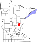
Kanabec County, Minnesota Basics:


Kanabec County Minnesota - Government Site

Population: 16,004
Area: 522 square miles
County seat: Mora
Area code(s) in use: 320
Time zone: CST
High school graduate or higher: 86.4%
Bachelor's degree or higher: 13.6%
Median household income: $46,323
Persons in poverty: 13.1%
Home ownership rate: 81.5%
Mean travel time to work: 33.0 minutes


Adjacent counties:
Aitkin  Chisago  Isanti  Mille Lacs  Pine  

Find in Minnesota

Map of the Kanabec County area


Our detail map of Kanabec County shows the Kanabec County, Minnesota boundary lines and other interesting items.

Places in Kanabec County, Minnesota

  Airports     show all on map

Conley Field, Kanabec Hospital Heliport, Mora Municipal Airport

  Areas     show all on map

Lake Five State Wildlife Management Area

  Buildings     show all on map

Mora Area Fire Department, Ogilvie Volunteer Fire Department

  Canals     show all on map

County Ditch Number Five, County Ditch Number Four, County Ditch Number One, County Ditch Number Ten

  Cemeteries     show all on map

Graceland Cemetery, Grass Lake Cemetery, Grasston Union Cemetery, Knife Lake Cemetery, Mission Cemetery, Riverside Cemetery, Saint Kathryn Cemetery, Saint Marys Cemetery, Trinity Cemetery

  Churches     show all on map

Brunswick Church, Fish Lake Church, Hillman Church, Lewis Lake Church, Pomroy Union Chapel, Saint John Church

  Dams     show all on map

Ann River Dam, Bergstedt Dam, Carda Impoundment Dam, Emanuel Bachman Dam, Ernest Linder Wildlife Pond Dam, Forshier Pool Dam, Foshier Group Farm Pond Dam, Gus Herwig Dam, Knife Lake Dam, Mud Lake Dam, Richards Pond Dam, William Peal Junior Memorial Dam

  Forests     show all on map

Snake River State Forest

  Hospitals     show all on map

FirstLight Health System Hospital

  Lakes     show all on map

Beauty Lake, Devils Lake, Featherbed Lake, Grass Lake, Kent Lake, Lake Eleven, Lake Five, Lake Full of Fish, Lake Seven, Lake Twelve, Lewis Lake, Long Lake, Luchts Lake, McMullen Lake, Mora Lake, Mud Lake, Peace Lake, Pennington Lake, Pomroy Lake, Rice Lake, Rice Lake, Sells Lake, Snowshoe Lake, Spence Lake, Spring Lake, Thirteen Lake, Twin Lakes, White Lily Lake

  Locales     show all on map

Knife Lake Dairy, Mora Golf Course, Spring Brook Golf Course

  Parks     show all on map

Ann Lake State Wildlife Management Area, Bean Dam State Wildlife Management Area, Hay-Snake State Wildlife Management Area, Indian Mounds Park, Rice Creek State Wildlife Management Area, Tosher Creek State Wildlife Management Area, Whited State Wildlife Management Area

  Populated Places     show all on map

Brunswick, Coin, Grass Lake, Grasston, Kroschel, Lewis Lake, Mora, Ogilvie, Quamba, Warman, Woodland

  Reservoirs     show all on map

Ann Lake, Bachman Dam, Bergstedt Dam, Carda Impoundment Reservoir, Fish Lake, Fish Lake, Forshier Pool, Foshier Pond, Gust Herwigs Fish Pond, Knife Lake, Louis Richards Reservoir, Mud Lake

  Schools     show all on map

Hawthorne School, Lakeview School, Monroe School

  Streams     show all on map

Ann River, Bean Brook, Bergman Brook, Camp Creek, Chelsey Brook, Groundhouse River, Hay Creek, Knife River, Little Ann River, Mackey Brook, Mud Creek, Rice Creek, Snowshoe Brook, South Fork Groundhouse River, Spring Brook, Spring Brook

  Towers     show all on map

KBEK-FM (Mora),

Kanabec County, Minnesota Population By Race (2012 estimate)

RacePopulation
WhiteKanabec County White population 15,54015,539  
MixedKanabec County Mixed population 240240
American IndianKanabec County American Indian population 9696
BlackKanabec County Black population 8080
AsianKanabec County Asian population 6464
Hawaiian & Pacific IslanderKanabec County Hawaiian & Pacific Islander population 00

Additional population tables :
State population table
Minnesota population by county