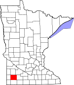
Murray County, Minnesota Basics:
Murray County Minnesota - Government Site
Population: 8,570
Area: 705 square miles
County seat: Slayton
Area code(s) in use: 507
Time zone: CST
High school graduate or higher: 89.5%
Bachelor's degree or higher: 16.3%
Median household income: $50,039
Persons in poverty: 10.1%
Home ownership rate: 82.9%
Mean travel time to work: 18.5 minutes
Adjacent counties:
Cottonwood Lyon Nobles Pipestone Redwood Rock
Places in Murray County, Minnesota
Dairyview Airport,
Slayton Municipal Airport Indian Bay,
The Inlet Avoca Fire Department,
Chandler Volunteer Fire Department,
Currie Volunteer Fire Department,
Dovray Fire Department,
Fulda Fire Department,
Fulda Memorial Library,
Fulda Police Department,
Fulda Village Ambulance Service,
Hadley Area Community Center,
Iona Fire Department,
Lake Wilson Fire Department,
Murray County Courthouse,
Murray County Museum,
Murray County Sheriff Department,
Slayton Fire Department,
Slayton Police Department,
Slayton Public Library County Ditch Number Eighteen,
County Ditch Number Eighty,
County Ditch Number Four,
County Ditch Number Ninteen,
County Ditch Number Twenty,
County Ditch Number Twentyone,
Judicial Ditch Number Fourteen,
Judicial Ditch Number Fourteen,
Judicial Ditch Number Ten,
Judicial Ditch Number Twenty,
Judicial Ditch Number Twenty A Blocks Point,
Bowmans Point,
Rauenhorst Point,
Stoney Point,
Wolf Point Badger Lake Presbyterian Cemetery,
Bethany Cemetery,
Chandler Memorial Cemetery,
Currie Pioneer Cemetery,
Ellsborough Cemetery,
Emmanuel Cemetery,
Faith Cemetery,
Faith Swedish Cemetery,
Highland Home Cemetery,
Hillside Cemetery,
Lake Sarah Cemetery,
Modum Cemetery,
Old German Cemetery,
Our Saviors Cemetery,
Prairie Hill Cemetery,
Restland Memory Gardens, Rupp Cemetery,
Saint Annes Cemetery,
Saint Columba Cemetery,
Saint Gabriel Cemetery,
Saint John's Cemetery,
Saint Rose Cemetery,
Sillerud Cemetery,
Skandia Cemetery,
Slayton Cemetery,
Trinity Cemetery,
Willow Lake Cemetery,
Zion Lutheran Cemetery,
Zion Lutheran Church Cemetery The Lakes Census Designated Place Assembly of God Church,
Chandler Christian Church,
Chandler Reformed Church,
Christ Lutheran Church,
Ellsborough Church,
Faith Lutheran Church,
First Presbyterian Church,
First Presbyterian Church,
First Reformed Church,
Good Shepherd Lutheran Church,
Hadley Lutheran Church,
Holly Church,
Immaculate Heart of Mary Church,
Immanuel Lutheran Church,
Lake Sarah Church,
Our Saviour's Lutheran Church,
Saint Ann's Catholic Church,
Saint Gabriels Church,
Saint Mary's Catholic Church,
Saint Paul's Lutheran Church,
Saint Peter's Lutheran Church,
Sillerud Church,
Skandia Church,
Slayton Baptist Church,
Trinity Lutheran Church,
Trinity Lutheran Church,
United Methodist Church,
United Methodist Church,
Willow Lake Church,
Zion Church Fulda Lake Dam,
Post Group Detention Reservoir Dam,
Sarah Lake Dam,
Shetek Lake Dam Bear Lakebed,
Beauty Lakebed,
Clear Lakebed,
Crooked Lakebed,
Duck Lakebed,
Great Oasis Lakebed,
Ivadelle Lakebed,
Jim Lakebed,
Long Lakebed,
Mud Lakebed,
Oscar Lakebed,
Rush Lakebed,
Rush Lakebed,
Snow Lakebed,
Star Lakebed Chandler Clinic,
Currie Clinic,
Fulda Clinic,
Maple Lawn Nursing Home,
Murray County Medical Center,
Slayton Clinic,
Slayton Manor Care Center Keeley Island,
Loon Island,
Valhalla Island Armstrong Slough,
Big Slough,
Bloody Lake,
Breezy Point,
Buffalo Lake,
Corabelle Lake,
Current Lake,
Fox Lake,
Fremont Lake,
Fulda First Lake,
Fulda Second Lake,
Hanover Slough,
Hjermstad Lake,
Hjermstad Slough,
Iron Lake,
Klinker Slough,
Lake Julia,
Lake Louisa,
Lake Maria,
Lake Sarah,
Lake Shetek,
Lake Wilson,
Lime Lake,
Moon Lake,
North Badger Lake,
Park Lake,
Robbins Slough,
Round Lake,
Slaughter Slough,
Smith Lake,
South Badger Lake,
Summit Lake,
Webster Slough,
Willow Lake Avoca (historical),
C and M Farms,
Chandler (historical),
Currie (historical),
Dovray (historical),
Fulda (historical),
Gleis Farms,
Hadley (historical),
Hurd Hog Farms,
Iona Lake (historical),
Lake Wilson (historical),
Lime Creek (historical),
Lime Lake Rest Area,
Miller Farm,
Rolling Hills Golf Club,
Ruthton Farms,
Rylaarsdam Dairy Farm,
Schreiers on Shetek Campground,
Shetek Church Camp,
Slayton (historical),
Slayton Country Club,
Slayton Wastewater Treatment Plant,
Stonegate Orchard,
Town and Country Golf Club,
Valhalla Island Campground,
Wolf Point Campground Chandler Air Force Station (historical) Avoca Historical Marker,
Avoca State Wildlife Management Area,
Badger Lake State Wildlife Management Area,
Bergman State Wildlife Management Area,
Big Slough State Wildlife Management Area,
Buffalo Lake State Wildlife Management Area,
Chandler State Wildlife Management Area,
County Line State Wildlife Management Are,
Current Lake State Wildlife Management Area,
Dovray State Wildlife Management Area,
End-O-Line Railroad Park,
Great Oasis State Wildlife Management Area,
Haberman State Wildlife Management Area,
Hjermstad Lake State Wildlife Management Are,
Irrupption State Wildlife Management Area,
Klinker State Wildlife Management Area,
Lake Shetek State Monument,
Lake Shetek State Park,
Lange State Wildlife Management Area,
Leeds State Wildlife Management Area,
Lowville State Wildlife Management Areas,
Mason State Wildlife Management Area,
McCord-Laible State Wildlife Management,
Nelson State Wildlife Management Area,
Peters State Wildlife Management Area,
Phelan State Wildlife Management Area,
Reinhold State Wildlife Management Area,
Rupp State Wildlife Management Area,
Ruthton State Wildlife Management Area,
Schoeberl State Wildlife Management Area,
Shetek State Wildlife Management Area,
Skandia State Wildlife Management Area,
Sweetman State Wildlife Management Area,
Tutt State Wildlife Management Area,
Van Eck State Wildlife Management Area Avoca,
Chandler,
Current Lake,
Currie,
Dovray,
Fulda,
Hadley,
Iona,
Lake Wilson,
Lime Creek,
Lowville,
Owanka,
Slayton,
The Lakes,
Wirock Avoca Post Office, Cameron Post Office (historical),
Chandler Post Office,
Current Lake Post Office (historical),
Currie Post Office,
Dovray Post Office, East Des Moines Post Office (historical), Fairview Post Office (historical),
Fulda Post Office,
Hadley Post Office, Ibsen Post Office (historical),
Iona Post Office, Iron Lake Post Office (historical), Kelley Post Office (historical),
Lake Wilson Post Office, Leeds Post Office (historical),
Lime Creek Post Office (historical), Lime Stone Post Office (historical), Louisa Post Office (historical),
Lowville Post Office (historical), Mason Post Office (historical), Murray Centre Post Office (historical),
Owanka Post Office (historical), Prairie Lodge Post Office (historical), Scovell Post Office (historical), Shetic Post Office (historical),
Slayton Post Office, Thrall Post Office (historical),
Wirock Post Office (historical) Fulda Lake,
Sarah Lake,
Shetek Lake Buffalo Ridge Chandler - Lake Wilson Elementary School,
Chandler Christian School,
Fulda Grade School,
Fulda Secondary School,
Murray County Central High School,
Saint Paul's Lutheran School,
School Number 1254,
School Number 1261,
School Number 1264,
West School Beaver Creek,
Devils Run,
Lime Creek,
North Branch Chanarambie Creek,
Willow Creek Poverty Hill Clear Lake KFDU-FM (Slayton),
KISD-FM (Pipestone),
KRSW-FM (Worthington-Marshall),

