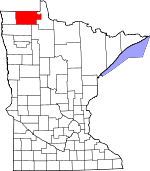
Roseau County, Minnesota Basics:


Roseau County Minnesota - Government Site

Population: 15,505
Area: 1672 square miles
County seat: Roseau
Area code(s) in use: 218
Time zone: CST
High school graduate or higher: 90.1%
Bachelor's degree or higher: 17.0%
Median household income: $50,620
Persons in poverty: 10.4%
Home ownership rate: 77.6%
Mean travel time to work: 15.9 minutes


Adjacent counties:
Beltrami  Kittson  Lake of the Woods  Marshall  

Find in Minnesota

Map of the Roseau County area


Our detail map of Roseau County shows the Roseau County, Minnesota boundary lines and other interesting items.

Places in Roseau County, Minnesota

  Airports     show all on map

Erickson Airport, Greenbush Municipal Airport, Piney Pinecreek Border Airport, Roseau Municipal Airport/Rudy Billberg Field, Warroad International Memorial Airport

  Bridges     show all on map

Scifres Bridge

  Buildings     show all on map

Badger Fire Department, Greenbush Branch Library, Greenbush Police Department, Greenbush Volunteer Fire Department, Kruta Hall, Malung Hall, Minnesota Department of Natural Resources Forestry Division Wannaska Field Office, Minnesota Department of Natural Resources Forestry Division Warroad Area Office, Roseau City Library, Roseau County Courthouse, Roseau County Sheriff Department, Roseau Fire Department, Roseau Police Department, Warroad City Hall, Warroad City Library, Warroad Fire Department, Warroad Heritage Center and Museum, Warroad Police Department

  Canals     show all on map

County Ditch Number Eight, County Ditch Number Eighteen, County Ditch Number Eleven, County Ditch Number Five, County Ditch Number Four, County Ditch Number Nine, County Ditch Number Seven, County Ditch Number Seventeen, County Ditch Number Six, County Ditch Number Sixteen, County Ditch Number Thirteen, County Ditch Number Twenty, County Ditch Number Twentyfive, County Ditch Number Twentyfour, County Ditch Number Twentyone, County Ditch Number Twentysix, County Ditch Number Twentythree, Judicial Ditch Number Sixtyone, Judicial Ditch Number Thirtythree, Lateral Ditch Number Nine, Lateral Ditch Number One, Lateral Ditch Number Two, Pine Creek Ditch, State Ditch Number Nintyone, State Ditch Number Sixtynine, Whitney Lake Ditch

  Cemeteries     show all on map

America Cemetery, Badger Cemetery, Badger Creek Cemetery, Barnett Cemetery, Beaver Cemetery, Bethania Cemetery, Bethania Cemetery, Bethel Cemetery, Bethel Cemetery, Bethesda Cemetery, Bethlehem Cemetery, Bethlehem Cemetery, Concordia Cemetery, Elkwood Cemetery, Elkwood Cemetery, Fairview Cemetery, Falun Cemetery, Golden Valley Cemetery, Greenwood Cemetery, Gust National Cemetery, Hope Cemetery, Immanuel Cemetery, Juneberry Cemetery, Klondike Cemetery, Lorenson Cemetery, Malung Cemetery, Mellum Cemetery, Mickinock Cemetery, Nannestad Cemetery, Oak Hill Cemetery, Oiland Cemetery, Opdahl Cemetery, Palmville Cemetery, Pauli Cemetery, Pine Grove Cemetery, Pine Ridge Cemetery, Poplar Grove Cemetery, Reine Cemetery, Riverside Cemetery, Rose Cemetery, Roselund Cemetery, Sacred Heart Cemetery, Saint Joseph Cemetery, Saint Mary Cemetery, Saint Marys Cemetery, Saint Phillips Cemetery, Salem Cemetery, Salol Mission Cemetery, Spruce Cemetery, Spruce Cemetery, Swedish Cemetery, Zion Cemetery

  Churches     show all on map

Assumption Church, Badger Creek Free Lutheran Church, Bethel Church, Bethel Church, Bethel Lutheran Church, Bethesda Church, Bethlehem Church, Bethlehem Church, Bethlehem Evangelical Lutheran Church, Blessed Sacrament Church, Church of Jesus Christ of Latter-Day Saints, Concordia Church, Evangelical Covenant Church, Faith Church, First Baptist Church, First Lutheran Church, Give Glory to God Church, Kingdom Hall of Jehovah's Witnesses, Mennonite Church, Messiah Lutheran Church, Moe Lutheran Church, Nannestad Church, New Life Assembly of God Church, Norland Church, Norland Free Lutheran Church, Oiland Church, Our Redeemer Lutheran Church, Palmville Church, Pauli Church, Pelan Pioneer Chapel, Pine Grove Church, Pinecreek Church, Poplar Grove Church, Riverside Lutheran Church, Rose Church, Roseau Community Church, Roselund Church, Ross Lutheran Parish, Sacred Heart Catholic Church, Saint Aloysius Church, Saint Joseph Church, Saint Mary's Catholic Church, Saint Mary's Catholic Church, Saint Peters Episcopal Church, Saint Philips Church, Salem Church, Salol First Lutheran Church, Seventh Day Adventist Church, Spruce Church, Stafford Church, Union Congregational Church, United Free Lutheran Church, United Methodist Church, Warroad Baptist Church, Warroad Free Lutheran Church, Woodland Bible Church, Zion Church, Zion Lutheran Church

  Dams     show all on map

Hayes Lake Dam, Roseau River Wildlife Management Area Pool 1 Dam, Roseau River Wildlife Management Area Pool 2 Dam, Roseau River Wildlife Management Area Pool3 Dam

  Flats     show all on map

Roseau Lakebed

  Forests     show all on map

Lost River State Forest

  Hospitals     show all on map

Altru Clinic, Altru Clinic, Altru Community Clinic, Greenbush Community Nursing Home, LifeCare Medical Center, Sheltering Oaks Manor, Warroad Care Center

  Islands     show all on map

Popple Island, Springsteel Island

  Lakes     show all on map

Carlson Pothole, Doughnut Pothole, Hanks Lake, Marvin Lake, Mud Lake

  Locales     show all on map

Badger Station, Bemis Hill Campground, Deer Ridge Dairy, Fox Station, Greenbush Station, Mandus Station (historical), Roosevelt Station, Roseau Oakcrest Golf Club, Roseau RV Park, Roseau Station, Salol Station, Springsteel Resort, Strathcona Station, Swift Station, Walsh Farm, Warroad City Campground, Warroad Estates Golf Course, Warroad Estates RV Park, Warroad Station

  Parks     show all on map

Fort Saint Charles Historical Marker, Hayes Lake State Park, Lakeview Park, Nereson State Wildlife Management Area, Pelan Pioneer Park, Pine Creek Wayside Park, Roseau City Park, Roseau River State Wildlife Management Area, Warroad City Park, Warroad Fur Post Historical Marker, Warroad Historical Marker

  Populated Places     show all on map

Badger, Casperson, Countryside Trailer Park, Enstrom Estates, Fox, Greenbush, Haug, Jenson Trailer Park, Lakewood Trailer Park, Leo, Liberty Trailer Park, Longworth, Malung, Mobile Court East, Noacres (historical), North Star Court, Oak Manor Mobile Home Village, Oak Point (historical), Oak View Mobile Home Park, Palisade Mobile Home Park, Pencer, Pinecreek, Pioneer Mobile Home Park, Roosevelt, Roosevelt Park, Roseau, Ross, Salol, Skime, Strathcona, Swift, Timberline Mobile Home Park, Torfin, Wannaska, Warroad, West Side Trailer Court, Winner, Woodland Mobile Home Park

  Post Offices     show all on map

America Post Office (historical), Badger Post Office, Benwood Post Office (historical), Boobar Post Office (historical), Casperson Post Office (historical), Cedarbend Post Office (historical), Clear River Post Office (historical), Conrad Post Office (historical), Dawd Post Office (historical), Doek Post Office (historical), Duxby Post Office (historical), Eddy Post Office (historical), Falun Post Office (historical), Fox Post Office (historical), Garland Post Office (historical), Goos Post Office (historical), Gordon Post Office (historical), Greenbush Post Office, Haug Post Office (historical), Herb Post Office (historical), Huss Post Office (historical), Juneberry Post Office (historical), Klectzen Post Office (historical), Leo Post Office (historical), Lolita Post Office (historical), Mackenzie Post Office (historical), Malung Post Office (historical), Mandus Post Office (historical), Mandville Post Office (historical), Moody Post Office (historical), Noracres Post Office (historical), Oak Point Post Office (historical), Peguis Post Office (historical), Pelan Post Office (historical), Pencer Post Office (historical), Penturen Post Office (historical), Pinecreek Post Office (historical), River Post Office (historical), Roosevelt Post Office, Roseau Post Office, Ross Post Office (historical), Salol Post Office, Sanwick Post Office (historical), Skime Post Office (historical), Strathcona Post Office, Swamp Post Office (historical), Swift Post Office (historical), Torfin Post Office (historical), Wannaska Post Office, Warroad Post Office, Winner Post Office (historical)

  Reservoirs     show all on map

Hayes Lake, Pool 1, Pool 2, Pool 3, Pool Number One, Pool Number Trhee, Pool Number Two

  Ridges     show all on map

Lone Pine Ridge

  Schools     show all on map

Grass Lake School, Greenbush High School, Haug-Leo School, Johnson School (historical), Lasniewski School (historical), Malung Elementary School, Oak Point School (historical), Roseau High School, Wannaska Elementary School, Warroad Elementary School, Warroad High School

  Streams     show all on map

Badger Creek, Bear Creek, Bulldog Run, Clausner Creek, Cow Creek, East Branch Warroad River, Hansen Creek, Hay Creek, Lost River, Mickinock Creek, Norin Creek, Paulson Creek, Pine Creek, Rafferty Creek, Severson Creek, South Fork Roseau River, Sprague Creek, Sucker Creek, Warroad River, West Branch Warroad River

  Summits     show all on map

Minnesota Hill

  Towers     show all on map

KKWQ-FM (Warroad), KRMB-FM (Roseau), KRWB-AM (Roseau)

  Trails     show all on map

Bednar Trail, Tangnes Trail,

Roseau County, Minnesota Population By Race (2012 estimate)

RacePopulation
WhiteRoseau County White population 14,63714,636  
AsianRoseau County Asian population 388387
MixedRoseau County Mixed population 217217
American IndianRoseau County American Indian population 202201
BlackRoseau County Black population 4746
Hawaiian & Pacific IslanderRoseau County Hawaiian & Pacific Islander population 00

Additional population tables :
State population table
Minnesota population by county