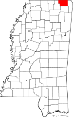
Alcorn County, Mississippi Basics:


Alcorn County Mississippi - Government Site

Population: 37,228
Area: 400 square miles
County seat: Corinth
Area code(s) in use: 662
Time zone: CST
High school graduate or higher: 78.6%
Bachelor's degree or higher: 17.1%
Median household income: $32,846
Persons in poverty: 19.4%
Home ownership rate: 70.0%
Mean travel time to work: 20.9 minutes


Adjacent counties:
Hardeman (TN)  Hardin (TN)  McNairy (TN)  Prentiss  Tippah  Tishomingo  
Find in Mississippi

Map of the Alcorn County area


Our detail map of Alcorn County shows the Alcorn County, Mississippi boundary lines and other interesting items.

Places in Alcorn County, Mississippi

  Airports     show all on map

Roscoe Turner Airport

  Areas     show all on map

Black Belt

  Bridges     show all on map

Box Bridge (historical), Butler Bridge, Crum Bridge, Irby Bridge (historical), Lookout Bridge, Polk Levee Bridge, Smith Bridge, Turnpike Bridge, Youngs Bridge (historical)

  Buildings     show all on map

Alcorn County Courthouse, Alcorn County Regional Correctional Facility, Biggersville Volunteer Fire Department, Corinth Arsenal (historical), Corinth City Hall, Corinth Fire Department Station 1, Corinth Fire Department Station 2, Corinth Fire Department Station 3, Corinth Fire Department Station 4, Corinth Public Library, Curlee Museum, Farmington Fire and Rescue, Floyds Store (historical), Glen Volunteer Fire Department, Henderson Store (historical), Jacinto Volunteer Fire Department, Kossuth Volunteer Fire Department, Mathis Store (historical), Northeast Mississippi Museum, Rienzi Volunteer Fire Department, Routen Store (historical), Southwest Volunteer Fire Department, Union Center Theo Volunteer Fire Department

  Canals     show all on map

Sevenmile Creek Drainage Ditch, Tuscumbia River Canal

  Cemeteries     show all on map

Alcorn Cemetery, Arbor Cemetery, Beoshear Cemetery, Bethlehem Cemetery, Clark Cemetery, Corinth City Cemetery, Corinth National Cemetery, Dilworth Cemeteries, Dilworth Cemetery, Forest Hill Cemetery, Forrest Memorial Park, Gray Cemetery, Greenhaw Cemetery, Hardwick Cemetery, Henry Cemetery, Jacinto Cemetery, Johns Cemetery, Kemp Chapel Cemetery, Lebanon Cemetery, Malone Cemetery, Marvin Cemetery, McWilliams Cemetery, Mount Pleasant Cemetery, New Hope Cemetery, Old Danville Cemetery, Old Mount Carmel Cemetery, Overton Cemetery, Palmer Cemetery, Piney Grove Cemetery, Pleasant Grove Cemetery, Pleasant Ridge Cemetery, Rienzi Cemetery, Rienzi Cemetery, Stockade Cemetery, Timmons Cemetery, Tuscumbia Cemetery, Tuscumbias Grave, Union Cemetery, Wheeler Cemetery, Williams Cemetery, Williams Cemetery, Wilson Cemetery, Wyly Cemetery

  Churches     show all on map

Alcorn Church, Alcorn Missionary Baptist Church, Antioch Church, Antioch Church, Antioch Church Number 1, Antioch Church Number 2, Bethel United Methodist Church, Bethlehem Baptist Church, Biggersville Church, Biggersville First Baptist Church, Box Chapel Methodist Church, Brush Creek Baptist Church, Calvary Baptist Church, Calvary Pentecostal Church, Church of Christ, City Road Temple Christian Methodist Episcopal Church, Clear Creek Church, County Line Baptist Church, Danville Church, East Corinth Baptist Church, East Corinth Church of Christ, East Fifth Street Missionary Baptist Church, Ebenezer Methodist Church, Elbethel Church (historical), Farmington Baptist Church, Fillmore Street Presbyterian Church (historical), First Assembly of God Church, First Baptist Church, First Pentecostal Church, First Presbyterian Church, First United Methodist Church, Foote Street Church of Christ, Fraleys Chapel Church of Christ, Friendship Church, Gaines Chapel United Methodist Church, Glendale Baptist Church, Gospel Tabernacle, Harmony Church (historical), Hatchie Chapel, Hinkle Creek Baptist Church, Holly Baptist Church, Hopewell Methodist Church, Hopwell Missionary Baptist Church, Indian Springs Church, Jerusalem Church, King Street African Methodist Episcopal Church (historical), Kossuth Missionary Baptist Church, Kossuth United Methodist Church, Lakeview Missionary Baptist Church, Lebanon Methodist Church (historical), Liberty Hill Church, Lick Branch Church, Little Zion Missionary Baptist Church, Lone Oak Church, Lovejoy Church, Macedonia Church, Macedonia Missionary Baptist Church, Marvin Church (historical), Mays Creek Church (historical), Meiggs Street Church of Christ, Mills Chapel (historical), Mills Community Church, Mount Carmel Methodist Church, Mount Moriah Methodist Episcopal Church, Mount Pleasant Church, New Hope Church, New Hope Church, New Prospect Church, North Corinth Baptist Church, North Rienzi Church of Christ, Oak Grove Church, Oak Hill Church, Oak Hill Church, Oakland Baptist Church, Old Danville Church, Overton Hill Church, Pine View Church, Pinecrest Baptist Church, Pleasant Hill Church, Pleasant Hill United Methodist Church, Pleasant Ridge Church, Pleasant Ridge Church (historical), Plesant Grove Church (historical), Rienzi Baptist Church, Rienzi Church of Christ, Rienzi Methodist Church, Rock Hill Church, Saint James Catholic Church, Saint Luke Church, Saint Lukes Church, Saint Mark Baptist Church, Saint Pauls Episcopal Church, Saint Rest Missionary Baptist Church, Salem Church, Sardis Primitive Baptist Church, Second Pentecostal Church (historical), Shady Grove Church, Shady Grove Church (historical), Shady Grove Methodist Church, Shady Grove Mission, Shiloh Baptist Church, Shiloh Church, South Corinth Baptist Church, Southside Methodist Church, Synagogue Missionary Baptist Church, Tate Street Baptist Church, Taylor Chapel (historical), Theo Church, Tishomingo Chapel Baptist Church, Trinity Methodist Church, Tuscumbia Baptist Church, Union Baptist Church, Waldron Street Christian Church, Welcome Church, Wenasoga Church of Christ, Wesley Chapel Methodist Church, West Corinth Baptist Church, West Corinth Church of Christ, West Corinth Pentecostal Church, Wheeler Grove Baptist Church

  Dams     show all on map

Benjimen Lake Dam, Bumpus Lake Dam, Crum Lake Dam, Houston Farris Pond Dam, Howard Little Pond Dam, J E Powell Pond Dam, Jones Lake Dam, Little Lake Dam, Mitchell Lake Dam, Moss Lake Dam, Mrs Curtis Brawner Pond Dam, Tuscumbia Watershed Structure 24 Dam, Tuscumbia Watershed Structure 8 Dam, Wilbanks Lake Dam

  Hospitals     show all on map

Alcorn County Health Center, Community Hospital (historical), Corinth Sanitarium (historical), Magnolia Regional Health Center

  Lakes     show all on map

Buffalo Hole, Jobes Lake, Jobes Lake, Long Pond, Santa Fe Lake

  Locales     show all on map

Alcorn (historical), Anderson (historical), Antioch (historical), Boneyard (historical), Camp Warriner, Coke Spur, Corinth Industrial Park, Danville (historical), Dilworth Store (historical), Farmer (historical), Hillandale Country Club, Hinkle (historical), Jones Mill (historical), Mingo City (historical), Nabors (historical), Old Rinezi (historical), Overton (historical), Potts Store (historical), Whitfield Plantation (historical)

  Military     show all on map

Battery A (historical), Battery B (historical), Battery C (historical), Battery D (historical), Battery Dillon (historical), Battery E (historical), Battery F (historical), Battery Lathrop (historical), Battery Madison (historical), Battery Phillips (historical), Battery Power (historical), Battery Robinett (historical), Battery Tannrath (historical), Battery Williams (historical)

  Parks     show all on map

Corinth City Park, Johns Street Park

  Populated Places     show all on map

Allentown, Biggersville, Collins Crossing, Collinstown, Corinth, Crow, Crumtown, Cuba, Farmington, Gift, Glens, Hightown, Indian Springs, Jacinto, Jobes, Jonestown, Kendrick, Kossuth, Lone Pine, Rienzi, Ross Crossing, Ruslor Junction, Searcy Town, Strickland, Synagogue, Theo, Wenasoga, West Corinth

  Post Offices     show all on map

Glen Post Office, Mitchells Store Post Office (historical)

  Reservoirs     show all on map

Burns Lake, Dees Pond, Epps Lake, Hillandale Lake, Hughes Pond, Liddon Lake, Millers Pond, Mitchel Lake, Seven Springs Lake, Surratt Pond, Waukomis Lake, Weedon Lake

  Ridges     show all on map

Bennett Ridge, Browder Ridge, Elam Ridge, Hatchie Hills, Winbush Ridge

  Schools     show all on map

Alcorn Central Elementary School, Alcorn Central High School, Alcorn County Vocational Center, Anyola School (historical), Bell School, Bethel School (historical), Biggersville Elementary School, Biggersville High School, Boneyard School (historical), Brush Creek School (historical), Brush School, Carpenter School (historical), Clear Creek School (historical), Concord School, Corinth Female College (historical), Corinth Junior-Senior High School, Corona Female College (historical), Crow School (historical), Crum School (historical), Deerlick School, Dennistown School, Dilworth School (historical), Dixon School (historical), East Corinth Elementary School, Elbethel School (historical), Eula School (historical), Farmington Academy (historical), Farmington School, Field School (historical), Gift School, Glendale School, Griffin School (historical), Gwyna School, Hickory Flat School, Hinkle School, Hinton School (historical), Holly School, Honno Two School (historical), Hopewell School (historical), Jacinto Male Academy (historical), Jacinto School (historical), Juliett School (historical), Kossuth Elementary School, Kossuth High School, Layton School (historical), Liberty Hill School (historical), Little Zion School, Lookout School, Madden School (historical), Marvin School (historical), Mathis School, Mattox School (historical), McGlathery School, Melvin School (historical), Moccasin School (historical), Oak Grove School, Oak Hill Christian School (historical), Oakland School, Palmichie School, Pleasant Hill School (historical), Price Academy (historical), Progress School (historical), Purdy Road School, Rienzi Academy (historical), Rienzi Elementary School, Rienzi High School (historical), Rienzi Public School (historical), Rosenwald School (historical), Scsally School (historical), Shadmon School (historical), South Corinth Elementary School, Sumner School, Synagogue-Dilworth School (historical), Tuscumbia School (historical), Union Center School, Union Elementary School, Union School (historical), W I Gibson College (historical), Walker School (historical), Wayside School (historical), West Corinth Elementary School, Zion School (historical)

  Springs     show all on map

Poplar Spring, Waukomis Spring, Whitehurst Spring

  Streams     show all on map

Babb Branch, Bain Creek, Beaverdam Creek, Bell Branch, Boone Creek, Brice Branch, Bridge Creek, Bridge Creek, Browder Branch, Brush Creek, Bucks Branch, Bynum Creek, Cadle Creek, Cane Creek, Casin Creek, Childers Branch, Choate Creek, Clear Creek, Cody Creek, Coon Creek, Cooney Creek, Dixon Creek, Dry Creek, Eastes Creek, Elam Creek, Elliott Creek, Essley Branch, Fourth Creek, Goose Pond Creek, Greenhaw Branch, Harper Branch, Harville Branch, Herman Creek, Hines Branch, Hinkle Creek, Holly Branch, Hughes Branch, Hurricane Creek, Hurricane Creek, Jobes Creek, Keaths Creek, Kemp Branch, Kossuth Creek, Lambert Branch, Lampkin Branch, Lick Branch, Little Brush Creek, Little Cane Creek, Little Clear Creek, Maness Branch, Marlar Creek, Mason Creek, Mathis Creek, Mays Creek, McDougal Creek, McElroy Creek, Mills Creek, Moores Creek, Nichols Branch, Old Danville Creek, Parmicha Creek, Phillips Creek, Pittman Branch, Railroad Branch, Reedy Branch, Rider Creek, Rinehart Branch, Robinson Creek, Searcy Branch, Silver Springs Creek, Slab Branch, Strickland Branch, Tarebreeches Creek, Taylor Creek, Tick Creek, Turner Creek, Underwood Creek, Wallace Branch, Wardlow Creek, Whitehurst Branch, Yellow Jacket Creek

  Summits     show all on map

Antioch Hill, Bald Hill, Bloodsaw Hill, Bragg Mountain, College Hill, Crow Mountain, Crum Mountain, Gobblers Knob, Hancock Hill, Kimmons Hill, Michales Hill, Pine Mountain, Rogers Hill, Sand Hill, Southerland Hill, Williams Graveyard Hill

  Towers     show all on map

Glen Lookout Tower, Pine Mountain Lookout Tower

  Valleys     show all on map

Jones Hollow, Kellum Hollow, Lewis Hollow, Nancy Hollow, Sorghum Hollow, Springer Glade, Transfer Hollow, White Oak Hollow,

Alcorn County, Mississippi Population By Race (2012 estimate)

RacePopulation
WhiteAlcorn County White population 32,12832,127  
BlackAlcorn County Black population 4,5054,504
MixedAlcorn County Mixed population 335335
AsianAlcorn County Asian population 149148
American IndianAlcorn County American Indian population 112111
Hawaiian & Pacific IslanderAlcorn County Hawaiian & Pacific Islander population 00

Additional population tables :
State population table
Mississippi population by county