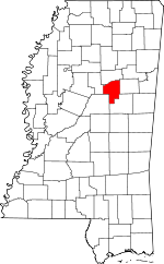
Choctaw County, Mississippi Basics:
Choctaw County Mississippi - Government Site
Population: 8,333
Area: 418 square miles
County seat: Ackerman
Area code(s) in use: 662
Time zone: CST
High school graduate or higher: 79.3%
Bachelor's degree or higher: 12.5%
Median household income: $30,180
Persons in poverty: 21.9%
Home ownership rate: 74.3%
Mean travel time to work: 27.1 minutes
Adjacent counties:
Attala Montgomery Oktibbeha Webster Winston
Places in Choctaw County, Mississippi
Ackerman Choctaw County Airport Ackerman Volunteer Fire Department,
Bywy Volunteer Fire Department,
Chester Volunteer Fire Department,
Choctaw Work Center,
French Camp Volunteer Fire Department,
Reform Volunteer Fire Department,
Simpson Volunteer Fire Department,
Weir Volunteer Fire Department Big Black River Canal,
Big Bywy Ditch,
Short Canal Antiocho Cemetery,
Ballard Cemetery,
Bankston Cemetery,
Bethel Cemetery,
Bethlehem Cemetery,
Bethlehem Cemetery,
Bethsalem Cemetery,
Bethsalem Cemetery,
Beulah Cemetery,
Big Jerusalem Cemetery,
Bluff Spring Cemetery,
Blythe Creek Cemetery,
Bowles Cemetery,
Cathledge Cemetery,
Chapel Hill Cemetery,
Chester Cemetery,
Clear Springs Cemetery, Cox Cemetery,
Crape Creek Cemetery, Curtis Cemetery,
Dacus Cemetery, Dobbs Cemetery, Downing Cemetery,
Ebenezer Cemetery,
Enon Cemetery,
Fellowship Cemetery,
Fentress Cemetery,
Freewill Cemetery,
French Camp Cemetery,
Hamrick Cemetery,
Head Cemetery, Hebron Cemetery,
Hemphill Cemetery,
Hopewell Cemetery,
Hopewell Cemetery, Jarod Cemetery, Jayroe Cemetery,
Jenkins Cemetery,
La Grange Cemetery,
Lebanon Cemetery, Little Shaw Cemetery, Love Cemetery, Luddock Cemetery,
Macedonia Cemetery, Malone Cemetery,
McCurtin Creek Cemetery,
Mill Springs Cemetery, Morrison Cemetery, Moss Cemetery,
Mount Airy Cemetery,
Mount Moriah Cemetery,
Mount Pisgah Cemetery,
Mount Zion Cemetery, Mullens Cemetery,
Nebo Cemetery,
New Haven Cemetery,
New Zion Cemetery,
Old Antioch Cemetery,
Old Concord Cemetery,
Old Mount Pisgah Cemetery, Old Salem Cemetery,
Owens Chapel Cemetery,
Penderville Cemetery, Pigeon Roost Cemetery,
Pilgrims Rest Cemetery,
Pisgah Cemetery,
Providence Cemetery, Rosemond Cemetery,
Salem Cemetery,
Salem Cemetery, Shiloh Cemetery, Simpson Cemetery,
South Union Cemetery,
Spring Hill Cemetery, Staples Cemetery,
Tanksley Cemetery,
Thompson Cemetery, Trussell Cemetery,
Turner Cemetery,
Weir Cemetery,
Weir Chapel Cemetery,
Wood Cemetery,
Wood Springs Cemetery Ackerman Baptist Church,
Ackerman Church of Christ,
Ackerman United Methodist Church,
Antioch Church,
Antioch Church (historical),
Bethany Church,
Bethel Church (historical),
Bethlehem Church,
Bethlehem Church,
Bethsalem Baptist Church,
Bethsalem Church,
Beulah Baptist Church,
Big Jerusalem Missionary Baptist Church,
Bluff Chapel,
Bluff Spring Church,
Blytha Creek Church,
Bywy Church,
Chapel Hill Church,
Chester Baptist Church,
Church of God,
Church of God,
Clear Springs Church,
Concord Church,
Crape Creek Church,
Crossroads Church,
Ebenezer Church,
Enon Presbyterian Church,
Epworth Church,
Fellowship Church,
Freewill Church,
Gospel Temple Church of God in Christ,
Hopewell Church,
Hopewell Church,
La Grange Church,
Macedonia Primitive Baptist Church,
McCurtain Creek Church,
Millsprings Church,
Mount Airy Church,
Mount Moriah Church,
Mount Nebo Church,
Mount Nebo Church,
Mount Olive Church,
Mount Pisgah Baptist Church,
Mount Salem Baptist Church,
Mount Zion Church,
New Haven Church,
New Jerusalem Church (historical),
New Zion Church,
New Zion Church (historical),
Old Lebanon Church,
Old Mount Pisgah Church,
Owens Chapel,
Owens Chapel (historical),
Penderville Church,
Pilgrims Rest Church,
Pisgah Church,
Pleasant Valley Church (historical),
Providence Church,
Reform Chapel,
Robinson Chapel,
Rockport Church,
Rockport Church (historical),
Saint John Church (historical),
Salem Church,
Salem Church,
Shady Grove Church,
Sister Jerusalem Church,
South Union Church,
Springhill Church,
Ventlers Chapel (historical),
Wood Springs Church Alex Faulkner Lake Dam,
Aubry Epps Lake Dam,
Booth Lake Dam,
Brooks Lake Dam,
Burdine Lake Dam,
C E King Lake Dam,
Charlie Ray Lake Dam,
Choctaw Lake Dam,
Doss Lake Dam,
E L Sherdan Pond Dam,
Hunting Club Lake Dam,
K T Barnett Lake Dam,
Opel Blane Lake Dam,
Roland Lake Dam,
Upper Yockanookany Number 1 Dam,
Upper Yockanookany Number 2 Dam,
Upper Yockanookany Number 3 Dam,
Upper Yockanookany Number 4 Dam,
Weir Lagoon Dam,
Whitehead Lake Dam Blantons Gap Choctaw County Medical Center Hospital Ada (historical),
Bankston (historical),
Blackwell (historical),
Blaine Store (historical),
Bywy Overlook,
Cannon (historical),
Choctaw Lake Campground Recreation Site,
Choctaw Lake Campground Recreation Site,
Coxs Store (historical),
Dido (historical),
Dranes Mills (historical),
Grahamsville (historical),
Irvin Spur (historical),
Kenago (historical),
La Grange (historical),
New Prospect (historical),
Pensacola (historical),
Pigeon Roost (historical),
Pinto (historical),
Robinsons Store (historical),
Simpson Store (historical),
Springfield (historical),
Theresa (historical),
Tombigbee District Ranger Station,
Watsons Mill (historical),
Watsons Store (historical),
White Mill (historical),
Wilcox (historical) Choctaw Lake Recreation Area,
Jeff Busby Park Ackerman,
Bywy,
Chester,
Fentress,
French Camp,
Fulcher,
Kerr,
Reform,
Sherwood,
Tollison,
Tomnolen,
Tuscan,
Weir,
Williams,
Wood Springs Bankston Post Office (historical), Dido Post Office (historical), Fulcher Post Office (historical), Reform Post Office (historical)
Choctaw Lake Ackerman Attendance Center,
Ackerman Elementary School,
Ashfordville School (historical),
Atkins School (historical),
Baker School (historical),
Bankston School (historical),
Berry Thomas School (historical),
Bluff Springs School (historical),
Boyd School (historical),
Busby School (historical),
Bywy School (historical),
Center Ridge School (historical),
Centerville School (historical), Central Mississippi Institute (historical),
Chapel Hill School (historical),
Choctaw County Vocational Technical School,
Cork Colored School (historical),
Cork School (historical),
County Line School (historical),
Downing School (historical),
Dry Creek School (historical),
Ebenezer School (historical),
Fair School (historical),
Fairview School (historical), French Camp Academy (historical),
French Camp Elementary School,
Grange Hall School (historical),
Head School (historical),
Hebron School (historical),
Hobson School (historical),
Hogan Chapel School (historical),
Hutchinson School (historical),
Jackson School (historical),
Jenkinsville School (historical),
Kennedy School (historical),
Killough School (historical),
Malloxville School (historical),
Miller School (historical),
Mount Airy School (historical),
Myatt Creek School (historical),
Noxubee Grange Hall School (historical),
Pilgrims Rest School (historical),
Pine Bluff School (historical),
Pine Grove School (historical),
Progress School (historical),
Prospect School (historical),
Providence School (historical),
Reform Consolidated School (historical),
Robinson Chapel School (historical),
Simpson School (historical),
Spay School (historical),
Steadman School (historical),
Sycamore School (historical),
Union School (historical),
Vowell School (historical),
Weir Attendance Center,
Weir Elementary School Lignite Spring,
Williams Spring Ballard Branch,
Baptism Branch,
Bay Branch,
Besa Chitto Creek,
Big John Branch,
Blytha Creek,
Boatman Branch,
Boatner Branch,
Bowie Branch,
Box Branch,
Boyd Creek,
Briar Creek,
Bywy Creek,
Cummings Branch,
Curtis Branch,
Daniels Creek,
Downing Branch,
Dry Creek,
Dudley Branch,
Ebenezer Branch,
Egg Creek,
Elkins Creek,
Furcher Branch,
Hamrick Creek,
Hester Branch,
Horse Branch,
Hurricane Creek,
Irvin Branch,
Jenkins Branch,
Jenkins Creek,
King Branch,
King Creek,
Little Bywy Creek,
Log Branch,
Marshall Branch,
Middle Bywy Creek,
Mike Creek,
Mile Branch,
Moore Branch,
Mossy Branch,
Mud Branch,
Murphy Branch,
Phillips Creek,
Pigeon Roost Creek,
Rawhide Branch,
Reedy Branch,
Reedy Creek,
Rhiner Creek,
Robinson Branch,
Salt Creek,
Sheedy Branch,
Sheffield Creek,
Spring Branch,
Stewart Creek,
Tanyard Branch,
Wildcat Creek,
Winters Branch Ironstone Hills,
Little Mountain,
Lolly Hill,
Noxubee Hills Choctaw Lookout Tower,
Weir Lookout Tower,
WEXA-FM (Eupora),
WMAB-TV Tower (Saint Louis),

