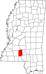
Lawrence County, Mississippi Basics:


Lawrence County Mississippi - Government Site

Population: 12,557
Area: 431 square miles
County seat: Monticello
Area code(s) in use: 601
Time zone: CST
High school graduate or higher: 81.8%
Bachelor's degree or higher: 13.3%
Median household income: $38,364
Persons in poverty: 18.7%
Home ownership rate: 80.1%
Mean travel time to work: 34.6 minutes


Adjacent counties:
Copiah  Jefferson Davis  Lincoln  Marion  Pike  Simpson  Walthall  
Find in Mississippi

Map of the Lawrence County area


Our detail map of Lawrence County shows the Lawrence County, Mississippi boundary lines and other interesting items.

Places in Lawrence County, Mississippi

  Airports     show all on map

Clay Airport

  Buildings     show all on map

Arm Volunteer Fire Department, Center Fire Department, Monticello Fire Department, New Hebron Volunteer Fire Department, North Pleasant Hill Fire Department, Oakvale Fire Department, Oma Fire Department, Silver Creek Fire and Rescue, Sontag Fire Department, Tilton Fire Department, Topeka Fire Department, Wanilla Fire Department

  Cemeteries     show all on map

Armstrong Cemetery, Benson Cemetery, Bozeman Cemetery, Buckey Cemetery, Cliburn Cemetery, Dampeer Cemetery, Droummonds Cemetery, Fair Hill Cemetery, Hepzibah Cemetery, North Pleasant Hill Cemetery, Sauls Cemetery, Sauls Valley Cemetery, Scarber Cemetery, Sills Cemetery, Smith Cemetery, Stephens Cemetery, Stringer Cemetery, Wilson Cemetery

  Churches     show all on map

Antioch Church, Bahala Chapel, Ballards Chapel, Bethany Church, Bethel Church, Bethel Church, Canaan Church, Carmel Church, Chinalee Church, Church of Christ, Church of God, Church of God, Cole Church, Crooked Creek Church, Fair Hill Church, First Assembly of God Church, Forest Grove Church, Friendship Church, Hepzibah Church, Jayess Baptist Church, Monticello Baptist Church, Monticello First Baptist Church, Monticello United Methodist Church, Mount Pleasant Church, Mount Zion Church, Mount Zion Church, New Hope Baptist Church, New Zion Church, North Pleasant Hill Church, Oak Grove Church, Oak Grove Missionary Baptist Church, Old Silver Creek Church, Pearl River Valley Church, Pin Oak Church, Pine Grove United Pentecostal Church, Pleasant Grove Baptist Church, Powells Grove Church, Providence Church, Riverside Baptist Church, Rock Hill Church, Rocky Branch Baptist Church, Rose Hill Church, Saint James Church, Saint Paul Church, Salem Church, Sauls Valley Church, Shiloh Baptist Church, Southgate Baptist Church, Spring Hill Church, Unity Church

  Crossings     show all on map

Pines Ferry (historical)

  Dams     show all on map

Ballard Pond Dam, Fortenberry Pond Dam, Mary Crawford Lake Dam, Saint Regis Paper Holding Reservoir, Saint Regis Pond Dam, Saint Regis Pond Dam, Saint Regis Pond Dam, Sasser Pond Dam, Wilson Lake Dam

  Hospitals     show all on map

Lawrence County Hospital

  Lakes     show all on map

Cammack-Young Lake, Sutton Lake, Wilsons Lake

  Locales     show all on map

Commons Store (historical), Divide, Grange, Sheppards Store (historical)

  Populated Places     show all on map

Arm, Bristers Store, Ferguson, Hardscrabble (historical), Hooker, Jayess, Lamberts Store, Monticello, New Hebron, Nola, Oak Vale, Oma, Robinwood, Rosella, Silver Creek, Sontag, Tilton, Topeka, Tryus, Verna, Wanilla

  Post Offices     show all on map

Arm Post Office (historical), Hooker Post Office (historical), Sontag Post Office, Topeka Post Office (historical), Tryus Post Office (historical)

  Reservoirs     show all on map

Lake Mary Crawford

  Schools     show all on map

Beulah Williams Elementary School, McCullough Junior High School, Monticello Elementary School, Monticello High School, New Hebron School, Silver Creek Attendance Center (historical), Topeka- Tilton School

  Springs     show all on map

Joseph Neylans Spring

  Streams     show all on map

Armstrong Branch, Bahala Creek, Bear Creek, Bear Creek, Bird Branch, Cascade Creek, Cliburn Branch, Coopers Creek, Crooked Creek, Crumps Creek, Dry Creek, Fair River, Germany Branch, Gibson Branch, Halls Creek, Hooker Hollow Creek, Hurricane Creek, Irving Creek, Johnson Branch, Kings Creek, Little Bahala Creek, Mallett Creek, Marshall Creek, Middle Prong Silver Creek, Mill Creek, Nim Branch, Old Spring Branch, Pretty Branch, Price Creek, Saddlebags Creek, Shaw Branch, Shop Branch, Silver Creek, Simon Creek, Swilley Branch, Tilton Creek, West Prong Silver Creek, White Sand Creek, Wiley Branch

  Summits     show all on map

Hope Hill

  Towers     show all on map

Tilton Lookout Tower, WMLC-AM (Monticello),

Lawrence County, Mississippi Population By Race (2012 estimate)

RacePopulation
WhiteLawrence County White population 8,5018,501  
BlackLawrence County Black population 3,8933,892
MixedLawrence County Mixed population 100100
American IndianLawrence County American Indian population 3837
Hawaiian & Pacific IslanderLawrence County Hawaiian & Pacific Islander population 00

Additional population tables :
State population table
Mississippi population by county