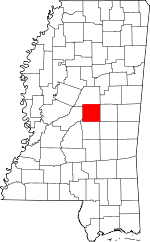
Leake County, Mississippi Basics:
Leake County Mississippi - Government Site
Population: 23,289
Area: 583 square miles
County seat: Carthage
Area code(s) in use: 601 662
Time zone: CST
High school graduate or higher: 74.0%
Bachelor's degree or higher: 10.5%
Median household income: $30,862
Persons in poverty: 26.9%
Home ownership rate: 75.8%
Mean travel time to work: 33.5 minutes
Adjacent counties:
Attala Madison Neshoba Newton Rankin Scott Winston
Places in Leake County, Mississippi
Carthage-Leake County Airport Lindsays Bridge (historical) Barnes Volunteer Fire Department,
Carthage Fire Depaerment,
Edinburg Volunteer Fire Department,
Leake County Correctional Facility,
Lena Volunteer Fire Department,
Madden Volunteer Fire Department,
Marydell Volunteer Fire Department,
Mississippi Forestry Commission Leake Fire Tower,
Ofahoma Volunteer Fire Department,
Reformation Volunteer Fire Department,
Thomastown Volunteer Fire Department,
Walnut Grove Correctional Facility,
Walnut Grove Volunteer Fire Department Addy Ann Cemetery,
Antioch Cemetery, Arthur Cemetery,
Atkins Cemetery, Atkins Cemetery, Baff Cemetery,
Barnett Memorial Garden, Beckham Cemetery, Beeman Cemetery,
Bethel Cemetery,
Bethel Cemetery,
Big Spring Cemetery, Blocker Cemetery,
Britt Cemetery,
Cedar Grove Cemetery, Collier Cemetery, Collier Cemetery, Conway Cemetery, County Line Cemetery, Cox Cemetery, Crawford Cemetery,
Damascus Cemetery, Delita Cemetery, Dew Cemetery,
Dorsey Cemetery, Dorsey Cemetery,
Dumas Cemetery (historical),
Ebenezer Cemetery,
Ebenezer Cemetery, Edwards Cemetery,
Forest Grove Cemetery,
Freeny Cemetery, Fryer Cemetery,
Fuston Cemetery,
Galilee Cemetery,
Good Hope Cemetery,
Goshen Cemetery, Graves Cemetery,
Gray Cemetery, Gray Cemetery,
Greenwood Cemetery,
Harmony Cemetery,
Harrell Cemetery, Harris Cemetery,
High Hill Cemetery,
Hopewell Cemetery, Hopewell Cemetery, Horne Cemetery,
Johnson Cemetery, Johnson Cemetery, Jordan Cemetery, Kemp Cemetery,
Leake Memorial Gardens,
Lena Cemetery, Liberty Cemetery,
Lindsey Cemetery,
Mars Hill Cemetery,
McDonald Cemetery, McGee Cemetery, Merthursday Cemetery,
Midway Cemetery, Moore Cemetery,
Mount Zion Cemetery,
Mount Zion Cemetery,
Nash Cemetery,
New Hope Cemetery,
New Providence Cemetery, Old Hebron Cemetery, Old Jerusalem Cemetery,
Parker Cemetery, Pensacola Cemetery, Phillips Cemetery, Pickens Cemetery,
Pilgrim Rest Cemetery,
Pilgrim Rest Cemetery,
Pleasant Grove Cemetery,
Pleasant Hill Cemetery, Poplar Spring Cemetery, Redwater Cemetery,
Reformation Cemetery,
Remus Cemetery, Rice Cemetery,
Rising Chapel Cemetery,
Robinson Cemetery,
Rock Hill Cemetery,
Rocky Point Cemetery,
Saint Ann Cemetery,
Salem Cemetery,
Salem Cemetery, Savel Cemetery,
Scott Cemetery, Scott Cemetery, Scott Cemetery,
Shackolo Cemetery,
Shields Cemetery, Simpson Cemetery,
Singleton Cemetery,
Springfield Cemetery,
Standing Pine Cemetery, Stevens Cemetery,
Stewart Cemetery,
Sunrise Cemetery,
Thomastown Baptist Cemetery,
Thomastown Christian Cemetery,
Tribulation Cemetery, Triplett Cemetery,
True Light Cemetery, Tucker Cemetery,
Turnage Cemetery, Turner Cemetery,
Wake Forest Cemetery,
Walnut Grove Cemetery, Ware Cemetery, Ware Cemetery, Weaver Cemetery, Wesley Chapel Cemetery, Williams Cemetery,
Wright Cemetery,
Zion Hill Cemetery,
Zion Hill Cemetery Redwater Census Designated Place,
Standing Pine Census Designated Place Antioch Church,
Bethel Church,
Bethel Church,
Bethlehem Church,
Big Springs Church, Carthage Cumberland Presbyterian Church,
Carthage Presbyterian Church,
Carthage United Methodist Church,
Cedar Grove Baptist Church,
Cedar Grove Church,
Center Hill Church,
Center Hill Church, Central Christian Church,
Cherry Chapel,
Christian Union Church,
Church of God in Christ, Conway Baptist Church, Conway Methodist Church,
Corinth Baptist Church,
Corinth Church,
County Line Baptist Church,
County Line Church,
Damascus Church,
Damascus Church (historical),
Delydia Hill Church,
Ebenezer Church,
Ebenezer Church (historical),
Faith Baptist Church,
First Baptist Church,
Forest Grove Church,
Free Mission Church,
Free Trade Church of God,
Freeny Baptist Church,
Freeny Methodist Church,
Galilee Church,
Galilee Church,
Galilee Missionary Baptist Church,
Good Hope Baptist Church,
Good Hope Church,
Good Hope Methodist Church,
Goshen Church,
Greenleaf Church,
Greenwood Church,
Harmony Church,
Holiness Church (historical),
Hope Well Church,
Johnson Chapel,
Johnson Chapel,
Jones Chapel,
Lena Baptist Church,
Lena Methodist Church,
Madden Baptist Church,
Madden Methodist Church,
Mars Hill Church,
Mary Bethel Church,
McDonald Church,
Midway Baptist Church,
Mount Bethel Church (historical), Mount Carmel Baptist Church,
Mount Charity Church,
Mount Harmon Church,
Mount Horeb Church (historical),
Mount Olive Church,
Mount Olive Church,
Mount Pleasant Church (historical),
Mount Zion Church,
Mount Zion Church,
Mount Zion Presbyterian Church (historical),
New Bethel Church,
New Ebenezer Church,
New Friendship Church,
New Home Church,
New Hope Baptist Church,
New Jerusalem Church,
New Prospect Church,
New Providence Church,
New Zion Church,
Old Arbor Mount Zion Church,
Old Jerusalem Church,
Pearl Hill Church,
Pilgrim Rest Church,
Pilgrim Rest Church (historical),
Pine Grove Church,
Pine Grove Church,
Pine Grove Church,
Pleasant Green Church,
Pleasant Grove Church,
Pleasant Hill Church,
Reformation Cumberland Presbyterian Church,
Remus Missionary Baptist Church,
Renfroe Baptist Church,
Renfroe Church,
Rising Chapel,
Rocky Point Church,
Saint Ann Catholic Church,
Salem Church,
Singleton United Methodist Church,
Springfield Church,
Standing Pine Church,
Sunrise Baptist Church,
Sunrise Church,
Sweetwater Church, Thomastown Baptist Church,
Thomastown Church, Thomastown Methodist Episcopal Church, Thomastown United Methodist Church,
Tribulation Church,
Trinity Baptist Church,
True Light Church,
Tuscola Missionary Baptist Church,
Union Ridge Church,
Wake Forest Church,
Walnut Grove Baptist Church,
Walnut Grove Cumberland Presbyterian Church,
Walnut Grove Methodist Church,
Wesley Chapel (historical),
Wiggins Baptist Church,
Wiggins Methodist Church,
Zion Church,
Zion Hill Church,
Zion Hill Primitive Baptist Church Yellow Bluff Bilbos Ferry (historical),
Boyds Ferry (historical),
Grigsbys Ferry (historical),
McFaddens Ferry (historical) Bilbro Lake Dam,
Carthage Sewage Lagoon Dam,
Coy Watkins Catfish Ponds Dam,
Grover Grimes Catfish Ponds Dam,
Indian Agency Lake Dam,
Indian Agency Pond Dam,
J E Upton Junior Catfish Pond Dam,
Jim Hudgins Pond Dam,
Kermit Daughterly Lake Dam,
McDonald Ponds Dam,
Molpus Lumber Company Lake Dam,
P B Dickens Catfish Ponds Dam,
R and R Farm Ponds Dam,
R and R Processing Plant Lagoon Dam,
Rance Johnston Catfish Pond Dam,
Smith Pond Dam,
Standing Pine Watershed Structure 5 Dam,
Standing Pine Watershed Structure 9 Dam,
Tom Bell Pond Dam,
W C Majors Pond Dam,
Willie Dumas Pond Dam Palmetto Flats Leake County Memorial Hospital Deal Island,
Peach Tree Island Adair Lake,
Alligator Lake,
Beaver Pond,
Black Lake,
Black Lake,
Boneyard Lake,
Brush Lake,
Clark Lake,
Coles Ford Lake,
Deep Lake,
Duck Pond Slough,
Dumas Pond,
Elbow Lake,
Flatwood Lake,
Gogg Lake,
Hanson Lake,
Hogpen Lake,
Horseshoe Lake,
Horseshoe Lake,
Joe Neal Lake,
Johnson Lake,
Jordan Lake,
Langston Lake,
Long Lake,
Perry Lake,
Popular Ridge Lake,
Round Lake Arnells Mill (historical),
Bennetts Store (historical),
Exley (historical),
Scrivner Poultry Farm,
Sproles (historical),
Sproles Siding,
Tuskala Mita (historical),
Watkins Store (historical),
Williamsburg (historical),
Yocanoocana (historical),
Zion (historical) Golden Memorial State Park,
Leake County Water Park,
McMillian Park,
Natchez Trace Parkway and National Scenic Trail Abdan,
Barnes,
Battle Bluff,
Bertice,
Bolatusha,
Carthage,
Conway,
Coosa,
Crossroad,
Dossville,
Dowell,
Drysdale,
Ebenezer,
Edinburg,
Estesmill,
Forest Grove,
Free Trade,
Freeny,
Gill,
Good Hope,
Goshen,
Gray, Green (historical),
Harmony,
High Hill,
Hopoca, Lameta (historical),
Lena,
Luther,
Madden,
Marydell,
McAfee,
Midway,
Ofahoma,
Pearl Hill,
Piggtown,
Pilgrim Rest,
Redwater,
Remus,
Renfroe,
Rosebud,
Saint Ann,
Salem,
Singleton,
Standing Pine,
Sunrise,
Thomastown,
Tuckers Crossing,
Tuscola,
Walnut Grove,
Wiggins,
Williston Conway Post Office (historical), Dossville Post Office (historical), Freeny Post Office (historical), Gray Post Office (historical), Hopoca Post Office (historical), Marydell Post Office (historical), Renfroe Post Office (historical), Tuscola Post Office (historical), Zion Post Office (historical)
Government Hills Barnes School (historical),
Bethel School (historical),
Big Springs School (historical),
Carthage Attendance Center,
Carthage Elementary School,
Carthage Female Academy (historical),
Carthage Junior High School,
Carthage Junior High School,
Cedar Grove School (historical),
Collier School (historical),
County Line School (historical),
Dossville School (historical),
Ealy School (historical),
Edinburg Attendance Center,
Edinburg High School,
Edinburg School (historical), Freeny High School (historical),
Good Hope Academy (historical),
Good Hope School (historical),
Goshen School (historical),
Harmony School, High Hill School (historical),
Leake Academy, Leake County Agricultural High School (historical),
Madden High School,
Pearl Hill School (historical),
Pilgrim Rest School (historical),
Pleasant Hill School (historical),
Reformation School (historical),
Remus School (historical),
Renfroe School (historical),
Rocky Point School (historical),
Salem School (historical), Shoofly School (historical),
Singleton School (historical),
South Leake School,
Standing Pine School,
Thomastown Attendance Center,
Thomastown Attendance Center,
Tuscola School (historical),
Wesley Chapel School (historical) Babb Branch,
Bain Creek,
Balucta Creek,
Battle Branch,
Beckham Branch,
Bell Branch,
Bibalucta Creek,
Blailock Creek,
Bose Nukse Creek,
Cobbs Creek,
Coleman Creek,
Colombo Creek,
Coon Creek,
Creal Field Branch,
Crookedwood Branch,
Crowder Creek,
Dry Branch,
Fisher Creek,
Gibbs Creek,
Good Hope Branch,
Goshen Branch,
Gravel Slough,
Gray Lake,
Harper Branch,
Harrell Branch,
Hill Branch,
Hinds Creek,
Hooper Mill Creek,
Horne Branch,
Hurricane Creek,
Indian Branch,
Josh Branch,
Kenty Creek,
Key Branch,
Lake Creek,
Landrum Creek,
Leake Creek,
Lee Lake,
Lobutcha Creek,
Mayo Branch,
Merchant Creek,
Mill Branch,
Mullens Branch,
Myers Branch,
Myric Creek,
Ninemile Creek,
Parker Branch,
Pellaphalia Creek,
Pellaphalia Creek,
Pickins Creek,
Pole Bridge Branch,
Pollard Creek,
Pottock Creek,
Redwater Creek,
Rice Creek,
Shaui Koli Creek,
Shiola Creek,
Simmons Creek,
Smith Creek,
Socki Creek,
Standing Cypress Creek,
Standing Pine Creek,
Sweetwater Creek,
Town Creek,
Tuscolameta Creek,
Watson Branch,
Witt Creek,
Yellow Creek,
Yockanookany River Bully Bayou WECP-AM (Carthage),
WWYN-FM (Carthage),

