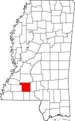
Lincoln County, Mississippi Basics:


Lincoln County Mississippi - Government Site

Population: 34,896
Area: 586 square miles
County seat: Brookhaven
Area code(s) in use: 601
Time zone: CST
High school graduate or higher: 81.0%
Bachelor's degree or higher: 16.5%
Median household income: $37,176
Persons in poverty: 21.6%
Home ownership rate: 76.8%
Mean travel time to work: 28.4 minutes


Adjacent counties:
Amite  Copiah  Franklin  Jefferson  Lawrence  Pike  Walthall  
Find in Mississippi

Map of the Lincoln County area


Our detail map of Lincoln County shows the Lincoln County, Mississippi boundary lines and other interesting items.

Places in Lincoln County, Mississippi

  Airports     show all on map

Brookhaven-Lincoln County Airport, Hoppy Field, Shadycreek Acres Airport

  Buildings     show all on map

Bogue Chitto Volunteer Fire Department, Brookhaven Fire Department Station 1 Central, Brookhaven Fire Department Station 2, Brookhaven Fire Department Station 3 Headquarters, East Lincoln Volunteer Fire Department, Heuck's Retreat Community Volunteer Fire Department, Hog Chain Volunteer Fire Department, Lincoln County Courthouse, Loyd Star Volunteer Fire Department, Mallalieu Pumping Station, New Sight Volunteer Fire Department, Ruth Volunteer Fire Department, Zetus Volunteer Fire Department

  Cemeteries     show all on map

Ben Salem Cemetery, Brister Cemetery, Brister Cemetery, Brookhaven Memorial Gardens, Burns Cemetery, Calcote Cemetery, Dickerson Cemetery, Dunn Cemetery, Easthaven Cemetery, Godman Cemetery, Kees Cemetery, Little Bahala Cemetery, Little Memorial Cemetery, Macedonia Cemetery, Macedonia Cemetery, McDavid Cemetery, Missionary Cemetery, Moak, Moak Cemetery, Montgomery Cemetery, Mount Zion Cemetery, New Sight Cemetery, Newell Cemetery, Philadelphia Cemetery, Pleasant Grove Cemetery, Pleasant Grove Cemetery, Price Cemetery, Price Cemetery, Rawls Cemetery, Rawls Cemetery, Rose Hill Cemetery, Ruth Cemetery, Saint John Cemetery, Smith Cemetery, Smith Cemetery, Stewarts Cemetery, Thompson Cemetery, Warren Cemetery, Zion Hill Cemetery

  Census     show all on map

Bogue Chitto Census Designated Place

  Churches     show all on map

Abundant Life Christian Center, Adams Church, Adams Grove Church (historical), Antioch Church, Arlington Baptist Church, Avery Chapel African Methodist Episcopal Church, Bensalem Church (historical), Bethel African Methodist Episcopal Church, Bethel Church, Bethel Church, Bethel Church, Bethel Church, Bethel Temple Church, Big Springs Church, Bogue Chitto Baptist Church, Brookway Baptist Church, Brookway Church of Christ, Calvary Church, Center Street Church of Christ, Central Baptist Church, Central Church of Christ, Chisholm Mission, Clear Branch Church, Cold Springs Church, Corinth Church, Crump Church, Damascus Church, East Lincoln Baptist Church, Easthaven Baptist Church, Ebenezer Church, Emmanuel Temple Pentecostal Church, Episcopal Church of the Redeemer, Fair River Church, Faith Presbyterian Church, First Assembly of God Church, First Baptist Church, First Presbyterian Church, First United Methodist Church, First United Pentecostal Church, Friendship Church, Friendship Church, Greater Galilee Church, Greater Mount Olive Church, Greater Zion Chapel, Green Church, Greenwood Church, Gum Grove Church, Halbert Heights Baptist Church, Harmony Church, Hawkins Chapel, Heucks Retreat Baptist Church, Hillcrest Church, Holly Springs Church, Hopewell Church, Jackson Street United Methodist Church, Jericho Church, Johnson Grove Church, Kynette Pilgrim United Methodist Church, Lacks Chapel, Latter Day Saints Church, Little Bahala Church, Little Rock Church, Macedonia Church, Macedonia Church, Macedonia Church, Mallalieu Church, Mars Hill Church, Mathews Chapel, Mission Hill Church, Moaks Creek Church, Montgomery Church, Mount Carmel Church (historical), Mount Moriah Church, Mount Olive Church, Mount Pisgah Church, Mount Pleasant Church, Mount Salem Church, Mount Wade Baptist Church, Mount Zion Church, Mount Zion Church, Mount Zion Church, Mount Zion Church, New Hope Church, New Hope Church, New Hope Church, New Prospect Church, New Saint John Church, New Salem Church, New Sight Baptist Church, New Zion Union Church, Old Saint John Church, Palestine Church (historical), Pearlhaven Baptist Church, Philadelphia Baptist Church, Pilgrims Rest Church (historical), Pine Grove Church, Pleasant Grove Baptist Church, Pleasant Grove Church, Pleasant Grove Church, Pleasant Hill Church, Pleasant Ridge Church, Red Oak Grove Church, Rocky Bluff Church (historical), Rose Hill Church, Ruth Baptist Church, Ruth Church (historical), Saint Francis of Assisi Catholic Church, Saint James Baptist Church, Saint Mark Missionary Baptist Church, Saint Paul Baptist Church, Saint Paul Church, Second Baptist Church, Shady Grove Church, Siloam Church, Souls Harbor Church, Southway Baptist Church, Springfield Church, Thayer Church, Thompson Chapel, Topisaw Church, Topisaw Church, Union Baptist Church, Union Grove Church, Union Hall Baptist Church, Union Primitive Church, Wellman Baptist Church

  Crossings     show all on map

Interchange 24, Interchange 30, Interchange 38, Interchange 40, Interchange 42, Interchange 48

  Dams     show all on map

Bahala Creek Watershed Structure 1 Dam, Bahala Creek Watershed Structure 2 Dam, Bahala Creek Watershed Structure 3 Dam, Bahala Creek Watershed Structure 4 Dam, Bahala Creek Watershed Structure 5 Dam, Bes Arrington Lake Dam, Brookhaven Sewage Lagoon Dam, Burgess Lake Dam, C C Clarke Lake Dam, Chester Clarke Dam, Davis Lake Dam, Foster Lake Dam, Frank Hartman Lake Dam, Huecks Retreat Lake Dam, Hurricane Lake Dam, I O Smith Lake Dam, Lakewood Village Lake Dam, Lewis Mullens Lake Dam, Louie Entrican Lake Dam, Smith Lake Dam, Stradheim Lake Dam, Van Hatcher Lake Dam, Williams Lake Dam

  Hospitals     show all on map

Kings Daughters Medical Center, Lincoln County Health Center, Southwest Mississippi Mental Health Complex

  Locales     show all on map

Bahaloa (historical), Brents Mill (historical), Brookhaven Country Club, Brookhaven Shopping Village, Brookway Plaza Shopping Center, Case Mill (historical), Caseyville (historical), Cold Springs, Derby (historical), Fair River Store (historical), Haskins Saw Mill (historical), Heucks Retreat, Hog Chain (historical), Industrial Park Number 1, Industrial Park Number 2, Lincoln Plaza Shopping Center, Magees Mill (historical), Mayoville (historical), McCalls Creek Precinct (historical), McNair Mill (historical), Mississippi Central Junction, Old Malcum, Old Red Star, Shacks (historical), Soegaard (historical), Union Hall, Village Square Shopping Center, Westbrook Mart Shopping Center

  Oilfields     show all on map

Brookhaven Oil Field, Mallalieu Oil Field

  Parks     show all on map

Brookhaven City Park, Exchange Park

  Populated Places     show all on map

Arlington, Auburn, Blueberry Hill, Bogue Chitto, Bristerville, Brookhaven, Cam, Carlos, Caseyville, Center Point, Cobbs, East Lincoln, Enterprise, Fair Oak Springs, Fair River, Friendship, Harmony, Hartman, Loyd Star, Montgomery, New Sight, Norfield, Pearlhaven, Rafn, Ruth, Thayer, Vaughn, Wellman, West Lincoln, Wilkinson, Williams, Woolworth, Zetus

  Post Offices     show all on map

Carlos Post Office (historical), Caseyville Post Office (historical), Fair River Post Office (historical), Malcum Post Office (historical), Montgomery Post Office (historical), Redstar Post Office (historical), Ruth Post Office (historical), Wellman Post Office (historical), Zetus Post Office (historical)

  Reservoirs     show all on map

Clarks Lake, Gravel Pit Lake, Hurricane Lake, Smith Lake

  Schools     show all on map

Alexander High School, Arlington School (historical), Bailey Branch School (historical), Big Creek School (historical), Big Springs School (historical), Bogue Chitto Attendance Center, Brookhaven Academy, Brookhaven Elementary School, Brookhaven High School, Confederate Grove School (historical), East Lincoln Consolidated School (historical), Edwards School (historical), Enterprise School, Fair Oak Springs Consolidated School (historical), Fair River Hall School (historical), Friendship School (historical), Garner School (historical), Gills School (historical), Goodman School (historical), Grafton Hall School (historical), Grange Hall School (historical), Gum Grove School (historical), Harris High School, Hickory Grove School (historical), Huey School (historical), Kings School (historical), Lipsey Junior High School, Lloyd Hall School (historical), Lloyd Star Consolidated School, Love School (historical), Mamie L Martin Elementary School, Mullens School, Oak Grove School (historical), Oak Ridge School (historical), Ollie School (historical), Pine Grove School (historical), Pleasant Grove School (historical), Progress School (historical), R E Lee School (historical), Red Star School (historical), Reed School (historical), Ruth School, Saint Francis School, Searchlight School (historical), Sweetwater School (historical), Union Hall Academy (historical), West Lincoln Attendance Center, Whitworth College (historical)

  Streams     show all on map

Adam Creek, Allbritton Creek, Beaver Creek, Beaver Dam Creek, Big Creek, Blue Creek, Boone Creek, Butler Creek, Cedar Creek, Clear Branch, Clear Creek, Dickerson Creek, Doolittle Creek, Dry Creek, East Bogue Chitto, East Topisaw Creek, Fords Creek, Furr Branch, Gills Creek, Halbert Branch, Hog Branch, Isom Branch, Jackson Creek, Jordan Creek, Kees Creek, Lick Creek, Little Creek, Little Fair River, Meadville Branch, Moaks Creek, Mount Pleasant Creek, Myers Creek, Panter Creek, Perch Creek, Red Creek, Richey Creek, Sassers Mill Creek, Sawdust Branch, Shaws Creek, Taylors Creek, Turkey Branch, Walkers Creek, West Bogue Chitto

  Towers     show all on map

Heucks Lookout Tower, Lincoln Lookout Tower, Ruth Lookout Tower, WCHJ-AM (Brookhaven), WJMB-AM (Brookhaven), WMRQ-FM (Brookhaven),

Lincoln County, Mississippi Population By Race (2012 estimate)

RacePopulation
WhiteLincoln County White population 23,72923,729  
BlackLincoln County Black population 10,67810,678
MixedLincoln County Mixed population 279279
AsianLincoln County Asian population 105104
American IndianLincoln County American Indian population 7069
Hawaiian & Pacific IslanderLincoln County Hawaiian & Pacific Islander population 00

Additional population tables :
State population table
Mississippi population by county