Perry County, Mississippi Basics:


Perry County Mississippi - Government Site

Population: 12,095
Area: 647 square miles
County seat: New Augusta
Area code(s) in use: 601
Time zone: CST
High school graduate or higher: 80.2%
Bachelor's degree or higher: 7.4%
Median household income: $35,942
Persons in poverty: 20.5%
Home ownership rate: 86.3%
Mean travel time to work: 32.1 minutes

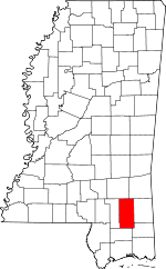
Adjacent counties:
Forrest  George  Greene  Jones  Stone  Wayne  

Find in Mississippi

Map of the Perry County area


Our detail map of Perry County shows the Perry County, Mississippi boundary lines and other interesting items.

Places in Perry County, Mississippi

  Airports     show all on map

Richton-Perry County Airport

  Bars     show all on map

Breakover Sandbar, Longfield Sandbar

  Bends     show all on map

Racetrack Bend, Scott Bend

  Bridges     show all on map

Bogue Homo Creek Mississippi Highway 42 Bridge, Gaines Brewer Road Bridge, Mahned Bridge, Tallahalla Creek Mississippi Highway 42 Bridge, Wingate Bridge

  Buildings     show all on map

Arlington Volunteer Fire Department, Beaumont Police Department, Beaumont Town Fire Department, Beaumont Volunteer Fire Department, Hintonville Volunteer Fire Department, Janice Volunteer Fire Department, Mississippi Forestry Commission Perry County Workstation, New Augusta Fire Department, New Augusta Police Department, New Augusta Volunteer Fire Department, New Augusta Volunteer Fire Department, Perry County Hospital Nursing Center, Perry County Sheriff's Department, Pine Forest Regional Library - Richton Public Library, Richton Police Department, Richton Volunteer Fire Department, Runnelstown Volunteer Fire Department Station 1 Headquarters, Runnelstown Volunteer Fire Department Station 2, United States Forest Service Fire Department

  Cemeteries     show all on map

Belton Cemetery, Breland Cemetery, Browns Cemetery, Burch Cemetery, Carter Hill Cemetery, Cochran Cemetery, Courtney Cemetery, Denham Cemetery, Edwards Cemetery, Fairley Cemetery, Fairley Cemetery, Ferguson Cemetery, Frisco Cemetery, Garraway Cemetery, Griffin Cemetery, Herring Cemetery, Hinton Cemetery, Hinton Cemetery, Hinton Cemetery, Hinton Cemetery, Hollimon Cemetery, Howard-Breland Cemetery, Isaiah Hinton Cemetery, James Cemetery, Lott Cemetery, McGilvary Cemetery, McKenzie Cemetery, McSwain Cemetery, McSwain Cemetery, Mixon Cemetery, New Augusta Cemetery, New York Cemetery, Nichols Cemetery, Prospect Cemetery, Riley Cemetery, Sims Cemetery, Stevens Cemetery, Sunset Cemetery, Sweetwater Cemetery, Sylvester Cemetery, Sylvester Cemetery, Taylor Cemetery, Thomas Cemetery, Wade Cemetery, Woodard Cemetery

  Churches     show all on map

Andrews Chapel, Arlington Baptist Church, Beaumont Church of God, Bethel Church, Bethel Church, Bethlehem Missionary Church, Bolton Chapel, Bolton Chapel United Methodist Church, Buck Creek Church, Calvary Church, Carter Hill Church, Clay Hill Church, Clear Creek Church, Corinth Church, County Line Church, Cross Roads Church, Cypress Creek Church, Dykes Chapel, Ebenezer Church, Fairhope Church, Fairhope Missionary Baptist Church, First Assembly of God Church, First Baptist Church, First United Pentecostal Church, Good Hope Church, Goodhope Baptist Church, Hickory Grove Church, Holiness Church, Holy Hill Church, House of Prayer Church, Indian Springs Baptist Church, Kittrell Church, Little Jerusalem Church, Mahned Church, Mars Hill Church, Memorial Church, Mount Zion Church, Nazareth Church, New Life in Christ Baptist Church, New Zion Church, Newhope Church, Oak Grove Church, Oak Grove Church, Pleasant Hill Church, Prospect Church, Providence Church, Richton First Baptist Church, Richton United Methodist Church, River Valley Church, River Valley Church, Runnelstown First Baptist Church, Saint John Church, Saint Luke Church, Saint Paul Baptist Church, Seminary Church, Sweet Pilgrim Church, Sweetwater Church (historical), Thompson Creek Church (historical), Union Church

  Cliffs     show all on map

Bland Bluff, Fairhope Bluff, Gin House Bluff, Reeds Bluff

  Crossings     show all on map

Gay Ford

  Dams     show all on map

B Conway Lake Dam, Carl Hollomans Pond Dam, Crane Lake Dam, D C Leach Lake Dam, Gandy Lake Dam, George Guthrie Pond Dam, James Grantham Pond Dam, Joe Blackmon Pond Dam, Lake Perry Dam, Larry Armstrong Lake Dam, Lawrence Armstrong Lake Dam, Mohlenoff Pond Dam, Perry Lake Dam, Scott Nicholson Catfish Ponds Dam, Sportsman Lake Dam, Tiak Dam, Vernon McDonnell Pond Dam

  Flats     show all on map

Buzzard Bay, Grantham Bay

  Forests     show all on map

DeSoto National Forest

  Hospitals     show all on map

Perry County General Hospital

  Islands     show all on map

Mossy Hammock

  Lakes     show all on map

American Legion Lake, Blue Lake, Breland Lake, Clear Lake, Crane Lake, Deitz Lake, Doctor Lake, Eddy Lake, Gandy Lake, Grantham Lake, Horseshoe Bend Lake, Izola Lake, Lott Dead River, McSwain Lake, Middle Lake, Moffett Lake, Palmetto Lake, Perry Lake, Round Lake, Rubin Lake

  Locales     show all on map

Biloxi Regional Sewer Treatment Plant West, Bogue Homo Creek Boat Ramp, Coopers Poultry Farm, Cypress Creek Landing, Davis KD Range, Erambert Seed Orchard, Fairley Bridge Landing, Fairly Bridge Landing, Lancaster (historical), Leaf River Boat Ramp, Meadows Mill (historical), Moodys Landing, Old Augusta, Old Augusta Boat Ramp, Paret Lot Work Center, Pauls Stumps, Ray Green Farm, Richs Mill (historical), Richton Publically Owned Treatment Works, Sweetwater, US Highway 98 Roadside Park, Water Valley Sewage Lagoon

  Parks     show all on map

Cypress Creek Landing Recreation Site, Fairley Bridge Landing Recreation Area, Janice Landing Recreation Site, Leaf River State Wildlife Management Area, Moodys Landing Recreation Area

  Populated Places     show all on map

Barbara, Batt Place, Beaumont, Belleville, Benmore, Brewer, Corinth, Deep Creek, East Side, Ferguson, Good Hope, Hercules Station, Hintonville, Indian Springs, Janice, Kittrell, Little Creek, Mahned, McSwain, New Augusta, Oak Grove, Progress, Redhill, Rhodes, Richton, Runnelstown, Tallahala, Wingate, Young Mobile Home Park

  Post Offices     show all on map

Richton Post Office

  Reserves     show all on map

Black Creek Wilderness

  Reservoirs     show all on map

Andrew Pond, Blue Pond, Crane Lake, Gator Hole Pond, Hollomans Pond, Inland Lakes, Lake Perry, McLeod Pond, Sportsman Lake

  Ridges     show all on map

Red Hills

  Schools     show all on map

Beaumont Elementary School, Beaumont High School, Bluff Creek School (historical), Brewer School (historical), Clay Hill School (historical), Deep Creek School (historical), Dykes School (historical), Janice School, Lower Line School (historical), New Augusta Elementary School, New York School (historical), Oak Grove School (historical), Perry Central High School, Red Hill School (historical), Richton Elementary School, Richton High School, Runnelstown Elementary School, Saint Johns School, Tucker Bay School (historical)

  Streams     show all on map

Allan Branch, Allan Branch, Ashley Creek, Bear Branch, Beaver Creek, Beaver Dam Creek, Beaver Pond Creek, Beaverdam Creek, Big Branch, Big Thick Branch, Black Branch, Blue Goose Branch, Bogue Homo, Buck Creek, Bug Branch, Burleman Branch, Burnt Rock Creek, Buzzard Branch, Calf Branch, Carter Branch, Carter Creek, Chapel Branch, Chatman Branch, Chattis Branch, Clear Creek, Coleman Creek, Crane Creek, Cypress Creek, Deep Creek, Denham Creek, Driving Branch, Dry Branch, East Prong Mill Creek, Fairchild Creek, Flat Branch, Flat Branch, Flat Branch, Flat Branch, Fox Branch, Frances Branch, Gaines Creek, Garraway Creek, Grantham Branch, Grapevine Branch, Griffin Spring Branch, Gum Branch, Hammock Branch, Harper Branch, Harverson Mill Creek, Hickory Creek, Hickory Flat Branch, Hood Branch, Howard Reed Brake, Hurricane Bay, Indian Branch, Joes Creek, Jumping Creek, Linda Creek, Little Creek, Long Branch, Long Branch, Long Branch, Long Branch, Long Branch, Lower Dead River, McLeod Branch, McSwain Branch, McWilliams Branch, Merritt Creek, Merritt Springs Branch, Middle Creek, Mike Branch, Miles Branch, Milky Creek, Mill Creek, Mill Creek, Mill Creek, Mill Creek, Mill Creek, Mossy Creek, Nicholson Branch, Oakwood Branch, Parker Branch, Pearces Creek, Pine Branch, Pine Log Branch, Pineland Branch, Piney Woods Creek, Pitts Branch, Pondy Branch, Ready Branch, Redhill Branch, Reedy Branch, Richland Creek, Sand Hill Creek, Sandy Run, Sapp Branch, Shut Eye Creek, Silver Run Branch, Stillhouse Branch, Sweetwater Creek, Sweetwater Creek, Tallahala Creek, Third Creek, Thomas Bay Branch, Thomas Branch, Thomas Creek, Thompson Creek, Toms Camp Branch, Turkey Branch, Underwood Branch, Walters Branch, Water Prong, Water Prong Creek, Weldy Creek, West Branch Hickory Creek, West Prong Mill Creek, Whiskey Creek, White Branch, White Pond Creek, Wolfpen Branch, Yellow Jacket Branch

  Summits     show all on map

Deadman Hill, Taylor Hill, Thompson Hill, Wolf Hill

  Swamps     show all on map

Spogett Bay

  Towers     show all on map

Beaumont Fire Tower, Leaf Lookout Tower, Paret Fire Tower, Richton Lookout Tower

  Trails     show all on map

Black Creek Hiking Trail

  Valleys     show all on map

Steep Hollow,

Perry County, Mississippi Population By Race (2012 estimate)

RacePopulation
WhitePerry County White population 9,4709,470  
BlackPerry County Black population 2,4312,431
MixedPerry County Mixed population 121120
American IndianPerry County American Indian population 3636
AsianPerry County Asian population 2424
Hawaiian & Pacific IslanderPerry County Hawaiian & Pacific Islander population 00

Additional population tables :
State population table
Mississippi population by county