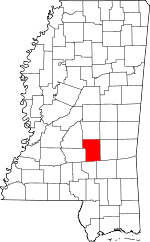
Smith County, Mississippi Basics:


Smith County Mississippi - Government Site

Population: 16,366
Area: 636 square miles
County seat: Raleigh
Area code(s) in use: 601
Time zone: CST
High school graduate or higher: 79.6%
Bachelor's degree or higher: 14.5%
Median household income: $36,519
Persons in poverty: 22.6%
Home ownership rate: 85.2%
Mean travel time to work: 29.6 minutes


Adjacent counties:
Covington  Jasper  Jones  Newton  Rankin  Scott  Simpson  
Find in Mississippi

Map of the Smith County area


Our detail map of Smith County shows the Smith County, Mississippi boundary lines and other interesting items.

Places in Smith County, Mississippi

  Airports     show all on map

Smith County Airport

  Buildings     show all on map

Pineville Volunteer Fire Department, Raleigh Fire Department

  Cemeteries     show all on map

Austin Cemetery, Barber Cemetery, Barnes Cemetery, Bethany Cemetery, Black Cemetery, Burnett Cemetery, Burnett Cemetery, Clear Creek Cemetery, Craft Cemetery, Derrick Cemetery, Ditch Cemetery, Dukes Cemetery, Elam Cemetery, Everett Cemetery, Good Hope Cemetery, Gordan Cemetery, Haile Cemetery, James Cemetery, Johnson Cemetery, Jones Cemetery, Lingle Cemetery, Merchant Cemetery, Miley Cemetery, Moss Cemetery, Moulder Cemetery, Mount Nebo Cemetery, Mount Pisgah Cemetery, Myers Cemetery, New Chapel Cemetery, New Chapel Cemetery, North Raleigh Cemetery, Old Field Cemetery, Old Zion Hill Cemetery, Page Cemetery, Polkville Cemetery, Raleigh Cemetery, Roberts Cemetery, Rock Bluff Cemetery, Royals Cemetery, Shady Grove Cemetery, Sullivan Cemetery, Sullivan Cemetery, Sullivan Cemetery, Summerland Cemetery, Sylvan Grove Cemetery, Terry Cemetery, Tillson Cemetery, Tom Sullivan Cemetery, Trinity Cemetery, Ware Cemetery, Zion Cemetery

  Churches     show all on map

Beaverdam Church, Bethel Church, Bethel Church (historical), Boykin Church, Calvary Church, Carr Church, Cedar Grove Church, Center Ridge Church, Cherry Grove Church, Christian Chapel, Clear Creek Baptist Church, Clear Springs Church, Concord Church, Crossroads Church, Double Church, Dry Ridge Church, East Side Church, Evangelist Temple Mission, Fairmount Church, Fellowship Church, First Baptist Church, First Baptist Church, First Church, First Presbyterian Church, Gasque Chapel, Good Hope Church, Good Hope Church (historical), Goodwater Church, High Hill Church, Hill Chapel, Hopewell Church, Jesus Name Church, Leaf River Church, Liberty Church, Lorena Church, Luther Chapel, Mineral Springs Church, Mize Baptist Church, Mize Methodist Church, Mount Carmel Church, Mount Lena Church, Mount Nebo Church, Mount Nebo Church, Mount Pleasant Church, Mount Zion Church, New Bethel Church, New Home Church, New Liberty Church, New Sardis Church, Oak Grove Baptist Church, Oak Grove Church, Oak Ridge Church, Old Bay Springs Church, Pine Valley Church, Pineville Church, Piney Grove Church, Pleasant Hill Church, Pleasant Home Church, Polkville Church, Polkville First Baptist Church, Providence Church, Raleigh United Methodist Church, Rock Bluff Church, Rocky Hill Church, Rose Hill Church, Saint John Church, Saint Johns Methodist Church, Saint Paul Church, Salem Church, Sardis Church, Shady Grove Church, Shady Grove Church, Sharon Church, South Shady Grove Church, Summerland Baptist Church, Trinity Methodist Church, Triumph Church, Union Baptist Church, Union Church, Union Grove Church, Waco Church, Warren Hill Church, White Oak Church, Wilkinson Memorial Church, Zion Church, Zion Church, Zion Church

  Dams     show all on map

Anderson Lake Dam, Bailey Lake Dam, Blackwell Lake Dam, Blackwell Lake Dam, Clarke Lake Dam, Cold Creek Lake Dam, Cook Lake Dam, Crumpton Lake Dam, E Y Mangum Lake Dam, Glisson Lake Dam, Hill Lake Dam, Hughes Lake Dam, King Lake Dam, Legion Lake Dam, Marathon Lake Dam, Mayfield Lake Dam, McCormick Lake Dam, Parker Lake Dam, Ross R Barnett Lake Dam, Taylorsville Sewage Lagoon Dam, Thompson Lake Dam, Upper Leaf River Number 9 Dam, W C Overby Lake Dam, Wallace Epting Lake Dam

  Hospitals     show all on map

Smith County General Hospital

  Lakes     show all on map

Shongelo Lake

  Locales     show all on map

Abel (historical), Blakeney (historical), Boykin (historical), Fairfield (historical), Fairmount (historical), Ford, Hissop (historical), Hordville (historical), Low (historical), Marathon Lake Recreation Area, Montrose Box (historical), Old Taylorsville, Piney Grove (historical), Royal (historical), Ted, Trade (historical), Zula (historical)

  Mines     show all on map

Burns Pit, Chisolm Pit

  Oilfields     show all on map

Bienville Forest Oil Field, Boykin Church Oil Field, East Tallahalla Creek Oil Field, Magee Oil Field, Puckett Oil and Gas Field, Raleigh Oil Field, Shongelo Creek Oil Field, South Center Ridge Oil Field, Tallahala Creek Oil and Gas Field, Wisner Oil Field

  Parks     show all on map

State Roadside Park Picnic Area

  Populated Places     show all on map

Bezer, Bunker Hill, Burns, Center Ridge, Clear Springs, Cohay, Daniel, Gambrell, Gunn, Heater, Klein, Lemon, Lingle, Lorena, Milton, Mineral Springs, Mize, Mount Pleasant, New Haven, Pineville, Polkville, Raleigh, Sand Point, Shady Grove, Shongelo, Simpson, Summerland, Sylvarena, Taylorsville, Traxler, Trenton, Union, White Oak, Wicker, Wisner, Zion Hill

  Post Offices     show all on map

Boykins Post Office (historical), Ford Post Office (historical), Klein Post Office (historical), Lingle Post Office (historical), Polkville Post Office (historical), Shongelo Post Office (historical), Sylvarena Post Office, Ted Post Office (historical), Traxler Post Office (historical), Trenton Post Office (historical), Zula Post Office (historical)

  Reservoirs     show all on map

Beaver Lake, Greentree Reservoir, Lake Ross Barnett, Marathon Lake, Spring Lakes

  Ridges     show all on map

Flat Rock Hill, Heater Ridge

  Schools     show all on map

Baugh School (historical), Bay Springs School (historical), Burns School, Camp Grounds School (historical), Center Ridge School (historical), Clear Creek School (historical), Craft School (historical), Daniel School (historical), Dillard School (historical), Forest Hill School (historical), Gravel Hill School (historical), Hopewell School (historical), Johnson School (historical), Klein School (historical), Mineral Springs School (historical), Mize Attendance Center, New Haven School (historical), New Liberty School (historical), Oak Hill School (historical), Pineville Attendance Center, Pleasant Hill School (historical), Polkville Attendance Center, Providence School (historical), Raleigh Elementary School, Raleigh High School, Saint Ely School (historical), Salem School (historical), Shongelo School (historical), Spinola School (historical), Stubb School (historical), Sylvarena Academy (historical), Sylvarena Attendance Center, Taylorsville Elementary School, Taylorsville High School, Turner Chapel Elementary School, Turner Chapel School, Walker School (historical), West Point School (historical), White Oak Attendance Center

  Streams     show all on map

Beaver Creek, Beaverdam Creek, Beech Branch, Bowling Creek, Buchanan Branch, Buckhalter Branch, Bunker Hill Mill Creek, Caney Creek, Cantwell Branch, Chisholm Branch, Clear Creek, Clear Creek, Clear Creek, Cole Branch, Coon Creek, Davis Creek, Dry Branch, Ely Creek, Field Creek, Fisher Creek, Floyd Branch, Garner Mill Creek, Grandsir Branch, Harrison Branch, Hatchapaloo Creek, Ichusa Creek, Indian Charlie Branch, Joe Branch, Jump Creek, Keys Mill Creek, Line Creek, Little Creek, Little Ichusa Creek, Little Oakohay Creek, Little Shongelo Creek, Lyon Creek, McLauren Creek, Mile Branch, Mill Branch, Mill Creek, Morgan Creek, Nelse Branch, Old Field Creek, Pete Branch, Pitt Branch, Prairie Creek, Redhead Creek, Roberts Creek, Rosson Branch, Shongelo Creek, Sullivans Hollow Creek, Tallabogue, Teock Creek, Thompson Branch, Thompson Mill Creek, Tishkill Creek, Turkey Creek, Twomile Creek, West Roaring Creek, West Tallahala Creek, White Oak Creek, Yellow Bill Creek

  Towers     show all on map

Coursey Lookout Tower, Mize Lookout Tower, Smith Lookout Tower, Taylorsville Lookout Tower, WSCO-AM (Taylorsville)

  Valleys     show all on map

Sullivans Hollow,

Smith County, Mississippi Population By Race (2012 estimate)

RacePopulation
WhiteSmith County White population 12,37312,372  
BlackSmith County Black population 3,8463,846
MixedSmith County Mixed population 9898
American IndianSmith County American Indian population 3332
AsianSmith County Asian population 1616
Hawaiian & Pacific IslanderSmith County Hawaiian & Pacific Islander population 00

Additional population tables :
State population table
Mississippi population by county