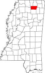
Union County, Mississippi Basics:
Union County Mississippi - Government Site
Population: 27,398
Area: 416 square miles
County seat: New Albany
Area code(s) in use: 662
Time zone: CST
High school graduate or higher: 75.6%
Bachelor's degree or higher: 14.8%
Median household income: $36,582
Persons in poverty: 24.5%
Home ownership rate: 73.0%
Mean travel time to work: 24.0 minutes
Adjacent counties:
Benton Lafayette Lee Marshall Pontotoc Prentiss Tippah
Places in Union County, Mississippi
New Albany-Union County Airport,
Union County Landing Strip Alpine Volunteer Fire Department,
Center Volunteer Fire Department,
East Union Volunteer Fire Department Station 1,
East Union Volunteer Fire Department Station 2,
Ingomar Volunteer Fire Department,
Myrtle Volunteer Fire Department,
New Albany City Hall,
New Albany Fire Department Station 1 Headquarters,
New Albany Fire Department Station 2,
North Haven Volunteer Fire Department,
Northeast Union Rural Fire Department Station 1 Headquarters,
Northeast Union Rural Fire Department Station 2,
Pinedale Volunteer Fire Department,
Southeast Union Volunteer Fire Department Station 1 Headquarters,
Southeast Union Volunteer Fire Department Station 2,
Union County Courthouse,
West Union Volunteer Fire Department Adair Cemetery,
Amaziah Cemetery, Ayers Cemetery,
Baker Cemetery,
Baker Cemetery, Baker Cemetery,
Barnett Cemetery,
Bartlett Cemetery,
Bell Cemetery,
Bethel Cemetery,
Bethlehem Cemetery,
Beulah Cemetery,
Blue Springs Cemetery,
Candy Hill Cemetery,
Carr Cemetery,
Center Cemetery,
Coleman Cemetery,
Concord Cemetery,
Damascus Cemetery, Davis Cemetery, Doxey Cemetery, Duncan Cemetery,
Dunlap Cemetery,
Ebenezer Cemetery,
Ellistown Cemetery,
Fairfield Cemetery, Folsom Cemetery,
Friendship Cemetery, Gerzium Cemetery, Givens Cemetery,
Glenfield Cemetery,
Hall Cemetery, Hall Cemetery,
Henry Cemetery,
Hopewell Cemetery, Hoyle Cemetery,
Ingomar Cemetery,
Jones Memorial Cemetery,
Lebanon Cemetery,
Liberty Cemetery,
Locust Grove Cemetery,
Macedonia Cemetery,
Martin Cemetery,
McAllister Cemetery,
McWhorter Cemetery,
Miears Cemetery, Milsaps Cemetery,
Mount Gilead Cemetery,
Mount Olivet Cemetery,
Mount Zion Cemetery,
Myrtle Cemetery,
New Albany Cemetery,
New Harmony Cemetery,
New Hope Cemetery,
New Oak Grove Cemetery, Oak Plain Cemetery, Old Fredonia Cemetery,
Old Oak Grove Cemetery,
Oliver Cemetery, Pass Cemetery,
Pisgah Cemetery,
Pleasant Grove Cemetery,
Pleasant Hill Cemetery,
Pleasant Ridge Cemetery,
Red Hill Cemetery,
Roach Cemetery,
Salem Cemetery,
Snider Cemetery,
Stack Cemetery,
Stone Cemetery,
Thompson Cemetery,
Union Hill Cemetery,
Vista Memorial Park Cemetery,
Wallersville Cemetery,
Wells Chapel Cemetery,
Wiley Cemetery,
Wilkins Cemetery,
Zion Hill Cemetery,
Zion Hill Cemetery Amaziah Church,
Antioch Church,
Beaver Dam Church,
Beech Springs Church,
Bethel Church,
Bethlehem Church,
Beulah Church,
Blue Springs Baptist Church,
Bois D'Arc Church,
Calvary United Methodist Church,
Center Baptist Church,
Church of Christ,
Cleveland Street Presbyterian Church,
Ebenezer Church,
Enterprise Baptist Church,
Enterprise Church,
Faith Church,
First Baptist Church,
First United Methodist Church,
Fredonia Church,
Glenfield Baptist Church,
Harmony Church,
Hillcrest Baptist Church,
Hopewell Church,
Ingomar Baptist Church,
Jamieson Grove Church,
Jericho Baptist Church,
Jones Chapel,
Keownville Baptist Church,
Liberty Baptist Church,
Liberty Church,
Locust Grove Baptist Church,
Macedonia Church,
Martin Church,
Mount Gillard Church,
Mount Olive Church,
Mount Zion Church,
New Oak Grove Church,
New Prospect Church,
Northside Baptist Church,
Oak Grove Church,
Oak Hill Church,
Oak View Church,
Old Oak Grove Church,
Palestine Church,
Piney Grove Church,
Pleasant Grove Church,
Pleasant Hill Church,
Pleasant Ridge Baptist Church,
Pleasantdale Church,
Poolville Church,
Prospect Church,
Red Hill Church,
Saint Francis of Assisi Catholic Church,
Saint Marys Church,
Salem Church,
Shady Grove Church,
Stewarts Chapel,
Union Grove Church,
Union Hill Church,
Victory Church of the Lord Jesus Christ,
Wallerville Baptist Church,
Wells Chapel,
Wilkins Church,
Zion Chapel,
Zion Hill Church Rocky Ford (historical) Arrowhead Lake Dam,
Ayers Watershed UT-4-1 Dam,
Bagwell Lake Dam,
Baird Lake Dam,
Baker Lake Dam,
Ballard Pond Dam,
Billy Ferrell Pond Dam,
Carnell Lake Dam,
Coker Lake Dam,
Craig Lake,
Crone Lake Dam,
Darden Lake Dam,
Doctor E E Bramlitt Pond Dam,
Ellis Lake Dam,
Hell Creek Structure LT-9b-2 Dam,
Jack Dowdy Pond Dam,
Kitchings Lake Dam,
Lake Lynda Dam,
Locks Watershed LT-9a-1 Dam,
Locks Watershed LT-9a-3 Dam,
Long Lake Dam,
Martintown Recreational Lake Dam,
Mill Watershed LT-14b-1 Dam,
Mill Watershed LT-14b-2 Dam,
Mill Watershed LT-14b-5 Dam,
Mosley Lake Dam,
New Albany Sewage Lagoon Dam,
Newtons Lake Dam,
Okonatie Watershed UT-25-1 Dam,
Okonatie Watershed UT-25-2 Dam,
Pickett Lake Dam,
Ralph Harris Pond Dam,
Robbins Lake Dam,
Roberts Lake Dam,
Roger Elder Pond Dam,
Rowan Lake Dam,
Roy Jordan Lake Dam,
Roy Starnes Pond Dam,
Spencer Lake Dam,
Springdale Lake Dam,
Tate Lake Dam,
Town Creek Structure 19 Dam,
Town Creek Structure 20 Dam,
Town Creek Structure 28 Dam,
Town Creek Structure 29 Dam,
Towncreek Watershed 17 Dam,
Towncreek Watershed 18 Dam,
Union County Lake Dam,
Utley Lake Dam,
Wicker Lake Dam,
Wicker Lake Dam,
Wilkerson Pond Dam King Creek Bottoms Blue Cut Baptist Memorial Hospital, Shands Hospital (historical)
Barnes Lake,
Smith Lake,
Springdale Lakes Alberson (historical),
Beulah (historical),
Bighams Mill (historical),
Buncombe (historical),
Camp Armstrong,
Collins (historical),
Concord (historical),
Gale (historical),
Gibsonville (historical),
Lenox (historical),
New Albany Country Club,
Oaks Country Club,
Oco (historical),
Owen (historical),
Peck (historical),
Plentitude (historical),
Rockwell (historical),
Turkland (historical) Alabama Street Park,
Shady Dell Park Alpine,
Baker,
Bald Hill,
Beacon Hill,
Blue Springs,
Branyan,
Center,
Concord,
Darden,
Ellistown,
Enterprise,
Etta,
Fairfield,
Fairview,
Flatwood,
Gallway,
Glenfield,
Graham,
Halltown,
Ingomar,
Jericho,
Keownville,
Locum,
Locust Grove,
Macedonia,
Martintown,
Mitchell,
Molino,
Mound City,
Myrtle,
New Albany,
New Harmony,
North Haven,
Old Myrtle,
Parks,
Pinedale,
Pleasant Hill,
Pleasant Ridge,
Poolville,
Pumpkin Center,
Reese,
Shari,
Smalco,
Union Hill,
Wallerville Alpine Post Office (historical), Baker Post Office (historical), Darden Post Office (historical), Ellistown Post Office (historical),
Fairview Post Office (historical), Glenfield Post Office (historical), Ingomar Post Office (historical), Keownville Post Office (historical), Molino Post Office (historical),
New Albany Post Office, Rockwall Post Office (historical), Wallerville Post Office (historical)
Ayers Lake,
County Lake,
Darden Lake,
Lake Arrowhead,
Lake Lynda,
Mill Lake Pea Ridge Blue Springs Normal College (historical),
Branyan School,
Central Middle School,
Daniel High School,
East Union School,
Ford Elementary School,
Ingomar School,
Liberty School, Locum School (historical),
Lone Star School,
Mattie Thompson Elementary School,
Mitchell School, Mount Eron School (historical),
Mount Olive School,
Myrtle School,
New Harmony School (historical),
Red Hill School,
Saint Marys School,
Shiloh School,
Tippah-Union School,
Union Grove School,
Union School,
West Union School Ayers Creek,
Beulah Creek,
Big Creek,
Bridge Creek,
Brown Creek,
Bussel Creek,
Byers Creek,
Caldwell Creek,
Camp Branch,
Camp Branch,
Cane Creek,
Cane Creek,
Damnation Creek,
Daniel Creek,
Darling Branch,
East Branch Lockes Creek,
East Branch Okannatie Creek,
Fice Creek,
Floyd Creek,
Franklin Creek,
Frazier Creek,
Hall Creek,
Hatchie Branch,
Hell Creek,
Hickey Branch,
Jasper Creek,
Jenny Branch,
Jones Creek,
King Creek,
Lappatubby Creek,
Little Camp Creek,
Little Creek,
Little Mud Creek,
Lockes Creek,
Martin Branch,
McAllister Creek,
McDaniel Branch,
McWhorter Creek,
Middle Branch Wilhite Creek,
Mill Creek,
Mill Creek,
Mitchell Creek,
Moore Branch,
Mud Creek,
North Branch King Creek,
North Branch Wilhite Creek,
Novell Creek,
Okannatie Creek,
Owens Branch,
Parnell Creek,
Pickens Creek,
Pinhook Creek,
Poplar Springs Creek,
Popular Springs Creek,
Possum Creek,
Rampley Branch,
Rochester Creek,
Ryan Creek,
Sand Creek,
Sawmill Creek,
South Branch King Creek,
South Branch Wilhite Creek,
Spencer Creek,
Spout Spring Branch,
Terry Creek,
Tywhiskey Creek,
West Branch Lockes Creek,
West Branch Okannatie Creek,
Wilhite Creek Bart Hill,
Briar Mountain,
Buncombe Hill,
Darden Hills,
Davis Hill,
Grubb Hill,
Luke Hill,
Rakestraw Mountain,
Rockpile Hill,
Sapling Mountain,
Sweden Hill Center Lookout Tower,
Myrtle Lookout Tower,
WNAU-AM (New Albany),
WOKM-FM (New Albany),
WOKM-FM (New Albany),

