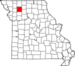
Daviess County, Missouri Basics:
Daviess County Missouri - Government Site
Population: 8,270
Area: 563 square miles
County seat: Gallatin
Area code(s) in use: 660
Time zone: CST
High school graduate or higher: 83.8%
Bachelor's degree or higher: 16.7%
Median household income: $42,617
Persons in poverty: 14.3%
Home ownership rate: 77.2%
Mean travel time to work: 29.6 minutes
Adjacent counties:
Caldwell Clinton DeKalb Gentry Grundy Harrison Livingston
Places in Daviess County, Missouri
Lake Viking Airport,
Longwood Manufacturing Corp Airport,
Spillman Field Airport,
Watson Airport Mooney Bridge Coffey Fire Protection District,
Daviess County Sheriff's Office,
Gallatin Fire Protection District,
Gallatin Police Department,
Jameson Volunteer Fire Protection District,
Jamesport Volunteer Fire Department,
Kidder - Altamont - Winston Fire Protection District Winston,
Kidder - Altamont - Winston Volunteer Fire Protection District Altamont,
Lock Springs Fire Protection District,
Pattonsburg Fire Department,
Viking Valley Fire Department Civil Bend Cemetery,
Civil Bend Christian Cemetery,
Cope Cemetery,
Craborchard Cemetery,
Creekmore Cemetery,
Everly Cemetery,
Frazier Cemetery,
Greenwood Cemetery,
Hill Cemetery,
Hillcrest Cemetery,
Jamesport Memorial Cemetery,
Mount Ayr Cemetery,
Muddy Cemetery,
Old Union Cemetery,
Pilot Grove Number 2 Cemetery,
Reid Cemetery,
Savage Cemetery,
Waters Cemetery,
Winston Cemetery,
Wooderson Cemetery Lake Viking Census Designated Place Alta Vista Church,
Best Church,
Bethel Church (historical),
Centenary Church,
Clear Creek Church,
Craborchard Church (historical),
Fairview Church,
Grand River Church,
Heath Church,
Hickory Creek Church (historical),
Monroe Chapel (historical),
Mount Olive Church,
Mount Zion Church (historical),
New Hope Church,
New Salem Church (historical),
Pilot Grove Number 1 Church,
Pilot Grove Number Two Church,
Prairie City Church,
Prairie Valley Church (historical),
Union Church (historical),
Wesley Chapel East Dam,
Froman Lake Dam,
Gates Lake Dam,
Grindstone-Lost Muddy Creek Watershed Dam F-30,
Grindstone-Lost-Muddy Creek Watershed Dam F-20,
Grindstone-Lost-Muddy Creek Watershed Dam F-32,
Hallman Lake Dam,
Jamesport City Dam,
Jamesport Lake Dam,
Johnson Land Development Lake Dam,
Lake Viking Dam,
Woodward Lake Dam,
Woodworth Lake Dam,
Youtsey Lake Dam Osborn Lake,
Packwood Lake,
South Lake Brownsdale (historical), Bucklin, Coon Grove, DeHarte Siding, Dice, Eclipse, Edray,
Highland Switch, Hobsons Choice,
Holmes Bend Public Access, Hopewell,
Wabash Crossing Public Access, Wood Creek
Adam-Ondi-Ahman,
Alta Vista,
Altamont, Auberry Grove,
Bancroft,
Blake,
Carlow,
Civil Bend,
Coffey, Crittenden,
Cypress, Dayton City, Doodleville,
Gallatin,
Jameson,
Jamesport,
Lock Springs,
Mabel,
Madelaine (historical),
Magill, Millport,
Old Pattonsburg,
Pattonsburg, Pilot Grove, Prairie City,
Salem Coffey P O and Station, Victoria,
Wabash Crossing,
Winston Africa Post Office, Boxford Post Office,
Brownsdale Post Office, Madeline Post Office, Mark Post Office, New Famington Post Office, Pin Oak Grove Post Office
Billy Herrin Lake,
City Lake,
Cook Lake,
Jamesport Community Lake,
Jamesport Lake,
Jamesport Municipal Lake,
Johnson Lake,
Lake Viking,
Pattonsburg Lake,
Walton Lake Allen School,
Allen School (historical),
Alta Vista School (historical),
Arnold School (historical), Bancroft School, Bardrick School,
Barnett School,
Bear Branch School,
Bell Tower School (historical),
Blake School (historical), Blakley School,
Blue School,
Boyd School (historical),
Broderick School,
Brown School (historical),
Calfpen School,
Castor School (historical),
Center Point School (historical),
Charity School (historical),
Civil Bend Center School (historical),
Clear Creek School, Cold Spring School,
Conestoga School,
Cope School,
Cottonwood School (historical),
Covel D Searcy Elementary School, Crab Orchard School, Cross Roads School,
Dilly School (historical),
Eureka School (historical),
Everly School (historical),
Excelsior School (historical),
Fairview School,
Fairview School (historical),
Feurt School,
Foley School (historical), Fountian Blue School,
Freeport School (historical),
Frogneck School (historical),
Gallatin High School,
Goodbar School,
Griffin School (historical), Hale School,
Hale School (historical),
Haw Branch School,
Heath School (historical),
Hickory Grove School, Highland School,
Hopkins School (historical),
Island Number 10 School (historical),
Johnson School (historical),
Koger School,
Land School, Lee School,
Liberty School (historical),
Lone Cottage School (historical), Lone Cottonwood School, Lone Hickory School,
Lone Star School (historical), Lost School,
Madison School,
Mann School,
Mc Culley School (historical),
McCleary School,
McClung School, Miller School,
Miller School (historical),
Mount Pleasant School,
Netherton School (historical),
North Daviess Elementary School,
North Daviess High School,
Oak Grove School (historical),
Oak Ridge School (historical),
Pattonsburg Elementary School,
Pattonsburg High School,
Pilot Grove School (historical),
Pleasant Grove School (historical),
Pleasant Grove School (historical),
Powell School (historical),
Prairie Center School,
Prairie Hall School (historical),
Prairie Hill School (historical),
Prairie View School (historical),
Ray School,
Red School (historical),
Reed School (historical),
Roasting Ear School (historical), Rosedale School,
Round Tower School,
Scotland School (historical),
Selle School,
Shady Grove School,
Shinar School, Shriver School,
Smith School (historical),
Splawn Ridge School,
Spring Hill School (historical), Stitt School,
Stony Point School (historical),
Swisher School, Tolen School,
Tri - County Elementary School,
Tri - County High School,
Trotter School, Union School,
Victoria School (historical),
Virginia Ridge School, Walnut Grove School,
Walnut Grove School (historical),
Whitt School,
Winston Elementary School,
Winston High School,
Wood School (historical),
Wooderson School (historical) Bear Branch,
Big Creek,
Big Muddy Creek, Big Run, Big Slough,
Brushy Creek,
Brushy Creek, Bullards Branch,
Clear Creek,
Cottonwood Creek,
Cottonwood Creek, Crystal Springs Branch,
Cypress Creek, Cypress Creek,
Dog Creek,
East Brushy Creek,
East Creek,
Goose Creek,
Grindstone Creek,
Haw Branch,
Henderson Creek,
Herald Branch,
Hickory Creek,
Hog Creek,
Honey Creek,
Hurricane Branch,
Kettle Creek,
Koger Branch,
Larry Creek,
Lick Fork,
Little Creek,
Little Creek,
Little Cypress Creek,
Little Muddy Creek,
Little Sampson Creek,
Long Branch,
Lost Creek,
Marrowbone Creek,
Mason Creek,
Muddy Creek,
Muddy Creek,
Nobel Branch,
Noll Branch,
Owl Creek,
Pilot Grove Creek,
Sampson Creek,
South Big Creek,
Thompson Creek,
Van Over Branch,
West Brushy Creek,

