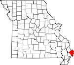
Mississippi County, Missouri Basics:
Mississippi County Missouri - Government Site
Population: 14,330
Area: 412 square miles
County seat: Charleston
Area code(s) in use: 573
Time zone: CST
High school graduate or higher: 69.5%
Bachelor's degree or higher: 10.5%
Median household income: $29,606
Persons in poverty: 22.9%
Home ownership rate: 65.4%
Mean travel time to work: 19.8 minutes
Adjacent counties:
Alexander (IL) Ballard (KY) Carlisle (KY) Fulton (KY) Hickman (KY) New Madrid Pulaski (IL) Scott
Places in Mississippi County, Missouri
McDowell-Schmid Airport,
Mississippi County Airport Island Number 7, Long Prairie, Mathews Prairie,
New Madrid Floodway,
Three States Towhead Dorena Towhead,
Medley Bar Beckwith Bend,
Bend of Island Number 8,
Dog Tooth Bend Anniston Fire Department,
Anniston Police Department,
Bertrand Fire Department,
Charleston Police Department,
East Prairie Fire Department,
East Prairie Police Department,
Mississippi County Sheriff's Office,
Southeast Correctional Center,
Wyatt Volunteer Fire Department Bayou Ditch,
Big Lake Ditch,
Brewer Lake Ditch,
Fish Lake Ditch,
Glory Bayou,
Lateral Number 1,
Lateral Number 1 (historical),
Lateral Number 3,
Lateral Number 7,
Lee Rowe Ditch,
Maple Slough Ditch,
Saint James Ditch,
Saint Johns Diversion Ditch,
Spillway Ditch,
Wilkerson Ditch,
Wolf Hole,
Wolf Hole Lateral,
Wolf Hole Lateral Birds Point Allen Cemetery,
Armour Cemetery,
Barker Cemetery,
Barnes Cemetery,
Bird Cemetery,
Boston Cemetery (historical),
Calhoun Cemetery (historical),
Cooley Cemetery (historical),
Dogwood Cemetery,
Griggs Cemetery,
Independent Order of Odd Fellows Cemetery,
Ivie Cemetery,
Lee Cemetery,
Lee Cemetery,
O'Bryan Cemetery,
Oak Grove Cemetery,
Texas Bend Cemetery,
Thompson Cemetery,
Travis Cemetery,
Wolf Island Cemetery Bement Church, Bethany Church,
Bethlehem Church,
Bridges Church,
Church of God,
Concord Church (historical), Cypress Church,
Deventer Church (historical),
Deventer Church (historical),
Dogwood Church,
Dorena Church,
Dorena Church (historical),
Dorena Church (historical),
Gravel Ridge Church,
Halloway Church (historical), Harmony Baptist Church, Haws Chapel, Kays Chapel, Ketrons Chapel,
Lower Crosno Church (historical),
Macedonia Church,
Miller Church (historical),
Mounds Church,
Mount Eria Church,
Mount Hope Church, Mount Moriah Baptist Church,
Mount Zion Church,
New Bethel Church,
New Hope Church,
Pinhook Church (historical),
Pulltight Church,
Rush Ridge Church,
Saint Francis de Dales Church,
Saint Mattews Church,
Saint Pauls Church,
Sassafras Ridge Church (historical),
Sweet Home Church (historical),
Wolf Island Church (historical),
Wolf Island Church (historical) Big Oak Lake Dam,
Ricefield Pond Dam,
Upper Big Lake Dam Black Bayou,
Fourmile Pond,
Newcums Chute Dixon Island,
Moore Island,
O'Bryan Towhead,
Sliding Towhead,
Thompson Towhead Barnell Lake (historical), Bear Lake,
Big Lake,
Big Muskrat Pond (historical),
Big Oak Lake,
Black Bayou, Bonnet Lake,
Bratcher Lake,
Brewer Lake,
Chute of Island Number 7, Cypress Lake, Dead Cypress Lake,
Deans Blue Hole,
Dorena Crevasse,
Eagle Lake (historical),
Fish Lake,
Grassy Pond (historical),
Henson Lake,
Little Eagle Pond (historical), Muskrat Lake,
Nolen Blue Hole,
O'Rourkes Blue Hole,
Otter Pond,
Sixmile Ponds, Teapot Lake,
Tenmile Pond,
Thirtyfour Corner Blue Hole,
Tom Bird Blue Hole Belmont Revetment (historical),
Bend of Island Number Eight Revetment (historical),
Birds Point New Madrid Levee,
Greenfield Bend Revetment (historical),
Pritchard Revetment, Set Back Levee
Beckwith,
Belmont,
Charleston Plaza,
Crenshaw, Dead Cottonwood Tree,
Defield, Harrison,
Howletts (historical), Hunters Oak, Langhans Mill, Luby,
Lucas Landing (historical),
McFadden Landing,
Medley Landing,
Miller Landing (historical),
Norfolk Landing,
O'Bryan Landing,
Parker Landing,
Pritchard Landing,
Rodney,
Thompson Landing,
Three States Landing,
Vater (historical), Woodsdale
Iron Banks
Big Oak Tree State Park,
Towosahgy State Park Airline Acres,
Alfalfa Center,
Anniston, Baldwinsville,
Belmont Landing,
Bertrand,
Birds Point,
Buckeye,
Catalpa,
Charleston,
Coulter,
Crosno,
Deventer,
Dogwood,
Dorena,
Dorena Landing,
East Prairie,
Fuget,
Greenfield,
Hallett (historical),
Henson, Hopewell,
Hough,
Never Spur (historical),
Norfolk (historical), Oak Grove, Ohio City,
Pinhook,
Pulltight,
Rumsey Spur (historical),
Rushs Ridge,
Samos,
Texas Bend,
Thirtyfour Corner,
Three States,
Whiting,
Wilson City,
Wolf Island,
Wyatt Ayers Pond (historical),
Rice Pond,
Ricefield Pond Eagle Knoll Cypress Ridge,
O'Bryan Ridge, Pinhook Ridge, Woolridge
Armour School,
Bement School,
Big Lake School (historical),
Big Lake School (historical),
Bird Mill School (historical),
Birds Point School (historical),
Bridges School,
Concord School,
Concord School (historical),
Crosno School (historical),
Deventer School (historical),
Dirk Goodin School (historical),
Dirk School (historical),
Dogwood School (historical),
Dorena School,
Dorena School,
Doyle School,
Eugene Field School,
Fish Lake School (historical),
Fox School (historical),
Grey School,
Grigsby School,
Grigsby School (historical),
Halloway School (historical),
Harriman School,
Henson School (historical), Holloway School, Hurricane School, Indian Grove School, James Bayou School,
Lincoln School,
Little Rush Wood School (historical),
Locust Grove School,
Lower Crosno School (historical),
Lower Dogwood School,
Mark Twan School,
Martin School,
Medley School (historical),
Miller School (historical),
Mound School (historical),
Norfolk School District Number 6,
Pinhook School,
Pinhook School (historical),
Pinhook School (historical),
Rush Ridge School,
Russell School (historical),
Saint Henrys School,
Sassafras Ridge School,
Sassafras Ridge School,
Texas Bend School,
Texas Bend School (historical),
Thirty Four Corner School (historical),
Thompson Bend School (historical),
Three States School (historical),
Travel Rest School (historical), Upper Crosno School, Walnut Grove School,
Warren E Hearnes School,
Washington School,
Webb School,
Windyville School (historical),
Wolf Island School (historical),
Wolf Island School (historical),
Woolridge School Big Lake Bayou,
Dry Bayou, East Bayou,
James Bayou,
James Bayou,
James Bayou (historical),
Number 3 Chute,
Stevenson Bayou Hoen Slough (historical), Wilsons Bayou
KCHR-AM (Charleston),
KYMO-AM (East Prairie) Roark Hole,

