Mineral County, Nevada Basics:


Mineral County Nevada - Government Site

Population: 4,694
Area: 3753 square miles
County seat: Hawthorne
Area code(s) in use: 775
Time zone: PST
High school graduate or higher: 86.8%
Bachelor's degree or higher: 7.0%
Median household income: $33,547
Persons in poverty: 23.0%
Home ownership rate: 70.9%
Mean travel time to work: 12.3 minutes

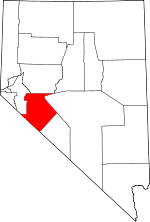
Adjacent counties:
Churchill  Esmeralda  Lyon  Mono (CA)  Nye  

Find in Nevada

Map of the Mineral County area


Our detail map of Mineral County shows the Mineral County, Nevada boundary lines and other interesting items.

Places in Mineral County, Nevada

  Airports     show all on map

Hawthorne Industrial Airport, Mina Airport, Rawhide Landing Strip, Schurz Airport

  Basins     show all on map

Gabbs Valley, Huntoon Valley, Little Huntoon Valley, Soda Spring Valley, Walker River Valley

  Beaches     show all on map

Navy Beach, Sportsmans Beach

  Buildings     show all on map

Day and Zimmerman Hawthorne Corporation Fire and Emergency Services, Hawthorne Volunteer Fire Department, Luning Volunteer Fire Department, Mina Volunteer Fire Department, Mineral County Sheriff's Office, Nevada Highway Patrol Northern Command West Hawthorne, Walker Lake Volunteer Fire Department, Walker River - Schurz Fire Department

  Canals     show all on map

Canal Number One, Canal Number Two, Drain Number One, Lateral One-A, Lateral Two-A, Lateral Two-B, Lateral Two-D, Lateral Two-E, Stucky Ditch (historical)

  Capes     show all on map

Pelican Point, Tamarack Point

  Cemeteries     show all on map

Candelaria Cemetery, Mina Cemetery, Rawhide Cemetery

  Census     show all on map

Hawthorne Census Designated Place, Mina Census Designated Place, Schurz Census Designated Place, Walker Lake Census Designated Place

  Craters     show all on map

Aurora Crater

  Dams     show all on map

Black Beauty Dam, Cat Creek Dam, Rose Creek Dam, Weber Dam

  Flats     show all on map

Buckley Flat, Calavada Flat, Garfield Flat, Gregory Flats, Lapon Meadows, Little Whisky Flat, McBride Flat, Rattlesnake Flat, Rhodes Salt Marsh, Sunrise Flat, Truman Meadows, Whisky Flat, Win Wan Flat

  Forests     show all on map

Bridgeport Ranger District

  Gaps     show all on map

Anchorite Pass, Calavada Summit, Cedar Summit, Dicalite Summit, Little Summit, Lucky Boy Pass, Montgomery Pass, Petrified Summit, Rattlesnake Summit, Rhyolite Pass, Ryan Pass, The Narrows, Tim Holt Summit, Wheeler Pass

  Harbors     show all on map

Walker Lake Boat Harbor

  Hospitals     show all on map

Lefa Seran Skilled Nursing Facility, Mount Grant General Hospital, Walker River Hospital

  Lakes     show all on map

Alkali Lake, McNamara Lake, Murphy Pond, Walker Lake

  Locales     show all on map

Aldrich Station, Antelope Mill (historical), Antone Station (historical), Aurora Mill (historical), Belleville Tailings Plant, Birch (historical), Black Mountain Dead Man Drift Fence, Borus (historical), Candelaria Mines Company Mill (historical), Candelaria Water Works and Milling Company Mill, Car Frame Windmill, China Camp, Chinese Camp, Claytons Ranch (historical), Cottonwood (historical), Cow Camp, Deadhorse Wells, Deep Hollow (historical), Dover Siding (historical), Dunham Mill Site, Eddyville, Endowment Mill (historical), Esmeralda Mill (historical), Evergreen Ranch (historical), Federal Mining and Engineering Company Mill, Finger Rock Station (historical), Five Mile House (historical), Five Mile Station (historical), Fletcher Camp (historical), Foreys Toll House (historical), Four Mile Fence, Gabbs Valley Ranch, Garfield Mill, Gates Mill, Gibbons Mill, Gillis (historical), Gillis Camp, Gillis Station (historical), H Harris Mill (historical), Hawthorne Speedway, Hereford Valley Ranch, Hereford Valley Ranch, Hulches Canyon (historical), Indian Queen Quartz Mill (historical), Junction House (historical), Kaiser Mine Camp (historical), Kinkead Mill, Klinker Mill (historical), Klondike (historical), La Panta, Lake Peak, London Silver Lead Mines Company Mill (historical), Lone Star Ranch (historical), Lookout Mountain (historical), Lorena, Lucky Boy Holding Corral (historical), Lucky Boy Ranch, Luning Station, Magnus (historical), Mangum (historical), Mark Twain Camp, McKay City (historical), Modoc Siding (historical), Moho (historical), Monte Cristo (historical), Moses Mill (historical), Mount Diablo Reduction Works (historical), Mount Grant Lodge, Mud Windmill, Napa Mill (historical), National Mill, Nevada Scheelite Camp, Nevada Scheelite Mill, New Boston Mill, New York Station (historical), Nichols (historical), Ninemile Ranch, Nolan (historical), Northern Belle Companys Lower Mill, Northern Belle Companys Upper Mill, Oro City (historical), Pamlico, Pine Creek Mill (historical), Pioneer Mill (historical), Queen (historical), Queen Mill (historical), Rattlesnake Garfield Drift Fence, Rawhide Ranch, Raydel (historical), Redlich, Reese River Fence, Regent (historical), Rhodes Marsh Station (historical), Rutty Mill (historical), Sand Spring (historical), Sargent Well Spring Holding Corral, Silex (historical), Smith Borax Reduction Works (historical), Spring House (historical), Spring Ranch (historical), Stansfield (historical), Sullivans Camp (historical), Summit (historical), Summit Spring Drift Fence, Summit Station Holding Corral, Sunny Side Ranch (historical), Sweetwater Ranch Company Whisky Flat Unit, Teals (historical), Teese and Company Mill (historical), Temple Chace Ranch (historical), Union Mill (historical), Verdi Vista Ranch (historical), Virginia, Walker (historical), Wassons Camp (historical), West Rattlesnake Drift Fence, Whiskey Flat Holding Corral, Williams House (historical), Zais (historical)

  Military     show all on map

Hawthorne Army Depot

  Mines     show all on map

Ackerman Mine, Acme Copper Mine, Allen Mine, American Flag Mine, American Mining Corporation, Argentum Mine, Arthur Salt and Borax Placer Mine, Ashby Gold Mines Incorporated, Atom Lorna Mine, Aurora Consolidated Mine, Aurora Tunnel, Badger Mine, Bataan Mine, Belleville Mine, Bellmarte Mine, Bethania Mine, Bettles Mine, Betty Mine, Big Deal Mine, Big Indian Mine, Birdsong Mine, Bismark Mine, Black Butte Mine, Black Eagle Mine, Black Hawk Mine, Black Jack Mine, Black Metallic Mine, Blanch Mine, Blue Dump Mine, Blue Ribbon Mine, Blue Ridge Tungsten Mine, Blue Sphinx, Bluelight Mine, Borealis Mine, Bounce Mine, Broken Hills Mine, Brown Mine, Buckley Mine, Bullskin Mountain Mine, Cardinal Mine, Centipede Mine, Central Mine, Champion Anderson Mine, Chesco Mine, Chiatovich Mine, Chief Mine, Clay Peters Mine, Columbus Consolidated Mine, Columbus Mine, Combination Mining Company Mine, Copper Chief Mine, Copper Head Mine, Copper Mountain Mine, Copper Queen Mine, Cory Mine, Coveney Mine, Cute Maid Mine, Deep Mines, Defender Mine, Desert Scheelite Mine, Dispozitch Mine, Douglas Mine (historical), Dover Mine, Drew Mine, Dunlap Mine, Eagle Mine, Eagle Mine, Eagleville Mine, Eastside Mine, Emma Mine, Endowment Mine, Equator Mine, Esmeralda Tunnel, Evening Star Mine, Figge Hoblyn Mine, Flynn Mine, Fortuna Mine, Fottler Mine, Garfield Mine, Garfield Salt and Borax Placer Mine, Garnet Mine, Gem Mine, Gentry Mine, Georgine Mine, Giroux Mine, Giroux Mine, Gold Bar Mine, Gold Bug Mine, Gold Fund Mine, Gold Pen Mine, Gold Reef Mine, Golden Bomber Mine, Golden Eagle Mine, Golden Mile Mine, Golden Pen Mine, Goldrange Copper Mine, Good Hope Mine, Good Hope Mine, Good Hope Number 2 Mine, Granite Mine, Grant Mountain Gold Mine, Grassi Mine, Green Talc Mine, Greentale Mine, Grutt Mines, Gunmetal Mine, Hardluck Mine, Harvey Taylor Mine, Hasbrouck Mine, Hecla Mine, Hefler Tungsten Mine, Hitt Mine, Holiday Uranium Mine, Homestead Mine, Hontone Mine (historical), Hooper Mine, Horatio Tunnel, Houghton O'Boyle Mine, Ideal Mine, Illinois Tunnel, Inman Mine, Iron Butte Mine, Iron Gate Mine, Jasper Mine, Jeep Mine, Juanita Tunnel, Juniper Mine, Kaiser Mine, Kay Mine, Keg Mine, Kelly and Clark Mine, Kernick Mine, King Mine, Kope Scheelite Mine, La Panta Mine, Lakeview Mine, Last Chance Mine, Lazy Man Mine, Lemr Mine, Lindsey Mine, Lithia Mine, Little Chief Mine, Loman Mine, Lone Star Mine, Lost Steers Mine, Lou Mine, Lucky Boy Mine, Lucky Four Mine, Lucky Hill Mine, Mable Mine, Mammoth Mine, Marietta Mines, Marlview Mine, Martinez Tunnel, Mary Mine, Maryann Mine, Mascot Mine, Mayflower Mine, Metallic Mine, Metallic-Equator Joint Shaft, Mina Gold Mines Companys Mine, Mina Mine, Moho Mine, Monarch Mining Company, Montezuma Mine, Montezuma Tunnel, Montgomery Summit Mine, Montreal Mine, Montreal Tunnel, Morning Star Mine, Mosier Mine, Mount Diablo Mine, Mountain View Mine, National Tunnel, Nevada New Mines, Nevada Rand Mine, Nevada Scheelite Mine, New Party Mine, New Potosi Mine, Newmont Mine, Noquez Mine, Northern Belle Mine, Northern Lights Mine, Nun Mine, October Mine, OMCO Mine, One Thousand Nine Hundred Five Mine, Oriole Mine, Orphan Boy Mine, Pamlico Mines, Pappinaux Mine, Penrod Mine, Pepper Mine, Peru Mine, Petrol Mine, Pine Crow Mine, Pine Tree Mine, Poinsettia Mine, Poor Boy Mine, Popper Mine, Potosi Mine, Princess Mine, Quailey Mine, Rawhide Mine, Rawhide Tungsten Mine, Rawhide Victor Mine, Red Granite Mine, Redwing Mine, Regan Mine, Reward Mine, Rip Van Winkle Mine, Rising Sun Mine, Rita Mine, Rock Cabin Mine, Roosevelt Mine, Rovada Mining Company Mine, Royal Mine, Rutty Mine, San Felipe Mine, San Francisco Bell Mine, Santa Fe Mine, Scheeline Mines, Scheelite Extension Mine, Seminole Regent Mine, Silver Chief Mine, Silver Dyke Mine, Silver Gulch Mine, Silver King Mine, Silver Moon Mine, Silver Zone Mine, Simon Mine, Snowball Mine, Sullivan Mine, Sunny Slope Mine, Sunnyside Mine, Sunset Mine, Sunset Mine, Sunshine Mine, Swastika Mine, The Victor Mine, Tiffany Mine, Todd Mine, Triumph Mine, Union Tunnel, Vulture Mine, Wallstreet and Turk Mines, Wamsley Mine, Warlock Mine, Wash Vein Mine, Wedge Copper Mine, Western Metals Mine, Wild Rose Mine, Windup Mine, Yankee Girl Mine, Yerington Mountain Copper Company Mine, York Mine

  Parks     show all on map

Lady Bird Park, Walker Lake Recreation Area, Walker Lake State Park

  Pillars     show all on map

Finger Rock

  Populated Places     show all on map

Acme (historical), Aurora (historical), Avalon, Babbitt, Basalt, Belleville (historical), Bley (historical), Bovard (historical), Broken Hills (historical), Buckley Camp (historical), Camp Douglas, Candelaria (historical), Candelaria Junction, Copper City (historical), Copper Hill (historical), Copper Run, Copperfield (historical), Coryville (historical), Cottonwood Well, Del Monte, Dutch Creek (historical), Eagleville (historical), Esmeralda (historical), Fletcher, Garfield (historical), Granite (historical), Hawthorne, Jaggersville, Kinkaid, Loma (historical), Lucky Boy (historical), Luning, Marietta, Metallic City (historical), Midway, Mina, Montelle (historical), Mount Montgomery, Mountain View (historical), New Boston (historical), Omco, Qualeys Camp, Rand (historical), Rawhide, Reservation (historical), Rhodes (historical), Schurz, Schweer Housing Area, Simon (historical), Sodaville, Thorne, Tonopah Junction, Walker Lake, Whiskey Spring (historical), Woodruffs (historical)

  Post Offices     show all on map

Aurora Post Office (historical), Babbitt Branch Post Office, Basalt Post Office (historical), Belleville Post Office (historical), Bley Post Office (historical), Broken Hills Post Office (historical), Buckley Post Office (historical), Candelaria Post Office (historical), Copperfield Post Office (historical), Copperhill Post Office (historical), Coryville Post Office (historical), Dea Post Office (historical), Douglass Post Office (historical), Dutch Creek Post Office (historical), Eagleville Post Office (historical), Esmeralda Post Office (historical), Fletcher Post Office (historical), Garfield Post Office (historical), Granite Post Office (historical), Hawthorne Post Office, Loma Post Office (historical), Luckyboy Post Office (historical), Luning Post Office, Marietta Post Office (historical), Metallic Post Office (historical), Mina Post Office, Montelle Post Office (historical), Mount Montgomery Post Office (historical), Mountain View Post Office (historical), Naval Ammunition Depot Branch Post Office (historical), New Boston Post Office (historical), Omco Post Office (historical), Oro Post Office (historical), Queen Post Office (historical), Rand Post Office (historical), Rawhide Post Office (historical), Redlich Post Office (historical), Reservation Post Office (historical), Schurz Post Office, Simon Post Office (historical), Sodaville Post Office (historical), Thorne Post Office (historical), Woodruff Post Office (historical)

  Ranges     show all on map

Agai Pah Hills, Anchorite Hills, Bodie Mountains, Calico Hills, Candelaria Hills, Cedar Mountains, Excelsior Mountains, Gabbs Valley Range, Garfield Hills, Gillis Range, Gumdrop Hills, Huntoon Mountains, Koegel Hills, Pilot Mountains, Rawhide Hills, Sinkavata Hills, Wassuk Range

  Reservoirs     show all on map

Acme Tank, Acme Tank (historical), Black Beauty Reservoir, Burkham Tank, Cat Creek Reservoir, Garfield Reservoir Number One, Garfield Reservoir Number Three, Garfield Reservoir Number Two, Gundaker Reservoir (historical), Kincaid Reservoir (historical), National Mill Reservoir (historical), Rose Creek Reservoir, Weber Reservoir, Whiskey Flat Reservoir

  Ridges     show all on map

Chukar Ridge, Fissure Ridge, Ghost Dance Ridge, Mystery Ridge, Rand Ridge, Red Ridge

  Schools     show all on map

Hawthorne Elementary School, Hawthorne Primary School, Mina Elementary School, Mineral County High School, Schurz Elementary School, Sky View Academy

  Springs     show all on map

Abraham Spring, Alder Spring, Aspen Spring, Bank Spring, Barrel Spring, Bell Spring, Belleville Spring, Belleville Springs, Benton Spring, Bettles Ranch Spring, Betty Spring, Big Spring, Black Jack Spring, Blue Link Spring, Box Spring, Box Spring, Buck Brush Spring, Buckbrush Spring, Buffington Spring, Buller Spring, Canyon Spring, Cedar Spring, Chipmunk Spring, Cinnabar Spring, Cliff Spring, Company Spring, Cornelius Spring, Corner Spring, Corral Spring, Cottonwood Spring, Cottonwood Spring (historical), Davis Spring, Double Spring, Douglas Spring, Dripping Vat Spring, Dunbarton Spring, Dunlap Tunnel Spring, Fagans Spring, Farrington Spring, Five Mile Spring, Fletcher Spring, Garfield Spring, German Spring, Gillis Spring, Graham Spring, Graham Spring, Granite Spring, Greasewood Spring, Hay Spring, Humdinger Spring, Huntoon Spring, Hussman Spring, Indian Spring, Jacks Spring, Large Williams Spring, Log Cabin Spring, Lost Spring, Lou Spring, Martin Spring, Martinez Spring, McBride Springs, McGregor Spring, Middle Spring, Millsite Spring, Mitchell Spring, Mitchell Spring, Moho Spring, Mud Spring, Mud Spring, Mustang Spring, Omco Spring, Orchard Spring, Paint Rock Spring, Paiute Spring, Pepper Spring, Perry Springs, Petrified Spring, Poinsettia Spring, Point of Hill Spring, Poleline Spring, Pool Spring, Powell Canyon Spring, Powell Flat Spring, Powell Spring, Rabbit Spring, Ramsey Spring, Rawhide Hot Springs, Redrock Spring, Reservation Spring, Roadside Spring, Rock Cabin Spring, Rock Cabin Spring, Rock Canyon Spring, Rock House Spring, Sagehen Spring, Sagundai Spring, Sargent Well Spring, Silver Dyke Spring, Simon Spring, Soda Springs, Sorhouet Springs, South Mitchell Spring, Southern Pacific Spring, Stageroad Spring, Stewart Spring, Stone Cabin Spring, Storey Spring, Sulphur Spring, Sulphur Spring, Summit Spring, Summit Spring, Summit Spring, Tamarack Spring, Taylor Spring, Tom Spring, Tree Spring, Troy Spring, Truman Spring, Tule Spring, Twilight Spring, Upper Benton Spring, Upper Petrified Spring, Upper Powell Canyon Spring, Upper Summit Spring, Warlock Spring, Warner Corral Spring, Wedell Springs, Whiskey Spring, Whisky Spring, White Rock Spring, Wild Cat Spring, Wild Horse Spring, Wild Rose Spring, Wildhorse Spring, Wildrose Spring, Willow Spring, Wilson Spring, Yellow Spring, York Spring

  Streams     show all on map

Alum Creek, Antone Wash, Aurora Creek, Bodie Creek, Brownie Creek, Cat Creek, Corey Creek, Cottonwood Creek, Cottonwood Creek, Dry Creek, Dutch Creek, Eagle Wash, Finger Rock Wash, Garfield Creek, Hidden Wash, House Creek, Hu-Pwi Wash, Huntoon Creek, Jacks Creek, Little Squaw Creek, Middle Fork Cat Creek, North Canyon Creek, North Fork Cat Creek, North Fork Hu-Pwi Wash, Nugent Wash, Omco Wash, Petrified Wash, Phillips Wash, Pizona Creek, Powell Creek, Red Wash Creek, Rose Creek, South Fork Cat Creek, South Fork Hu-Pwi Wash, Squaw Creek, Squaw Creek, Walker River, Willow Creek, Wovoka Wash

  Summits     show all on map

Aurora Hill, Aurora Peak, Bald Mountain, Bald Peak, Balloon Hill, Basalt Peak, Beauty Peak, Big Indian Mountain, Big Kasock Mountain, Black Dyke Mountain, Black Eagle Hill, Black Hills, Black Mountain, Brawley Peaks, Brown Knob, Buckskin Mountain, Buller Mountain, Butler Mountain, Candelaria Mountain, Chicago Mountain, Copper Mountain, Corey Peak, Crazy Hill, Dome Hill, Excelsior Mountain, Gabbs Mountain, Grutt Hill, Gundaker Hill, Hooligan Hill, Humboldt Hill, Indian Head Peak, Last Chance Hill, Little Pilot Peak, Llama Mountain, Mable Mountain, Malapie Hill, Martinez Hill, Martinez Hill, Middle Hill, Miller Mountain, Moho Mountain, Mount Ferguson, Mount Grant, Mount Hicks, Muller Mountain, Murray Hill, Pike Peak, Pilot Cone, Pilot Peak, Powell Mountain, Reservation Hill, Saint Marys Hill, Silver Hill, Simon Mountain, Spring Peak, Squaw Peak, Sugarloaf, Sugarloaf Mountain, Table Mountain, Table Mountain, Thunder Mountain, Volcano Peak, White Mountain

  Swamps     show all on map

Teels Marsh

  Towers     show all on map

Kinkaid Microwave Station, Rabbit Spring Microwave Station

  Valleys     show all on map

Alkali Valley, Baldwin Canyon, Blackrock Gulch, Boundary Canyon, Box Canyon, Bromide Canyon, Buffalo Canyon, Buller Canyon, Chaney Gulch, Cinnabar Canyon, Copper Canyon, Cottonwood Ca�on, Cottonwood Canyon, Cottonwood Canyon, Cottonwood Creek Canyon, Deadman Canyon, Del Monte Canyon, Douglas Canyon, Dunlap Canyon, East Canyon, Esmeralda Ravine, Gillis Ca�on, Gillis Canyon, House Creek Canyon, Jacks Spring Canyon, Jim Canyon, Johnston Canyon, Long Canyon, Long Valley, Mac Canyon, McGill Canyon, Montreal Canyon, Mud Spring Canyon, Never Sweat Canyon, New York Canyon, North Canyon, Paint Rock Canyon, Pamlico Canyon, Paymaster Canyon, Penrod Canyon, Pickhandle Gulch, Powell Canyon, Queen Canyon, Queen Valley, Rattlesnake Canyon, Rebel Canyon, Red Fox Gulch, Redrock Canyon, Reese River Canyon, Rhodes Ca�on, Ryan Canyon, Sheeps Head Canyon, Silver Dyke Canyon, Sonoma Canyon, Stewart Valley, Stingaree Gulch, Stone Cabin Canyon, Superstition Canyon, Telephone Canyon, Truman Canyon, Volcano Canyon, Walker Lake Valley, Water Canyon, West Queen Canyon, Wide Canyon, Wildhorse Canyon, Wildhorse Canyon, Willow Canyon, Willow Ravine, Win Wan Valley

  Wells     show all on map

Antonio Well, Baker Well, Bettles Well, Black Cabin Well, Black Mountain Well, Cedar Mountain Well, Deadhorse Well, Finger Rock Well Number 1, Finger Rock Well Number 2, Finger Rock Well Number Three, Government Well, Granny Goose Well, Huntoon Valley Well Number One, Kaiser Well, Kaiser Well Number Two, Little Bell Flat Well, Luning Well, Murphys Well, Pilot Cone Well, Rattlesnake Well, Sargent Well (historical), Simon Well, Stinson Well, Warrens Well (historical), Water Company Well, Whiskey Flat Well,

Mineral County, Nevada Population By Race (2012 estimate)

RacePopulation
WhiteMineral County White population 3,4413,440  
American IndianMineral County American Indian population 770769
BlackMineral County Black population 211211
MixedMineral County Mixed population 188187
AsianMineral County Asian population 8484
Hawaiian & Pacific IslanderMineral County Hawaiian & Pacific Islander population 54

Additional population tables :
State population table
Nevada population by county