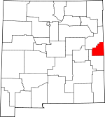
Curry County, New Mexico Basics:
Curry County New Mexico - Government Site
Population: 50,696
Area: 1405 square miles
County seat: Clovis
Area code(s) in use: 505
Time zone: MST
High school graduate or higher: 80.9%
Bachelor's degree or higher: 19.7%
Median household income: $41,250
Persons in poverty: 18.0%
Home ownership rate: 60.8%
Mean travel time to work: 15.5 minutes
Adjacent counties:
Bailey (TX) Deaf Smith (TX) Parmer (TX) Quay Roosevelt
Places in Curry County, New Mexico
Aero Tech Inc Airport,
Cannon Air Force Base,
Clovis Municipal Airport,
Hoffmann Helicopters Heliport,
Lockmiller & Sons Airport,
Mitchell Farms Airport Broadview Fire Department,
Cannon Air Force Base Department of Defense Fire Department,
Clovis Base Library,
Clovis Community College Library,
Clovis Fire Department Station 1 Headquarters,
Clovis Fire Department Station 2,
Clovis Fire Department Station 3,
Clovis Fire Department Station 4,
Clovis Fire Department Station 5,
Clovis High Plains Hospital Library,
Clovis Municipal Airport Fire Station,
Clovis Police Department,
Clovis-Carver Public Library,
Curry County Sheriff's Office,
Field Volunteer Fire Department,
Grady Volunteer Fire Department,
Hotel Clovis Historic Site,
Melrose Ambulance Service,
Melrose City Marshal,
Melrose Police Department,
Melrose Volunteer Fire Department,
New Mexico State Police District 9 Clovis,
Pleasant Hill Volunteer Fire Department,
Railway Express Agency Building,
Texico Police Department,
Texico Volunteer Fire Department Station 1 Headquarters,
United States Air Force Hospital Library,
US Air Force Hospital Library Field Cemetery,
Lawn Haven Cemetery,
Memorial Cemetery,
Mission Garden Cemetery,
Mitchel Cemetery,
North Cemetery,
Pleasant Hill Cemetery,
Roach Cemetery,
Texico Cemetery,
Yeakley Cemetery Cannon Air Force Base Census Designated Place Advent Christian,
Bethal Assembly of God Church, Bethel Assembly of God, Bethlehem Baptist Church,
Bible Missionary Church, Calvary Baptist Church, Calvary Tabernacle,
Cannon Air Force Base Chapel,
Causey Baptist Church, Central Baptist Church, Central Christian Church, Church of Christ,
Church of Christ,
Church of Christ,
Church of God,
Church of God Prophecy, Church of the Brethren,
Church of the Nazarene,
Church of the Prophecy, Clovis Gospel Chapel, Eastside Church of Christ,
Fairview Church,
Fairview Church of the Nazarene, Faith Christian Family Church,
Faith Christian Fellowship Church, First Assembly of God,
First Assembly of God Church, First Baptist Church,
First Baptist Church, First Christian Church,
First Church of Christ Scientist, First Church of God, First Church of God in Christ, First Church of the Nazarene, First Presbyterian Church, First United Methodist Church,
Forest Heights Church,
Forrest Baptist Church, Forrest Heights Baptist Church, Free Church of God in Jesus Name,
Goodwill Spanish Church,
Grady Baptist Church, Highland Baptist Church, House of Prayer, Jehovah's Witnesses,
Kingdom Hall, Kingswood United Methodist Church, Korean Baptist Mission of Central Baptist Church, Kriangkria Wantanawntikrai Loa/Thai Baptist Church,
Melrose First Baptist Church, Mount Zion Baptist Church,
Northside Church of Christ, Our Lady of Guadalupe, Parkland Baptist Church,
Parkview Baptist Church, Patterson Chapel CME, Philadelphia Church of Jesus Name,
Place of Prayer,
Pleasant Hill Baptist Church, Primitive Baptist Church, Prince Street Baptist Church, Ranchvale Baptist Church, Reorganized Church of Jesus,
Rosedale Baptist Church, Sacred Heart Church, Saint James Episcopal, Saint Johns Baptist Church,
Salvation Army,
Sandia Baptist Church,
Seventh Day Adventist Church,
Templo Bautista,
The Church of Jesus Christ of Latter Day Saints, Trinity Church,
Trinity Lutheran Church,
Victory Baptist Church,
Westbrook Baptist Church,
Westminster Presbyterian,
Westside Church of Christ,
Yeso Baptist Church Running Water Draw Site One Dam Plains Regional Medical Center Brooks Lake,
Buffalo Lake,
Dead Horse Lake,
Little Tule Lake,
Pleasure Lake,
Santa Fe Lake,
Tule Lake A and T Dairy,
Arrowhead Dairy,
Blackburn,
Broadview Weather Station,
Caliche Pits,
Clovis Motorcycle Club,
Clovis Weather Station,
Cross Country Dairy,
Day Star Dairy,
Delaney,
Denton Ranch,
Desperado Dairy,
Do Rene Dairy,
El Dorado Dairy,
Garrett Ranch,
Hammond Ranch,
Hart Ranch,
Heritage Dairy,
Highland Dairy, Massey (historical), McLean (historical),
Melrose Weather Station,
Mid - Frisian Dairy,
Native Pastures,
North Plains Mall,
North Pointe Dairy,
Palla Dairy,
Plains Substation,
Powerline Dairy, Pritchard (historical),
Providence Dairy,
Rajen Dairy,
Ridgecrest Dairy,
Rio Leche Dairy,
Route 77 Dairy,
Saint Vrain Weather Station,
Sas Dairy,
Seals,
Shaw, Siega,
Smart Ranch,
Smith Ranch,
South Slope Dairy,
Southern Draw Dairy,
Spencer Ranch,
Starks Dairy,
Veterly,
Ware,
Williams Ranch Cannon Air Force Base Clovis Historical Marker,
Hillcrest Park,
Ned Houk Memorial Park,
Potter Park Bell View (historical),
Bellview,
Broadview,
Claud,
Clovis, Fairfield (historical),
Field,
Gallaher,
Grady,
Grier,
Hollene, Jonesville (historical), Langton (historical), Lewis (historical),
Melrose,
Pleasant Hill,
Portair,
Ranchvale,
Saint Vrain,
Texico, Trenton (historical),
Weber City Bellview Post Office, Blacktower Post Office (historical),
Broadview Post Office, Brownhorn Post Office (historical),
Cantara Post Office (historical),
Claud Post Office (historical),
Clovis Post Office,
Field Post Office (historical),
Grady Post Office,
Grier Post Office (historical), Haag Post Office (historical),
Hollene Post Office (historical), Jonesville Post Office (historical), Langton Post Office (historical), Legansville Post Office (historical), Lewis Post Office (historical), Massey Post Office (historical), McLean Post Office (historical),
Melrose Post Office, Preston Post Office (historical), Pritchard Post Office (historical),
Ranchvale Post Office (historical),
Saint Vrain Post Office (historical),
Texico Post Office, Tracy Post Office (historical), Trenton Post Office (historical)
Greene Lake Barry Elementary School,
Bella Vista Elementary School,
Bickley School,
Cameo Elementary School,
Center School,
Clovis Community College,
Clovis Evening School,
Clovis High School,
Grady Elementary School,
Grady High School,
Highland Elementary School,
Highland School,
James Bickley Elementary School,
La Casita Elementary School,
Lincoln Jackson Elementary School,
Lockwood Elementary School,
Marshall Junior High School,
Melrose Elementary School,
Melrose High School,
Mesa Elementary School,
Parkview Elementary School, Pritchard (historical),
Ranchvale Elementary School,
Sandia Elementary School,
Texico Elementary School,
Texico High School,
Texico Junior High School,
W D Gattis Junior High School,
Yucca Junior High School,
Zia Elementary School Tierra Blanca Creek Boney Hill KCLV-AM (Clovis),
KCLV-FM (Clovis),
KICA-AM (Clovis),
KTQM-FM (Clovis),
KWKA-AM (Clovis) Day Canyon,
Dripping Spring Canyon,
Fiddlers Draw,
Frio Draw,
Grapevine Canyon,
Queen Canyon,
Taylor Canyon 10033 Water Well,
10034 Water Well,
10035 Water Well,
10036 Water Well,
10037 Water Well,
10038 Water Well,
10059 Water Well,
10060 Water Well,
10061 Water Well,
10062 Water Well,
10063 Water Well,
10064 Water Well,
10067 Water Well,
10069 Water Well,
10101 Water Well,
10102 Water Well,
10103 Water Well,
10109 Water Well,
10154 Water Well,
10165 Water Well,
10200 Water Well,
10201 Water Well,
10203 Water Well,
10204 Water Well,
10205 Water Well,
10209 Water Well,
10210 Water Well,
10211 Water Well,
10221 Water Well,
10223 Water Well,
10225 Water Well,
10226 Water Well,
10228 Water Well,
10229 Water Well,
10230 Water Well,
10231 Water Well,
10232 Water Well,
10233 Water Well,
10234 Water Well,
10246 Water Well,
10247 Water Well,
10251 Water Well,
10252 Water Well,
10262 Water Well,
10263 Water Well,
10266 Water Well,
10267 Water Well,
10268 Water Well,
10437 Water Well,
10442 Water Well,
10443 Water Well,
10444 Water Well,
10445 Water Well,
10558 Water Well,
10561 Water Well,
10564 Water Well,
10727 Water Well,
10728 Water Well,
10729 Water Well,
10730 Water Well,
10731 Water Well,
10748 Water Well,
10755 Water Well,
10765 Water Well,
10772 Water Well,
10857 Water Well,
10859 Water Well,
10901 Water Well,
10912 Water Well,
10917 Water Well,
10923 Water Well,
10924 Water Well,
10925 Water Well,
10926 Water Well,
10927 Water Well,
10928 Water Well,
10929 Water Well,
10930 Water Well,
10931 Water Well,
10932 Water Well,
10933 Water Well,
10934 Water Well,
10935 Water Well,
10939 Water Well,
10940 Water Well,
11233 Water Well,
11329 Water Well,
11447 Water Well,
11448 Water Well,
11449 Water Well,
11450 Water Well,
11451 Water Well,
11452 Water Well,
11453 Water Well,
11463 Water Well,
11464 Water Well,
11475 Water Well,
11476 Water Well,
11477 Water Well,
11478 Water Well,
11479 Water Well,
11489 Water Well,
11503 Water Well,
11506 Water Well,
11547 Water Well,
11548 Water Well,
Brown Well,
Cattleguard Well,
CC-575 Water Well,
CC-659 Water Well,
CC-92 Water Well,
East Breedlove Well,
East Sweet Well,
Little Wallace Well,
Meadow Well,
Smith Well,
South Wallace Well,
West Breedlove Well,

