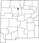
Los Alamos County, New Mexico Basics:


Los Alamos County New Mexico - Government Site

Population: 18,146
Area: 109 square miles
County seat: Los Alamos
Area code(s) in use: 505
Time zone: MST
High school graduate or higher: 97.4%
Bachelor's degree or higher: 63.2%
Median household income: $106,426
Persons in poverty: 4.9%
Home ownership rate: 77.0%
Mean travel time to work: 15.6 minutes


Adjacent counties:
Rio Arriba  Sandoval  Santa Fe  
Find in New Mexico

Map of the Los Alamos County area


Our detail map of Los Alamos County shows the Los Alamos County, New Mexico boundary lines and other interesting items.

Places in Los Alamos County, New Mexico

  Airports     show all on map

Los Alamos Airport

  Arches     show all on map

Phoenix Arch

  Benches     show all on map

Kwage Mesa, Otowi Mesa

  Buildings     show all on map

Bandelier National Monument Interagency Fire Base, Bradbury Science Museum, Fuller Lodge Art Center, Los Alamos Branch-UNM Learning Resource Center Library, Los Alamos County Historical Museum, Los Alamos County Historical Museum and Archives, Los Alamos County Library - Main Branch, Los Alamos County Library White Rock Branch, Los Alamos County Police Department, Los Alamos County Sheriff's Office, Los Alamos Fire Department Station 1, Los Alamos Fire Department Station 2 Training Facility, Los Alamos Fire Department Station 3, Los Alamos Fire Department Station 4, Los Alamos Fire Department Station 5, Los Alamos Fire Department Station 6, Los Alamos Medical Center Library, Los Alamos National Labratory Library, Los Alamos Technical Associates Library

  Cemeteries     show all on map

Guaje Pines Cemetery

  Census     show all on map

Los Alamos Census Designated Place, White Rock Census Designated Place

  Churches     show all on map

Ba'hai Faith Church, Bethlehem Evangelical Lutheran Church, Bethlehem Lutheran Church, Bryce Avenue Presbyterian, Bryce Avenue Presbyterian Church, Calvary Chapel, Calvary Chapel, Calvary Chapel, Christ Community Bible Church, Christ Community Bible Church, Christ Community Church, Christian Church, Christian Science Society Church, Church of Christ, Church of Christ, Church of the Nazarene, Church of the Nazarene La Vista, Community Evangelical Church, Community Evangelical Free Church, First Assembly of God Church, First Baptist Church, First Church of Christ Scientist, First United Methodist Church, Friends Religious Society of Quakers, Immaculate Heart of Mary Roman Catholic Church, Jehovah's Witness Church, La Vista Church of the Nazarene, Los Alamos Christian Fellowship Church, Messiah Evangelical Lutheran Church, Messiah Evangelical Lutheran Church, Sangre de Cristo Church, Seventh Day Adventist Church, The Christian Church, The Church of Jesus Christ of Latter Day Saints, The Church of Jesus Christ of Latter Day Saints, The Church of Jesus Christ of Latter Day Saints, The United Church of Los Alamos, Trinity Bible Church, Trinity Bible Church, Trinity on the Hill Episcopal Church, Unitarian Church, Unitarian Church, United Church, United Church of Los Alamos, White Rock Baptist Church, White Rock Baptist Church, White Rock Presbyterian Church, White Rock United Methodist Church, White Rock United Presbyterian Church, Whiterock Baptist Church

  Dams     show all on map

Los Alamos Ranch School Number One Dam

  Hospitals     show all on map

Los Alamos Medical Center

  Locales     show all on map

Bandelier Weather Station, Camp May Recreation Site, Central Shopping Center, Community Shopping Center, El Segundo Shopping Center, Frijoles, Guaje Historic Site, Juniper Campground, Los Alamos Scientific Laboratory, Los Alamos Weather Station, Mari Mac Village Shopping Center, Overlook Picnic Areas, Pajarito Acres, Pajarito Mountain Ski Area, Pine Spring Cabin, Pueblo of the Stone Lions, The Village Shopping Center, White Rock Shopping Center

  Parks     show all on map

Bandelier National Monument Historical Marker, Los Alamos Historical Marker, Pinon Park

  Populated Places     show all on map

Los Alamos, Upper Frijoles Crossing, White Rock

  Post Offices     show all on map

Los Alamos Post Office, Otowi Post Office (historical)

  Ranges     show all on map

Sierra de los Valles

  Rapidss     show all on map

Ancho Rapid

  Reservoirs     show all on map

Guaje Reservoir, Los Alamos Reservoir

  Schools     show all on map

Aspen Elementary School, Aspen School, Barranca Mesa Elementary School, Barranca School, Calvary Christian School, Canyoncito Montessori School, Canyoncito School, Chamisa Elementary, Covenant Christian School, Cumbres Junior High School, Hilltop Christian Academy, Los Alamos High School, Los Alamos Middle School, Los Alamos Ranch School, Mountain School, Pinon School, Pueblo Junior High, Sage Montessori School, University of New Mexico, University of New Mexico Los Alamos Branch

  Springs     show all on map

Alamo Spring, American Spring, Ancho Spring, Armstead Spring, Doe Springs, Los Utes Spring, Pajarito Spring, Pajarito Springs, Pine Spring, Sawyer Spring, Spring 3, Spring 3AA, Spring 4, Spring 5A, Spring 5B, Spring 7, Spring 8, Spring 9

  Streams     show all on map

Rito de los Frijoles

  Summits     show all on map

Barranca Mesa, Burnt Mesa, Escobas Mesa, Frijoles Mesa, Frijoles Mesa, Guaje Mountain, Mesita de Los Alamos, Mesita del Buey, Mesita del Potrillo, North Mesa, Pajarito Mesa, South Mesa, Threemile Mesa, Twomile Mesa

  Towers     show all on map

KNLA-FM (White Rock), KNLA-FM (White Rock), KNYN-FM (Santa Fe), KRBL-FM (Los Alamos), KRSN-AM (Los Alamos)

  Trails     show all on map

Agua Piedra Trail, Caballo Trail, Cabra Loop Trail, Capulin Trail, Guaje Canyon Trail, Guaje Ridge Trail, Los Alamos Canyon Trail, Mitchell Trail, Natural Arch Trail, Pajarito Canyon Trail, Pajarito Canyon Trail, Pajarito Trail, Quemazon Trail, Rendija Trail, Valle Trail, Water Canyon Trail

  Valleys     show all on map

Agua Piedra Canyon, Alamitos Canyon, Ancho Canyon, Cabra Canyon, Ca�ada Bonita, Ca�on de los Frijoles, Ca�on de Valle, Chaquehui Canyon, Fence Canyon, Los Alamos Canyon, Pajarito Canyon, Potrillo Canyon, Quemazon Canyon, Threemile Canyon, Twomile Canyon, Vallecito de los Caballos, Vallecitos Canyon, Water Canyon

  Wells     show all on map

01440 Water Well, 10253 Water Well, 10259 Water Well,

Los Alamos County, New Mexico Population By Race (2012 estimate)

RacePopulation
WhiteLos Alamos County White population 16,27716,276  
AsianLos Alamos County Asian population 1,1251,125
MixedLos Alamos County Mixed population 417417
American IndianLos Alamos County American Indian population 181181
BlackLos Alamos County Black population 127127
Hawaiian & Pacific IslanderLos Alamos County Hawaiian & Pacific Islander population 1818

Additional population tables :
State population table
New Mexico population by county