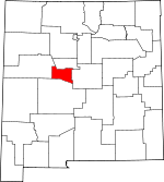
Valencia County, New Mexico Basics:
Valencia County New Mexico - Government Site
Population: 76,591
Area: 1066 square miles
County seat: Los Lunas
Area code(s) in use: 505
Time zone: MST
High school graduate or higher: 82.0%
Bachelor's degree or higher: 17.0%
Median household income: $42,525
Persons in poverty: 21.4%
Home ownership rate: 79.9%
Mean travel time to work: 29.0 minutes
Adjacent counties:
Bernalillo Cibola Socorro Torrance
Places in Valencia County, New Mexico
Alexander Municipal Airport,
Manzano-Mountain Air Ranch Airport,
Mid Valley Airpark,
Skywagon Farm Airport,
Valencia Community Air Ranch Kings Rest,
Los Valles Arroyo del Cuervo,
Caņada Ancha,
Caņada Colorada,
Hells Canyon Wash Atchison Topeka and Santa Fe Railroad Depot Historic Site,
Belen Fire Department Main Station,
Belen Fire Department Substation,
Belen Harvey House Historic Site,
Belen Hotel Historic Site,
Belen Police Department,
Belen Public Library,
Bosque Farms Community Library,
Bosque Farms Police Department,
Bosque Farms Volunteer Fire Department,
Central New Mexico Correctional Facility,
Central New Mexico Correctional Faciltiy Library,
Dust Bowl Home Historic Site,
Felipe Chaves House Historic Site,
Highland Meadows Volunteer Fire Department,
Huning Merchantile and House,
Immaculate Conception Parish Museum,
Jarales - Pueblitos Fire Department,
Living Cross Ambulance Service Belen,
Living Cross Ambulance Service Los Lunas,
Los Chavez Fire Department,
Los Lunas Community Library,
Los Lunas Correctional Center Library,
Los Lunas Fire Department Main Station,
Los Lunas Fire Department Substation,
Los Lunas Hospital and Training School (historical),
Los Lunas Police Department,
Manzano Vista Fire Department,
Meadow Lake Volunteer Fire Department,
Miguel E Baca House Historic Site,
New Mexico State Police District 5 Los Lunas,
Peralta Fire Department,
Rio Grande Estates Fire and Rescue Main Station,
Rio Grande Estates Fire and Rescue Teri Grande Substation,
Rural Bookmobile West,
Tome - Adelino Volunteer Fire Department Las Marivillas Station,
Tome - Adelino Volunteer Fire Department Main Station,
Tome Jail Historic Site,
University of New Mexico-Valencia Campus Library,
Valencia County Historical Society Museum,
Valencia County Sheriff's Office,
Valencia El Cerro Fire Department,
Valencia Presbyterian Hospital Library Arroyos Ditch,
Belen Highline Canal,
Belen Waste Ditch,
Bosque Drain,
Bosque Lateral,
Casa Colorada Canal,
Casa Colorada Ditch,
Casa Colorada Drain,
Cerro Drain,
Chical Ditch,
Chical Lateral,
El Cerro Ditch,
Gabaldon Drain,
Gabaldon Lateral,
Garcia Ditch,
Garcia Lateral Number 1,
Harlan Ditch,
Harlan Lateral,
Hells Canyon Drain,
Hells Canyon Wasteway,
Henderson Lateral,
Huning Lateral,
Jaral Ditch,
Jaral Lateral Number 1,
Jaral Lateral Number 2,
La Constancia Ditch,
La Constancia Lateral,
Las Cercas Ditch,
Los Chavez Ditch,
Los Chavez Drain,
Los Chavez Lateral,
Los Lentes Drain,
Los Lunas Ditch,
Los Lunas Wasteway,
Lower Belen Riverside Drain,
Lower Peralta Riverside Drain,
Lower Sabinal Riverside Drain,
Luna Drain,
Middle Ditch,
Middle Peralta Ditch,
New Belen Ditch,
New Jaral Ditch,
New Tome Ditch,
Old Belen Ditch,
Old Jarales Ditch,
Otero Drain,
Otero Lateral,
Peralta Ditch,
Peralta Main Canal,
Prison Lateral,
Sabinal Ditch,
Sabinal Lateral Number 2,
Sais Lateral,
San Fernandez Drain,
San Fernandez Lateral,
Sanchez Drain,
Sandhills Lateral,
Sausal Drain,
Tafoya Lateral,
Tome Ditch,
Tome Drain,
Upper Belen Riverside Drain,
Upper Peralta Riverside Drain,
Upper Sabinal Riverside Drain,
Upper San Juan Riverside Drain,
Valencia Ditch,
Valencia Drain,
Wittwer Lateral El Camposanto de la Liverta,
Los Lentes Cemetery,
Our Lady of Belen Cemetery,
Peralta and Valencia Cemetery,
Peralta Cemetery,
San Antonio de los Lentes Cemetery,
Sangre de Cristo Cemetery,
Spanish Methodist Cemetery,
Terrace Grove Cemetery,
Tome Cemetery Adelino Census Designated Place,
Casa Colorada Census Designated Place,
Chical Census Designated Place,
El Cerro Census Designated Place,
El Cerro Mission Census Designated Place,
El Cerro-Monterey Park Census Designated Place (historical),
Highland Meadows Census Designated Place,
Jarales Census Designated Place,
Las Maravillas Census Designated Place,
Los Chaves Census Designated Place,
Los Trujillos-Gabaldon Census Designated Place,
Madrone Census Designated Place,
Meadow Lake Census Designated Place,
Monterey Park Census Designated Place,
Peralta Census Designated Place (historical),
Pueblitos Census Designated Place,
Rio Communities Census Designated Place,
Rio Communities North Census Designated Place,
Sausal Census Designated Place,
Tome Census Designated Place,
Tome-Adelino Census Designated Place (historical),
Valencia Census Designated Place Belen Christian Church,
Belen Mennonite Church,
Bosque Farm Church,
Calvary Baptist Church,
Catholic Church of Tome,
Christ the King Lutheran Church,
El Cerro Church,
First Assembly of God Church,
First Asssembly of God Church,
First Baptist Church,
First Baptist Church of Los Lunas,
First Presbyterian Church,
Hosanna Assembly of God Church,
Los Lunas Christian Church,
Los Lunas Kingdom Hall of Jehovahs Witnesses,
Los Lunas Seventh Day Adventist Church,
Our Lady of Guadalupe Church,
Peralta Memorial United Methodist Church,
Saint Anthony Church,
Saint Phillips Episcopal Church,
San Clement Church of Los Lunas,
San Isidro Church,
Seventh Day Adventist Church Spanish,
Sierra Vista Baptist Church,
Valencia Church,
Valencia Valley Church,
Valley Baptist Church,
Valley Lutheran Church Belen North Interchange Acomita Reservoir Dam,
Ashcroft Reservoir Dam,
Badger Detention Dam,
Bibo Irrigation Dam,
Bluewater Dam,
Houston Arroyo Dam,
Isleta Diversion Dam,
Ojo Caliente Lake Dam,
Pronto Detention Dam,
Prop Canyon Site 2a Dam,
Prop Canyon Site One Dam,
San Mateo Lake Dam,
Seboyeta Irrigation System Dam,
Seis-Wilson Detention Dam Number 1,
Sohio L-Bar Tailings Dam,
T X Detention Dike Number 1,
T X Diversion Dam Number Three,
United Nuclear Homestakes Partners Dam,
Upper Boulder Detention Dam Salt Flats Las Huertas Ojo Lake, Ojo Salsa Lake
Antonio Sedillo Grant Headquarters,
Be-jui Tu-ay Historic Site,
Becker Coal Elevator,
Belen Weather Station,
Casa Colorado del Sur Historic Site,
Central New Mexico Correctional Facility,
Central New Mexico Correctional Honor Farm,
Chaves Place,
Chical Indian School, Chloe,
Comanche Ranch,
Commanche Trailhead,
Dead Cow Windmill,
El Paso Natural Gas Turbin Station,
Encino Trailhead, Felipe (historical), Ferry (historical),
Frost Ranch,
Garley Windmill,
John F Kennedy Campground,
Los Lentes Pueblo,
Los Lunas Weather Station,
Lower T X Ranch,
Lucero Windmill,
Marys Windmill,
McGaughys Windmill,
Millet Windmill,
Monte Largo Trailhead,
New Canyon Trailhead,
Popalito Windmill,
Pottery Mound,
Pueblo Casa Colorada Historic Site,
Pueblo Los Trujillos,
Pueblo Windmill,
Romero Ranch,
Romero Ranch,
Sais,
Salas Forest Service Facility,
San Juan Heading,
Shearing Corral Windmill,
Valencia Pueblo (historical),
Windmill Number 4 Fort Los Lunas (historical) All American Marble Claims, Audie Pit I.D.,
Belvidere Group,
El Cerro Pit,
Jack Rabbit Claim,
John Pit,
Lucero Quarry,
Milagros Mine,
Omission Quarry,
Orona Pit,
Romero,
Scholle Claim Group, Snyder Pit, South 125 Pit,
Tome Well Artistic Park,
Chester Skinner Park,
Cypress Estates Park,
Daniel Fernandez Memorial Park,
Enchantment Little League,
Heritage Park,
Los Lunas Sports Complex,
Peralta Historical Marker,
River Park,
Senator Willie M Chavez State Park,
Valley View Park,
Vasquez de Coronados Route Historical Marker Adelino,
Azul,
Bacaville,
Becker,
Belen,
Bodega,
Bosque,
Bosque Farms, Bosque Redondo,
Canyon del Rio,
Casa Colorada,
Chical,
Comanche Springs,
Correo, Cortez,
Dalies,
El Cerro, Esmeralda (historical),
Jarales,
La Constancia,
La Ladera,
La Ladera,
Las Maravillas,
Los Chavez,
Los Chavez, Los Gabaldones,
Los Lentes,
Los Lunas,
Los Trujillos,
Madrone, Manazana,
Meadow Lake, Mineral Springs (historical),
Mission Park,
Monterey Park, Otero (historical),
Paquita,
Pasitos del Cielo,
Peralta,
Pueblitos, Quelites (historical),
Rio Communities,
Rio del Oro,
Rio Grande Estates,
Rio Puerco, Rivera, San Blas (historical), San Clemente (historical), San Fernandez (historical), San Juan,
Sandia, Sauzal (historical),
South Garcia,
Suwanee, Tafoya (historical),
Tome,
Valencia Acomita Post Office (historical),
Adelino Post Office (historical),
Atarque Post Office (historical),
Bacaville Post Office (historical), Ballejos Post Office (historical),
Belen Post Office,
Bibo Post Office (historical),
Blue Water Post Office,
Bosque Post Office, Carr Post Office (historical),
Casa Blanca Post Office (historical),
Coppertown Post Office (historical),
Correo Post Office (historical),
Cubero Post Office,
Dalies Post Office (historical), De Vargas Post Office (historical),
Diener Post Office (historical), Esmeralda Post Office (historical),
Fence Lake Post Office, Ferry Post Office (historical), Gold Spring Post Office (historical),
Grants Post Office, Jalaroso Post Office (historical),
Jarales Post Office, Juantafoya Post Office (historical), Kettner Post Office (historical),
Laguna Post Office,
Los Chaves Post Office (historical),
Los Lunas Post Office,
Los Pinos Post Office,
Madrone Post Office (historical), Marquez Post Office (historical), McCartys Post Office (historical), Mineral Springs Post Office (historical),
New Laguna Post Office, Otero Post Office (historical),
Paguate Post Office, Paguate Post Office (historical), Palmer Ranch Post Office (historical),
Paxton Springs Post Office (historical),
Peralta Post Office, Publitos Post Office (historical),
San Fidel Post Office (historical),
San Mateo Post Office,
San Rafael Post Office,
Sawyer Post Office (historical), Schausten Post Office (historical),
Seama Post Office (historical),
Techado Post Office (historical),
Tingle Post Office (historical),
Tome Post Office, Trachado Post Office (historical),
Turn Post Office (historical),
Valencia Post Office (historical) Alderete Tank,
Badlands Tank,
Bartolo Trick Tank,
Brush Tank,
Casey Tank,
Click Tank,
Denison Tank,
Diego Tank,
East Tank,
East Tank,
El Grande Tank,
El Norte Tank,
Escondido Reservoir,
Esparauza Tank,
Gabaladon Reservoir,
Gabaldon Reservoir,
Gurule Tank,
Guzman Reservoir,
Heredura Tank,
House Tank,
La Lechusa Tank,
Mesa Hill Lake,
Metate Reservoir,
Middle Tank,
Middle Tank,
Middle Tank,
Monte Largo Tank,
North Tank,
Number 4 Tank,
Padilla Trick Tank,
Red Tank,
Rock Tank,
Sabina Tank,
Seboyeta Reservoir,
Shipping Tank,
Tank Number 11,
Tank Number 3,
Tank Number 7,
Target Reservoir,
Valentine Tank White Ridge Abundant Life Christian Academy,
Adelino School,
Ann Parish Elementary,
Ann Parish Elementary School,
Belen High School,
Bosque Farms Christian Academy,
Bosque Farms School,
Casa Colorada School,
Central Elementary School,
Daniel Fernandez Intermediate School,
Dennis Chavez Elementary School,
Desert View Elementary,
Gil Sanchez Elementary School,
Jaramillo Elementary School,
Katherine Gallegos Elementary School,
La Mesa Community School,
Los Lunas Elementary,
Los Lunas High School,
Los Lunas Middle School,
Mariposa Elementary,
Miracle Center School,
New Mexico Independent Academy,
Peralta Elementary School,
Peralta School,
Raymond Gabaldon Elementary School,
Rio Grande Elementary School,
Saint Mary School,
Tome Elementary School,
University of New Mexico Valencia Branch,
UNM Valencia Branch,
Valencia Elementary School Beehive Spring,
Berrendo Spring,
Bustamonte Spring,
Carrizo Spring,
Coyote Spring,
Dipping Vat Spring,
El Ojo Escondido,
La Casa Spring,
Laguna Pueblo Seeps,
Laguna Pueblo Springs, Lamb Spring,
Little Sand Spring,
Los Ojuelos,
Maes Spring,
Monte De Abajo Spring,
Monte Largo Spring,
Ojito Spring,
Ojo Alamo,
Ojo Barreras,
Ojo de la Cabra, Ojo de la Lomita,
Ojo Huelos,
Ojo Jedeondilla,
Ojo La Cabra,
Ojo Lemita, Ojo Lomito Trigo,
Ojo Salas,
Padilla Spring,
Pothole Spring,
Suwanee Spring, Trigo Spring,
Upper Monte Largo Spring,
Upper Ojo Barreras Spring,
YCC Spring Arroyo del Miranda,
Arroyo Garcia,
Arroyo Lucero,
Arroyo Monte Belen,
Arroyo Monte Largo,
Arroyo Pato,
Arroyo Salado,
Caņada de San Antonio,
La Canada de la Loma de Arena,
Rio San Jose,
Rock Creek Black Mesa,
Cat Mesa,
Cerro del Indio,
Chicken Mountain,
El Cerro De Los Lunas,
El Cerro Tome,
Hidden Mountain,
La Loma Alta,
Lomita Trigo,
Mesa Lucero,
Mesa Redonda,
Mesas Mojinas KARS-AM (Belen),
KARS-FM (Belen),
KARS-FM (Belen),
KZPY-FM (Los Lunas) Commanche Trail,
Jaral Trail,
Monte Largo Trail,
Mosca Trail,
New Canyon Trail,
Osha Trail,
Salas Trail,
Vigil Trail Caņon de Bartolo,
Caņon de Sanchez,
Canon del Sapo,
Caņon Monte de Abajo,
Caņon Monte Largo,
Comanche Draw,
Pipe Canyon,
Priest Canyon,
Sand Canyon 100009 Water Well,
10002 Water Well,
10003 Water Well,
10003 Water Well,
10004 Water Well,
10006 Water Well,
10007 Water Well,
10008 Water Well,
10010 Water Well,
10011 Water Well,
10012 Water Well,
10013 Water Well,
10014 Water Well,
10015 Water Well,
10016 Water Well,
10017 Water Well,
10018 Water Well,
10019 Water Well,
10020 Water Well,
10023 Water Well,
10024 Water Well,
10025 Water Well,
10026 Water Well,
10027 Water Well,
10028 Water Well,
10029 Water Well,
10030 Water Well,
10241 Water Well, Alto Water Well,
Dalies Oil Well,
Flack Well,
Grasslands Water Well,
J Maes Water Well, McGaughys Water Well,
Mesita Well,
Mountain Well,
North Well,
Popalito Water Well,
RG 16057-5-3 Water Well,
RG-18880-S-5 Water Well,
RG-27285 Water Well,
RG-28525 Water Well,
RG-39221 Water Well,
San Clemente Water Well,
Shell Water Well,
UN 1 Lot 1 Water Well,

