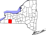
Allegany County, New York Basics:


Allegany County New York - Government Site

Population: 48,243
Area: 1029 square miles
County seat: Belmont
Area code(s) in use: 607 585
Time zone: EST
High school graduate or higher: 87.9%
Bachelor's degree or higher: 18.2%
Median household income: $42,095
Persons in poverty: 17.1%
Home ownership rate: 74.1%
Mean travel time to work: 21.2 minutes


Adjacent counties:
Cattaraugus  Livingston  McKean (PA)  Potter (PA)  Steuben  Wyoming  
Find in New York

Map of the Allegany County area


Our detail map of Allegany County shows the Allegany County, New York boundary lines and other interesting items.

Places in Allegany County, New York

  Airports     show all on map

Cuba Memorial Hospital Heliport, Dew Airpark, Erb Acres Airport, Houghton College Airport, Plane Haven Airport, Wellsville Municipal Airport (historical), Wellsville Municipal Airport, Tarantine Field

  Bays     show all on map

Arrowhead Bay

  Bridges     show all on map

Caneadea Bridge, Rush Creek Bridge, Transit Bridge, Weidrich Bridge

  Buildings     show all on map

Ade Dining Hall, Alfred Fire Department, Alfred Station Fire Company, Alfred University Science Center, Allentown Volunteer Fire Department, Alma Fire Department, Almond Town Hall, Almond Volunteer Fire Company and Ambulance, Alumni Hall, Amity Rescue Squad, Andover Free Library, Andover Volunteer Fire Department and Ambulance, Angelica Free Library, Angelica Hose Company 1, Arthur And Lea Powell Campus Center, Babcock Theatre, Barresi Hall, Bartlett Hall, Bartlett Memorial Library, Belfast Fire Department, Belfast Town Hall, Belmont Fire Department, Belmont Literary and Historical Society Free Library, Binns-Merrill Hall, Birdsall Fire Department, Bolivar Fire Department, Bolivar Free Library, Braddon Hall, Brick Residence Hall, Burdick Hall, Canaseraga Fire Company, Cannon Hall, Carnegie Hall, Centerville Memorial Volunteer Fire Department, Central Dining Hall, Chamberlain Center, Clarksville Ambulance Service, Colonial Library, Crandall Hall, Cuba Ambulance Service, Cuba Circulating Library, Cuba Fire Department, Cuba Village Garage, David A Howe Public Library, Davis Gymnasium, Duke Hose Company Fire Department, Dyke Street Engine Company Number 2, E J Brown Hall, Essential Club Free Library, Fancher Hall, Fiegl Maintenance Building, Fillmore Fire Department, Franklin W Olin Building, Friendship Ambulance Squad, Friendship Fire Department, Friendship Free Library, Genesee Public Library, Getman Hall, Gillette Hall, Greene Hall, Hall of Glass Science And Engineering, Harder Hall, Herrick Memorial Library, Highland Healthcare Center, Hinkle Memorial Library, Hotel Kinney (historical), Houghton College Center For The Arts, Houghton Volunteer Fire Department, Howell Hall, Hume Town Hall, Hunter Student Development Center, Huntington Administration Building, Independence Emergency Squad, Kanakadea Hall, Kirkpatrick Home For Childless Women (historical), Kruson Residence Hall, Lambein Hall, Luckey Building, MacKenzie Complex, Manor Hills, Marlin Miller Performing Arts Center, McLane Physical Education Center, McMahon Building, Medical Transport Service of Allegany County, Myers Hall, New Hudson Volunteer Fire Company, Nielsen Physical Education Center, Openhym Residence Hall, Oramel Fire Department, Orvis Activities Center, Paine Science Center, Pasquale Block, Peet Hall, Perlman Hall, Pioneer Center, Reimer Hall, Richburg Volunteer Fire Company, Robert R McComsey Career Development Center, Rothenbuhler Hall, Rushford Fire District Rescue Squad, Rushford Volunteer Fire Department, Saint James Hotel (historical), Scholes Library of Ceramics, Scio Free Library, Scio Volunteer Fire Company 1, Seidlin Hall, Shenawana Dormitory, Short Tract Fire Company, Shults Hall, Stevens Art Studio, Stull Observatory, Tefft Hall, The Waters of Houghton, Thornton Building, Twentieth Century Club Library, Village of Wellsville Water Works Pumping Station, Wellsville Fire Department, Wellsville Manor Care Center, Wellsville Municipal Building, Wellsville Student Activities Center, Wellsville Volunteer Ambulance Corps, Whitesville Fire Department, Whitesville Public Library, Wide Awake Club Library, William J Houghton Memorial Library, Willing Volunteer Hose Company 1, Wiscoy - Rossburg Volunteer Fire Company

  Canals     show all on map

Genesee Valley Canal

  Cemeteries     show all on map

Alfred Rural Cemetery, Alger Cemetery, Allen Cemetery, Allentown Cemetery, Bailey Hill Cemetery, Basswood Hill Cemetery, Bates Cemetery, Beech Hill Cemetery, Bellamy Cemetery, Bellville Cemetery, Black Cemetery, Black Creek Cemetery, Brewer Corners Cemetery, Burns Cemetery, Cadwell Corners Cemetery, Canaseraga Cemetery, Caneadea Cemetery, Centerville Cemetery, Chamberlain Cemetery, Christ Church Cemetery, Clarksville Cemetery, County Home Cemetery, County Line Cemetery, Cuba Cemetery, Dimmick Cemetery, Dyke Cemetery, East Caneadea Cemetery, East Valley Cemetery, East Valley Cemetery, Fairlawn Cemetery, Forest Hills Cemetery, Fulmer Valley Cemetery, Gate of Heaven Cemetery, German Settlement Cemetery, Graves Cemetery, Hallsport Cemetery, Hardys Corners Cemetery, Hillside Cemetery, Hillside Cemetery, Holy Cross Cemetery, Hume Village Cemetery, Independence Cemetery, Johnson Cemetery, Kenyon Road Cemetery, Knights Creek Cemetery, Lippincott Cemetery, Little Genesee Cemetery, Maple Grove Cemetery, Maple Lawn Cemetery, Maplewood Cemetery, Marshall Cemetery, Mount Hope Cemetery, Mount Pleasant Cemetery, Nile Cemetery, North Cuba Cemetery, Norton Cemetery, Old Burying Grounds, Our Lady of the Angels Catholic Cemetery, Palmer Cemetery, Phillips Creek Cemetery, Pine Grove Cemetery, Pioneer Cemetery, Podonque Cemetery, Richburg Cemetery, Riverside Cemetery, Rogers Cemetery, Rogers Cemetery, Rushford Cemetery, Sacred Heart Cemetery, Sacred Heart Cemetery, Saint Johns Cemetery, Saint Joseph's Cemetery, Saint Marys Cemetery, Saint Marys Cemetery, Saint Marys Cemetery, Sayers Cemetery, Short Tract Cemetery, Sortore Cemetery, Spring Mills Cemetery, Stannards Cemetery, Stillman Cemetery, Sunnyside Cemetery, Swain Cemetery, Trapping Brook Cemetery, United States Cemetery, Until The Day Dawn Cemetery, Utopia Cemetery, Valley Brook Cemetery, Weaver Settlement Cemetery, Well Cemetery, West Almond Cemetery, West Genesee Cemetery, Wheeler Cemetery, White Cemetery, White Cemetery, Whitesville Rural Cemetery, Wiscoy Cemetery, Woodlawn Cemetery, Woodlawn Cemetery, Yorks Corners Cemetery

  Census     show all on map

Belfast Census Designated Place, Fillmore Census Designated Place, Friendship Census Designated Place, Houghton Census Designated Place, Rushford Census Designated Place, Scio Census Designated Place, Stannards Census Designated Place

  Churches     show all on map

Abundant Life Ministries, Alfred Almond Bible Church, Alfred Seventh Day Baptist Church, Alfred Station Seventh Day Adventist Church, Andover First Baptist Church, Andover United Methodist Church, Angelica United Methodist Church, Belfast United Methodist Church, Bellville Church, Bellville Wesleyan Church, Belmont United Methodist Church, Birdsall Community Church, Blessed Sacrament Catholic Church, Bolivar United Methodist Church, Brookside Wesleyan Church, Calvary Baptist Church, Chenunda Creek Fellowship, Christ Church, Christ Episcopal Church, Christian and Missionary Church, East Caneadea Church, First Baptist Church, First Baptist Church, First Baptist Church, First Baptist Church, First Baptist Church of Hume, First Congregational Church, First Free Methodist Church, First Presbyterian Church, First Trinity Evangelical Church, First United Methodist Church, First United Methodist Church, Ford Brook Church, Friendship Bible Baptist Church, Friendship Church of God, Full Gospel Mission, Gardwoods United Methodist Church, Genesis Bible Church, Gospel Fellowship Church, Gospel Tabernacle, Gospel Tabernacle, Grace Episcopal Church, Grove Church, Holy Family Church, Houghton Wesleyan Church, Immaculate Conception Roman Catholic Church, Kingdom Hall of Jehovahs Witnesses, Kossuth Community Chapel, Masters Tabernacle Church, Nile Community Church, Our Lady of the Angels Roman Catholic Church, Rawson Church, Riverside Assembly of God, Saint Brendans Church, Saint John's Episcopal Church, Saint Josephs Church, Saint Jude's Center, Saint Mary's Church, Saint Patrick's Roman Catholic Church, Saint Patricks Church, Saint Pauls Church, Scio United Methodist Church, Seventh Day Adventist Church, Seventh Day Baptist Church, Shepherd of the Valley Lutheran Church, Southside Union Chapel, The Christian Temple, The Church of Jesus Christ of Latter Day Saints, Transit Bridge Church, Trinity First Evangelical Lutheran Church, United Church of Friendship, United Methodist Church of Cuba, Valley Wesleyan Church, Wellspring Ministries, Wellsville Full Gospel Church, Wellsville Presbyterian Church, Wesley Chapel, Wesleyan Church, Wesleyan Church, Wesleyan Methodist Church, West Clarksville Baptist Church, Wiscoy Baptist Church, World Mission Fellowship, Yorks Corners Mennonite Church

  Dams     show all on map

Caneadea Dam

  Gaps     show all on map

Clarksville Notch, East Notch, West Notch

  Hospitals     show all on map

Crandall Health Center, Cuba Memorial Hospital, Jones Memorial Hospital

  Lakes     show all on map

Ag-Tech Lake, Andover Pond, Beaver Lake, Hanging Bog, Jones Pond, Moss Lake, Palmers Pond, Paradise Lake, Rockville Lake, Spring Lake, Van Der Linden Pond

  Locales     show all on map

Alfred Wastewater Treatment Plant, Allegany County Landfill, Bainbridge Family Farm, Basswood Hill Farm, Belleigh Acres Hunt Club, Brandes Farms, Breezy Point Campground, Brentwood Camp, Brewer Corners, Cadwells Corners, Camp Harley, Camp Owaissa, Camp Rushford, Centre, Evergreen Golf Course, Evergreen Trails Campground, Fanton Farm, Farnum Hill Farm (historical), Five Corners, Francisco Farms, Friendship Rest Area, Granger, Graves Crossing, Hoffman Farms, Hyland Landfill, Jopo Farms, Kent Farms, Marcus Farms, Mariposa Ponds Campground, Mastin Corners, Neal Family Farm, Riverland Dairy Farms, Rocking R Farm, Speicher Farms, State Road, Stone Dam, Summit, Sunny Cove Farm, Val Dale Farms, Village of Wellsville Incinerator, Wellsville Country Club, Wellsville Sewage Treatment Plant, Wild Geese Farm, Wolf Creek Camp, Yardman Farm, York Corners

  Mines     show all on map

Alfred Pit, Almond Pit

  Parks     show all on map

Alfred Village Historic District, Angelica Park Circle Historic District, Canaseraga Four Corners Historic District, Chamberlain Park, Genesee Park, Hanging Bog Game Management Area, Hank Miller Memorial Field, Island Park, Main Street Historic District, Memorial Park, Merrill Field, Moraine Park, South Street Historic District, Tullar Field, Village Park

  Populated Places     show all on map

Alfred, Alfred Station, Allen Center, Allentown, Alma, Almond, Andover, Angelica, Aristotle, Balcom Beach, Belfast, Bellville, Belmont, Belvidere, Bennetts, Birdsall, Bishopville, Black Creek, Bolivar, Bowler, Burns, Canaseraga, Caneadea, Centerville, Ceres, Cuba, Dyke (historical), Elm Valley, Fairview, Fillmore, Friendship, Fulmer Valley, Garwoods, Gas Spring, Germantown, Grove, Hallsport, Hardy Corners, Higgins, Higgins, Hillcrest, Hiltonville, Hoben, Houghton, Hume, Inavale, Independence, Irish Settlement (historical), Karrdale, Knight Creek, Kossuth, Level Acres Mobile Home Park, Little Genesee, Lyons Corners, Mapes, Maple Grove Mobile Home Estates, Marshall, McGrawville, Mills Mills, Nile, North Almond, North Cuba, Norton Summit, Obi, Oramel, Paynesville, Petrolia, Phillips Creek, Pikeville, Rawson, Richburg, Riverside Mobile Home Park, Rockville, Rossburg, Rushford, Sanford, Sawyer, Sawyer Trailer Court, Scholes, Scio, Shongo, Short Tract, South Bolivar, South Cuba, Spring Mills, Stannards, Swain, Tinkertown, Tip Top, Valley View Estates, Vosburg, Wellsville, West Allen, West Almond, West Clarksville, West Notch, Whitesville, Wirt, Wiscoy, Withey

  Post Offices     show all on map

Alfred Post Office, Alfred Station Post Office, Allentown Post Office, Almond Post Office, Andover Post Office, Angelica Post Office, Belfast Post Office, Belmont Post Office, Black Creek Post Office, Bolivar Post Office, Canaseraga Post Office, Centerville Post Office, Ceres Post Office, Friendship Post Office, Little Genesee Post Office, Richburg Post Office, Scio Post Office, Wellsville Post Office, West Clarksville Post Office, Whitesville Post Office

  Reservoirs     show all on map

Amity Lake, Cuba Lake, Foster Lake, Rushford Lake, Saunders Pond

  Ridges     show all on map

Bow Ridge

  Schools     show all on map

Alfred State College Alfred Campus, Alfred State College Wellsville Campus, Alfred University, Alfred-Almond Central School, Andover School, Babcock School (historical), Black Creek School (historical), Bolivar - Richburg Elementary School, Bolivar - Richburg Junior - Senior High School, Brimmer Brook School (historical), Brooklyn Avenue Grade School (historical), Carnahan School (historical), Central School, Central School, Central School, Central School, Central School, Cooley School (historical), Corbin Hill School (historical), Cottrell School (historical), Cuba Elementary School, Cuba-Rushford Central School, Dimmick School (historical), Eastman School (historical), Ford Brook School (historical), Friendship Amish School, Friendship Central School, Genesee Valley Elementary School, Genesee Valley High School, Genesee Valley Middle School, Houghton Academy, Houghton College, Immaculate Conception School, Jersey Hill School (historical), Martin Street Public School (historical), Middaugh School (historical), Moulton School (historical), New Michigan School (historical), North Hill School (historical), Norton School (historical), Phillips Hill School (historical), Pine Grove School (historical), Pink School (historical), Pleasant Valley School (historical), Plum Bottom School (historical), School Number 1 (historical), School Number 1 (historical), School Number 1 (historical), School Number 1 (historical), School Number 10 (historical), School Number 12 (historical), School Number 12 (historical), School Number 13 (historical), School Number 13 (historical), School Number 17 (historical), School Number 2 (historical), School Number 2 (historical), School Number 2 (historical), School Number 2 (historical), School Number 2 (historical), School Number 2 (historical), School Number 3 (historical), School Number 3 (historical), School Number 3 (historical), School Number 3 (historical), School Number 3 (historical), School Number 4 (historical), School Number 4 (historical), School Number 4 (historical), School Number 4 (historical), School Number 4 (historical), School Number 4 (historical), School Number 4 (historical), School Number 4 (historical), School Number 4 (historical), School Number 5 (historical), School Number 5 (historical), School Number 5 (historical), School Number 5 (historical), School Number 5 (historical), School Number 5 (historical), School Number 5 (historical), School Number 5 (historical), School Number 5 (historical), School Number 6 (historical), School Number 6 (historical), School Number 6 (historical), School Number 6 (historical), School Number 6 (historical), School Number 6 (historical), School Number 6 (historical), School Number 7 (historical), School Number 7 (historical), School Number 7 (historical), School Number 7 (historical), School Number 7 (historical), School Number 7 (historical), School Number 8 (historical), School Number 8 (historical), School Number 8 (historical), School Number 9 (historical), School Number 9 (historical), School Number 9 (historical), School Number 9 (historical), Scio Central School, Scott Hollow School (historical), Scott School (historical), Shovel Hollow School (historical), Smalley School (historical), Thorntree School (historical), Valleyview Amish School, Washington School (historical), Wellsville Elementary School, Wellsville High School, Wellsville Middle School, White Hill School (historical), White School (historical), Whitesville Central School, Wirt Center School (historical)

  Springs     show all on map

Seneca Oil Spring

  Streams     show all on map

Ainsworth Brook, Angelica Creek, Baker Creek, Bells Brook, Bennett Creek, Black Creek, Black Creek, Black Creek, Brimmer Brook, Butternut Brook, California Creek, Canacadea Creek, Caneadea Creek, Chenunda Creek, Cold Creek, Cooley Creek, Crawford Creek, Crowner Brook, Cryder Creek, Deer Creek, Dodge Creek, Dry Brook, Dyke Creek, East Koy Creek, East Valley Creek, Elm Creek, Ewart Creek, Feathers Creek, Ford Brook, Foster Brook, Fry Creek, Gordon Brook, Griffin Creek, Hog Brook, Honeoye Creek, Horse Run, Indian Creek, Johnsons Creek, Karr Valley Creek, Knight Creek, Little Genesee Creek, Long Gore Creek, Marsh Creek, Marsh Creek, McHenry Valley Creek, Moss Brook, North Branch Phillips Creek, North Branch Van Campen Creek, Orebed Creek, Phillips Creek, Plum Bottom Creek, Put Brook, Railroad Brook, Rawson Creek, Redwater Creek, Rush Creek, Rush Creek, Shongo Creek, Sixtown Creek, Slader Creek, Snowball Hollow Creek, South Branch Ford Brook, South Branch Van Campen Creek, Spring Mills Creek, Tannery Creek, Trapping Brook, Van Campen Creek, Vandermark Creek, Wahl Brook, West Branch Creek, West Branch Van Campen Creek, White Creek, Wigwam Creek, Wileyville Creek, Willow Brook, Windfall Creek, Wiscoy Creek, Wolf Creek

  Summits     show all on map

Alma Hill, Bald Mountain, Beebe Hill, Beech Hill, Ben Socker Hill, Bliven Hill, Cuba Hill, East Hill, Grunder Hill, Hamilton Hill, Hanover Hill, Isaman Hill, Jackson Hill, Jacobs Hill, Jericho Hill, Jersey Hill, Johnson Hill, Jordan Hill, Lattimer Hill, Meservey Hill, Miller Hill, North Hill, Oak Hill, Peacock Hill, Pennsylvania Hill, Pine Hill, Pingry Hill, Rauber Hill, Reservation Hill, Richburg Hill, Round Top, Roundtop, Sand Hill, South Hill, Swift Hill, Tildon Hill, Vorhees Hill, White Hill

  Swamps     show all on map

Keaney Swamp

  Towers     show all on map

Davis Memorial Carillon, WALF-FM (Alfred), WCID-FM (Friendship), WETD-FM (Alfred), WJQZ-FM (Wellsville), WJSL-FM (Houghton), WLSV-AM (Wellsville)

  Valleys     show all on map

Anderson Hollow, Bear Valley, Bee Hollow, Belle Hollow, Best Hollow, Bradford Hollow, California Hollow, Christian Hollow, Coon Hollow, Cordory Hollow, Courtney Hollow, Dodge Hollow, Doget Hollow, Duffy Hollow, Dutton Hollow, Elm Valley, Fiftythree Hollow, Foreman Hollow, Fulmer Valley, Gadsby Hollow, Hovey Gully, Hunt Creek, Kansas Hollow, Mead Hollow, Miller Hollow, Narvoo Hollow, Nineteen Gully, Pleasant Valley, Poags Hole, Quig Hollow, Rawson Valley, Scott Hollow, Shovel Hollow, Skunk Hollow, Smith Hollow, Spring Hollow, Stony Lonesome Hollow, Wightman Hollow, Wilson Hollow,

Allegany County, New York Population By Race (2012 estimate)

RacePopulation
WhiteAllegany County White population 46,41046,409  
BlackAllegany County Black population 627627
MixedAllegany County Mixed population 579578
AsianAllegany County Asian population 482482
American IndianAllegany County American Indian population 145144
Hawaiian & Pacific IslanderAllegany County Hawaiian & Pacific Islander population 00

Additional population tables :
State population table
New York population by county