Chenango County, New York Basics:


Chenango County New York - Government Site

Population: 49,904
Area: 894 square miles
County seat: Norwich
Area code(s) in use: 607 315
Time zone: EST
High school graduate or higher: 85.5%
Bachelor's degree or higher: 16.8%
Median household income: $44,127
Persons in poverty: 14.6%
Home ownership rate: 76.0%
Mean travel time to work: 22.5 minutes
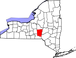
Adjacent counties:
Broome  Cortland  Delaware  Madison  Otsego  

Find in New York

Map of the Chenango County area


Our detail map of Chenango County shows the Chenango County, New York boundary lines and other interesting items.

Places in Chenango County, New York

  Airports     show all on map

Greene Airport, Lt Warren Eaton Airport, Miller Field Airport, Morin Airport, North Fork Airport, Sidney Municipal Airport, Tri County Airways Airport

  Bridges     show all on map

Ditch Road Bridge, State Street Bridge, Unadilla River Bridge

  Buildings     show all on map

Afton Fire Department, Afton Free Library, Bainbridge Fire Department, Bainbridge Free Library, Borden Hose Company 1 Mount Upton Station, Borden Hose Company 1 Rockdale Station, Brisben Fire Department House, Chenango County Court House, Chenango County Historical Society, Chenango County Home Preston Manor, Chenango County Office Building, Chenango Memorial Hospital Residential Health Care Facility, Chenango Valley Home For Aged Women, Colonia Theatre, Coventry Volunteer Fire Company, Dakin Opera House (historical), Genegantslet Volunteer Fire Company, Grace View Manor Assisted Living Facility, Greene Emergency Squad, Greene Town Hall, Greene Volunteer Fire Department, Guernsey Homestead Memorial Library, Guilford Volunteer Fire Department, McDonough Fire Department, Moore Memorial Library, New Berlin Fire Department, New Berlin Library, New Berlin Municipal Building, New Eagle Hotel (historical), New York State Veterans Home of Oxford, North Norwich Fire Department, Norwich City Hall, Norwich Club, Norwich Fire Department, Oxford Fire Department, Oxford Memorial Library, Pearl and Everett Gilmour Health Care Facility, Pharsalia Fire Company, Plymouth Fire District Volunteer Fire Department, Pratt - Newton Memorial Home, Preston Volunteer Fire Department, Sherburne Municipal Building, Sherburne Public Library, Sherburne Senior Housing Center, Sherburne Town Fire Department, Smyrna Public Library, Smyrna Volunteer Fire Department, South New Berlin Free Library, South New Berlin Volunteer Fire Department, South Otselic Volunteer Fire Department, United Methodist Homes Doris L Patrick Campus, Valley View Manor Nursing Home, Womans Relief Corps Home

  Cemeteries     show all on map

Amblerville Cemetery, Ashcraft Cemetery, Baptist Cemetery, Barnes Cemetery, Beardsley Cemetery, Bennettsville Cemetery, Blackman Cemetery, Bloom Cemetery, Bonney Cemetery, Brakel Valley Churchyard Cemetery, Brisben Baptist Church Cemetery, Brooks Cemetery, Campbell Cemetery, Carter School House Cemetery, Church Hollow Cemetery, Cole Hill Cemetery, Columbus Center Cemetery, Columbus Corners Cemetery, Cooper Cemetery, Corbin Cemetery, Coventry Union Cemetery, Coventryville Cemetery, Cowles Cemetery, Crane Cemetery, Curtiss Cemetery, Dyer Cemetery, East Guilford Cemetery, East Hill Cemetery, East Pharsalia Cemetery, Eastside Cemetery, Edmonds Cemetery, Elliot Cemetery, Evergreen Cemetery, Fairview Cemetery, Foote Cemetery, Frink Cemetery, Genegantslet Cemetery, Glenwood Cemetery, Godfrey's Corners Cemetery, Gospel Hill Cemetery, Greenlawn Cemetery, Guilford Center Cemetery, Guy Cemetery, Harris Cemetery, Harrisville Cemetery, Heady Cemetery, Hinman Cemetery, Holmesville Burying Ground, Horton Cemetery, Howard Cemetery, Ives Settlement Cemetery, Kings Settlement Cemetery, Kirk Cemetery, Knickerbocker Cemetery, Lewis Cemetery, Lincklaen Center Cemetery, Loomis Cemetery, Lower Genegantslet Cemetery, Maple Grove Cemetery, Maple Grove Cemetery, Maplewood Cemetery, Mason-Packer Cemetery, Mead Cemetery, Melondy Hill Cemetery, Millbrook Cemetery, Miller Cemetery, Moore Cemetery, Moore Cemetery, Morse Cemetery, Mount Hope Cemetery, New York State Veterans Home Cemetery, North Afton Cemetery, North Canal Street Cemetery, North Cemetery, North Norwich Cemetery, North Pitcher Cemetery, North Side Cemetery, North West Corners Cemetery, Norwich Cemetery, Oak Grove Cemetery, Old Chapel Cemetery, Packer-Mason Cemetery, Palmer Cemetery, Pearsall Cemetery, Perkins Cemetery, Pharsalia Center Cemetery, Pink Cemetery, Pitcher Congregational Church Cemetery, Plasterville Cemetery, Pond Cemetery, Presbyterian Cemetery, Quarter Cemetery, Reynolds Cemetery, Rhode Island Cemetery, Riverside Cemetery, Riverview Cemetery, Rogers Cemetery, Rounds Cemetery, Saint Andrew's Cemetery, Saint Joseph's Cemetery, Saint Malachy Cemetery, Saint Pauls Cemetery, Scribner Cemetery, Seventh Day Hollow Cemetery, Sherburne West Hill Cemetery, Slater Cemetery, Smithville Flats Cemetery, Smyrna East Cemetery, Soper Cemetery, South Plymouth Cemetery, Southside Cemetery, Stafford Cemetery, State Street Cemetery, Stover Cemetery, Ten Broeck Cemetery, Tillotson Cemetery, Ufford Cemetery, Union Cemetery, Upper Page Brook Cemetery, Valley View Cemetery, Van Wagenen Cemetery, West Bainbridge Cemetery, West End Cemetery, Westview Cemetery, Wightman Cemetery, Wilcok Cemetery, Wilcox Cemetery, Woodlawn Cemetery, Wylie Cemetery, Yaleville Cemetery

  Census     show all on map

Guilford Census Designated Place, Smithville Flats Census Designated Place

  Churches     show all on map

Afton Presbyterian Church, Afton United Methodist Church, Agape Baptist Church, Assembly of God Church, Bainbridge Methodist Church, Berean Baptist Church, Berean Bible Church, Bethel Church (historical), Brakel Church (historical), Brisben Baptist Church, Broad Street Methodist Church, Calvary Baptist Church, Calvary Baptist Church, Central Baptist Church, Christ Episcopal Church, Christ Lutheran Church, Christian Baptist Church, Christian Missionary Alliance, Church of the Nazarene, Community Bible Fellowship, Crossroads Community Church, Emmanuel Episcopal Church, Faith Bible Church, First Baptist Church, First Baptist Church, First Baptist Church, First Baptist Church, First Baptist Church, First Baptist Church, First Congregational Church, First Congregational Church, First Congregational Church, First Congregational Church, First Congregational Church, First United Methodist Church, Free Methodist Church, Grace Christian Fellowship, Greene Assembly of God, Guilford United Methodist Church, Higher Ground Christian Church, Hope Congregational Church, Immaculate Conception Church, Kingdom Hall of Jehovahs Witnesses, Little White Church, Negro Hollow Church, New Beginnings Church, North Afton Methodist Church, Norwich Jewish Center, Oxford - McDonough United Methodist Church, Oxford Baptist Church, Saint Agnes Catholic Church, Saint Andrew's Episcopal Church, Saint Anns Episcopal Church, Saint Bartholomew's Roman Catholic Church, Saint John's Catholic Church, Saint Joseph's Roman Catholic Church, Saint Malachy's Roman Catholic Church, Saint Paul's Roman Catholic Church, Saint Pauls Episcopal Church, Saint Peters Episcopal Church, Saint Theresa's Roman Catholic Church, Seventh Day Adventist Church, Sherburne Baptist Church, Sherburne United Methodist Church, Smyrna Baptist Church, Smyrna United Methodist Church, Temple Baptist Church, The Church of Jesus Christ of Latter Day Saints, The Church of Jesus Christ of Latter Day Saints, Union Church, United Methodist Church, West Bainbridge Baptist Church, West Smyrna Baptist Church, Zion Episcopal Church

  Falls     show all on map

Rexford Falls, White Store Falls

  Forests     show all on map

Chenango State Forest

  Hospitals     show all on map

Chenango Memorial Hospital

  Islands     show all on map

Balls Island

  Lakes     show all on map

Afton Lake, Ashcraft Pond, Bliven Pond, Borden Pond, Brackett Lake, Chenango Lake, Cincinnatus Lake, Echo Lake, Echo Lake, Genegantslet Lake, Guilford Lake, Hunt Pond, Jackson Pond, Jam Pond, Knapp Pond, Lake Gerry, Lake Ludlow, Lake Petonia, Long Pond, Madison Pond, McCall Pond, Mead Pond, Mud Pond, North Pond, Roberts Pond, Round Pond, Round Pond, Sears Pond, Smith Pond, Steer Pond, Taft Pond, Tank Pond, Truitt Pond, Van Valkenburgh Pond, Warn Lake, Whites Pond

  Locales     show all on map

Afton Golf Club, Alishauskas Dairy, Bainbridge Business Park, Barnes Corners, Blue Stone Golf Course, Burwell Corners, Canasawacta Golf and Country Club, Chenango County Landfill, Chenango Valley Ranch, Cooper Corners, Coventry Station, Fairkit Farm, Genegantslet Golf Club, German Five Corners, Godfrey Corners, Heller's Farm, Hidden Ponds Stables, High Bridge, High Meadow Farm, Hopestead Hill Farm, Ingraham Corners, Johnson Corners, Johnson Farms, Kings Settlement, Lambs Corners, Lambs Quarters Organic Farm, Many Maples Farm, Marstan Farms, Millers Corners, Mountain Top Golf Course, North Guilford Corners, Northrups Corners, Nortons Corners, Norwich Drive-In (historical), Oxford Station, Puckerville Corners, Riverbend Golf Course, Rogers State Game Farm, Sacketts Harbor, Shadyside Farm, Sherburne Grange, Stuart Corners, Tall Pines Riverfront Campground, The New Echo Lake Resort, Trestle Corners, Ufford Corners, Waldron Corners, Walker Corners, Waltzing Horse Farm, Webb Corners, Wilcox Corners, Windsor Corners, Woods Corners

  Parks     show all on map

East Park, Hunt's Pond State Park, Peacock Park, Pharsalia Game Refuge, Washington Park, West Park

  Pillars     show all on map

Gibson Pinnacle

  Populated Places     show all on map

Adams Corner, Afton, Amblerville, Bainbridge, Beaver Meadow, Bennettsville, Bettsburg, Blackesley Corner, Bonney, Brisben, Buckley Hollow, Button City, Chenango Lake, Columbus, Columbus Quarter, Corbin Corner, Coventry, Coventryville, Davis Crossing, Dibble Corner, East Afton, East Guilford, East McDonough, East Pharsalia, Fickles Corner, Five Corners, Galena, Genegantslet, German Four Corners, Greene, Guilford, Guilford Center, Harrisville, Hawley Corners, Haynes, Holmesville, Hydeville, Ives Settlement, Kelsey Brook Trailer Court, Kirk, Lakeview, Lakeville, Lathams Corners, Lincklaen, Lincklaen Center, Lower Genegantslet Corner, Maple Grove East, Mariposa, McDonough, Middle Bridge, Mount Upton, New Berlin, Nineveh Junction, North Afton, North Norwich, North Pharsalia, North Pitcher, Northwest Corners, Norwich, Otselic, Otselic Center, Oxford, Page Brook, Parker, Pharsalia, Pinewoods Mobile Home Park, Pitcher, Pitcher Springs, Plasterville, Plymouth, Polkville, Preston, Preston Center, Rhode Island, Rockdale, Rockwells Mills, Sages Crossing, Seventh Day Hollow, Sherburne, Sherburne Four Corners, Smithville Center, Smithville Flats, Smyrna, South New Berlin, South Otselic, South Oxford, South Plymouth, Springvale, Stanbro, Sweets, Tallette, Tyner, Union Valley, Upperville, Valley View Mobile Home Park, West Bainbridge, White Store, Yaleville

  Post Offices     show all on map

Afton Post Office, Bainbridge Post Office, Guilford Post Office, McDonough Post Office, Norwich Post Office, Oxford Post Office, Plymouth Post Office, Sherburne Post Office, Smithville Flats Post Office, Smyrna Post Office, South New Berlin Post Office, South Plymouth Post Office

  Reservoirs     show all on map

Bainbridge Reservoir, Deer Pond, Perkins Pond, Plymouth Reservoir, Sidney Reservoir, Trestle Lake

  Ridges     show all on map

Tinker Ridge

  Schools     show all on map

Afton Elementary School, Afton Middle - High School, Bainbridge - Guilford High School, Central School, Greene High School, Greene Intermediate School, Greene Middle School, Greene Primary School, Greenlawn Elementary School, Guilford Elementary School, Lane School (historical), Mariams School, New Berlin Central School (historical), Norwich High School, Norwich High School (historical), Norwich Middle School, Otselic Valley Junior - Senior High School, Oxford Academy And Central School, Oxford Academy High School, Oxford Academy Primary School, Perry Browne Intermediate School, Pond School (historical), Red School (historical), Saint Pauls Parochial School, School Number 1 (historical), School Number 1 (historical), School Number 1 (historical), School Number 1 (historical), School Number 1 (historical), School Number 1 (historical), School Number 1 (historical), School Number 1 (historical), School Number 1 (historical), School Number 10 (historical), School Number 10 (historical), School Number 11 (historical), School Number 11 (historical), School Number 11 (historical), School Number 12 (historical), School Number 12 (historical), School Number 12 (historical), School Number 13 (historical), School Number 13 (historical), School Number 13 (historical), School Number 14 (historical), School Number 15 (historical), School Number 16 (historical), School Number 2 (historical), School Number 2 (historical), School Number 2 (historical), School Number 2 (historical), School Number 2 (historical), School Number 2 (historical), School Number 24 (historical), School Number 3 (historical), School Number 3 (historical), School Number 3 (historical), School Number 3 (historical), School Number 3 (historical), School Number 4 (historical), School Number 4 (historical), School Number 4 (historical), School Number 4 (historical), School Number 4 (historical), School Number 4 (historical), School Number 5 (historical), School Number 5 (historical), School Number 5 (historical), School Number 5 (historical), School Number 6 (historical), School Number 6 (historical), School Number 6 (historical), School Number 6 (historical), School Number 6 (historical), School Number 6 (historical), School Number 6 (historical), School Number 7 (historical), School Number 7 (historical), School Number 7 (historical), School Number 7 (historical), School Number 8 (historical), School Number 8 (historical), School Number 9 (historical), School Number 9 (historical), School Number 9 (historical), School Number 9 (historical), Sherburne - Earlville Elementary School, Sherburne - Earlville Middle School, Sherburne Central School, Sherburne-Earlville High School, Stanford J Gibson Primary School, Town School Number 3, Town School Number 9, Unadilla Valley Central School, Valley Heights Christian Academy, Ward School Number 1 (historical), Ward School Number 2 (historical), Ward School Number 3 (historical), Ward School Number 4 (historical), Ward School Number 5 (historical), Windham School

  Streams     show all on map

Alder Meadow Brook, Ashbell Brook, Balsam Creek, Bear Brook, Beaver Creek, Bennettsville Creek, Birdsall Brook, Bowman Creek, Bucks Brook, Bumps Creek, Canasawacta Creek, Center Brook, Chalker Creek, Cheshire Creek, Clark Creek, Coit Brook, Cold Brook, Cold Spring Brook, Cole Brook, Cookhouse Creek, Crooked Brook, East Branch Canasawacta Creek, Eddy Brook, Edgerton Brook, Five Streams, Fly Creek, Fly Meadow Creek, Forty Brook, Genegantslet Creek, Gilmore Brook, Glading Brook, Glen Brook, Glen Road Brook, Great Brook, Guilford Creek, Handsome Brook, Hawley Brook, Indian Brook, Johnson Creek, Kedron Brook, Kelsey Creek, Kent Brook, Landers Creek, Ludlow Creek, Lyon Brook, Mad Brook, Mann Brook, Masonville Creek, Middletown Brook, Mill Brook, Mill Brook, Moses Brook, Mud Creek, Mud Pond Creek, Newton Brook, Number Six Brook, Osborn Brook, Padget Brook, Peckham Brook, Peppermint Brook, Pleasant Brook, Pleasant Brook, Pond Brook, Ransford Creek, Red Brook, Reed Creek, Reservoir Creek, Sangerfield River, Shapley Brook, Shawler Brook, South Lebanon Brook, Spring Brook, Strongs Brook, Tallette Creek, Thompson Brook, Thompson Creek, Tillotson Creek, Turner Creek, West Branch Great Brook, West Brook, Whapanaka Brook, Wheeler Brook, White Store Brook, Wilkins Brook, Willey Brook, Wylie Brook, Yaleville Brook

  Summits     show all on map

Bailey Hill, Berry Hill, Bobell Hill, Bolster Hill, Bradley Hill, Breffel Hill, Buck Hill, Burdick Hill, Burnt Hill, Camels Hump, Cary Hill, Church Hill, Cohoon Hill, Cole Hill, Columbus Hill, Dingman Hill, Dunmore Hill, East Juliand Hill, Flagpole Hill, Gamble Roof Hill, Gospel Hill, Harbor Hill, Hunts Mountain, Juliand Hill, Keater Hill, Kenyon Hill, Lane Hill, Meeker Hill, Midland Hill, Miller Hill, Mount Arm, Mount Pisgah, Mount Pleasant, Mowry Hill, Neff Hill, Negro Hill, Oak Hill, Painter Hill, Parce Mountain, Perkins Hill, Pigeon Hill, Pink Hill, Pleasant Hill, Purdy Hill, Roys Hill, Shumway Hill, Silas Hill Mountain, Skinner Hill, South Hill, South Hill, Squirrel Hill, Steam Sawmill Hill, Sugarloaf Mountain, Truman Hill, Wagner Hill, Watrous Hill, West Hill, Winchell Hill

  Swamps     show all on map

Brown Swamp, Corbin Swamp, Curtis Swamp, Dunn Swamp, Hopkins Swamp, Loomis Swamp, Neiding Swamp, Smith Swamp, Spruce Swamp, Tamarack Swamp, Turk Slashings, Wittling Swamp

  Towers     show all on map

WCHN-AM (Norwich), WKXZ-FM (Norwich)

  Valleys     show all on map

Chenango Valley, Dark Hollow, German Hollow, Negro Hollow,

Chenango County, New York Population By Race (2012 estimate)

RacePopulation
WhiteChenango County White population 48,40748,406  
MixedChenango County Mixed population 649648
BlackChenango County Black population 399399
AsianChenango County Asian population 250249
American IndianChenango County American Indian population 200199
Hawaiian & Pacific IslanderChenango County Hawaiian & Pacific Islander population 00

Additional population tables :
State population table
New York population by county