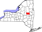
Fulton County, New York Basics:


Fulton County New York - Government Site

Population: 55,002
Area: 495 square miles
County seat: Johnstown
Area code(s) in use: 518 315
Time zone: EST
High school graduate or higher: 84.8%
Bachelor's degree or higher: 14.5%
Median household income: $45,333
Persons in poverty: 16.5%
Home ownership rate: 69.6%
Mean travel time to work: 22.5 minutes


Adjacent counties:
Hamilton  Herkimer  Montgomery  Saratoga  
Find in New York

Map of the Fulton County area


Our detail map of Fulton County shows the Fulton County, New York boundary lines and other interesting items.

Places in Fulton County, New York

  Airports     show all on map

Carpet City Airport (historical), Dolgeville Airport, Fulton County Airport, Hart Airport, Johnson Airport, Longwell Airport, Murphys Landing Strip, The Farm Airport, The Pines Airport, Wenskoski Field Airport

  Areas     show all on map

East Caroga Lake Camping Area

  Benches     show all on map

Bellan Ledge

  Buildings     show all on map

Ambulance Service of Fulton County, Arietta Building, Berkshire Fire District, Broadalbin Kennyetto Fire Department, Broadalbin Kennyetto Volunteer Fire Company, Broadalbin Volunteer Ambulance Corps, Caroga Lake Volunteer Fire Department, Central Nursing Home, Chrissy's Greenhouses, David and Helen Getman Memorial Home, Ephratah Volunteer Fire Department, Forest Hill Tower, Fulton County Court House, Fulton County Jail, Fulton County Office Building, Fulton County Residential Health Care Facility, Glove Theatre, Gloversville City Hall, Gloversville Fire Department, Gloversville Fire Station Number 2, Gloversville Fire Station Number 3, Gloversville Free Library, Hilltop Volunteer Fire Company, Johnstown Area Volunteer Ambulance Corps, Johnstown City Hall, Johnstown Fire Department, Johnstown Fire Station Number 2, Johnstown Public Library, Johnstown Town Hall, Lassellsville Fire House Volunteer Company, Mayfield Fire District 2, Mayfield Municipal Office, Meco Volunteer Fire Department, Nathan Littauer Hospital Nursing Home, Northampton Town Office, Northville Fire Department, Northville Northampton Ambulance Service, Oppenheim Volunteer Fire Company 1, Patti's Greenhouses, Perth Volunteer Fire Company, Pineview Commons Home for Adults, Rockwood - Garoga - Lassellsville Volunteer Fire Company Station 2, Rockwood Fire House, Saint Anthony Hall, Sampsonsville Volunteer Fire Department, Sir William Johnson Volunteer Fire Company, Sir William Johnson Volunteer Fire Department, Stratford Volunteer Fire Department, Towne Theater (historical), Tryon Secure Center for Girls, Wells House, Wells Nursing Home, Willing Helpers Home for Old Ladies (historical), Windsor Building

  Capes     show all on map

Dolgeville Point, Hampton Point, Kunkel Point, Paradise Point, Point Breeze, Sandy Point, Sinclaire Point, Vandenburgh Point

  Cemeteries     show all on map

Berry Cemetery, Bleecker Center Cemetery, Bleeker Cemetery, Boshart Cemetery, Brown Cemetery, Chatsey Cemetery, Christie Cemetery, Christman Cemetery, Clemmons Cemetery, Colonial Cemetery, Dempster Cemetery, Dillaborough Cemetery, Dutch Reformed Church Cemetery, Ephratah Rural Cemetery, Ferndale Cemetery, Fical Cemetery, Five Point Cemetery, Getman Cemetery, Gifford Valley Cemetery, Hageman Cemetery, Israel Cemetery, Kecks Center Cemetery, Main Street Cemetery, Mayfield Cemetery, McBeth Cemetery, Micheal Cemetery, Middlesprite Cemetery, Mount Carmel Cemetery, Munsonville Cemetery, Perth Cemetery, Prospect Hill Cemetery, Prospect Hill Cemetery, Rhodes Cemetery, Riceville Cemetery, Rockwood Rural Cemetery, Roundtop Cemetery, Saint Anthonys Cemetery, Saint Bridgett's Cemetery, Saint Johns Cemetery, Saint Josephs Cemetery, Saint Patricks Cemetery, Smith Cemetery, Union Mills Cemetery, Vail Mills Cemetery, Village Cemetery, West Galway Cemetery, Yates Cemetery, Zion Hill Cemetery

  Census     show all on map

Caroga Lake Census Designated Place

  Churches     show all on map

Adirondack Baptist Church, Baptist Church of Northville, Bible Baptist Church, Bible Truth Hall, Bleecker Street Church of Christ, Broadalbin Baptist Church, Broadalbin United Methodist Church, Christ Lutheran Church, Church of the Immaculate Conception, Church of the Nazarene, Covenant Presbyterian Church, Emmanuel Baptist Church, Faith Tabernacle, First Baptist Church, First Baptist Church, First Church of Christ Scientist, First Congregational Church, First Free Methodist Church of Gloversville, First Methodist Church, First Methodist Church, First Presbyterian Church, First Presbyterian Church, First Presbyterian Church, First Reformed Church, First United Methodist Church of Northville, Foothills United Methodist Church, Free Methodist Church, Fulmont Community Church, Gateway Pentecostal Church, Johnstown Church of Christ, Kingsboro Assembly of God, Kingsboro Presbyterian Church, Knesseth Israel Synagogue, Living Hope Church, New Covenant Community Church, North Bush Church (historical), North Main Street Methodist Church, Northampton United Methodist Church, Northville Presbyterian Church, Our Lady of Mount Carmel Roman Catholic Church, Pilgrim Holiness Church (historical), Sacred Heart Roman Catholic Church, Saint Anthonys Church, Saint Barbaras Chapel, Saint Basils Church, Saint Francis Church, Saint Francis De Sales Roman Catholic Church, Saint James Lutheran Church, Saint James Lutheran Church, Saint John's Episcopal Church, Saint Josephs Church, Saint Mary's Roman Catholic Church, Saint Patrick's Roman Catholic Church, Saint Paul's Lutheran Church (historical), Seventh Day Adventist Church, The Church of Jesus Christ of Latter Day Saints, Trinity Anglican Episcopal, Trinity Episcopal Church, Wesleyan Church

  Falls     show all on map

Buttermilk Falls

  Hospitals     show all on map

Johnstown Hospital, Littauer Hospital (historical), Nathan Littauer Hospital

  Islands     show all on map

Beacon Island, Kenyon Islands, Mead Island, Sand Island, Scout Island, Stoner Island

  Lakes     show all on map

Ash Pond, Ayers Lake, Bellows Lake, Broomstick Lake, Cameron Reservoir, Canada Lake, Caroga Lake, Chase Lake, Conglin Lakes, County Line Lake, Dexter Lake, East Caroga Lake, Eastman Lake, Fisher Vly Lake, Fourth Lake, Goose Egg Lake, Green Lake, Hillabrandt Vly, Hines Pond, Holmes Lake, House Pond, Indian Lake, Knapps Long Lake, Lily Lake, Little Chub Lake, Little Holmes Lake, Little Oxbarn Lake, Long Lake, Long Pond, Lynus Vly, Mountain Lake, Mud Lake, Mud Lake, Mud Lake, Mud Lake, Nine Corner Lake, Otter Lake, Pleasant Lake, Prairie Lake, Racker Vly, Rockwood Lake, Spectacle Lake, Stewart Lake, Stoner Lakes, Stony Brook Lake, Third Lake, Vandenburgh Pond, Waters Millpond, West Caroga Lake, West Lake, West Millpond, Winter Lake, Woodward Lake, Woodworth Lake

  Locales     show all on map

Acadian Farm, Arterial Plaza Shopping Center, Beatty Corners, Birch Haven Campground, Bowlers Corners, Brower Farm, Canary Dairy, Crystal Grove Diamond Mine Campground, El Rancho Drive-In, Fairchilds Corners, Fical Corners, Fox Run Golf Course, Goderies Tree Farm, Hales Mills Country Club, Holland Meadows Golf Course, Johnstown Industrial Park, Kerris Paul Farm, Kingsboro Golf Club, Lake View Orchards, Mohawk Pathway Camp, Mud Road Farm, Niagara-Mohawk Power Corporation Gloversville Gas Plant, Nick Stoner Golf Course, Northampton Beach Campsite, Osbourne Bridge, Phipps Corners, Pine Brook Golf Club, Pine Lake Campground and Recreational Vehicle Park, Pinnacle, Puthaven Farms, Rogers Family Orchards, Sacandaga Golf Club, Skiff's Dairy Farm, Southern Adirondack Pines Campground and Cabins, Springers Farm, Vail Mills Drive-In (historical), Windy Willow Farm

  Military     show all on map

Gloversville Armory

  Parks     show all on map

Adirondack State Park, Charles Jenner Memorial Park, Darling Field (historical), Kingsboro Park, Knox Recreation Park, Melchoir Park, Myers Park, Sir William Johnson State Park

  Populated Places     show all on map

Benedict, Berkshire, Beyers Corners, Bleecker, Bleecker Center, Bliss Corner, Bradtville, Broadalbin, Broadalbin Junction, Canada Lake, Caroga Lake, Carpenters Corners, Cork, Cranberry Creek, Crum Creek, Deer Creek Mobile Home Park, Dempster Corners, Dennies Crossing, Dennies Hollow, Doxtater Corner, Emmonsburg, Ephratah, Eppie Corners, Fish House, Garoga, Glasgow Mills, Gloversville, Gorthey Corners, Hale Mills, Heyday Mobile Home Park, Hill Corners, Hoeseville, Honeywell Corners, Indian Village Mobile Home Park, Ingham Mills, Jackson Summit, Jockeyville I Mobile Home Park, Johnstown, Kecks Center, Kingsboro, Knappville, Kringsbush, Lakeside Mobile Estates, Lassellsville, Lindsley Corners, Lotville, Mayfield, Meco, Middle Sprite, Mills Corners, Munsonville, Newkirk, North Broadalbin, North Bush, Northville, Oppenheim, Oregon, Paradise Pines Mobile Home Park, Perth, Peters Corners, Pine Lake Mobile Home Park, Progress, Rasbach Corner, Red Bunch Corners, Red Carpet Mobile Home Park, Riceville, Rockwood, Rolling Ridge Mobile Home Park, Sacandaga Meadows Mobile Home Park, Sacandaga Park, Sammonsville, Scotchbrush, Smiths Corners, Stairs Corners, Steele Corners, Stever Mill, Stewart Landing, Stratford, Sweets Crossing, Tomantown, Twin Pines Mobile Home Park, Union Mills, Vail Mills, West Bush, West Galway, West Perth, Wheelerville, Woodland Estates Mobile Home Park

  Post Offices     show all on map

Broadalbin Post Office, Brocketts Bridge Post Office (historical), Caroga Lake Post Office, Gloversville Post Office, Johnstown Post Office, Stratford Post Office

  Reservoirs     show all on map

Ayres Hill Storage Reservoir, Canajoharie Reservoir, Cold Brook Reservoir, Cork Center Reservoir, Fort Plain Reservoir, Great Sacandaga Lake, Irving Pond, Jackson Summit Reservoir, Knapp Reservoir, Maylender Pond, Northville Reservoir, Peck Lake, Pine Lake, Port Reservoir, Rice Reservoir, Sacandaga Park Reservoir, Saint Johnsville Reservoir

  Schools     show all on map

Albany Bush School, Bacon Brook School, Beekman School, Bemis School (historical), Black Street School (historical), Boulevard School, Broadalbin - Perth High School, Broadalbin - Perth Intermediate School, Broadalbin - Perth Middle School, Broadalbin - Perth Primary School, Clip Hill School (historical), Columbia School, Crossroads School (historical), East Main Street School (historical), Estes Junior High School, Foote School (historical), Frank School (historical), Glebe Street Elementary School, Gloversville Day Nursery, Gloversville High School, Gloversville Middle School, Hale Mills School (historical), Irving Street School (historical), Jansen Avenue Elementary School, Johnstown Senior High School, Kingsboro Avenue Public School (historical), Kingsborough School, Knox Junior High School, Lexington School (historical), Mayfield Elementary School, Mayfield High School, McKinley School, McNab - Meco School, Miles School, Mills Corners School (historical), Northville Elementary School, Northville High School, Oakland Avenue School, Oppenheim - Ephratah Central School, Our Lady of Mount Carmel Parochial School, Park Terrace School, Peck Lake (historical), Perth Bible Christian Academy, Phelps Street School (historical), Pine Wood School (historical), Pleasant Avenue Elementary School, Saint Mary's Parochial School, Saint Patricks School, School Number 1 (historical), School Number 1 (historical), School Number 10 (historical), School Number 12 (historical), School Number 15 (historical), School Number 16 (historical), School Number 17 (historical), School Number 2 (historical), School Number 3 (historical), School Number 4 (historical), School Number 4 (historical), School Number 5 (historical), School Number 6 (historical), School Number 7 (historical), School Number 9 (historical), Scotchbush School (historical), Shaver School, Tryon State School for Boys, Union School, Warren Street Elementary School, Washburn School (historical), Wemple School (historical), Wheelerville Union Free School, Youker Buch School

  Streams     show all on map

Anthony Creek, Ayers Creek, Bacon Brook, Beaver Creek, Brandy Brook, Cayadutta Creek, Chambers Brook, Chase Creek, Chase Lake Outlet, Chase Vly Creek, Crum Creek, Elphee Creek, Frenchman Creek, Frie Flow, Glasgow Creek, Hale Creek, Hall Creek, Hans Creek, Hart Vly Stream, Healy Kill, Holmes Lake Outlet, Hunters Creek, Jackson Creek, Kecks Center Creek, Kennyetto Creek, Klock Creek, Little Sprite Creek, Long Lake Outlet, Lynus Vly Outlet, Mathew Creek, Mayfield Creek, Maylender Creek, Mead Creek, Middle Sprite Creek, Moose Creek, North Chuctanunda Creek, North Creek, North Creek, North Frenchman Creek, Peck Creek, Phipps Brook, Pinnacle Creek, Pittock Brook, Shafers Brook, Sherman Brook, Skinner Creek, Sponable Creek, Sprite Creek, Sprite Creek, Stony Brook, Windfall Creek, Yost Creek

  Summits     show all on map

Bear Hill, Bernhardt Mountain, Bolster Hill, Brower Hill, Camelhump, Clapper Hill, Clip Hill, Erkenbrack Hill, Ferguson Mountain, Getman Hill, Hogback, Kane Mountains, Lawyer Mountain, Little Roundtop Mountain, Oregon Mountain, Panther Mountain, Peck Hill, Peters Mountain, Pigeon Mountain, Pine Mountain, Pinnacle, Prospect Hill, Royal Hill, Shaker Mountain, Shaker Mountain, Sheeley Mountain, Steele Mountain, Sweet Hill, Twin Church Hill, Tyrrell Hill, West Lake Mountain, Whiskey Hill

  Swamps     show all on map

Bowers Vly, Chase Vly, Hartwell Swamp, Johnson Vly, Lily Lake, Moat Vly, Mud Lake, Negro Lake, Peters Pond, Round Vly, Tamarack Swamp, Tamarack Vly

  Towers     show all on map

WENT-AM (Gloversville), WIZR-AM (Johnstown), WKOL-FM (Amsterdam), WKOL-FM (Amsterdam), WOCD-TV (Amsterdam), WSRD-FM (Johnstown)

  Valleys     show all on map

Burnt Vly, Gifford Valley,

Fulton County, New York Population By Race (2012 estimate)

RacePopulation
WhiteFulton County White population 52,63752,636  
BlackFulton County Black population 1,1001,100
MixedFulton County Mixed population 770770
AsianFulton County Asian population 330330
American IndianFulton County American Indian population 110110
Hawaiian & Pacific IslanderFulton County Hawaiian & Pacific Islander population 00

Additional population tables :
State population table
New York population by county