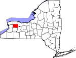
Genesee County, New York Basics:


Genesee County New York - Government Site

Population: 59,896
Area: 493 square miles
County seat: Batavia
Area code(s) in use: 585
Time zone: EST
High school graduate or higher: 90.6%
Bachelor's degree or higher: 20.6%
Median household income: $51,734
Persons in poverty: 11.8%
Home ownership rate: 73.5%
Mean travel time to work: 21.7 minutes


Adjacent counties:
Erie  Livingston  Monroe  Niagara  Orleans  Wyoming  
Find in New York

Map of the Genesee County area


Our detail map of Genesee County shows the Genesee County, New York boundary lines and other interesting items.

Places in Genesee County, New York

  Airports     show all on map

Bethany Airpark, Ely Air Park, Gautieri Heliport, Genesee County Airport, Le Roy Airport, Le Roy Airport (historical), Sackett Farms Airstrip, Stafford Airport, Troop A Headquarters Heliport

  Basins     show all on map

Woodchuck Hole

  Bridges     show all on map

South Lyon Street Bridge

  Buildings     show all on map

Alabama Volunteer Fire Department Station 1, Alabama Volunteer Fire Department Station 2, Alexander Fire Department, Arnold Hotel (historical), Batavia City Fire Department, Batavia City Hall, Batavia Nursing Home, Bergen Volunteer Fire Department, Bethany Volunteer Fire Department, Byron Fire Department, Corfu Fire Department, Darien Volunteer Fire Department, East Pembroke Fire Department, Elba Fire Department, Genesee County Building, Genesee County Childrens Home, Genesee County Court House, Genesee County Highway Department Garage, Genesee County Home (historical), Genesee County Jail, Genesee County Nursing Home, Haxton Memorial Library, Heritage Manor of LeRoy, Holland Land Office Museum, Indian Falls Fire Department, LeRoy Village Fire Department, LeRoy Village Green Residential Health Care Facility, Leroy Volunteer Ambulance Services, Memorial Building, New York State Veterans Home at Batavia, Oakfield Fire Department, Oakfield Town Hall, Pavilion Fire Department, Richmond Memorial Library, South Byron Volunteer Fire Company, Stafford Volunteer Fire Department, Tonawanda Indian Community Center, Town of Batavia Fire Department Station 1, Town of Batavia Fire Department Station 2, Town of Batavia Garage, Town of Oakfield Highway Department, Woodward Memorial Library

  Cemeteries     show all on map

Alabama Cemetery, Alexander Cemetery, Batavia Cemetery, Bethany Cemetery, Byron Cemetery, Cary Cemetery, Creamery Road Cemetery, Darien Cemetery, Daws Corners Cemetery, East Bergen Cemetery, East Bethany Cemetery, East Main Street Cemetery, East Oakfield Cemetery, Elmwood Cemetery, Evergreen Hill Cemetery, Fargo Road Pioneer Cemetery, Fort Hill Cemetery, Four Corners Cemetery, Gardner Cemetery, Grandview Cemetery, Hillside Cemetery, Indian Falls Cemetery, Jug City Cemetery, Langworthy Cemetery, Machpelah Cemetery, Maple Hill Cemetery, Maple Lawn Cemetery, Maple Lawn Cemetery, Maplelawn Cemetery, Morganville Cemetery, Mount Pleasant Cemetery, Mount Rest Cemetery, Myrtle Street Cemetery, Newkirk Cemetery, Nichols Cemetery, North Byron Cemetery, North Pembroke Cemetery, Oakfield-Alabama Cemetery, Oakta Valley Cemetery, Old Buffalo Road Cemetery, Old Saint Marks Episcopal Cemetery, Old Towne Cemetery, Our Lady of Good Counsel Cemetery, Pavilion Center Cemetery, Pine Hill Cemetery, Presbyterian Church Cemetery, Putnam Cemetery, Randall Cemetery, Reed Cemetery, Saint Brigids Catholic Cemetery, Saint Cecilia's Catholic Cemetery, Saint Francis Cemetery, Saint Joseph Cemetery, Saint Marys Cemetery, Sodom Cemetery, Springvale Cemetery, Stafford Cemetery, Stone Church Rural Cemetery, Stone Schoolhouse Cemetery, Thwing Cemetery, Transit Cemetery, Van Allen Cemetery, Walkers Cemetery, Warner Cemetery, West Bethany Cemetery, West Bethany Rural Cemetery

  Census     show all on map

Pavilion Census Designated Place

  Churches     show all on map

Alexander United Methodist Church, Batavia Assembly of God, Bergen United Methodist Church, Bethany Center Baptist Church, Bethel Baptist Church of Bergen, Byron Presbyterian Church, Calvary Baptist Church, Calvary Baptist Church of Le Roy, Calvary Chapel Agape, Church of Brotherly Love, Corfu Presbyterian Church, East Bethany Presbyterian Church, Elba United Methodist Church, Emmanuel Baptist Church, First Baptist Church, First Baptist Church, First Baptist Church of LeRoy, First Church of Christ Scientist, First Presbyterian Church, First Presbyterian Church, First Presbyterian Church, First Presbyterian Church, First United Methodist Church, First Wesleyan Church, Free Methodist Church, Genesee Country Church, Grace Baptist Church, Grace Baptist Church, High Point Church, Immaculate Conception Church, Indian Falls Methodist Church, Kingdom Hall of Jehovahs Witnesses, LeRoy United Methodist Church, Mogadore Chapel, Morganville United Church of Christ, Mount Zion Missionary Baptist Church, New Hope Ministries, North Darien Baptist Church, Northgate Free Methodist Church, Oakfield United Methodist Church, Our Lady of Fatima Church, Our Lady of Good Counsel Church, Pavilion United Methodist Church, Sacred Heart Roman Catholic Church, Saint Anthony Church, Saint Anthony's Roman Catholic Church, Saint Bridget's Church, Saint Cecilia's Roman Catholic Church, Saint Francis of Assisi Church, Saint James Episcopal Church, Saint Joseph's Catholic Church, Saint Joseph's Convent (historical), Saint Joseph's Roman Catholic Church, Saint Marks Episcopal Church, Saint Mary Church, Saint Mary's Roman Catholic Church, Saint Michael's Episcopal Church, Saint Paul's Lutheran Church, Saint Pauls Episcopal Church, Second Baptist Church, Seventh Day Adventist Church, Stone Church Presbyterian Church, The Church of Jesus Christ of Latter Day Saints, United Pentecostal Church, West Bethany Baptist Church

  Falls     show all on map

Buttermilk Falls

  Hospitals     show all on map

Batavia Veterans Affairs Medical Center, Genesee Infirmary (historical), Saint Jerome Hospital (historical), Saint Lukes Manor (historical), United Memorial Medical Center

  Lakes     show all on map

Chapin Pond, Divers Lake, Godfrey Pond, Phelps Pond, Seven Springs Pond, Upper Stafford Marsh

  Locales     show all on map

Apple Tree Acres Corporate Park, Atherton Farms, Bagel Creek Farms, Batavia City Water Pollution Control Plant, Batavia Downs, Batavia Drive-In (historical), Batavia Gateway Corporate Park, Batavia Industrial Center, Batavia Toll Plaza, Bel-Air Ranch Health Camp, Big "N" Plaza Shopping Center, Big O Farms, Bolas Farms, Camp Wakpala, Chestnut Hill Country Club, City of Batavia Pumping Station And Filtration Plant, City of Batavia Sewage Treatment Plant, Corfu Station, Del Mar Farms, Elba Village Wastewater Treatment Plant, Fentons Berry Farm, Flower Fields, Flower Hill Farm, Genesee Drive-In (historical), Harris Farms, Lamb Farms, Lehigh Station (historical), Lei - Ti - Too Campground, Lei - Ti Campground, LeRoy Country Club, LeRoy Toll Plaza, Lor-Rob Dairy Farm, McArthur Stadium, McPherson Orchards, Miller Brothers Farm, Millers Fruit Farm, Misty Mountain Farm, My-T Acres, Northland Farm, Oakfield Rod and Gun Club, Oakfield Village Sewage Treatment Plant, Ontario Westbound Rest Area, Pembroke Eastbound Rest Area, Pembroke Station, Pembroke Toll Plaza, Phelps Corners, Porter Farm, Potoczak Bee Farms, Roanoke Apple Farms, Schafer Potato Farms, Six Flags at Darien Lake Camping Resort, Skyline Camping Resort, Southwoods Recreational Vehicle Resort, Stafford Country Club, Stafford Station, Stein Farms, Sweetland Pines Golf Course, Terry Hills Golf Course, Timberline Lake Park Campground, Top Of World Gardens And Greenhouse, Village of Le Roy Sewage Treatment Plant, Wheatville Station, Williams Poultry Farm

  Military     show all on map

Batavia Armory

  Mines     show all on map

Batavia Pit, Stafford Quarry

  Parks     show all on map

Austin Park, Genesee County Courthouse Historic District, Kibbe Park, Lake Street Historic District, Oak Orchard Creek State Game Refuge, Ross Park, Stafford Village Four Corners Historic District, State Street Park, White Memorial State Game Farm, Williams Park, Woodward Field

  Populated Places     show all on map

Alabama, Alexander, Amherst, Antones's Mobile Home Park, Apple Grove Mobile Home Park, Barbary Coast, Basom, Batavia, Batavia Downs Trailer Park, Bergen, Bethany Center, Brick House Corners, Brookville, Bushville, Byron, Cheektowasa, Cookville, Corfu, Country Meadows, Darien, Darien Center, Daws, Dreamland Mobile Home Park, East Alexander, East Bergen, East Bethany, East Elba, East Oakfield, East Pembroke, Elba, Fargo, Five Corners, Five Corners, Fort Hill, Genesee West, Griswold, Harper Park, Hidden Meadows, Hilltop Acres Mobile Home Park, Indian Falls, Jericon Corners, Junction, Langton Corners, Le Roy, Lehigh, Limerock, Linden, Little Canada, Longwood, Morganville, North Alexander, North Bergen, North Darien, North Le Roxy, North Pembroke, Oakfield, Pavilion, Pavilion Center, Pembroke, Pembroke Center, Pumpkin Hill, Ray, Ridgewood Village, Roanoke, Sawens, South Alabama, South Byron, Stafford, Stone Church, Suicide Corners, Texaco Town, Union Corners, Valley View Park, West Alabama, West Bank Mobile Home Park, West Batavia, West Bergen, West Bethany, Wheatville

  Post Offices     show all on map

Alexander Post Office, Basom Post Office, Batavia Post Office, Bergen Post Office, Byron Post Office, Corfu Post Office, Darien Center Post Office, East Pembroke Post Office, Elba Post Office, South Byron Post Office, Stafford Post Office

  Reservoirs     show all on map

Horseshoe Lake, LeRoy Reservoir, Mill Pond

  Ridges     show all on map

Bulgary Ridge, Limestone Ledge

  Schools     show all on map

Alexander Classical School (historical), Alexander Elementary School, Alexander Middle School - High School, Batavia High School, Batavia Middle School, Brooklyn Avenue School (historical), Byron - Bergen Elementary School, Byron - Bergen High School, Byron - Bergen Middle School, Central School, Elba Elementary School, Elba Junior - Senior High School, Holy Family School, Jackson School, John Kennedy Elementary School, Le Roy Junior - Senior High School, New York State School for the Blind, Notre Dame Parochial High School, Oakfield High School (historical), Oakfield-Alabama Elementary School, Oakfield-Alabama Middle School-High School, Pavilion Junior - Senior High School, Pembroke Junior - Senior High School, Pembroke Primary School, Pringle School (historical), Robert Morris School, Saint Anthony's Roman Catholic School, Saint Josephs Parochial School, Saint Paul Lutheran School, School Number 1 (historical), School Number 1 (historical), School Number 1 (historical), School Number 1 (historical), School Number 1 (historical), School Number 10 (historical), School Number 11 (historical), School Number 11 (historical), School Number 12 (historical), School Number 12 (historical), School Number 16 (historical), School Number 2 (historical), School Number 2 (historical), School Number 2 (historical), School Number 3 (historical), School Number 3 (historical), School Number 3 (historical), School Number 3 (historical), School Number 3 (historical), School Number 4 (historical), School Number 4 (historical), School Number 5 (historical), School Number 6 (historical), School Number 7 (historical), School Number 7 (historical), School Number 7 (historical), School Number 7 (historical), School Number 8 (historical), School Number 8 (historical), School Number 8 (historical), School Number 8 (historical), School Number 9 (historical), School Number 9 (historical), Washington School (historical), Wolcott Street School

  Streams     show all on map

Baker Brook, Bigelow Creek, Bowen Creek, Brinningstool Creek, Crooked Creek, Elevenmile Creek, Huron Creek, Little Tonawanda Creek, Manning Muckland Creek, Mud Creek, North Branch Black Creek, Oatka Creek, Peck Creek, Robins Brook, Spring Creek, White Creek, Whitney Creek

  Summits     show all on map

Burks Hill, Burleigh Hill, Casswell Hill, Forsythe Hill, Harris Hill, Lidke Hill, Nichols Hill, Scarff Hill, Skunk Hill, Temperance Hill, Torpy Hill, Tower Hill

  Swamps     show all on map

Borau Swamp, Byron-Bergen Swamp, Galloway Swamp, Lower Stafford Marsh, Oak Orchard Swamp, Schmidt Marsh

  Towers     show all on map

WBTA-AM (Batavia), WGCC-FM (Batavia),

Genesee County, New York Population By Race (2012 estimate)

RacePopulation
WhiteGenesee County White population 55,94355,942  
BlackGenesee County Black population 1,7971,796
MixedGenesee County Mixed population 1,0781,078
American IndianGenesee County American Indian population 719718
AsianGenesee County Asian population 359359
Hawaiian & Pacific IslanderGenesee County Hawaiian & Pacific Islander population 00

Additional population tables :
State population table
New York population by county