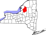
Lewis County, New York Basics:


Lewis County New York - Government Site

Population: 27,222
Area: 1275 square miles
County seat: Lowville
Area code(s) in use: 315
Time zone: EST
High school graduate or higher: 86.8%
Bachelor's degree or higher: 13.1%
Median household income: $45,187
Persons in poverty: 13.5%
Home ownership rate: 77.7%
Mean travel time to work: 22.9 minutes


Adjacent counties:
Herkimer  Jefferson  Oneida  Oswego  St. Lawrence  
Find in New York

Map of the Lewis County area


Our detail map of Lewis County shows the Lewis County, New York boundary lines and other interesting items.

Places in Lewis County, New York

  Airports     show all on map

Duflo Airport, Tug Hill Farm Airport

  Bays     show all on map

Hitchcock Bay

  Benches     show all on map

Palmer Ledge

  Bends     show all on map

Froth Hole

  Bridges     show all on map

Beaver River Bridge, Bryants Bridge, Marshey Road Bridge, Moose River Road Extension Bridge

  Buildings     show all on map

3 - G Volunteer Fire Company Brantingham Station 2, 3 - G Volunteer Fire Company Glenfield Station 1, Beaver Falls Fire Department, Beaver Falls Library, Brookside Senior Living Community, Castorland Volunteer Fire Company, Constableville Volunteer Fire Company, Copenhagen Volunteer Fire Department, Croghan Free Library, Croghan Volunteer Fire Department, Harrisburg Town Hall, Harrisville Volunteer Fire Department, Lewis County General Hospital Residential Health Care Facility, Lewis County Search and Rescue, Lowville Volunteer Fire Department, Lyons Falls Library, Martinsburg Volunteer Fire Department, New Bremen Fire Department, Osceola Public Library, Port Leyden Community Library, Port Leydon Fire Department, Turin Fire Volunteer Fire Company, West Leyden Fire Department

  Capes     show all on map

Bentons Point, Bullrock Point

  Cemeteries     show all on map

Basselin Cemetery, Battle Cemetery, Beaches Bridge Cemetery, Bent Cemetery, Blanchard Cemetery, Brantingham Cemetery, Burdicks Crossing Cemetery, Calvary Cemetery, Carpenter Cemetery, Collins Cemetery, Collinsville Cemetery, Ebblie Cemetery, Fairview Cemetery, Fairview Cemetery, Gallup Cemetery, Gregory Cemetery, Hillside Cemetery, Hillside Cemetery, Leyden Hill Cemetery, Liberty Cemetery, Newton Cemetery, Old Martinsburg Cemetery, Oswegatchie Corners Cemetery, Plank Cemetery, Rural Cemetery, Rural Cemetery, Saint James Cemetery, Saint Marys Cemetery, Saint Michaels Cemetery, Saint Pauls Cemetery, Saint Stephens Cemetery, Saints Peter and Paul Cemetery, Salem Cemetery, Salmon River Cemetery, Sands Cemetery, Sunnyside Cemetery, Swancott Mill Cemetery, Swinburne Cemetery, Turin Cemetery, Union Cemetery, West Leyden Cemetery, Wetmore Cemetery, Wildwood Cemetery

  Channels     show all on map

The Tunnel

  Churches     show all on map

Bible Fellowship Church, Calvary Bible Church, Fisher Memorial Chapel, Forest Presbyterian Church, Gould Memorial Chapel, Lowcille United Methodist Church, Lowville Baptist Church, Lowville Presbyterian Church, Maple Ridge Church, New Covenant Church, New Life Fellowship, Pine Grove Mennonite Church, Rhema Fellowship, River of Life Fellowship, Saint Anthonys Church, Saint Francis Solanus Church, Saint Hedwigs Church, Saint Johns Catholic Church, Saint Johns Church, Saint Marks Church, Saint Mary's Nativity Church, Saint Pauls Church, Saint Peter's Catholic Church, Saint Peters Church, Saint Thomas Church, Saint Vincent De Paul Church, Salem Christian Fellowship Church, South Lewis Methodist Church, The Church of Jesus Christ of Latter Day Saints, Trinity Episcopal Church, United Church of Copenhagen, Zion Church

  Falls     show all on map

Elmer Falls, High Falls, Kings Falls

  Flats     show all on map

Hickey Beaver Meadow, Indian River Flats

  Hospitals     show all on map

Lewis County General Hospital

  Islands     show all on map

Birch Island, Pine Island, Rock Island, Round Island

  Lakes     show all on map

Alexander Pond, Ashcraft Pond, Barnes Lake, Beach Millpond, Beaver Lake, Beaver Pond, Benton Pond, Big Hill Pond, Bills Pond, Blanchard Pond, Bloodsucker Lake, Brantingham Lake, Bullhead Pond, Burnt Pond, Burnt Pond, Calfhead Pond, Catspaw Lake, Chase Lake, Chase Upper Lake, Clark Pond, Clear Pond, Cleveland Lake, Copper Lake, Crooked Lake, Crooked Pond, Crystal Lake, Crystal Pond, Deer Pond, Doherty Pond, Duck Pond, East Pine Pond, East Pond, Elijah Lake, Evies Pond, Fish Pond, Fitzgerald Pond, Francis Lake, French Pond, Goose Pond, Gourd Lake, Green Pond, Haber Pond, Halfmoon Lake, Hinchings Pond, Hogsback Pond, Hopsicker Pond, Huckleberry Lake, Indian Lake, Indian Pond, Johnson Pond, Lake Bonaparte, Lanes Pond, Little Mouldy Pond, Little Otter Lake, Little Pine Lake, Little Punky Pond, Little Rocks Ponds, Little Silver Dawn Lake, Long Lake, Long Pond, Lost Lake, Mahan Pond, Marsh Pond, McCabe Pond, McCarthys Lake, Meister Pond, Mikes Pond, Mouldy Pond, Mud Lake, Mud Pond, Mud Pond, Mudhole Pond, Narrow Lake, Norman Pond, North Pond, Onjebonge Pond, Panther Pond, Parsons Pond, Payne Lake, Pine Lake, Pleasant Lake, Powlish Pond, Quackenbush Pond, Quarry Pond, Rock Pond, Round Pond, Sand Pond, Sand Pond, Sears Pond, Silver Dawn Lake, Snake Pond, Snider Pond, South Greek Lake, Steam Mill Pond, Stewart Pond, Stony Lake, The Inlet, Trout Lake, Trout Pond, Twin Ponds, Twin Sister Lake, West Pine Pond, West Ponds, Woodwardia Pond

  Locales     show all on map

Adirondack 1000 Islands Camping, Bartlett Corners, Blanchard Corners, Bushs Corners, Byron Corners, Cameron Corners, Castorland Village Wastewater Treatment Plant, Cedars Golf Course, Copenhagen Village Wastewater Treatment Plant, Croghan Village Sewage Treatment Plant, Cronk Corners, Deer River Station, Dutton Corners, Eagle Falls, Forks Number Two, Gardners Corners, Glenfield Sewage Treatment Plant, Graves Corners, Hall Dale Acres, Happy Hollow Campground, High Market, Lewisburg, Liberty Corners, Marks Farms, McGraw Corners, Middle Branch Corners, Moser Farm, Moserdale Farm, Natural Bridge Station, Northern Quest Farm, Oswegatchie Corners, Petries Mill (historical), Pinckney Corners, Porters Corners, Potters Corners, Riverjack Ranch, Ross Farms, Sunset Corners, Tabolt Corners, Tinney Corners, Turin Highlands Golf Course, Tylers Corners, Valley Brook Drive-In, Windy Acres

  Parks     show all on map

Sand Flats State Park, Singing Waters Park, Whetstone Gulf State Park, Whittaker Falls Park

  Pillars     show all on map

Deerlick Rock

  Populated Places     show all on map

Alpina, Barnes Corners, Beaver Falls, Belfort, Bellwood, Brantingham, Briggs Corner, Bushes Landing, Castorland, Clark Corners, Collinsville, Constableville, Copenhagen, Croghan, Crystal Dale, Dadville, Deer River, Denmark, Diana Center, East Martinsburg, Fish Creek, Forest City, Fowlersville, Freeman Mill, Glendale, Glenfield, Goulds Mill, Greig, Harrisburg, Harrisville, High Falls, Hooker, Hoseville, Indian River, Jerden Falls, Kimball Mill, Kirschnerville, Kosterville, Lake Bonaparte, Leisher Mill, Locust Grove, Lowville, Lyons Falls, Lyonsdale, Martinsburg, Michigan Mills, Mohawk Hill, Monteola, Naumburg, New Boston, New Bremen, New Campbellwood Wye, North Croghan Crossing, North Osceola, Number Four, Old Campbellwood Wye, Osceola, Otter Creek, Page, Parkers, Parson Mill, Petries Corners, Pine Grove, Port Leyden, Rector, Remington Corners, Shuetown, Soft Maple, Sperryville, Swancott Mill, Talcottville, Texas, Turin, Watson, Welch Hill, West Leyden, West Lowville, West Martinsburg, Wetmore, Windecker

  Post Offices     show all on map

Beaver Falls Post Office, Castorland Post Office, Croghan Post Office, West Leyden Post Office

  Reservoirs     show all on map

Belfort Pond, Carthage Reservoir, Croghan Reservoir, Effley Falls Pond, Elmer Falls Pond, High Falls Pond, Lowville Reservoir, Mud Lake, Soft Maple Reservoir, Stone Pond, Taylorville Pond, Turin Reservoir

  Ridges     show all on map

Brushy Ridge

  Schools     show all on map

Beaver River School, Beech Hill School (historical), Central School, Central School, Copenhagen Central School, Crystal Lake School (historical), Dicob School (historical), Gen Martin High School, Harrisville Elementary School, Harrisville Junior - Senior High School, Henry School (historical), Lowville Elementary School, Lowville High School, Lowville Middle School, Monnatt School (historical), Ossoit School (historical), Our Lady of Peace School, Puffer School (historical), Saint Peters Catholic School, School Number 1 (historical), School Number 1 (historical), School Number 1 (historical), School Number 10 (historical), School Number 10 (historical), School Number 11 (historical), School Number 11 (historical), School Number 11 (historical), School Number 11 (historical), School Number 12 (historical), School Number 13 (historical), School Number 13 (historical), School Number 14 (historical), School Number 14 (historical), School Number 16 (historical), School Number 17 (historical), School Number 19 (historical), School Number 2 (historical), School Number 2 (historical), School Number 2 (historical), School Number 2 (historical), School Number 3 (historical), School Number 3 (historical), School Number 3 (historical), School Number 3 (historical), School Number 3 (historical), School Number 3 (historical), School Number 3 (historical), School Number 4 (historical), School Number 4 (historical), School Number 4 (historical), School Number 4 (historical), School Number 4 (historical), School Number 4 (historical), School Number 5 (historical), School Number 5 (historical), School Number 5 (historical), School Number 5 (historical), School Number 5 (historical), School Number 5 (historical), School Number 6 (historical), School Number 6 (historical), School Number 6 (historical), School Number 6 (historical), School Number 6 (historical), School Number 6 (historical), School Number 6 (historical), School Number 7 (historical), School Number 7 (historical), School Number 7 (historical), School Number 7 (historical), School Number 7 (historical), School Number 8 (historical), School Number 8 (historical), School Number 8 (historical), School Number 8 (historical), School Number 9 (historical), School Number 9 (historical), School Number 9 (historical), School Number 9 (historical), School Number 9 (historical), School Number 9 (historical), South Lewis High School, South Lewis Middle School, Strifts School (historical), Sweet School (historical), Swiss Road School (historical), Texas Road School (historical), Tucker School (historical), West Leyden Elementary School, Wisner School (historical)

  Streams     show all on map

Alder Creek, Alder Creek, Alder Creek, Atwater Creek, Baker Brook, Balsam Creek, Balsam Creek, Beauty Creek, Beaver Meadow Brook, Beaver Meadow Brook, Beaver Meadow Creek, Beaver River, Black Creek, Black Creek, Black River, Blanchard Creek, Blanchard Creek, Blue Swamp Creek, Bonaparte Creek, Broad Brook, Browns Creek, Buckhorn Creek, Burning Creek, Burnt Creek, Butler Creek, Capidon Creek, Clark Creek, Clear Creek, Cobb Creek, Cold Brook, Cold Creek, Cold Spring Creek, Compo Creek, Copper Creek, Cowles Creek, Crooked Brook, Crooked Creek, Crystal Creek, Deep Creek, Deer River, Deerlick Creek, Denning Creek, Desert Creek, Dirreen Creek, Dobson Creek, Douglass Creek, Drunkard Creek, East Fork Salmon River, Edick Creek, Elijah Creek, Emerson Creek, Fall Brook, Fall Brook, Fifth Creek, Finnegan Brook, First Creek, Fish Creek, Fish Creek, Fourth Creek, Fourth Creek, Harvey Creek, Heron Brook, Hodge Creek, Hogs Back Creek, Hogsback Creek, Hooker Brook, House Creek, Independence River, Keese Brook, Kelly Creek, Kimball Creek, Lilypad Creek, Little Alder Creek, Little Otter Creek, Little Pine Creek, Luther Creek, Malloy Brook, McNeil Creek, Middle Branch Oswegatchie River, Middle Branch Pine Creek, Mill Creek, Mill Creek, Miller Brook, Mink Creek, Moore Meadow Stream, Moose River, Mud Brook, Mud Creek, Mulligan Brook, Mulligan Creek, Murmur Creek, Negro Creek, North Branch Fish Creek, North Branch Mad River, North Branch Sugar River, Olmstead Brook, Onemile Creek, Oswegatchie Creek, Otter Creek, Palmer Creek, Panther Creek, Pepperbox Creek, Perrigo Creek, Pickens Brook, Pine Creek, Pine Creek, Pine Creek, Pine Creek, Pond Brook, Potash Creek, Powlish Pond Brook, Pringle Creek, Rainbow Creek, Reynolds Creek, Roaring Brook, Roaring Brook, Roaring Brook, Sammys Creek, Sandy Creek, Scuttle Hole Creek, Searles Brook, Second Creek, Second Creek, Sevenmile Creek, Shaw Brook, Silver Brook, Silver Dawn Creek, Sixmile Creek, Smith Brook, South Branch Crystal Creek, South Branch Mad River, South Creek, Stony Creek, Stony Creek, Stucky Creek, Sucker Brook, Swiss Creek, Swiss Creek, Third Creek, Third Creek, Threemile Creek, Tims Creek, Tommy Roaring Creek, Trout Lake Creek, Twin Sister Creek, Twomile Creek, Twomile Creek, Warner Creek, Weatherhead Creek, West Branch Deer River, West Branch Oswegatchie River, West Branch Sugar River, West Fork Salmon River, Whetstone Creek, White River, Widmeyer Creek, Yellow Creek

  Summits     show all on map

Bald Mountain, Beech Hill, Big Hill, Buck Mountain, Charlies Hill, Gomer Hill, Grassy Hill, John Browns Mountain, Middle Hill, Mount Tom, Mount Tom, Panther Mountain, Pine Hill, Tug Hill, Wards Hill

  Swamps     show all on map

Bailey Swamp, Bear Swamp, Beartown Swamp, Black Ash Swamp, Blanchard Swamp, Blue Swamp, Bobcat Swamp, Carley Swamp, Carley Swamp, Cedar Swamp, Cold Swamp, Compo Swamp, Doe Swamp, Dutchmans Swamp, Long Swamp, Mountain Swamp, Patchin Swamp, Pine Creek Swamp, Prittie Swamp, Punky Swamp, Putman Swamp, Schoolhouse Swamp, Sunday Swamp

  Towers     show all on map

Swancott Lookout Tower, WBRV-AM (Boonville), WJNY-FM (Watertown), WLLG-FM (Lowville), WNPE-TV (Watertown), WWTI-TV (Watertown)

  Valleys     show all on map

Bear Gulf, Whetstone Gulf,

Lewis County, New York Population By Race (2012 estimate)

RacePopulation
WhiteLewis County White population 26,56926,568  
MixedLewis County Mixed population 272272
BlackLewis County Black population 218217
AsianLewis County Asian population 8281
American IndianLewis County American Indian population 5454
Hawaiian & Pacific IslanderLewis County Hawaiian & Pacific Islander population 2727

Additional population tables :
State population table
New York population by county