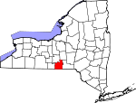
Tioga County, New York Basics:


Tioga County New York - Government Site

Population: 50,413
Area: 519 square miles
County seat: Owego
Area code(s) in use: 607
Time zone: EST
High school graduate or higher: 91.5%
Bachelor's degree or higher: 23.5%
Median household income: $56,488
Persons in poverty: 8.8%
Home ownership rate: 79.9%
Mean travel time to work: 23.9 minutes


Adjacent counties:
Bradford (PA)  Broome  Chemung  Cortland  Susquehanna (PA)  Tompkins  
Find in New York

Map of the Tioga County area


Our detail map of Tioga County shows the Tioga County, New York boundary lines and other interesting items.

Places in Tioga County, New York

  Airports     show all on map

IBM Owego Heliport, Kohn Airport, Saikkonen Airport, Susquehanna Heliport, Tioga Airport

  Bridges     show all on map

Main Street Bridge, Turners Bridge, West Creek Road Bridge

  Buildings     show all on map

Apalachin Fire Department, Berkshire Fire Department, Berkshire Free Library, Campville Fire Department Station 1, Candor Emergency Squad, Candor Fire Department, Candor Free Library, Coburn Free Library, George P and Susan Platt Cady Library, Newark Valley Depot Museum, Newark Valley Fire Department, Nichols Fire Department, Owego Fire Department, Owego Fire Department Emergency Squad, Richford Fire Department, Riverview Manor Nursing Home, South Side Fire Department, Spencer Library, Tappan - Spaulding Memorial Library, Tioga Center Fire Department, Tioga County Court House, Tioga Fire Company, Waverly Barton Fire District Station 1, Waverly Barton Fire District Station 2, Waverly Free Library, Weltonville Fire Company

  Cemeteries     show all on map

Anderson Hill Cemetery, Arbor Glade Cemetery, Asbury Church Cemetery, Baptist Corners Cemetery, Barton Center Cemetery, Barton Methodist Church Cemetery, Beaver Meadows Cemetery, Briggs Hollow Cemetery, Broadway Cemetery, Brown Cemetery, Bushnell Cemetery, Camp Cemetery, Campville Cemetery, Chapel Hill Cemetery, East Berkshire Cemetery, East Waverly Cemetery, Emory Chapel Cemetery, Evergreen Cemetery, Evergreen Cemetery, Evergreen Cemetery, Evergreen Cemetery, Ferris Cemetery, Flemingville Cemetery, Forest Home Cemetery, Germany Hill Cemetery, Gibson Corners Cemetery, Glen Hope Cemetery, Glenwood Cemetery, Halsey Valley Cemetery, Hiawatha Cemetery, Highland Cemetery, Holcombville Church Cemetery, Hollenbeck Cemetery, Hope Cemetery, Ketchumville Cemetery, Light Cemetery, Maple Grove Cemetery, Nichols Cemetery, North Barton Cemetery, North Candor Cemetery, North Spencer Cemetery, Oak Hill Cemetery, Old Cemetery, Old Lounsberry Cemetery, Old Riverside Cemetery, Pleasant Valley Cemetery, Presbyterian Union Church Cemetery, Prospect Hill Cemetery, Railroad Avenue Cemetery, Riverside Cemetery, Riverside Cemetery, Saint James Cemetery, Saint Johns Cemetery, Saint Joseph's Cemetery, Saint Patricks Cemetery, Schumacher Road Cemetery, Searlestown Cemetery, Settle Cemetery, Smith Valley Cemetery, Smithboro Cemetery, Smithboro Methodist Cemetery, South Owego Cemetery, Tallmadge Hill Cemetery, Tioga Cemetery, Tioga Center Cemetery, Upper Fairfield Cemetery, Waits Cemetery, Weltonville Cemetery, West Candor Cemetery, West Newark Cemetery, Wood Cemetery, Woodbridge Cemetery, Zimmer Cemetery

  Census     show all on map

Apalachin Census Designated Place

  Channels     show all on map

The Narrows

  Churches     show all on map

Abide in the Vine Fellowship, Allen Memorial Baptist Church, Apalachin Christian And Missionary Alliance Church, Apalachin United Methodist Church, Asbury Church, Assembly of God Church, Barton United Methodist Church, Bible Baptist Church, Bible Baptist Church, Bridge of Hope Ministries, Candor Congregational Church, Christian And Missionary Church, Christian Life Church, Church of Christian Gospel Faith, Church of the Nazarene, Church of the Nazarene, Community Baptist Church, East Berkshire United Methodist Church, Emory Chapel, Faith Bible Chapel, Faith Christian Academy Church, Faith Southern Baptist Church, First Baptist Church, First Baptist Church, First Baptist Church of Owego, First Congregational Church, First Congregational Church of Christ, First Presbyterian Church, First Presbyterian Union Church, First United Methodist Church of Newark Valley, Flemingville United Methodist Church, Gibson Corners United Methodist Church, Gospel Chapel, Gospel Chapel, Heart of God's Fellowship Church, Highland Chapel, Hocumville Church, Holy Counselor Church, Kingdom Hall of Jehovah's Witnesses, Lakeview Chapel, Living Water Baptist Church, Lord Hill Church, Lounsberry United Methodist Church, Nichols Baptist Church, Nichols United Methodist Church, North Waverly Chapel, Owego United Methodist Church, Park Terrace United Methodist Church, Reformed Presbyterian Church, Richford Congregational Church, Saint Francis Church, Saint James Catholic Church, Saint John The Evangelist Church, Saint Margaret Mary's Church, Saint Marks Episcopal Church, Saint Marys Church, Saint Maximus Orthodox Christian Church, Saint Patrick's Church, Saint Paul's Episcopal Church, Saint Paul's Lutheran Church, Seventh Day Adventist Church, South Apalachin Baptist Church, South Owego Bible Church, Spencer Federated Church, Straits Corners Baptist Church, Sulphur Springs Chapel, Sword And The Spirit Christian Church, The Church of Jesus Christ of Latter Day Saints, Tioga Center Baptist Church, Tioga Center United Methodist Church, Tree of Life Christian Fellowship, United Methodist Church of Waverly, West Creek Church, Whittemore Hill Methodist Church, Zion Lutheran Church

  Cliffs     show all on map

Devils Elbow

  Falls     show all on map

Buttermilk Falls

  Flats     show all on map

Kenny Flats

  Forests     show all on map

Fairfield State Forest, Ketchumville State Forest, Oakley Corners State Forest, Robinson Hollow State Forest

  Hospitals     show all on map

Candor Health Center, Guthrie Medical Center, Guthrie Nursing Center, Northern Tioga Family Health Center, Owego Family Practice Health Center

  Islands     show all on map

Hiawatha Island, Hoopers Valley Island, Squaw Island, Tuffs Island

  Lakes     show all on map

Dodge Pond, Empire Lake, Holden Pond, Lake Diana, Mutton Hill Pond, Rightmire Pond, Spencer Lake, Summit Pond, Zorn Pond

  Locales     show all on map

AA Dairy, Angel Ridge Farm, Apalachin Golf Course, Birthplace of John D Rockefeller, Blue J Farm, Catatonk Golf Course, Crocker Creek Buffalo Farm, East Beecher Hill Community Club, Fallow Hollow Deer Farm, Fish Haven Farm, Gentle Creek Horse Farm, Grandview Farms Golf Course, Hollybrook Country Club, Iron Kettle Farm, Jewell Farms, Kingbird Farm, Klett Farm, Klossner Farms, Locust Woods Farm, Mandeville Farm, Mountain Top Greenhouses, Newark Valley Golf Club, Nichols Southbound Rest Area, Oakley Corners, Owego Northbound Rest Area, Owego Village Sewage Treatment Plant, Owego Water Pollution Control Point Number 2, Siren Farms, Southern Tier Nurseries, Stoughton Farm, Sunnyside Farm, The Club at Shepard Hills, The Links At Hiawatha Landing, The Links at Hiawatha Landing, Tioga Country Club, Tioga Gardens, Tioga Industrial Park, Tri-K Farms, Waits, Waverly Stadium, Wildrose Farm

  Mines     show all on map

Albro Pit, Barton Gravel Pit, Owego Pit, Spencer - Kozanosky Pit

  Parks     show all on map

Apalachin Marsh Bird Sanctuary, Boland Park, Campville Commons, Draper Park, Hiawatha Island Wildlife Refuge, Hyde Park, Kirby Park, Lane Collyer Field, Livingston Park, Marvin Park, Muth Park, Newark Valley Village Green, Nichols Park, Shephard Park, The Hickories Park, Trout Ponds Park, Waverly Memorial Park

  Populated Places     show all on map

Airways Mobile Home Park, Apalachin, Barton, Berkshire, Briggs Hollow, Campville, Candor, Catatonk, Catlin Hill, Cedar Park Terrace, Crest View Heights, Crimson Mobile Home Court, Crum Town, East Berkshire, East Newark, East Nichols, East Richford, East Waverly, Ellistown, Fairfield, Flemingville, Foster, Gaskill, Germany Hill, Gibson Corners, Glencairn, Glenmary Mobile Home Park, Goodrich, Gridleyville, Halsey Valley, Hamar Estates, Hamar Mobile Home Estates, Hillview Terrace Mobile Home Park, Hoopers Valley, Horton Crossing, Howland Mobile Home Park, Hubbardtown, Hullsville, Jenksville, Jewell Mobile Home Park, Ketchumville, Litchfield, Lockwood, Lounsberry, Maple Lane Mobile Home Park, Maple Shade Trailer Park, Maple Shade Trailer Park, Mountain View Mobile Home Park, New Connecticut, Newark Valley, Nichols, North Barton, North Spencer, North Waverly, Owego, Owego Heights, Owego Heights Mobile Home Park, Park Terrace, Pebble Hill Mobile Home Park, Pine Tree Mobile Home Park, Post Trailer Park, Price Home, Reniff, Richford, Smithboro, South Apalachin, South Owego, Spencer, Stephens Mobile Home Community, Stephens Trailer Park, Straits Corners, Tioga Center, Tioga Terrace, Upper Fairfield, Valley Mobile Home Park, Van Housen Mobile Home Park, Waverly, Weltonville, West Candor, West Newark, Whittemore, Willseyville, Wilson Creek

  Post Offices     show all on map

Apalachin Post Office, Lockwood Post Office, Newark Valley Post Office, Richford Post Office, Willseyville Post Office

  Reservoirs     show all on map

Alexander Lake, Hill Top Lake, Nichols Pond, Owego Reservoir, Waverly Reservoirs

  Schools     show all on map

Apalachin Elementary School, Candor Elementary School, Candor Junior-Senior High School, Elm Street Elementary School, Gladden School, Ithaca Street School, Lincoln Street Elementary School, Nathan T Hall Elementary School, Newark Valley Middle School, Newark Valley Senior High School, Nichols Elementary School, Nichols Elementary School, North Spencer Christian Academy, Owego Elementary School, Owego Free Academy, Owego-Apalachin Middle School, Saint James School, Saint Patrick School, School Number 8 (historical), Spencer-Van Etten High School, Spencer-Van Etten Middle School, Thomas J Watson Sr Elementary School, Tioga Center Christian School, Tioga Elementary School, Tioga Hills Elementary School, Tioga Hills Elementary School, Tioga Middle School, Tioga Senior High School, Waverly Senior High School, Zion Lutheran School

  Springs     show all on map

Sulphur Spring

  Streams     show all on map

Apalachin Creek, Babcock Run, Barnes Creek, Bliven Creek, Boyer Creek, Burheight Creek, Butson Creek, Catatonk Creek, Chambers Creek, Cold Brook, Cole Brook, Danby Creek, Dead Creek, Dean Creek, Dean Creek, Deerlick Creek, Doolittle Creek, Dry Brook, Dry Brook, Dry Brook, East Branch Owego Creek, Ellis Brook, Ellis Creek, Evelin Hill Creek, Flag Marsh Run, Hoyt Creek, Hubbard Hill Brook, Hubby Creek, Huntington Creek, Hunts Creek, Little Nanticoke Creek, Little Wapessening Creek, Miami Creek, Michigan Creek, Miller Creek, Owego Creek, Owl Creek, Parks Creek, Pipe Creek, Pumpelly Creek, Reed Brook, Russell Run, Sackett Creek, Seelytown Creek, Smith Creek, South Branch Catatonk Creek, Spring Brook, Sulphur Springs Creek, Wappasening Creek, West Branch Owego Creek, Willseyville Creek, Wilson Creek

  Summits     show all on map

Bogart Hill, Cafferty Hill, Candor Hill, Diamond Peak, East Beecher Hill, East Whitcomb Hill, Hubbard Hill, King Hill, Lillie Hill, Nixon Hill, Oak Hill, Poverty Knob, Prospect Hill, Ross Hill, Tallmadge Hill, Turkey Hill, West Beecher Hill, West Hill

  Towers     show all on map

WAVR-FM (Waverly), WCII-FM (Spencer), WEBO-AM (Owego), WQXT-FM (Owego)

  Valleys     show all on map

Allen Glen, Briggs Hollow, Diamond Valley, Frost Hollow, Gay Hollow, King Hollow, Negro Hollow, Prospect Valley, Shindagin Hollow, Shipman Hollow, Thorn Hollow, Tyler Hollow,

Tioga County, New York Population By Race (2012 estimate)

RacePopulation
WhiteTioga County White population 48,90148,900  
MixedTioga County Mixed population 555554
BlackTioga County Black population 454453
AsianTioga County Asian population 403403
American IndianTioga County American Indian population 101100
Hawaiian & Pacific IslanderTioga County Hawaiian & Pacific Islander population 00

Additional population tables :
State population table
New York population by county